Want more images or videos?
Request additional images or videos from the seller
1 of 21
ANTIQUE 1868 ILLUSTRATED ALL ROUND THE WORLD BOOK INCLUDING HAND PAINTED MAPs
Price:$759
$895.75List Price
About the Item
- Creator:William Collins (Author)
- Dimensions:Height: 12.01 in (30.5 cm)Width: 8.86 in (22.5 cm)Depth: 2.96 in (7.5 cm)
- Style:High Victorian (Of the Period)
- Materials and Techniques:
- Place of Origin:
- Period:
- Date of Manufacture:1868
- Condition:Wear consistent with age and use. Minor fading.
- Seller Location:West Sussex, GB
- Reference Number:1stDibs: LU2823335531192
About the Seller
4.7
Platinum Seller
Premium sellers with a 4.7+ rating and 24-hour response times
Established in 2012
1stDibs seller since 2017
2,103 sales on 1stDibs
Typical response time: 1 hour
Authenticity Guarantee
In the unlikely event there’s an issue with an item’s authenticity, contact us within 1 year for a full refund. DetailsMoney-Back Guarantee
If your item is not as described, is damaged in transit, or does not arrive, contact us within 7 days for a full refund. Details24-Hour Cancellation
You have a 24-hour grace period in which to reconsider your purchase, with no questions asked.Vetted Professional Sellers
Our world-class sellers must adhere to strict standards for service and quality, maintaining the integrity of our listings.Price-Match Guarantee
If you find that a seller listed the same item for a lower price elsewhere, we’ll match it.Trusted Global Delivery
Our best-in-class carrier network provides specialized shipping options worldwide, including custom delivery.You May Also Like
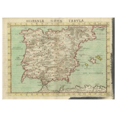
Antique Map of Spain including the Balearic Islands
Located in Langweer, NL
Antique map titled 'Hispania Nova Tabula'. Ruscelli's map of Spain, including the Balearic Islands. This map originates from 'Espositione & introduttioni universali di Gir. Ruscelli sopra tutta la Geografia di Tolomeo (..)' published by Girolamo Ruscelli, 1561.
Girolamo Ruscelli (1500-1566) was a cartographer, humanist, and scholar from Tuscany. Ruscelli was a prominent writer and editor in his time, writing about a wide variety of topics including the works of Giovanni Boccaccio and Francesco Petrarch, Italian language, Italian poetry, medicine, alchemy, and militia. One of his most notable works was a translation of Ptolemy’s Geographia...
Category
Antique 16th Century Maps
Materials
Paper
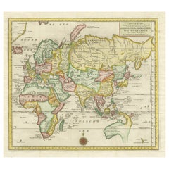
Large Antique Map of Asia including All of Southeast Asia, c.1792
Located in Langweer, NL
Antique map titled 'L' Asie Divisee en ses Empires, Royaumes, et Etats'. Attractive, large map of Asia including all of Southeast Asia. The cartography is archaic for the period with...
Category
Antique 18th Century Maps
Materials
Paper

$1,801
Free Shipping
H 20.67 in W 25.4 in D 0 in
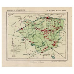
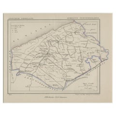
Antique Map of Dantumadeel, Friesland, The Netherlands, 1868
Located in Langweer, NL
Antique map titled 'Provincie Friesland - Gemeente Dantumadeel'. Map of the township of Dantumadeel including Birdaard, Rinsumageest, Veenwouden and many other villages. This map ori...
Category
Antique 19th Century Maps
Materials
Paper
Antique The Fables Book, Historic Literature, English, Illustrated, Victorian
Located in Hele, Devon, GB
This is a superb antique edition of 'The Fables' by Jean de La Fontaine, translated into English verse by Walter Thornbury and illustrated throughout by Gustave Doré. A fine, intact ...
Category
Antique 1870s British Victorian Books
Materials
Paper
$1,021
H 12.21 in W 10.04 in D 2.56 in
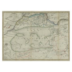
Antique Map of North Africa including the Sahara Desert
Located in Langweer, NL
Antique map titled 'Charte von Nord-Africa'. Scarce map of North Africa. Includes a fantastic depiction of the Sahara Desert. Published in Weimar, 1809.
Category
Antique Early 19th Century Maps
Materials
Paper
$566 Sale Price
20% Off
H 12.6 in W 17.52 in D 0.02 in
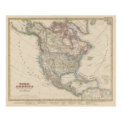
Antique Map of North America Including the West Indies
Located in Langweer, NL
Original antique map titled 'Nord-America'. Old map of North America and the West Indies. Also showing British Overseas Territories and Hudson Bay.
This map originates from Stiel...
Category
Antique Mid-19th Century German Maps
Materials
Paper
$522 Sale Price
25% Off
H 14.65 in W 17.88 in D 0.02 in
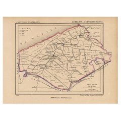
Antique Map of the County Ferwerderadeel, Friesland, The Netherlands, 1868
Located in Langweer, NL
Antique map titled 'Provincie Friesland - Gemeente Ferwerderadeel'. Map of the township of Ferwerderadeel including Ferwerd, Blija and many other villages. This map originates from '...
Category
Antique 19th Century Maps
Materials
Paper
$192
H 7.49 in W 9.85 in D 0 in
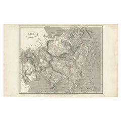
Antique Map of Asia including Arabia, 1806
Located in Langweer, NL
Antique map titled 'Asia'. Original antique map of the Asian continent engraved by E. Jones.
Artists and Engravers: Drawn under the direction of Mr. Arrowsmith. Published in 1806...
Category
Antique 19th Century Maps
Materials
Paper
Antique Map of the Eastern Part of the World
Located in Langweer, NL
Antique map titled 'Nieuwe Kaart van het Oostelykste Deel der Weereld, diendende tot aanwyzing van de Scheepstogten der Nederlanderen Naar Oostindie'. This finely engraved map of the...
Category
Antique Mid-18th Century Maps
Materials
Paper
$634 Sale Price
20% Off
Free Shipping
H 16.15 in W 17.96 in D 0.02 in
Antique Map of Ferwerderadeel, a County in Friesland, The Netherlands, 1868
Located in Langweer, NL
Antique map titled 'Provincie Friesland - Gemeente Ferwerderadeel'. Map of the township of Ferwerderadeel including Ferwerd, Blija and many other villages. This map originates from '...
Category
Antique 19th Century Maps
Materials
Paper
$216
H 11.42 in W 12.6 in D 0 in
More From This Seller
View AllVintage World Map Mirror Based on the Original by Johnson 1882 Military Campaign
Located in West Sussex, Pulborough
We are delighted to offer for sale this lovely Antique style pictorial plan map of the globe based on the original by Johnson in 1882
This is a very interesting and decorative pie...
Category
20th Century English Campaign Maps
Materials
Mirror

Fine French Antique 1856 Hand Watercolour Map of Dept Des Hautes Pyrenees
Located in West Sussex, Pulborough
We are delighted to offer for sale this stunning 1856 hand watercolour map of the Austrian Alps titled Dept Des Hautes Pyrenees taken from the Atlas Nat...
Category
Antique 1850s French Early Victorian Maps
Materials
Paper

Staffordshire 1645 Hand Colored Antique Print Staffordiensis Comitatvs Map
Located in West Sussex, Pulborough
We are delighted to offer for sale this lovely antique Atlas page map of Staffordshire printed in 1645 Amsterdam Staffordiensis Comitatvs Vulgo
This o...
Category
Antique Early 1800s English Georgian Maps
Materials
Paper

Silver Leaf Foil Wall World Map Engraving Based on the Original Moses Pitt, 1681
Located in West Sussex, Pulborough
We are delighted to offer for sale this lovely antique style pictorial silver leaf foil world map taken from and original engraving my Moses Pitt, 1681
This is a very interesting ...
Category
20th Century English Modern Maps
Materials
Silver Leaf

Beautiful Colour French Antique 1856 Hand Watercolour Map of Dept Des La Corse
Located in West Sussex, Pulborough
We are delighted to offer for sale this stunning 1856 hand watercolour map of the Austrian Alps titled Dept Des La Course taken from the Atlas National ...
Category
Antique 1850s French Early Victorian Maps
Materials
Paper

Fine Antique 1856 Hand Watercolour Map of Dept Des Hautes Alpes by Levasseur
s
Located in West Sussex, Pulborough
We are delighted to offer for sale this stunning 1856 hand watercolour map of the Austrian Alps titled Dept Des Hautes Alpes taken from the Atlas National...
Category
Antique 1850s French Early Victorian Maps
Materials
Paper

Still Thinking About These?
All Recently ViewedMore Ways To Browse
Hand Painted Antique Map
Suzanne Slesin
T Powers
The Al Thani Collection
Treasures Of Tutankhamun
Used Office Furniture Santa Barbara
Used Office Furniture Savannah
Vampire Books
Vintage Atlas Book
Vintage Ledger Book
Waverly Novels
Aaron Aujla
Alan Walters
Amanda Lindroth
Andrew Wyeth Book
Anna Hu
Antique Furniture Markham
Antique Miniature Books