Want more images or videos?
Request additional images or videos from the seller
1 of 8
California and Its Gold Regions by Fayette Robinson
$750List Price
About the Item
- Dimensions:Height: 8.5 in (21.59 cm)Width: 5 in (12.7 cm)Depth: 1.5 in (3.81 cm)
- Materials and Techniques:
- Place of Origin:
- Period:
- Date of Manufacture:1849
- Condition:Wear consistent with age and use. Minor losses.
- Seller Location:San Francisco, CA
- Reference Number:Seller: C1021-41A1stDibs: LU855245059652
About the Seller
5.0
Recognized Seller
These prestigious sellers are industry leaders and represent the highest echelon for item quality and design.
Platinum Seller
Premium sellers with a 4.7+ rating and 24-hour response times
Established in 1982
1stDibs seller since 2008
382 sales on 1stDibs
Typical response time: 1 hour
Associations
The Art and Antique Dealers League of AmericaAntiques Associations Members
Authenticity Guarantee
In the unlikely event there’s an issue with an item’s authenticity, contact us within 1 year for a full refund. DetailsMoney-Back Guarantee
If your item is not as described, is damaged in transit, or does not arrive, contact us within 7 days for a full refund. Details24-Hour Cancellation
You have a 24-hour grace period in which to reconsider your purchase, with no questions asked.Vetted Professional Sellers
Our world-class sellers must adhere to strict standards for service and quality, maintaining the integrity of our listings.Price-Match Guarantee
If you find that a seller listed the same item for a lower price elsewhere, we’ll match it.Trusted Global Delivery
Our best-in-class carrier network provides specialized shipping options worldwide, including custom delivery.You May Also Like
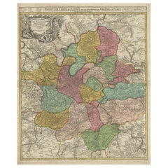
Detailed 18th-Century Map of Paris and Its Surrounding Regions by Johann Homann
Located in Langweer, NL
This map, titled “Agri Parisiensis Tabula particularis,” was created and published by the German cartographer Johann Baptist Homann (1664–1724), or his workshop, in Nuremberg. Homann...
Category
Antique 1720s Maps
Materials
Paper
$403
H 24.02 in W 20.48 in D 0.01 in
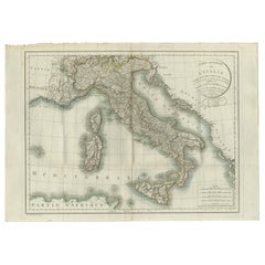
Map of Italy and Neighboring Regions by Delamarche – Antique Map, c.1800
Located in Langweer, NL
Antique Map of Italy and Surrounding Regions by Delamarche, circa 1800
This elegant and detailed antique map titled Carte Générale de l’Italie was drawn and engraved by the French g...
Category
Antique Early 1800s French Maps
Materials
Paper
$676
H 22.45 in W 31.7 in D 0.01 in
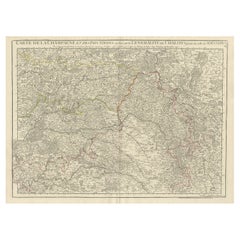
Antique Map of Champagne and surrounding Regions, France
Located in Langweer, NL
Antique map titled 'Carte de la Champagne et des Pays Voisins (..)'. Detailed map of Champagne and surrounding regions of Chalons and Soissons, Reims,...
Category
Antique Mid-18th Century Maps
Materials
Paper
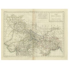
Antique Map of Northern India, Bengal, and Surrounding Regions by Tardieu, 1802
Located in Langweer, NL
This is an original antique map titled "Inde, Indostan Bengale &c. et Partie Septentrionale de la Presqu'isle en deça du Gange," depicting the northern part of the Indian subcontinen...
Category
Antique Early 1800s Maps
Materials
Paper
$417 Sale Price
20% Off
H 16.34 in W 22.25 in D 0.01 in
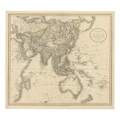
Original 1806 Engraved Map of Asia and Surrounding Regions by John Cary
Located in Langweer, NL
The map titled "A New Map of Asia, From the Latest Authorities" was published in 1806. It is a detailed and comprehensive depiction of the continent of Asia, extending from Europe and the Arabian Peninsula in the west to Japan and the Pacific Islands in the east, and from the Arctic regions in the north to parts of New Holland (Australia) and the Indian Ocean in the south.
The map is finely engraved, with political boundaries delineated using color to distinguish different empires, kingdoms, and colonial possessions of the time. Key geographical features such as mountain ranges, rivers, and major cities are clearly marked. It also includes significant maritime routes and islands across the Indian and Pacific Oceans, reflecting the global trade and exploration activities of the early 19th century.
Notable Features:
- Asia is represented with its vast and diverse regions, including the extensive Russian Empire in the north, the Ottoman Empire in the west, the Qing Dynasty's control over China, and the Mughal Empire's influence in India, which is under increasing British control.
- India is shown with its numerous princely states, many of which are under British influence or control.
- Southeast Asia includes the colonial possessions of European powers, particularly the Dutch East Indies, Spanish Philippines...
Category
Antique Early 1800s English Maps
Materials
Paper
$749 Sale Price
20% Off
H 19.41 in W 21.46 in D 0.01 in
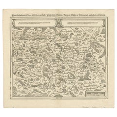
Early Woodcut Map of Franconia and Surrounding Regions, 1628
Located in Langweer, NL
Title: Early Woodcut Map of Franconia and Surrounding Regions, 1628
Franconia (Franckenlande) is a region in Germany. Historically, Franconia was a significant part of the Holy Roma...
Category
Antique 1620s Maps
Materials
Paper
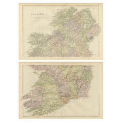
1882 Cartographic Views of Ireland
s North and South Regions
Located in Langweer, NL
Title: 1882 Maps of Ireland: Northern and Southern Regions
These two maps provide a detailed representation of Ireland as it was in 1882, divided into the northern and southern regi...
Category
Antique 1880s Maps
Materials
Paper
$427 / set
H 14.97 in W 11.03 in D 0.01 in
Antique Map of the Arctic Regions by Lowry
1852
Located in Langweer, NL
Antique map titled 'Arctic Regions'. Original map of the Arctic Regions. This map originates from 'Lowry's Table Atlas constructed and engraved from the most recent Authorities' by J...
Category
Antique Mid-19th Century Maps
Materials
Paper

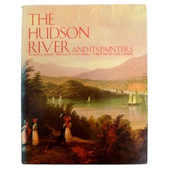
Hudson River And Its Painters by John K. Howat
Located in valatie, NY
Hudson River And Its Painters by John K. Howat. Published by American Legacy Press, 1983. Hardcover with dust jacket. Foreword by Carl Carmer, preface by James Biddle. Contains works...
Category
Vintage 1980s American Books
Materials
Paper
The Bennington Battle Monument Its Story and Its Meaning, circa 1925
Located in valatie, NY
The Bennington Battle Monument Its Story and Its Meaning by John Spargo. The Tuttle Company, Rutland, Vermont, 1925. First Edition hardcover no dust jacket. An overview of the histor...
Category
Vintage 1920s American Books
Materials
Paper

More From This Seller
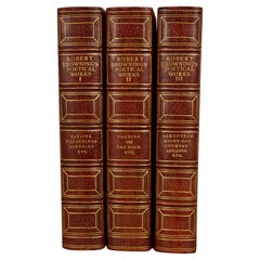
View AllThe Poetic and Dramatic Works of Robert Browning Bound in Leather and Cloth
Located in San Francisco, CA
An attractive leather bound set of the poetic and dramatic works of Robert Browning (1812-1889) published in 1906 by Houghton Mifflin and Company, New York and Boston. Top edges gilt...
Category
Early 20th Century American Books
Materials
Paper, Leather
All The Year Round by James Riley Woodcuts by Gustave Baumann
Located in San Francisco, CA
All the Year Round by James Whitcomb Riley with Woodcuts by Gustave Baumann. Published by Bobbs-Merrill, Indianapolis 1912. Nice copy including 12 lovely woodcuts by American painter...
Category
Early 20th Century American Books
Materials
Paper
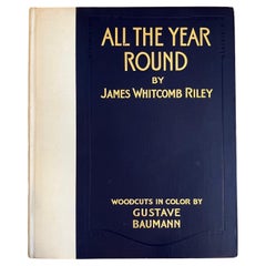
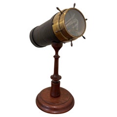
Table Parlor Kaleidoscope by C.G. Bush
Co., 1875
Located in San Francisco, CA
A scarce American kaleidoscope made and signed by Charles Bush consisting of a tubular barrel covered with pebbled paper with a cylindrical eye piece and a brass mounted chamber on t...
Category
Antique 1870s American Victorian Nautical Objects
Materials
Brass
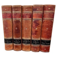
Beacon Lights of History by John Lord in 5 volumes
Located in San Francisco, CA
A five volume leather bound set titled "Beacon Lights of History" by John Lord
published in New York in 1884 by Fords, Howard and Hulbert profiling various historical luminaries from...
Category
Antique 1880s American Books
Materials
Leather, Paper
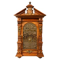
Walnut Neoclassical Style Table Cabinet with Mirrored Interior and Drawers
Located in San Francisco, CA
A very well-detailed figured walnut table cabinet in the neoclassical taste with an elaborate metal filigree door opening to reveal a beveled mirror above 2 small drawers, surmounted...
Category
Antique Late 19th Century European Victorian Architectural Models
Materials
Walnut, Mirror
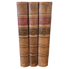
Europe During the Middle Ages by Henry Hallam 3 Volumes Leatherbound
Located in San Francisco, CA
Hallam's View of the State of Europe During the Middle Ages, complete in 3 leather bound octavo volumes with marbleized boards. The volumes contain the bookplate of former owner, Cha...
Category
Antique 1830s English Books
Materials
Leather, Paper
Still Thinking About These?
All Recently ViewedMore Ways To Browse
Antique Furniture California
Antique Pamphlets
19th Century Robinson
Pierre Cardin Assouline
Pierre Deux Book
R Dumont
Reginald Johnson
Rolling Stones Taschen Books
Romanov Jewels
Ryuji Tanaka
Sam Wagstaff
Schlumberger Rolex
Serge Roche Book
Sidney Paget
Steam Truck
Steven Gambrel Furniture
Tamotsu Yagi
The Life Of George Washington By John Marshall