Want more images or videos?
Request additional images or videos from the seller
1 of 11
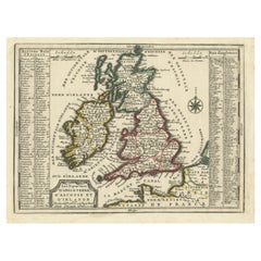
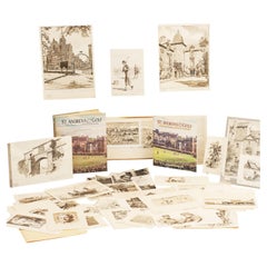
Golf Courses of the British Isles by Bernard Darwin
$1,297.97List Price
About the Item
- Dimensions:Height: 9.26 in (23.5 cm)Width: 7.88 in (20 cm)Depth: 2.17 in (5.5 cm)
- Style:Sporting Art (Of the Period)
- Place of Origin:
- Period:1910-1919
- Date of Manufacture:1910
- Condition:Minor fading.
- Seller Location:Oxfordshire, GB
- Reference Number:Seller: 272671stDibs: LU975712077023
About the Seller
5.0
Gold Seller
Premium sellers maintaining a 4.3+ rating and 24-hour response times
Established in 1977
1stDibs seller since 2013
835 sales on 1stDibs
Typical response time: 2 hours
Associations
LAPADA - The Association of Arts
Antiques Dealers
Authenticity Guarantee
In the unlikely event there’s an issue with an item’s authenticity, contact us within 1 year for a full refund. DetailsMoney-Back Guarantee
If your item is not as described, is damaged in transit, or does not arrive, contact us within 7 days for a full refund. Details24-Hour Cancellation
You have a 24-hour grace period in which to reconsider your purchase, with no questions asked.Vetted Professional Sellers
Our world-class sellers must adhere to strict standards for service and quality, maintaining the integrity of our listings.Price-Match Guarantee
If you find that a seller listed the same item for a lower price elsewhere, we’ll match it.Trusted Global Delivery
Our best-in-class carrier network provides specialized shipping options worldwide, including custom delivery.You May Also Like
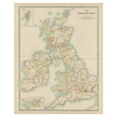
Antique Map of the British Isles by Balbi
1847
Located in Langweer, NL
Antique map titled 'Iles Britanniques'. Original antique map of the British Isles. This map originates from 'Abrégé de Géographie (..)' by Adrien Balbi. ...
Category
Antique Mid-19th Century Maps
Materials
Paper

Antique Map of the British Isles by Johnston
1909
Located in Langweer, NL
Antique map titled 'The British Isles'. Original antique map of the British Isles. With inset maps of the Shetland Islands, Chanel Islands, and London. T...
Category
Early 20th Century Maps
Materials
Paper
$237 Sale Price
20% Off
H 24.41 in W 19.49 in D 0.02 in
Antique Map of the British Isles by Delamarche, 1806
Located in Langweer, NL
Antique map titled 'Les Isles Britanniques.' Decorative map of the British Isles by Robert de Vaugondy, revised and published by Delamarche. Source unkno...
Category
Antique 19th Century Maps
Materials
Paper

$142 Sale Price
20% Off
H 11.3 in W 14.65 in D 0 in
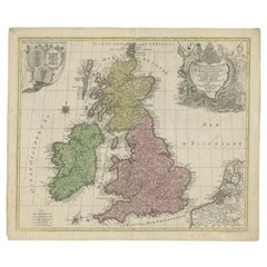
Antique Map of the British Isles by Lotter, 1764
Located in Langweer, NL
Antique map titled 'Le Grand Bretagne ou les Royaumes d'Angleterre et d'Ecosse'. Old engraved map of the British Isles (main islands United Kingdom & Ire...
Category
Antique 18th Century Maps
Materials
Paper
Antique Map of the British Isles by H. Chatelain, 1719
By Henri-Abraham Chatelain
Located in Langweer, NL
Beautiful hand colored large format map of the British Isles, with large insets of the Eastern and Western Hemispheres and the coats of arms for Engl...
Category
Antique Early 18th Century Maps
Materials
Paper

Antique Map of the Palaeontology of the British Isles by Johnston
1850
Located in Langweer, NL
Antique map titled 'Palaeontological Map of the British Islands'. Original antique map showing the palaeontology of the British Isles. This map originates from 'The Physical Atlas of...
Category
Antique Mid-19th Century Maps
Materials
Paper
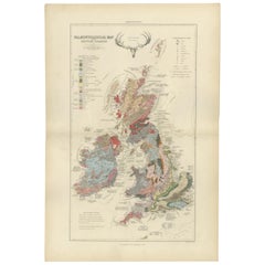
$427 Sale Price
20% Off
H 21.07 in W 14.18 in D 0.02 in
Original Antique Map of the British Isles Surrounded by Text
Located in Langweer, NL
Antique map titled 'Des Isles Britanniques'. Original antique map of the British isles. This map is divided in to three major regions of the 18th century United Kingdom: England, Ire...
Category
Antique Late 18th Century Maps
Materials
Paper

$351 Sale Price
20% Off
H 16.54 in W 23.71 in D 0.02 in
Antique Map of the British Isles by Covens
Mortier, 1730
By Covens
Mortier
Located in Langweer, NL
Covens and Mortier's attractive double-page engraved map of the British Isles, based on the 1702 De L'Isle map. The map features a large car...
Category
Antique Mid-18th Century Maps
Materials
Paper
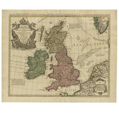
$617 Sale Price
20% Off
H 20.87 in W 25.79 in D 0.02 in
Antique Map of the Ancient British Isles by Janssonius, circa 1640
Located in Langweer, NL
Antique map titled 'Insularum Britannicarum Acurata Delineatio'. Original antique map of the ancient British Isles. England and Wales are labelled as B...
Category
Antique Mid-17th Century Dutch Maps
Materials
Paper

$1,127
H 19.89 in W 23.23 in D 0.02 in
Map of the British Isles with Historical Kings, 1719
Located in Langweer, NL
This antique map, titled "Les Royaumes d'Angleterre d'Escosse et d'Irlande," offers a detailed view of the British Isles, including England, Wales, Scotland, and Ireland. Additionall...
Category
Antique Early 18th Century Maps
Materials
Paper
$417 Sale Price
20% Off
H 7.64 in W 9.93 in D 0.02 in
More From This Seller
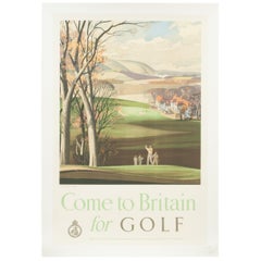
View AllVintage Golf Print, Come to Britain for Golf by Roland Hilder
Located in Oxfordshire, GB
Vintage golfing travel poster, 'Come to Britain for Golf' by Roland Hilder.
A striking golfing poster by Rowland Hilder entitled 'Come to Bri...
Category
Vintage 1950s British Sporting Art Sports Equipment and Memorabilia
Materials
Paper
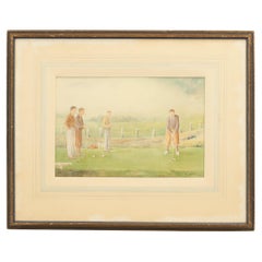
Golf Watercolour Painting Of Members, Bilston Golf Club
Located in Oxfordshire, GB
Bilston Golf Club Watercolour, H.E. Lewis Driving.
A charming golf watercolour of H. Lewis (the club professional at Bilston Golf Club) driving from th...
Category
Vintage 1930s English Sporting Art Paintings
Materials
Paper, Wood
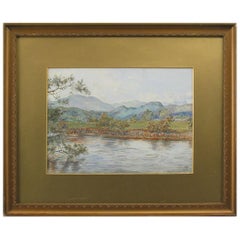
Golf Watercolor Painting "On the Feish" Perthshire by V. Astley
Located in Oxfordshire, GB
A charming watercolor of golfers on the golf course, possibly at Callander, with Ben Ledi beyond. This view typifies the glorious scenery of "Rob Roy Country"...
Category
Early 20th Century British Sporting Art Paintings
Materials
Paper
Collection of Original Golf Artwork by Arthur Weaver
By Arthur Weaver
Located in Oxfordshire, GB
Golf, Collection of Original Artwork by Arthur Weaver.
A large collection of original artwork for the Morton & John Olman book "St. Andrews & Golf". It includes the concept for the d...
Category
Early 2000s English Sporting Art Sports Equipment and Memorabilia
Materials
Paper
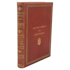
British Sports And Sportsmen, The story Of Shipping
Located in Oxfordshire, GB
British Sports & Sportsmen Book, The Story Of Shipping.
A rare, first edition, single encyclopaedia of sports book from the series "British Sports and Sportsmen" titled The Story Of ...
Category
Early 20th Century British Sporting Art Sports Equipment and Memorabilia
Materials
Leather
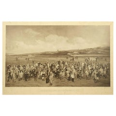
Antique Golf Print, Royal North Devon Golf Club, Photogravure of Westward Ho
Located in Oxfordshire, GB
Royal North Devon Golf Club 1893 by Mayall & Co. Ltd.
A great image of the members of the 'Royal North Devon Golf Club, Westward Ho!' from 1893. The figures are all photographs superimposed onto a painted background of the course. In the margin is printed 'Permanent Autotype, Produced by Mayall & Co. Ltd. 73 Piccadilly'. The image appears very much photographic but is more of a photomechanical print rather than a photograph.
John Jabez Edwin Paisley Mayall (1813-1901) was an English photographer who in 1860 took the first carte-de-visite photographs of Queen Victoria.
Taken from Royal North Devon:-
Royal North Devon at Westward Ho! Can rightly claim to be the cradle of English Golf. Founded in 1864, it is the oldest golf course in the country and is regarded as the St Andrews of the South. The golf course is as tough as any of the UK's more famous links layouts and has recently been placed in Golf World 's 'Top 100 Courses in the World' that a golfer 'must play'.
Not only is Royal North Devon a great course, it is also a place of huge historical importance. Inside the warmly welcoming clubhouse, the golf museum, honours boards and the clubs top competition trophies are worth a visit on their own and help to tell the story of the game and this remarkable club's unique place in it.
Above all, this is great, natural golf that is largely unchanged from 100 years ago when Harold Hilton et al pronounced Westward Ho! As England's No 1 competition golf course. RND is pure, raw exhilaration and ultimately the experience of playing a fast running links in a stiff breeze still tests the very best in the game.
Many of the great players of the last 100 years were regular competitors at RND but the greatest of them all is without doubt John Henry Taylor...
Category
Antique 1890s British Sporting Art Sports Equipment and Memorabilia
Materials
Paper
Still Thinking About These?
All Recently ViewedMore Ways To Browse
Antique Collection Of Italian Grand Tour Plaster Intaglios
English Leather Bound Books
John Keats
Jean Royere Book
Antique Collection Of Italian Grand Tour Plaster Intaglios
Scott Williams
Walt Peregoy
Scott Williams
Walt Peregoy
Scott Williams
Walt Peregoy
Ruth Reeves
Ruth Reeves
Frank Lloyd Wright On Sale
Antique Library Books
Andre Frechet
Silver Book Cover
Antique Collection Of Italian Grand Tour Plaster Intaglios