Items Similar to VOC Atlas of Africa and East Indies by J.W. Heydt, Homann Heirs, 1744


Want more images or videos?
Request additional images or videos from the seller
1 of 12
VOC Atlas of Africa and East Indies by J.W. Heydt, Homann Heirs, 1744
$16,079.43
£11,915.87
€13,400
CA$21,975.87
A$23,922.53
CHF 12,698.09
MX$287,839.53
NOK 160,902.06
SEK 147,431.75
DKK 102,071.80
About the Item
VOC Atlas of Africa and East Indies by J.W. Heydt, Homann Heirs, 1744
An important and richly illustrated 18th-century work documenting the Dutch East India Company’s global reach, 'Allerneuester Geographisch- und Topographischer Schau-Platz von Africa und Ost-Indien' was published in Nuremberg by Homann’s Heirs in 1744. Compiled and illustrated by Johann Wolfgang Heydt (1702–1750), the volume presents one of the most complete visual records of the VOC’s settlements, trade posts, and coastal territories across Asia and Africa.
Heydt, a German artist, architect, and surveyor, sailed to the East Indies as a VOC engineer, working in Ceylon, India, and Batavia (Jakarta). His firsthand observations formed the basis of this remarkable work. The atlas contains 116 engraved plates—maps, coastal profiles, city plans, and views—alongside detailed descriptive text. These include maps of the Indian Ocean, the coasts of Africa and Asia, and numerous Dutch settlements such as Batavia, Cochin, Ceylon, the Cape of Good Hope, and Nagasaki. Many engravings are based directly on Heydt’s original drawings, executed by A. Hoffer and others, offering a vivid glimpse into 18th-century trade, geography, and colonial architecture.
Published by the renowned cartographic house of Homann’s Erben, the work stands as both a geographical and artistic achievement, combining scientific accuracy with decorative baroque engraving. It is considered one of the principal German sources on VOC activities, complementing the great Dutch atlases of the period.
This copy retains 116 plates (lacking only the frontispiece and second title, as often the case) and remains in a contemporary full vellum binding. The engravings are sharp and well-printed, showing scenes of ships, fortresses, native peoples, and harbors from the Cape of Good Hope to Japan.
Condition report:
A well-preserved example with some light foxing and mild soiling consistent with age. Small restored hole in the title page, minor toning near edges, and occasional faint spotting. Binding in contemporary vellum, slightly rubbed and stained but structurally sound. Overall a very good copy of this monumental VOC work.
Framing tips:
Individual engravings from this volume, particularly those depicting Batavia, Ceylon, or the Cape, present beautifully when framed. They suit neutral or warm-toned mats (ivory, beige, or light ochre) and dark wooden or gilt frames to enhance the baroque linework.
Technique: Engraving on laid paper
Maker: Johann Wolfgang Heydt, published by Homann’s Heirs, Nuremberg, 1744
- Dimensions:Height: 12.8 in (32.5 cm)Width: 14.38 in (36.5 cm)Depth: 1.97 in (5 cm)
- Materials and Techniques:Paper,Engraved
- Place of Origin:
- Period:
- Date of Manufacture:1744
- Condition:A well-preserved example with some light foxing and mild soiling consistent with age. Small restored hole in the title page, minor toning near edges, and occasional faint spotting. Binding in contemporary vellum, slightly rubbed.
- Seller Location:Langweer, NL
- Reference Number:Seller: BG-141031stDibs: LU3054346922252
About the Seller
5.0
Recognized Seller
These prestigious sellers are industry leaders and represent the highest echelon for item quality and design.
Platinum Seller
Premium sellers with a 4.7+ rating and 24-hour response times
Established in 2009
1stDibs seller since 2017
2,819 sales on 1stDibs
Typical response time: 1 hour
- ShippingRetrieving quote...Shipping from: Langweer, Netherlands
- Return Policy
More From This Seller
View AllCharting the Course of Empire: Bonne
s 1770 Masterpiece Maps of the Indian Ocean
Located in Langweer, NL
A voyage through history with an exquisite collection of Rigobert Bonne's 1770 maps, as featured in the coveted Atlas Moderne circa 1770. Each map, a cartographic treasure, captures ...
Category
Antique 1770s Maps
Materials
Paper

$470 Sale Price / set
20% Off
Free Shipping
Views of Saunders, Osnaburg, Boscawens, Admiral Keppel
s
Wallis Island, c.1774
Located in Langweer, NL
Antique print titled 'Isles de Sir Charles Saunder Latitude (..)'.
Coastal views of Sir Charles Saunders Island ; Osnaburg Island [Mehetia, in French Polynesia] ; Boscawens Islan...
Category
Antique 1770s Maps
Materials
Paper
$393 Sale Price
20% Off
Antique Map of the Maluku Islands by Van der Aa, 1714
By Pieter Van Der Aa
Located in Langweer, NL
Antique Map Moluccas titled 'Les Isles Moluques'. Rare map of the Spice Islands made after a map engraved by Pieter van den Keere and published in the 1628 edition of the Mercator At...
Category
Antique 18th Century Maps
Materials
Paper

Antique Map of the Northern Coast of Africa and Southern Europe, circa 1745
By Covens
Mortier
Located in Langweer, NL
Antique map titled 'In Notitiam Ecclesiasticam Africae Tabula Geographica'. Very decorative hand-colored map of the northern coast of Africa, Spain, Italy and the Mediterranean with the islands of Sardinia, Corsica, Majorca, Minorca etc. Sicily features a smoking Mount Aetna. Embellished with three architectural cartouches...
Category
Antique Mid-18th Century Maps
Materials
Paper

$314 Sale Price
67% Off
Original Antique Map of Northern Africa by Van Dùren (1749)
Located in Langweer, NL
This is a German antique map titled 'Neue Geographische Vorstellung der Mitternaechtlichen Küste von Africa'. Original antique engraving of Northern Africa extending from the Strait ...
Category
Antique Mid-18th Century Maps
Materials
Paper

$335 Sale Price
20% Off
Original Antique Map of Egypt by Van Dùren
1749
Located in Langweer, NL
Decorative German antique engraving with titled 'Neue Vorstellung von Aegypten (..)'. It concerns a rare original antique map of Egypt. This map o...
Category
Antique Mid-18th Century Maps
Materials
Paper

$247 Sale Price
25% Off
You May Also Like
West Coast of Africa, Guinea
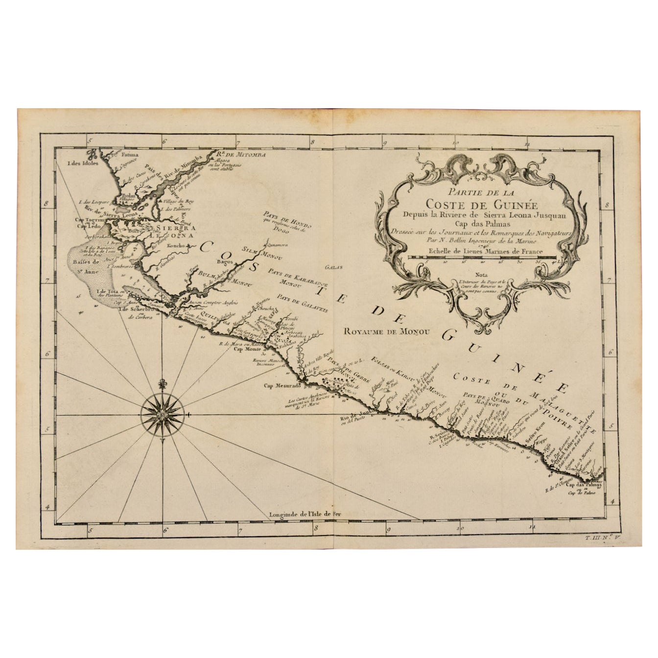
Sierra Leone: An 18th Century Map by Bellin
By Jacques-Nicolas Bellin
Located in Alamo, CA
Jacques Bellin's copper-plate map entitled "Partie de la Coste de Guinee Dupuis la Riviere de Sierra Leona Jusquau Cap das Palmas", depicting the coast of Guinea and Sierra Leone in ...
Category
Antique Mid-18th Century French Maps
Materials
Paper

$460 Sale Price
20% Off
1627 Hendrik Hondius Map Entitled "Vltoniae Orientalis Pars, " Ric.a009
Located in Norton, MA
1627 Hendrik Hondius map entitled
"Vltoniae orientalis pars,"
Ric.a009
Title:
Vltoniae orientalis : pars
Title (alt.) :
Ultoniae orientalis pars
Creator:
Mercator, Gerh...
Category
Antique 17th Century Dutch Maps
Materials
Paper

Africa: A Large 17th Century Hand-Colored Map by Sanson and Jaillot
By Nicolas Sanson
Located in Alamo, CA
This large original hand-colored copperplate engraved map of Africa entitled "L'Afrique divisee suivant l'estendue de ses principales parties ou sont distingues les uns des autres, L...
Category
Antique 1690s French Maps
Materials
Paper

$1,740 Sale Price
20% Off
Antique French Map of Asia Including China Indoneseia India, 1783
Located in Amsterdam, Noord Holland
Very nice map of Asia. 1783 Dedie au Roy.
Additional information:
Country of Manufacturing: Europe
Period: 18th century Qing (1661 - 1912)
Condition: Overall Condition B (Good Used)...
Category
Antique 18th Century European Maps
Materials
Paper

$486 Sale Price
40% Off
West Africa Entitled "Guinea Propria": An 18th Century Hand Colored Homann Map
By Johann Baptist Homann
Located in Alamo, CA
This is a scarce richly hand colored copper plate engraved map of Africa entitled "Guinea Propria, nec non Nigritiae vel Terrae Nigrorum Maxima Pars" by Johann Baptist Homann (1664-1...
Category
Antique Mid-18th Century German Maps
Materials
Paper

$1,500 Sale Price
20% Off
California, Alaska and Mexico: 18th Century Hand-Colored Map by de Vaugondy
By Didier Robert de Vaugondy
Located in Alamo, CA
This is an 18th century hand-colored map of the western portions of North America entitled "Carte de la Californie et des Pays Nord-Ouest separés de l'Asie par le détroit d'Anian, ex...
Category
Antique 1770s French Maps
Materials
Paper
