Video Loading
1 of 3
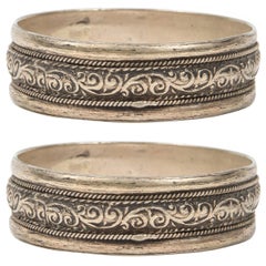
A pair of silver fibulae from the Atlas Mountains of Morocco
$648.48List Price
About the Item
- Dimensions:Height: 11.5 in (29.21 cm)Width: 94 in (238.76 cm)Depth: 3 in (7.62 cm)
- Materials and Techniques:
- Place of Origin:
- Period:
- Date of Manufacture:Early 20th century
- Condition:Wear consistent with age and use.
- Seller Location:Amsterdam, NL
- Reference Number:1stDibs: LU5458242189922
Authenticity Guarantee
In the unlikely event there’s an issue with an item’s authenticity, contact us within 1 year for a full refund. DetailsMoney-Back Guarantee
If your item is not as described, is damaged in transit, or does not arrive, contact us within 7 days for a full refund. Details24-Hour Cancellation
You have a 24-hour grace period in which to reconsider your purchase, with no questions asked.Vetted Professional Sellers
Our world-class sellers must adhere to strict standards for service and quality, maintaining the integrity of our listings.Price-Match Guarantee
If you find that a seller listed the same item for a lower price elsewhere, we’ll match it.Trusted Global Delivery
Our best-in-class carrier network provides specialized shipping options worldwide, including custom delivery.You May Also Like
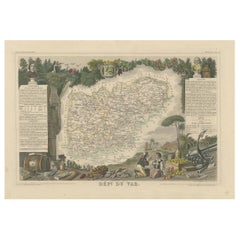
The Illustrated Map of the Var Department from the Atlas National Illustré, 1856
Located in Langweer, NL
This original hand-colored map is from the "Atlas National Illustré," a work by Victor Levasseur, a French geographer and cartographer known for his richly illustrated maps.
The map...
Category
Antique 1850s Maps
Materials
Paper
$326 Sale Price
20% Off
H 14.18 in W 20.87 in D 0 in
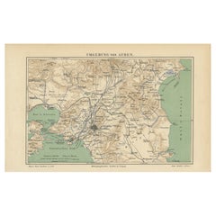
Antique Map of the Region of Athens from a German Atlas of 1893
Located in Langweer, NL
Antique map titled 'Umgebung von Athen'. Original antique map of the region of Athens, Greece. This map originates from the 5th edition of 'Meyers Konversations-Lexikon', published 1...
Category
Antique 19th Century Maps
Materials
Paper
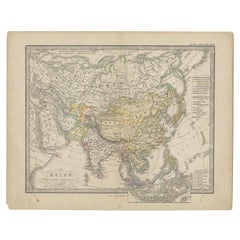
Antique Map of the Asian Continent from a German School Atlas, 1862
Located in Langweer, NL
Antique map titled 'Asien Politische Ubersicht'. Old map of the Asian continent. Originates from Stieler's 'Schul-Atlas'.
Artists and Engravers: Published by Johan Georg Justus Per...
Category
Antique 19th Century Maps
Materials
Paper
Pair of Moroccan Berber Ethnic Silver Bracelets
By Berber Tribes of Morocco
Located in Moreno Valley, CA
Pair of Moroccan Berber Tribal bracelets.
Moroccan Tribal bracelets from the High Atlas of Morocco.
Handcrafted by Berber women using Moroccan silver nickel.
The ethnic Nomadic and Bedouin jewelry...
Category
20th Century Moroccan Tribal Tribal Art
Materials
Metal, Silver
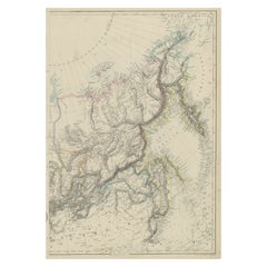
Old Map of Russia Originating from the
Weekly Dispatch Atlas
, ca.1865
Located in Langweer, NL
Antique map titled 'Russia in Asia, E Sheet'.
Old map of Russia originating from the 'Weekly Dispatch Atlas'.
Artists and Engravers: Engraved by J.W. Lowry.
Category
Antique 1860s Maps
Materials
Paper
$172 Sale Price
20% Off
H 19.3 in W 13.39 in D 0 in
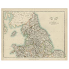
Original Antique Map of England and Wales from the 1909 Royal Atlas
Located in Langweer, NL
The antique map titled 'England and Wales' is a historical cartographic representation of these two nations. This original antique map of England...
Category
Early 20th Century Maps
Materials
Paper
$240 Sale Price
20% Off
H 19.49 in W 24.41 in D 0.02 in
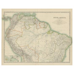
Exploring South America
s North: Antique Map from the Royal Atlas of 1909
Located in Langweer, NL
The antique map titled 'South America, Northern Sheet' is a historical cartographic representation of the northern part of South America. This original antique map features inset map...
Category
Early 20th Century Maps
Materials
Paper
$240 Sale Price
20% Off
H 19.49 in W 24.41 in D 0.02 in
Map of Ireland: Early 19th Century - from the 1802 Tardieu Atlas
Located in Langweer, NL
Antique Map Description
**Title:** Carte d'Irlande
**Publication Details:**
- **Atlas Title:** Nouvel Atlas Universel de Géographie Ancienne et Moderne
- **Purpose:** For the Nouve...
Category
Antique Early 1800s Maps
Materials
Paper

$422 Sale Price
20% Off
H 16.23 in W 22.25 in D 0.01 in
Political Map of Europe: Early 19th Century, from the 1802 Tardieu Atlas
Located in Langweer, NL
Antique Map Description
Title: Carte Générale et Politique de l'Europe
Publication Details:
- **Atlas Title:** Nouvel Atlas Universel de Géographie Ancienne et Moderne
- **Purpose...
Category
Antique Early 1800s French Maps
Materials
Paper

$461 Sale Price
20% Off
H 16.3 in W 22.41 in D 0.01 in
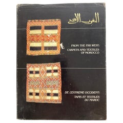
From the Far West Carpets and Textiles of Morocco Hardcover Book
By Berber Tribes of Morocco
Located in Moreno Valley, CA
From the Far West Carpets and Textiles of Morocco
Fiske, Patricia L. and Pickering, W. Russell and Yohe, Ralph S.
in black cloth covered board ...
Category
Vintage 1980s Moroccan Modern Books
Materials
Paper
Still Thinking About These?
All Recently ViewedMore Ways To Browse
Antique Atlas Furniture
African Costume
Ovchinnikov Kovsh
Percossi Papi
Roy Rogers Boots
Silver And Turquoise Watch
Siv Lagerstrom
Swiss Enamel Pocket Watches
Tasco Silver
Tibetan Necklaces
Victorian Silver Book Chain
Victorian Tiger Claw
Vintage 14k Gold Eyeglasses
Vintage Amber Necklace Vintage Costume Jewellery
Vintage Bell Trading Post Rings
Wenger 16999
Wiener Werkstatte Brooch
Zentra Watch