Video Loading
1 of 12
Antique Leitz Wetzlar Slide Projection Machine
$474.40List Price
About the Item
- Creator:Ernst Leitz Wetzlar (Maker)
- Dimensions:Height: 6.7 in (17 cm)Width: 18.51 in (47 cm)Depth: 10.63 in (27 cm)
- Style:Mid-Century Modern (Of the Period)
- Materials and Techniques:
- Place of Origin:
- Period:
- Date of Manufacture:Unknown
- Condition:Wear consistent with age and use.
- Seller Location:Lisboa, PT
- Reference Number:Seller: S/ Refª1stDibs: LU4727244601102
Authenticity Guarantee
In the unlikely event there’s an issue with an item’s authenticity, contact us within 1 year for a full refund. DetailsMoney-Back Guarantee
If your item is not as described, is damaged in transit, or does not arrive, contact us within 7 days for a full refund. Details24-Hour Cancellation
You have a 24-hour grace period in which to reconsider your purchase, with no questions asked.Vetted Professional Sellers
Our world-class sellers must adhere to strict standards for service and quality, maintaining the integrity of our listings.Price-Match Guarantee
If you find that a seller listed the same item for a lower price elsewhere, we’ll match it.Trusted Global Delivery
Our best-in-class carrier network provides specialized shipping options worldwide, including custom delivery.You May Also Like
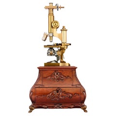
Leitz Brass Compound Microscope
By E. Leitz
Located in New Orleans, LA
Brass Compound Microscope in Case
Ernst Leitz
Dated 1897
This rare late 19th-century compound microscope was crafted by the renowned optical firm Ernst Leitz GmbH of Wetzlar, German...
Category
Antique 19th Century Scientific Instruments
Materials
Optical Glass, Wood
Antique Microscope by W. Klein Wetzlar with Carl Zeiss optical lenses, Germany
Located in Beograd, RS
In this listing you will find a rare antique Microscope manufactured by W. Klein in Wetzlar. The microscope features a solid brass body that has dev...
Category
Antique Early 1900s German Industrial Scientific Instruments
Materials
Brass
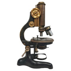
$2,371
H 11.42 in W 4.73 in D 7.09 in
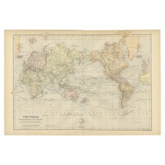
Antique Mercator Projection World Map by Petri, c.1873
Located in Langweer, NL
Antique world map titled 'Wereldkaart naar Mercator's Projectie'. Old map of the world. This map originates from 'School-Atlas van alle Deelen der Aarde'.
Artists and engravers: ...
Category
Antique 19th Century Maps
Materials
Paper

Antique Map of the World on Mercator
s Projection, 1788
Located in Langweer, NL
Antique map titled 'Kaart van de Geheele Wereld (..)'. Uncommon small world map on Mercator's projection. Nice detail of the islands throughout the wor...
Category
Antique Late 18th Century Maps
Materials
Paper

$711 Sale Price
20% Off
H 8.08 in W 12.8 in D 0.02 in
Antique Map of the World, Mercator Projection, by Wyld,
1845
Located in Langweer, NL
Antique map titled 'The World'. Original antique world map, on Mercator's projection. This map originates from 'An Atlas of the World, Compr...
Category
Antique Mid-19th Century Maps
Materials
Paper

$332 Sale Price
20% Off
H 10.24 in W 14.18 in D 0.02 in
1884 Antique Decorative World Map – Mercator Projection, Victorian Era Print
Located in Langweer, NL
Antique World Map on Mercator’s Projection – Black’s Atlas, 1884
This finely engraved and colored map, titled The World on Mercator’s Projection, was published in the New and Revise...
Category
Antique 1880s Scottish Maps
Materials
Paper

$426
H 17.84 in W 24.1 in D 0.01 in
Antique Narragansett Machine Company Forearm Exercise Machine , 1920s, USA
Located in San Francisco, CA
Collectible Antique Narragansett Machine Company Forearm Exercise Machine is constructed of wood and iron. To operate, one merely turns the grip in different directions to engage dif...
Category
Vintage 1920s American Sports Equipment and Memorabilia
Materials
Iron
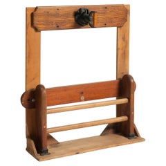
$1,920
H 42.5 in W 40 in D 10.25 in
Antique Map of the World on Mercator Projection by Anson, 1749
Located in Langweer, NL
Antique map titled 'Nieuwe Wereld Kaart waar in de Reizen van den Hr. Anson rondsom de Wereld'. Original antique map of the world on Mercator'...
Category
Antique 18th Century Maps
Materials
Paper

$279 Sale Price
51% Off
H 10.63 in W 16.74 in D 0 in
Antique Map of The World in Hemispheres on Various Projections, 1882
Located in Langweer, NL
This stunning 1882 'Antique Map of The World in Hemispheres' showcases an exquisite blend of cartographic precision and artistic elegance. Crafted under the watchful eye of W.G. Blac...
Category
Antique 1880s Maps
Materials
Paper

$265 Sale Price
20% Off
H 14.97 in W 22.25 in D 0 in
Colorful Detailed Antique Map of The World on Mercators Projection, 1882
Located in Langweer, NL
The 'World of Mercator's Projection' is a map with a stunning portrayal of global geography and maritime navigation from an era steeped in exploration and discovery. With meticulous detail and precision, this map showcases the world's continents on Mercator's famous projection, capturing the essence of a bygone era's cartographic expertise.
Illustrating the courses of chief ocean currents and key navigation tracks between major ports, this map doesn't just depict landmasses but also reveals the vital maritime routes that shaped global trade and exploration. Each line and curve represents the pathways of ancient voyages and modern seafaring, connecting distant shores and continents.
Crafted with the precision characteristic of Mercator's projection, this map offers a unique perspective on how sailors and explorers navigated the world's vast oceans. It stands as a testament to the artistry and scientific ingenuity of cartographers of that time, showcasing their commitment to accurate representation amid the challenges of mapping a spherical world on a flat surface.
This map isn't just a historical document; it's a captivating piece of cartographic art...
Category
Antique 1880s Maps
Materials
Paper
$237 Sale Price
20% Off
H 14.97 in W 22.45 in D 0 in
Still Thinking About These?
All Recently ViewedMore Ways To Browse
Vintage Projectors
Leitz Vintage
Slide Projector
Vintage Slide Projectors
John Adams President
Police Memorabilia
Shell Casing Trench Art
Space Age Tv
T C F Co Antique Furniture
Texas Republic
Vintage Oil Can
Wine Memorabilia
Antique Barber Collectibles
Antique Ford Model T
Antique Glass Christmas Tree Toppers
Antique Magic Lantern Glass Slide
Bell Telephone System
Judges Gavel