Want more images or videos?
Request additional images or videos from the seller
1 of 12
Civil War Bible, Presented to James Robberts, of 1st Maryland Vol. Group, 1864
Price:$4,400
$5,000List Price
About the Item
- Dimensions:Height: 5.94 in (15.09 cm)Width: 4.13 in (10.5 cm)Depth: 1.5 in (3.81 cm)
- Materials and Techniques:
- Place of Origin:
- Period:
- Date of Manufacture:1864
- Condition:Additions or alterations made to the original: New archival clamshell by Felton Bookbinding Ltd. in Ontario, Canada in November of 2024. Repaired: Archivally rebacked and light restoration work by Felton Bookbinding Ltd. in Ontario, Canada in November of 2024. Wear consistent with age and use. Minor losses. Minor structural damages. Minor fading.
- Seller Location:Colorado Springs, CO
- Reference Number:Seller: BK11361stDibs: LU909742794392
About the Seller
4.9
Platinum Seller
Premium sellers with a 4.7+ rating and 24-hour response times
Established in 2010
1stDibs seller since 2011
473 sales on 1stDibs
Typical response time: 4 hours
Authenticity Guarantee
In the unlikely event there’s an issue with an item’s authenticity, contact us within 1 year for a full refund. DetailsMoney-Back Guarantee
If your item is not as described, is damaged in transit, or does not arrive, contact us within 7 days for a full refund. Details24-Hour Cancellation
You have a 24-hour grace period in which to reconsider your purchase, with no questions asked.Vetted Professional Sellers
Our world-class sellers must adhere to strict standards for service and quality, maintaining the integrity of our listings.Price-Match Guarantee
If you find that a seller listed the same item for a lower price elsewhere, we’ll match it.Trusted Global Delivery
Our best-in-class carrier network provides specialized shipping options worldwide, including custom delivery.You May Also Like
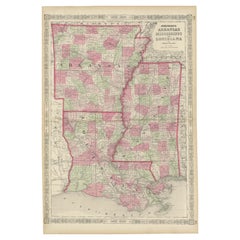
Rare 1864 Civil War Era Map of Arkansas, Mississippi, and Louisiana
Located in Langweer, NL
Title: Rare 1864 Civil War Era Map of Arkansas, Mississippi, and Louisiana
Description: This captivating antique map, titled "Johnson's Arkansas, Mississippi, and Louisiana," was pu...
Category
Antique 1860s Maps
Materials
Paper
Rare 1864 Civil War Era Map of Massachusetts, Connecticut, and Rhode Island
Located in Langweer, NL
Title: Rare 1864 Civil War Era Map of Massachusetts, Connecticut, and Rhode Island
Description: This exquisite antique map, titled "Johnson's Massachusetts, Connecticut, and Rhode I...
Category
Antique 1860s Maps
Materials
Paper
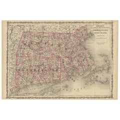
$428
H 18 in W 26.38 in D 0.01 in
Decorative 1864 Civil War Era Map of Indiana with Lake Michigan Detail
Located in Langweer, NL
Title: Rare 1864 Civil War Era Map of Indiana with Lake Michigan Detail
Description: This finely detailed antique map, titled "Johnson's Indiana," was published in 1864 by Johnson a...
Category
Antique 1860s Maps
Materials
Paper

$405
H 26.38 in W 18 in D 0.01 in
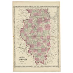
Rare 1864 Civil War Era Map of Illinois with Lake Michigan Detail
Located in Langweer, NL
Title: Rare 1864 Civil War Era Map of Illinois with Lake Michigan Detail
Description: This intricately detailed antique map, titled "Johnson's Illinois," was published in 1864 by Jo...
Category
Antique 1860s Maps
Materials
Paper
Historic 1864 Civil War Map of Georgia and Alabama with Coastal Focus
Located in Langweer, NL
Title: Historic 1864 Civil War Map of Georgia and Alabama with Coastal Focus
Description: This intricately detailed antique map, titled "Johnson's Georgia and Alabama," was publishe...
Category
Antique 1860s Maps
Materials
Paper
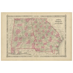
$405
H 18 in W 26.38 in D 0.01 in
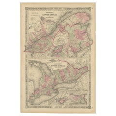
Historic 1864 Civil War Era Map of Canada with Great Lakes Detail
Located in Langweer, NL
Title: Rare 1864 Civil War Era Map of Canada with Great Lakes Detail
Description: This finely detailed antique map, titled "Johnson's Canada," was published in 1864 by Johnson and W...
Category
Antique 1860s Maps
Materials
Paper
Catalogue of English Furniture and Woodwork, Vol. III
Vol IV, 1st Ed
By Victoria and Albert Museum
Located in valatie, NY
Catalogue of English Furniture and Woodwork, Vol. III and IV. Vol III, Late Stuart to Queen Anne by Oliver Brackett. Pair of 1st Ed hardcovers. Published by Victoria and Albert Museu...
Category
Early 20th Century English Books
Materials
Paper

Civil War Era Map of Kentucky and Tennessee with Scenic Insets, Published 1864
Located in Langweer, NL
Rare 1864 Civil War Era Map of Kentucky and Tennessee with Scenic Insets
Description: This stunning antique map, titled "Johnson's Kentucky and Tennessee," was published in 1864 by ...
Category
Antique 1860s Maps
Materials
Paper
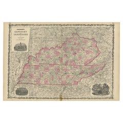
$405
H 18 in W 26.38 in D 0.01 in
Historic 1864 Civil War Map of Pennsylvania and New Jersey with Coastal Focus
Located in Langweer, NL
Title: Historic 1864 Civil War Map of Pennsylvania and New Jersey with Coastal Focus
Description: This meticulously crafted antique map, titled "Johnson's Pennsylvania and New Jerse...
Category
Antique 1860s Maps
Materials
Paper
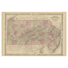
$405
H 18 in W 26.38 in D 0.01 in
3 Vol. Robert Tomes, MD., and Benjamin G. Smith, The Great Civil War
Located in New York, NY
3 Vol. Robert Tomes, MD., and Benjamin G. Smith, The Great Civil War: A History of the Late Rebellion. Illustrated throughout with biographical sketches of leading statesmen, disting...
Category
Antique 19th Century American Books
Materials
Leather

$1,750 / set
H 2.125 in W 9.25 in D 11.5 in
More From This Seller
View AllThe Indian Tribes of North America by Thomas McKenney and James Hall, 3 Vols.
By McKenney
Hall
Located in Colorado Springs, CO
McKenney, Thomas L. and James Hall. The Indian Tribes of North America. With Biographical Sketches and Anecdotes of The Principal Chiefs. Edinburgh: John Grant, 1933-4. A New Edition...
Category
Vintage 1930s Scottish Books
Materials
Fabric, Paper

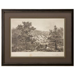
"Army of the Potomac" by John Bachelder, Civil War Era Lithograph, circa 1863
Located in Colorado Springs, CO
Fully-entitled: Army of the Potomac. The Wagon Trains of the Army of the Potomac en Route from Chickahominy to James River VA. During the Seven...
Category
Antique 19th Century American Prints
Materials
Paper
My Experiences in the World War, by John Pershing, First Edition, Two Vols, 1931
Located in Colorado Springs, CO
Pershing, John J. My Experiences in the World War. New York: Frederick A. Stokes Company, 1931. First Edition. Two Volume Set. Rebound in 1/4 leather and cloth boards, with raised ba...
Category
Vintage 1930s American Mid-Century Modern Books
Materials
Leather, Fabric, Paper

1864 Map of North America, Antique Hand-Colored Map, by Adolphe Hippolyte Dufour
Located in Colorado Springs, CO
Offered is a map of North America entitled Amerique du Nord from 1864. This rare, separately published wall map was produced by Adolphe Hippolyte Dufour. This map includes vibrant an...
Category
Antique 1860s French Maps
Materials
Paper

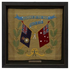
Souvenir of the War 1914-15-16-17-18 Banner
Located in Colorado Springs, CO
Presented is a stunning textile banner from the first World War, dating to 1918. The square tan cotton cloth is embroidered with two crossed flags, the ...
Category
Vintage 1910s Australian Political and Patriotic Memorabilia
Materials
Cotton
Lee
s Lieutenants by Douglas Southhall Freeman, Three Vols., First Edition, 1942
Located in Colorado Springs, CO
Freeman, Douglas Southall. Lee’s Lieutenants: A Study in Command. New York: Charles Scribner’s Sons, 1942. First edition. Three volume set. Rebound in ¼ black leather and cloth, with raised bands, gilt tooling and titles to the spine, and an archival slipcase.
Presented is a first edition, three volume set of Lee’s Lieutenants by Douglas Southall Freeman...
Category
Vintage 1940s American Books
Materials
Leather, Paper

Still Thinking About These?
All Recently ViewedMore Ways To Browse
Scottish Coat Of Arms
Train Memorabilia
Trench Art Ww1
Used Vornado Fan
Vintage Card Display
Vornado Fan
Antique Beer Memorabilia
Antique Cowboy Collectibles
Antique Fire Alarm
Antique Masonic Collectables
Christmas Tree Topper
Historical Flask
John Adams President
Police Memorabilia
Shell Casing Trench Art
Space Age Tv
T C F Co Antique Furniture
Texas Republic