1 of 6
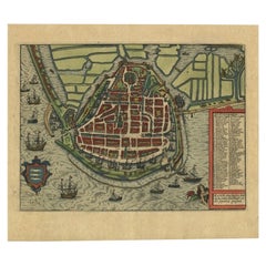
Copper Topographical Map Printing Plate of Winchester, VA
$895List Price
About the Item
- Dimensions:Height: 19.5 in (49.53 cm)Width: 16 in (40.64 cm)Depth: 0.07 in (1.78 mm)
- Style:Other (Of the Period)
- Materials and Techniques:
- Place of Origin:
- Period:
- Date of Manufacture:circa 1890s
- Condition:Wear consistent with age and use.
- Seller Location:Cookeville, TN
- Reference Number:Seller: JB1335B1stDibs: LU234437921733
Authenticity Guarantee
In the unlikely event there’s an issue with an item’s authenticity, contact us within 1 year for a full refund. DetailsMoney-Back Guarantee
If your item is not as described, is damaged in transit, or does not arrive, contact us within 7 days for a full refund. Details24-Hour Cancellation
You have a 24-hour grace period in which to reconsider your purchase, with no questions asked.Vetted Professional Sellers
Our world-class sellers must adhere to strict standards for service and quality, maintaining the integrity of our listings.Price-Match Guarantee
If you find that a seller listed the same item for a lower price elsewhere, we’ll match it.Trusted Global Delivery
Our best-in-class carrier network provides specialized shipping options worldwide, including custom delivery.You May Also Like
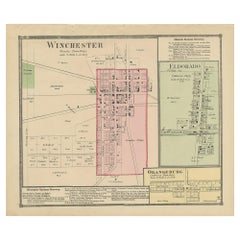
Antique Map of Winchester, Eldorado
Orangeburg, 1871
Located in Langweer, NL
Antique map titled 'Winchester, Eldorado, Orangeburg'. Original antique map of villages and communities of Ohio. This map originates from 'Atlas of Preble County Ohio' by C.O. Titus....
Category
Antique Late 19th Century Maps
Materials
Paper
$239 Sale Price
20% Off
H 12.41 in W 14.97 in D 0.02 in
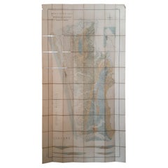
Large Topographical and Geological Map of the Teshio Oil Field,
1936
Located in Langweer, NL
Topographical and geological map of the Teshio oil field. Shows location of oil well, oil sand, natural gas, coal, Sulphur spring, anticlinal axis, prof...
Category
20th Century Maps
Materials
Linen, Paper
$1,151 Sale Price
20% Off
H 72.64 in W 38.39 in D 0.02 in
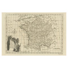
Original Copper Engraved Map of France
Located in Langweer, NL
Antique map titled 'New and Accurate Map of France from the latest improvements'. Original copper engraved map of France. Engraved by T. Bowen, published circa 1771.
Category
Antique Late 18th Century Maps
Materials
Paper
17th Century Topographical Map, French Champagne Region, Epernay, Iohan Peeters
Located in New York, NY
Fine topographical 17th century map by Iohan Peeters of the towns of Epernay and Lametz in the Champagne Region of North Eastern France.
Fabulous period engraving for a Wine Cellar,...
Category
Antique 17th Century Dutch Maps
Materials
Paper

$475
H 12.38 in W 15.5 in D 0 in
17th Century Topographical Map, Champagne-Ardenne, Marsal, Maubert Iohan Peeters
Located in New York, NY
Fine topographical 17th century map by Iohan Peeters of Marsal and Maubert Fontaine in the Champagne-Ardennes Region of North Eastern France.
Fabulous period engraving for a Wine Ce...
Category
Antique 17th Century Dutch Maps
Materials
Paper

$475
H 12.5 in W 15.5 in D 0 in
17th Century Toulouse, Savve, Sommieres Topographical Map by Iohan Peeters
Located in New York, NY
Fine topographical 17th century map of Toulouse, Savve and Sommieres by Iohan Peeters
Beautiful engraving of the capital of France's Occitanie Region, Toulouse, called La Ville Rose- the Pink City, for the terracotta bricks used in its many buildings, giving the city a distinct apricot-rose hue. An important cultural and educational center, the city's residents included Nobel Prize winners and world renown artists- Henri de Toulouse-Lautrec, Henri Martin, Jean-Auguste-Dominique Ingres, Antonin Mercie, Alexandre Falguiere and more recently Cyril Kongo...
Category
Antique 17th Century Dutch Maps
Materials
Paper

$475
H 12.38 in W 14.88 in D 0 in
17th Century Topographical Map of Cote D
azur, Avignon, Frejus by Iohan Peeters
Located in New York, NY
Fine topographical 17th century map by Iohan Peeters of the towns of Avignon and Frejus in the Cote d'Azur-Provence-Alpes Region of Southeastern France.
Beautifully suited decorativ...
Category
Antique 17th Century Dutch Maps
Materials
Paper

$475
H 12.5 in W 15 in D 0 in
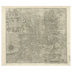
Antique Copper Engraved Map of Gloucestershire in England, 1637
Located in Langweer, NL
Antique map titled 'Glocestriae comitatus olim sedes Dobunorum'. Map of Gloucestershire, England. This map originates from Camden?s 'Britannia' ...
Category
Antique 17th Century Maps
Materials
Paper
Detailed Copper Engraved City Map of Enkuizen, the Netherlands, c.1620
By L. Guicciardini
Located in Langweer, NL
Antique map titled 'Die stadt Enchuijsen.' Detailed copper engraved city map of Enkuizen, the Netherlands, by Lodovico Guicciardini and published by Janssonius. Highly decorated with...
Category
Antique 17th Century Maps
Materials
Paper
$779
H 11.82 in W 13.59 in D 0 in
Map "Estuary- Mouth of the Thames"
Located in Alessandria, Piemonte
ST/426 - Antique French Map of the estuary of the Thames, map dated 1769 -
"Mape of the entrance of the Thames. Designed by filing of Navy cards fo...
Category
Antique Mid-18th Century French Other Prints
Materials
Paper

Still Thinking About These?
All Recently ViewedMore Ways To Browse
Copper Printing Plate
Antique Furniture Logos
Antique Leather Chaps
Antique Masonic Memorabilia
Antique Mercury Glass Tree Topper
Antique Metal Stencils
Antique Railway Memorabilia
Bird Christmas Ornament
Car Badge
Coronation Flag
Enterprise Coffee Grinder
General Patton
Gettysburg Furniture
Glass Mushroom Ornament
Hand Crank Sewing Machine
Keep Em Flying
Memorabilia Queen Elizabeth Ii
Nyc Memorabilia