Items Similar to 1625 Petrus Plancius / Cloppenburg Map of the Holy Land with Biblical Vignettes


Want more images or videos?
Request additional images or videos from the seller
1 of 8
1625 Petrus Plancius / Cloppenburg Map of the Holy Land with Biblical Vignettes
$1,131.82
£840.87
€950
CA$1,569.32
A$1,687.68
CHF 902.40
MX$20,352.89
NOK 11,411.51
SEK 10,397.36
DKK 7,240.58
About the Item
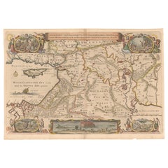
1625 Petrus Plancius / Johannes Cloppenburg Map of the Holy Land with Biblical Vignettes
This exquisite 1625 map by Petrus Plancius and Johannes Cloppenburg represents the Holy Land during the time of Christ, highlighting Canaan's political divisions. Originally designed to accompany a Dutch Bible, the map is adorned with 15 detailed vignettes depicting significant events from the life of Christ—from his genealogy to his resurrection appearances.
The map's decorative elements include a strapwork cartouche, a sailing ship, and a compass rose that orients north to the left. This is the second state of Plancius' series, with the addition of D.R.M. Mathes to the imprint, indicative of its later edition.
The map was part of the second series of Dutch Bible maps by Plancius, first published in 1604 by Johannes Cloppenburg. This series was notable for its use of art to enhance the understanding of biblical texts. Baptista van Deutecum, along with engravers Daniel van Bremden and Pieter Bast, contributed to the engraving, ensuring that the updated series retained artistic charm while adding greater geographical accuracy. The map is not only a cartographic representation of the Holy Land but also an artistic celebration of key moments from the life of Christ.
The detailed hand coloring adds to its visual appeal, making it an important artifact for understanding how early modern cartographers connected geography with biblical narratives.
Condition Report:
The map is in good condition with some age-related wear typical of its age.
Paper Quality: The paper is stable with no significant damage, though some minor toning is present, particularly along the edges, consistent with its age.
Coloring: The hand coloring remains vibrant and well preserved, enhancing the visual appeal of both the map and the surrounding vignettes.
Edges and Margins: The margins are generally intact with some minor creasing and slight toning. There are no significant tears or repairs visible along the edges.
Folds and Creases: Light folds are visible, likely due to its original binding or storage. These folds are not heavily worn and do not detract from the map's overall aesthetic.
Vignettes and Detail: The 15 biblical vignettes are clear and detailed, without significant fading or smudging.
Verso: The Dutch text on the verso is intact and readable, with minimal bleed-through that does not affect the front.
Summary: Overall, this map is in good condition for its age, with vibrant coloring and intact vignettes. Minor toning and light folds are present but do not impact the overall integrity or display quality of the piece.
- Dimensions:Height: 15.36 in (39 cm)Width: 20.48 in (52 cm)Depth: 0 in (0.02 mm)
- Materials and Techniques:Paper,Engraved
- Period:1620-1629
- Date of Manufacture:1625
- Condition:Good condition for its age, with vibrant coloring and intact vignettes. Minor toning and light folds are present but do not impact the overall integrity or display quality of the piece. Some repairs on the reverse.
- Seller Location:Langweer, NL
- Reference Number:Seller: BHZ98301stDibs: LU3054342590142
About the Seller
5.0
Recognized Seller
These prestigious sellers are industry leaders and represent the highest echelon for item quality and design.
Platinum Seller
Premium sellers with a 4.7+ rating and 24-hour response times
Established in 2009
1stDibs seller since 2017
2,826 sales on 1stDibs
Typical response time: 1 hour
- ShippingRetrieving quote...Shipping from: Langweer, Netherlands
- Return Policy
More From This Seller
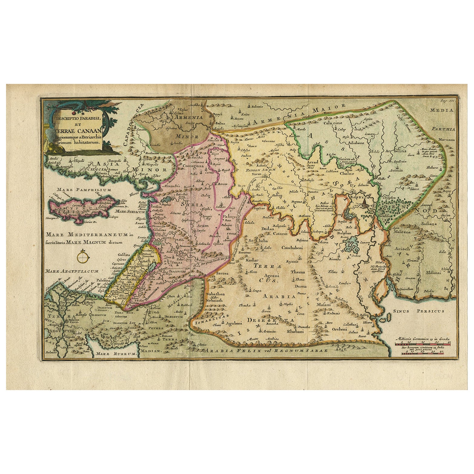
View AllAntique Map of the Holy Land and Paradise – Terrae Canaan Map, c.1720
Located in Langweer, NL
Antique Map of the Holy Land and Paradise by François Halma, c.1720
Beautiful early 18th-century hand-colored map of the Middle East extending from the Mediterranean Sea to the Pers...
Category
Antique Early 18th Century Dutch Maps
Materials
Paper

Antique Map of the Holy Land by Schut, 1710
Located in Langweer, NL
Antique map of the Holy Land titled 'Het Beloofde Landt Canaan.' Very detailed and decorative map of the Holy Land embellished with sailing ships and com...
Category
Antique 18th Century Maps
Materials
Paper

Antique Map of the Holy Land Described in the Old and New Testament, ca.1660
Located in Langweer, NL
Antique map titled 'Geographiae Sacrae ex Veteri et Novo Testamento Desumptae Tabula Prima quae Totius Orbis Partes Continet.'
Map of the lands described in the Old and New Testame...
Category
Antique 1660s Maps
Materials
Paper

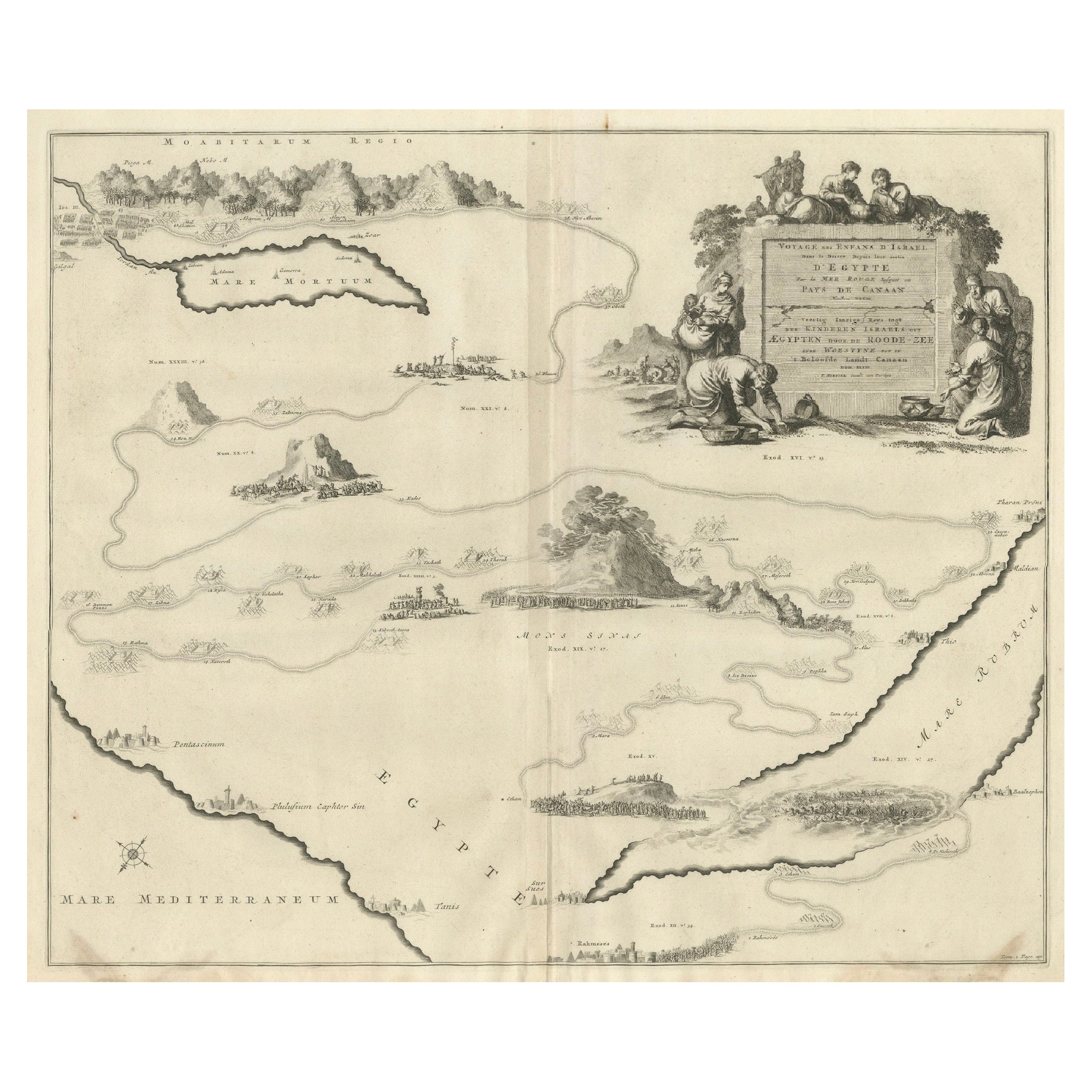
Decorative Map of the Holy Land, Wanderings of Moses by Pieter Mortier, ca. 1700
Located in Langweer, NL
Decorative Map of the Holy Land, Wanderings of Moses by Pieter Mortier, ca. 1700
Antique decorative map of the Holy Land depicting the Exodus of Moses and the Children of Israel fro...
Category
Antique Early 1700s Dutch Maps
Materials
Paper
Antique Map of the Holy Land by Keur, 1748
Located in Langweer, NL
Antique Map Holy Land titled 'De Gelegentheyd van t'Paradys ende t'Landt Canaan, Mitsgaders d'eerst bewoonde Landen der Patriarchen'. Includes five decorative vignettes, including No...
Category
Antique 18th Century Maps
Materials
Paper

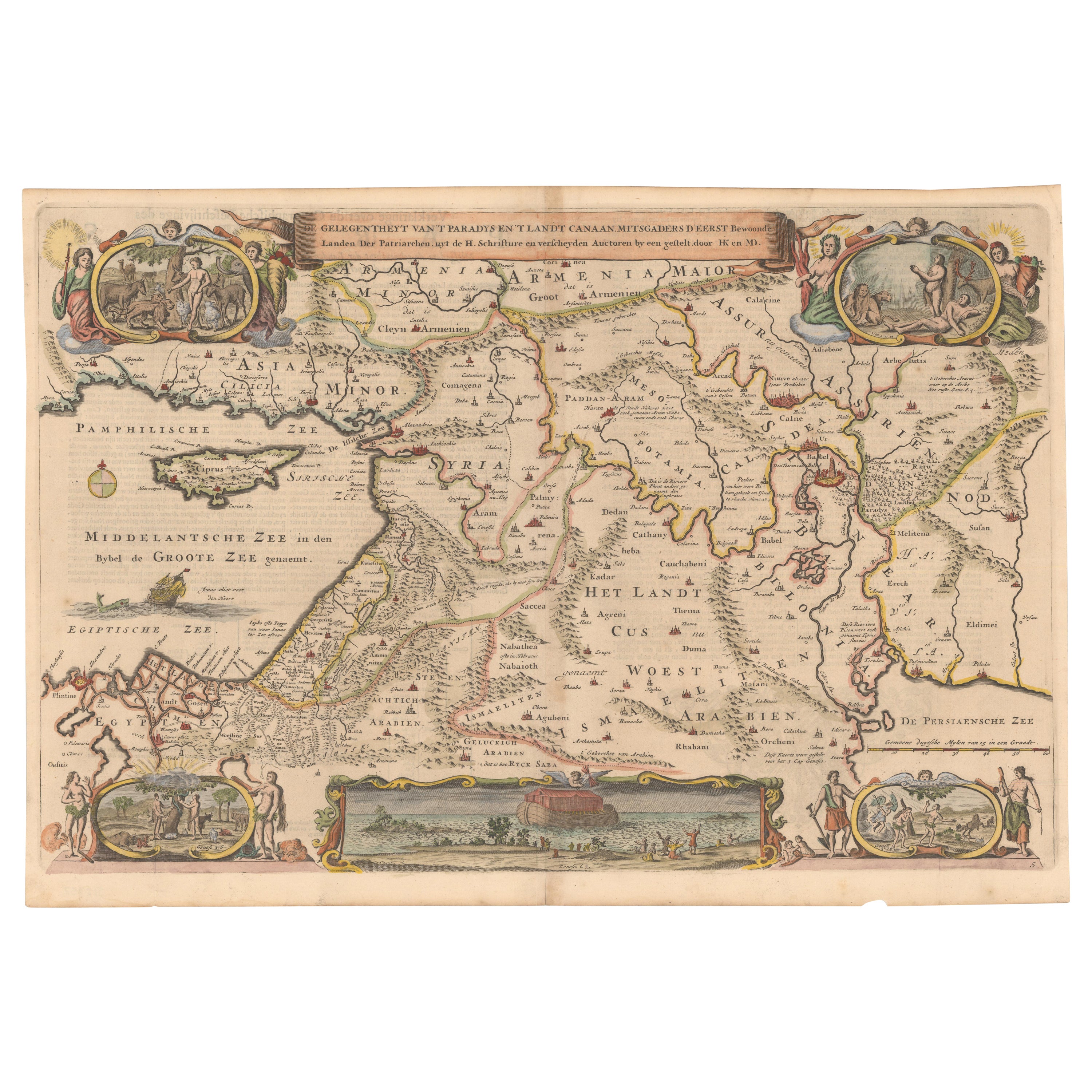
Circa 1686 Daniel Stoopendaal Map: Biblical Sites from Paradise to Canaan
Located in Langweer, NL
Circa 1686 Daniel Stoopendaal Map: Biblical Sites from Paradise to Canaan
This circa 1686 hand-colored map by Daniel Stoopendaal, titled "De Gelegentheyt van 't Paradys en 't Landt Canaan," beautifully illustrates the Middle East, extending from the Mediterranean to the Persian Gulf.
The map features numerous Biblical locations, such as the Garden of Eden, the wanderings of the Children of Israel, and the story of Jonas and the whale.
It is adorned with elaborate decorations, including a banner-style title cartouche and four corner vignettes depicting scenes from Genesis: Paradise, the creation of Adam and Eve, Eve offering the apple, and their expulsion from Eden.
The bottom center showcases a dramatic portrayal of Noah's Ark. Measuring 18.3 inches wide by 11.9 inches high, this first state map includes Dutch text on the reverse and is in good condition, with a crisp impression, light toning along the centerfold, and a small chip in the bottom margin.
Keywords:
- Daniel Stoopendaal map
- Biblical map
- Garden of Eden
- Land of Canaan
- Middle East historical map
- Noah's Ark map
- Adam and Eve
- 17th-century Bible...
Category
Antique 1680s Maps
Materials
Paper
$800 Sale Price
20% Off
You May Also Like
17th Century Dutch Map of the Holy Land at the Time of Jesus by Visscher
By Nicolaus Visscher
Located in Alamo, CA
This detailed Dutch map entitled "Het Beloofe de Landt Canaan door wandelt van onsen Salichmaecker Iesu Christo, nessens syne Apostelen" by Nicolaes Visscher (1610-1679), published i...
Category
1660s Prints and Multiples
Materials
Engraving

1630 Pierre Petit map "Description du Gouvernement de la Capelle" Ric0010
Located in Norton, MA
1630 Pierre Petit map entitled
"Description du Gouvernement de la Capelle,"
Ric0010
Pierre Petit was the son of a minor provincial official in Montluçon. The town, in the Auver...
Category
Antique 17th Century Dutch Maps
Materials
Paper

1640 Willem Blaeu Map Entitled "Contado di molise et principato vltra, " Ric.a003
By Willem Blaeu
Located in Norton, MA
1640 Willem Blaeu map entitled
"Contado di molise et principato vltra,"
Colored
Ric. a003
Measures: 38 x 49.6 cm and wide margins
DBLAEU.
Cou...
Category
Antique 17th Century Dutch Maps
Materials
Paper

Engraving Depicting 16th Century Map of Terra Sancta
Located in Buchanan, MI
Abraham Ortelius (Flemish, 1527-1598) Terra Sancta.
Engraving depicting 16th century map of Terra Sancta. Site 15" x 19.5.
Category
Antique 18th Century and Earlier Maps
Materials
Paper

1633 Map Entitled "Beauvaisis Comitatus Belova Cium, Ric.0002
Located in Norton, MA
1633 map entitled
"Beauvaisis Comitatus Belova Cium,"
Hand Colored
Ric.0002
Description: Cartographer : - Hondius, Henricus 1587-1638
Artists and Engravers:Jodocus Hondius, one of the most notable engravers of his time. He is known for his work in association with many of the cartographers and publishers prominent at the end of the sixteenth and the beginning of the seventeenth century. A native of Flanders, he grew up in Ghent, apprenticed as an instrument and globe maker and map engraver. In 1584, to escape the religious troubles sweeping the Low Countries at that time, he fled to London where he spent some years before finally settling in Amsterdam about 1593. In the London period he came into contact with the leading scientists and geographers of the day and engraved maps in The Mariner\\\\\\\\\\\\\\\'s Mirrour, the English edition of Waghenaer\\\\\\\\\\\\\\\'s Sea Atlas, as well as others with Pieter van den Keere, his brother-in-law. No doubt his temporary exile in London stood him in good stead, earning him an international reputation, for it could have been no accident that Speed chose Hondius to engrave the plates for the maps in The Theatre of the Empire of Great Britaine in the years between 1605 and 1610. In 1604 Hondius bought the plates of Mercator\\\\\\\\\\\\\\\'s Atlas which, in spite of its excellence, had not competed successfully with the continuing demand for the Ortelius Theatrum Orbis Terrarum. To meet this competition Hondius added about 40 maps to Mercator\\\\\\\\\\\\\\\'s original number and from 1606 published enlarged editions in many languages, still under Mercator\\\\\\\\\\\\\\\'s name but with his own name as publisher. These atlases have become known as the Mercator/Hondius series. The following year the maps were reengraved in miniature form and issued as a pocket Atlas Minor. After the death of Jodocus Hondius the Elder in 1612, work on the two atlases, folio and miniature, was carried on by his widow and sons, Jodocus II and Henricus, and eventually in conjunction with Jan Jansson in Amsterdam.
In all, from 1606 onwards, nearly 50 editions with increasing numbers of maps with texts in the main European languages were printed. Summaries of these issues are given under the entry for Gerard Mercator. Jodocus Hondius the Elder * 1588 Maps in The Mariner\\\\\\\\\\\\\\\'s Mirrour (Waghenaer/Ashley) * 1590 World Map...
Category
Antique 17th Century Dutch Maps
Materials
Paper

1643 Willem&Joan Blaeu Map NW Flanders "Flandriae Teutonicae Pars Prientalior
Located in Norton, MA
1643 Willem and Joan Blaeu map of northwest Flanders, entitled
"Flandriae Teutonicae Pars Prientalior,"
Ric0012
" Authentic" - Map of the northwest Fl...
Category
Antique 17th Century Dutch Maps
Materials
Paper

More Ways To Browse
18th Century Wood Side Tables
Antique Hand Carved Dining Room Sets
Mid Century Modern Pitcher
Vintage Italian Leather Dining Chair
Vintage Movie Posters
Blue Green Wool And Silk Rug
Brown Sheepskin Chair
Vintage Brass Bar Carts
Antique Botanical Prints
Green Persian Rug
17th Century Blue And White
50 X 50 Coffee Table
Antique Wood Panel Painted
Milo Baughman 1970
Spanish Baroque Furniture
Stone China
Couch Console
Vintage Burn