Items Similar to 1658 Large Map of the Holy Land by Jansson – Twelve Tribes of Israel in 6 Sheets


Want more images or videos?
Request additional images or videos from the seller
1 of 10
1658 Large Map of the Holy Land by Jansson – Twelve Tribes of Israel in 6 Sheets
$3,580.50per set
$4,475.63per set20% Off
£2,621.14per set
£3,276.43per set20% Off
€2,960per set
€3,700per set20% Off
CA$4,898.46per set
CA$6,123.07per set20% Off
A$5,178.93per set
A$6,473.67per set20% Off
CHF 2,783.02per set
CHF 3,478.77per set20% Off
MX$62,199.78per set
MX$77,749.72per set20% Off
NOK 34,848.30per set
NOK 43,560.37per set20% Off
SEK 31,888.76per set
SEK 39,860.95per set20% Off
DKK 22,546.77per set
DKK 28,183.46per set20% Off
About the Item
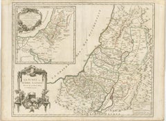
Holy Land Divided Among the Twelve Tribes – Six-Part Map by Jan Jansson and Georgius Hornius, circa 1658
This rare and impressive six-sheet engraved map of the Holy Land was published around 1658 by Jan Jansson and Georgius Hornius. The map is based on the influential work of Christian van Adrichom, whose 1590 design became the standard for visualizing the biblical divisions of the land of Israel among the Twelve Tribes. Oriented to the east, the map spans from the southern end of the Dead Sea and Edom up to the Golan Heights and modern-day Lebanon.
Each of the six sheets is richly detailed with engraved tribal boundaries, topographical features, and biblical references. The territories of the tribes are clearly outlined in contemporary hand color. The upper corners of the map feature inset illustrations showing Abraham’s journey and the wanderings of the Israelites through the desert. Additional scenes appear throughout the map, including the destruction of Sodom, Gomorrah, Admah, and Zeboiim in the Dead Sea, Jonah being swallowed by the whale, and Jesus confronting Satan on the mountain.
The engravings are executed on laid paper without watermarks. The two larger sheets each measure approximately 470 x 715 mm, while the four smaller sheets are about 470 x 550 mm. The joint sheets of this map will measure over 37 x 56,3 inch ( 94x1430 cm ). This map is not only a cartographic representation but also a richly symbolic and narrative depiction of sacred geography, intended to inform and inspire.
Condition:
Good overall but here are faint damp stains along the top edges of the sheets, minor nicks and small tears to some margins, and light creasing from handling. One sheet (upper left) has been carefully restored along a fold line. Some occasional spotting and surface dirt is present, consistent with age. All sheets are unframed.
Framing suggestion:
This six-part map would make a striking display when framed together in a custom arrangement. Archival materials and museum glass are recommended to preserve the engraved detail and hand coloring. It is an ideal centrepiece for a collection of 17th-century maps, Judaica, or biblical history.
- Dimensions:Height: 28.15 in (71.5 cm)Width: 18.51 in (47 cm)Depth: 0.01 in (0.2 mm)
- Sold As:Set of 6
- Materials and Techniques:Paper,Engraved
- Place of Origin:
- Period:Mid-17th Century
- Date of Manufacture:1658
- Condition:Good overall, but here are faint damp stains along the top edges of the sheets, minor nicks and small tears to some margins, and light creasing from handling. Some occasional spotting and surface dirt is present, consistent with age. Unframed sheets.
- Seller Location:Langweer, NL
- Reference Number:Seller: BG-13932-1, -2, -3, -4, -5, -61stDibs: LU3054345603992
About the Seller
5.0
Recognized Seller
These prestigious sellers are industry leaders and represent the highest echelon for item quality and design.
Platinum Seller
Premium sellers with a 4.7+ rating and 24-hour response times
Established in 2009
1stDibs seller since 2017
2,854 sales on 1stDibs
Typical response time: 1 hour
- ShippingRetrieving quote...Shipping from: Langweer, Netherlands
- Return Policy
More From This Seller
View AllAntique Holy Land Map, Twelve Tribes of Israel – Covens
Mortier, c.1700
Located in Langweer, NL
Antique Holy Land Map, Twelve Tribes of Israel – Covens
Mortier, c.1700
Description:
This finely engraved early 18th-century map depicts the Holy Land divided according to the...
Category
Antique Early 18th Century French Maps
Materials
Paper

1718 Holy Land Map - Twelve Tribes, Six Provinces, Hand-Colored, Antique Map
Located in Langweer, NL
Title: Terra Sancta in XII olim Tribus nunc VI Provincias Dispertita
Cartographer: Christoph Weigel the Elder (1654–1725)
Publisher: Johann Ernst Adelbulner
Publication Locatio...
Category
Antique 1710s German Maps
Materials
Paper

Holy Land Map of the Twelve Tribes of Israel, After Sanson, Paris c.1798
Located in Langweer, NL
Holy Land, Twelve Tribes of Israel – After Nicolas Sanson, De Vaugondy / Delamarche, c.1798
Description:
Holy Land. De Vaugondy (G. R.), Carte de la Terre des Hébreux ou Israélites,...
Category
Antique Late 18th Century French Maps
Materials
Paper

Judaea or Terra Sancta, Twelve Tribes of Israel – Sanson Map, c.1680
Located in Langweer, NL
Judaea or Terra Sancta, Twelve Tribes of Israel – Sanson Map, c.1680
This antique map depicts Judaea or the Holy Land divided among the Twelve Tribes of Israel, based on biblical ge...
Category
Antique Late 17th Century Dutch Maps
Materials
Paper
Antique French Map of the Holy Land, Twelve Tribes of Israel, c.1750
Located in Langweer, NL
Antique Holy Land Map, Twelve Tribes of Israel – Robert de Vaugondy, c.1750
Description
This finely engraved and hand-colored map depicts Judea, or the Holy Land, divided according ...
Category
Antique Mid-18th Century French Maps
Materials
Paper
Hand-Colored Map of the Holy Land Divided Among the Twelve Tribes, c.1720
Located in Langweer, NL
Hand-Colored Map of the Holy Land Divided Among the Twelve Tribes, c.1720
This striking antique map, titled "Iudaea seu Palaestina ob Sacratissima Redemtoris Vestigia Hodie Dicta Te...
Category
Antique Early 18th Century German Maps
Materials
Paper

You May Also Like
1635 Willem Blaeu Map of Northern France"Comitatvs Bellovacvm" Ric.a08
Located in Norton, MA
1635 Willem Blaeu map of northern France, entitled.
"Comitatvs Bellovacvm Vernacule Beavvais,"
Colored
Ric.a008
“COMITATVS BELLOVACVM…” Amsterdam: W...
Category
Antique 17th Century Unknown Maps
Materials
Paper

1640 Joan Bleau Map Entitled"Diocecese de rheims et le pais de rethel, " Eic.a011
Located in Norton, MA
1640 Joan Bleau map entitled
"Diocecese de rheims et le pais de rethel,"
Ric.a011
OAN BLAEU
Diocecese de Rheims, et le pais de Rethel.
Handcolored engraving, c.1640.
...
Category
Antique 17th Century Dutch Maps
Materials
Paper

1657 Janssonius Map of Vermandois and Cappelle, Ric. A-004
Located in Norton, MA
1657 Janssonius map of
Vermandois and Cappelle
Ric.a004
Description: Antique map of France titled 'Descriptio Veromanduorum - Gouvernement de la Cappelle'. Two detailed maps o...
Category
Antique 17th Century Unknown Maps
Materials
Paper

17th Century Hand Colored Map of the Liege Region in Belgium by Visscher
By Nicolaes Visscher II
Located in Alamo, CA
An original 17th century map entitled "Leodiensis Episcopatus in omnes Subjacentes Provincias distincté divisusVisscher, Leodiensis Episcopatus" by Nicolaes Visscher II, published in Amsterdam in 1688. The map is centered on Liege, Belgium, includes the area between Antwerp, Turnhout, Roermond, Cologne, Trier and Dinant.
This attractive map is presented in a cream-colored mat measuring 30" wide x 27.5" high. There is a central fold, as issued. There is minimal spotting in the upper margin and a tiny spot in the right lower margin, which are under the mat. The map is otherwise in excellent condition.
The Visscher family were one of the great cartographic families of the 17th century. Begun by Claes Jansz Visscher...
Category
Antique Late 17th Century Dutch Maps
Materials
Paper

1627 Hondius Map "La Principaute d
Orange et Comtat de Ve", Ric.0003
Located in Norton, MA
1627 Hondius map entitled
"La Principaute d'Orange et Comtat de Venaissin,"
Original Hand-Colored
Description: From Johannes Janssonius's Atlantis Maioris Appendix of 1630.
...
Category
Antique 17th Century Unknown Maps
Materials
Paper

Southern Greece: A Large 17th C. Hand-colored Map by Sanson and Jaillot
By Nicolas Sanson
Located in Alamo, CA
This large original hand-colored copperplate engraved map of southern Greece and the Pelopponese Peninsula entitled "La Moree Et Les Isles De Zante, Cefalonie, Ste. Marie, Cerigo & C...
Category
Antique 1690s French Maps
Materials
Paper

More Ways To Browse
Antique Swallow
Israel Mid Century Modern Furniture
Antique Satan
Antique Victorian Dining Tables
Italian Plastic Chairs
Black Crystal Glasses
French Mid Century Modern Rug
China Silk Rug
Chrome Glass Coffee Tables
Antique Italian Chairs
Antique Walnut Bar
Beni Ourain Rugs
French Iron And Glass Table
Glass Top Wood Base Coffee Tables
T Chair
Antique Silver Basket
Antique Walkers
Ebony Wood Furniture