Want more images or videos?
Request additional images or videos from the seller
1 of 7
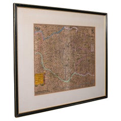
1675 Map of the Kingdom of the Black People (Nigritarum Regnum) by Janssonius
Price:$706.59
$882.81List Price
About the Item
- Dimensions:Height: 20.08 in (51 cm)Width: 23.43 in (59.5 cm)Depth: 0 in (0.02 mm)
- Materials and Techniques:Paper,Engraved
- Period:1670-1679
- Date of Manufacture:1675
- Condition:The map is in good condition with minor age-toning. Edges may have light wear, and there are occasional small stains. Colors are well-preserved, enhancing decorative elements. Original centerfold intact with minimal handling marks or creasing.
- Seller Location:Langweer, NL
- Reference Number:Seller: BG-13647-11stDibs: LU3054342043892
About the Seller
5.0
Recognized Seller
These prestigious sellers are industry leaders and represent the highest echelon for item quality and design.
Platinum Seller
Premium sellers with a 4.7+ rating and 24-hour response times
Established in 2009
1stDibs seller since 2017
2,830 sales on 1stDibs
Typical response time: 1 hour
Authenticity Guarantee
In the unlikely event there’s an issue with an item’s authenticity, contact us within 1 year for a full refund. DetailsMoney-Back Guarantee
If your item is not as described, is damaged in transit, or does not arrive, contact us within 7 days for a full refund. Details24-Hour Cancellation
You have a 24-hour grace period in which to reconsider your purchase, with no questions asked.Vetted Professional Sellers
Our world-class sellers must adhere to strict standards for service and quality, maintaining the integrity of our listings.Price-Match Guarantee
If you find that a seller listed the same item for a lower price elsewhere, we’ll match it.Trusted Global Delivery
Our best-in-class carrier network provides specialized shipping options worldwide, including custom delivery.You May Also Like
Map of the Kingdom of Sardinia and Part of the Kingdom of Genoa, Rome
By Giovanni Maria Cassini
Located in Hamilton, Ontario
18th century map by Italian engraver Giovanni Maria Cassini (Italy 1745-1824). Map of Part of the Kingdom of Sardinia and Part of the Kingdom of Genoa: Rome. This is a hand colored a...
Category
Antique 18th Century Italian Maps
Materials
Paper

$795 Sale Price
36% Off
H 20.75 in W 25.25 in D 0.1 in
Large Original Vintage Map of the United Kingdom, circa 1920
Located in St Annes, Lancashire
Great map of The United Kingdom
Unframed
Original color
By John Bartholomew and Co. Edinburgh Geographical Institute
Published, circa 1920
Free shipping.
Category
Vintage 1920s British Maps
Materials
Paper

$50
Free Shipping
H 23 in W 18 in D 0.07 in
1657 Janssonius Map of Vermandois and Cappelle, Ric. A-004
Located in Norton, MA
1657 Janssonius map of
Vermandois and Cappelle
Ric.a004
Description: Antique map of France titled 'Descriptio Veromanduorum - Gouvernement de la Cappelle'. Two detailed maps o...
Category
Antique 17th Century Unknown Maps
Materials
Paper

Antique Map of Bohemia, Dutch, Framed Cartography, Johannes Janssonius, C.1630
Located in Hele, Devon, GB
This is an antique map of Bohemia. A Dutch, framed atlas engraving of modern day Germany, Austria and the Czech Republic by Johannes Janssonius, dating to the 17th century and later,...
Category
Antique 17th Century Dutch Baroque Maps
Materials
Glass, Paper
$1,812
H 24.22 in W 27.56 in D 1.19 in
Antique County Map of Cheshire, Dutch, Framed, Cartography, Janssonius, C.1660
Located in Hele, Devon, GB
This is an antique county map of Cheshire. A Dutch, framed atlas engraving by Johannes Janssonius, dating to the 17th century and later.
A treat for the collector or county native,...
Category
Antique Mid-17th Century Dutch Charles II Maps
Materials
Glass, Wood, Paper

$2,271
H 22.05 in W 25.99 in D 0.99 in
Antique County Map, Buckinghamshire, Bedfordshire, Dutch, Framed, Janssonius
Located in Hele, Devon, GB
This is an antique county map of Buckinghamshire and Bedfordshire. A Dutch, framed atlas engraving by Johannes Janssonius, dating to the 17th century and later.
A treat for the col...
Category
Antique Mid-17th Century Dutch Maps
Materials
Paper

$1,655
H 24.02 in W 27.76 in D 0.79 in
17th Century Hand-Colored Map of a Region in West Germany by Janssonius
By Johannes Janssonius
Located in Alamo, CA
This attractive highly detailed 17th century original hand-colored map is entitled "Archiepiscopatus Maghdeburgensis et Anhaltinus Ducatus cum terris adjacentibus". It was published ...
Category
Antique Mid-17th Century Dutch Maps
Materials
Paper

$1,275
H 27.5 in W 30 in D 0.13 in
Prussia, Poland, N. Germany, Etc: A Hand-colored 17th Century Map by Janssonius
By Johannes Janssonius
Located in Alamo, CA
This is an attractive hand-colored copperplate engraved 17th century map of Prussia entitled "Prussia Accurate Descripta a Gasparo Henneberg Erlichensi", published in Amsterdam by Joannes Janssonius in 1664. This very detailed map from the golden age of Dutch cartography includes present-day Poland, Latvia, Lithuania, Estonia and portions of Germany. This highly detailed map is embellished by three ornate pink, red, mint green and gold...
Category
Antique Mid-17th Century Dutch Maps
Materials
Paper

$1,275
H 21.25 in W 24.63 in D 0.07 in
The Kingdom of Naples and Southern Italy: A Hand-Colored 18th Century Homann Map
By Johann Baptist Homann
Located in Alamo, CA
"Novissima & exactissimus Totius Regni Neapolis Tabula Presentis Belli Satui Accommo Data" is a hand colored map of southern Italy and the ancient Kingdom of Naples created by Johann...
Category
Antique Early 18th Century German Maps
Materials
Paper

$1,175
H 20 in W 23.88 in D 0.07 in
Map of the Republic of Genoa
Located in New York, NY
Framed antique hand-coloured map of the Republic of Genoa including the duchies of Mantua, Modena, and Parma.
Europe, late 18th century.
Dimension: 25...
Category
Antique Late 18th Century European Maps

More From This Seller
View AllAntique Map of the Maine Region by Janssonius, 1657
By Johannes Janssonius
Located in Langweer, NL
Antique map of France titled 'Diocese du Mans vulgo le Mains'. Decorative map of the region of Maine, France. This map originates from 'Atlas Novus, Sive Theatrum Orbis Orbis Terraru...
Category
Antique 17th Century Maps
Materials
Paper

Antique Map of the Region of Rethelois by Janssonius, 1657
By Johannes Janssonius
Located in Langweer, NL
Antique map of France titled 'Dioecese de Rheims et le Païs de Rethel'. Detailed map, centered on the River Ayne and the River Velle and sowing Reims, Chalons, Sedan, Charleville, as...
Category
Antique Mid-17th Century Maps
Materials
Paper

Antique Map of the Region of Lyonnais by Janssonius,
1657
By Johannes Janssonius
Located in Langweer, NL
Antique map 'Lionnois, forest, beauviolois et masconnois'. Decorative map of the Lyonnais region, France. The Lyonnais is a historical province of France which owes its name to the c...
Category
Antique Mid-17th Century Maps
Materials
Paper

Antique Map of the Region of Picardy by Janssonius, 1657
By Johannes Janssonius
Located in Langweer, NL
Antique map of France titled 'Picardia vera et inferior'. Detailed map of the Picardy region of France. This map originates from 'Atlas Novus, Sive Theatrum Orbis Orbis Terrarum: In ...
Category
Antique Mid-17th Century Maps
Materials
Paper

Antique Map of the Region of Charolais by Janssonius, 1657
By Johannes Janssonius
Located in Langweer, NL
Antique map 'Les environs de L'Estang de Longpendu, comprenant une grande partie du Comté de Charolois'. Decorative map of the Charolais region. This map originates from 'Atlas Novus...
Category
Antique Mid-17th Century Maps
Materials
Paper
Antique Map of the Region of Aiguillon by Janssonius, 1657
By Johannes Janssonius
Located in Langweer, NL
Antique map 'Le Duche d'Aiguillon'. Decorative map of the Aiguillon region, France. Located at the confluence of the Lot and Garonne rivers. The map is based on the cartography of Pi...
Category
Antique Mid-17th Century Maps
Materials
Paper
Still Thinking About These?
All Recently ViewedMore Ways To Browse
17th Century Keys
Black Scandinavian Modern Dining Chairs
Gold Modern Coffee Table
Round Glass Coffee Tables
18th Century Wood Side Tables
Antique Hand Carved Dining Room Sets
Mid Century Modern Pitcher
Vintage Italian Leather Dining Chair
Vintage Movie Posters
Blue Green Wool And Silk Rug
Brown Sheepskin Chair
Vintage Brass Bar Carts
Antique Botanical Prints
Green Persian Rug
17th Century Blue And White
50 X 50 Coffee Table
Antique Wood Panel Painted
Milo Baughman 1970