Items Similar to 1692 Engraved Map: Detailed Mogul Empire, India to Afghanistan, Hand-Colored


Want more images or videos?
Request additional images or videos from the seller
1 of 8
1692 Engraved Map: Detailed Mogul Empire, India to Afghanistan, Hand-Colored
$469.55
$586.9420% Off
£351.12
£438.9020% Off
€392
€49020% Off
CA$646.93
CA$808.6620% Off
A$705.56
A$881.9520% Off
CHF 373.76
CHF 467.2020% Off
MX$8,458.70
MX$10,573.3720% Off
NOK 4,760.04
NOK 5,950.0520% Off
SEK 4,352.70
SEK 5,440.8820% Off
DKK 2,987.20
DKK 3,73420% Off
About the Item
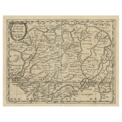
1692 Map of the Mogul Empire by Jacques Peeters
This finely engraved map, published in 1692 by Jacques Peeters, showcases the Mogul Empire region, covering areas from northern India to parts of Afghanistan, Tibet, Nepal, and Bhutan.
The map is rich with details, illustrating mountains, rivers, and cities, providing a comprehensive view of the geography and settlements of the time. It features a decorative title cartouche that includes a tiny coat of arms.
The map measures 6.1 inches in width by 5.4 inches in height. It is in good condition, with a crisp impression, minor marginal soiling, a hint of toning, and a small separation at the bottom centerfold.
Keywords for Online Listing:
- Mogul Empire
- Northern India
- Afghanistan
- Tibet
- Nepal
- Bhutan
- Historical map
- 17th century
- Jacques Peeters
- L'Atlas en Abrege
- Decorative cartouche
- Mountains and rivers
- Cities of the Mogul Empire
- Dimensions:Height: 5.4 in (13.72 cm)Width: 6.1 in (15.5 cm)Depth: 0.002 in (0.06 mm)
- Materials and Techniques:
- Period:1690-1699
- Date of Manufacture:1692
- Condition:It is in good condition, with a crisp impression, minor marginal soiling, a hint of toning, and a small separation at the bottom centerfold.
- Seller Location:Langweer, NL
- Reference Number:Seller: BG-138581stDibs: LU3054341276712
About the Seller
5.0
Recognized Seller
These prestigious sellers are industry leaders and represent the highest echelon for item quality and design.
Platinum Seller
Premium sellers with a 4.7+ rating and 24-hour response times
Established in 2009
1stDibs seller since 2017
2,788 sales on 1stDibs
Typical response time: <1 hour
- ShippingRetrieving quote...Shipping from: Langweer, Netherlands
- Return Policy
More From This Seller
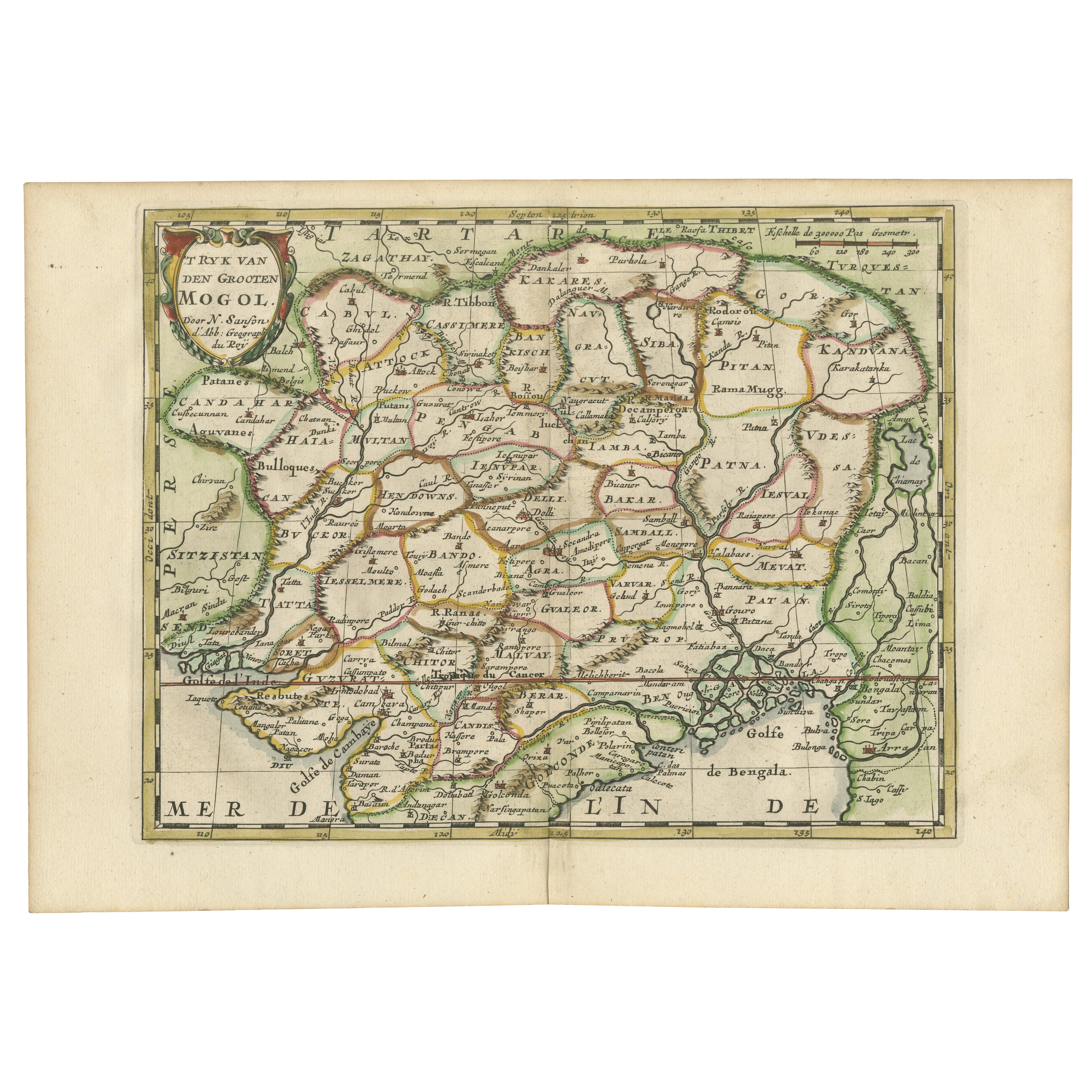
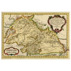
View AllCartographic Elegance of the Mughal Dominion in a Hand-Colored Antique Map, 1705
Located in Langweer, NL
This original antique map titled “'T Ryk van den Grooten Mogol” by Nicolas Sanson from 1705 is an interesting historical artifact. It depicts the extent of the Mughal Empire in North...
Category
Antique Early 1700s Maps
Materials
Paper
$632 Sale Price
20% Off
Free Shipping
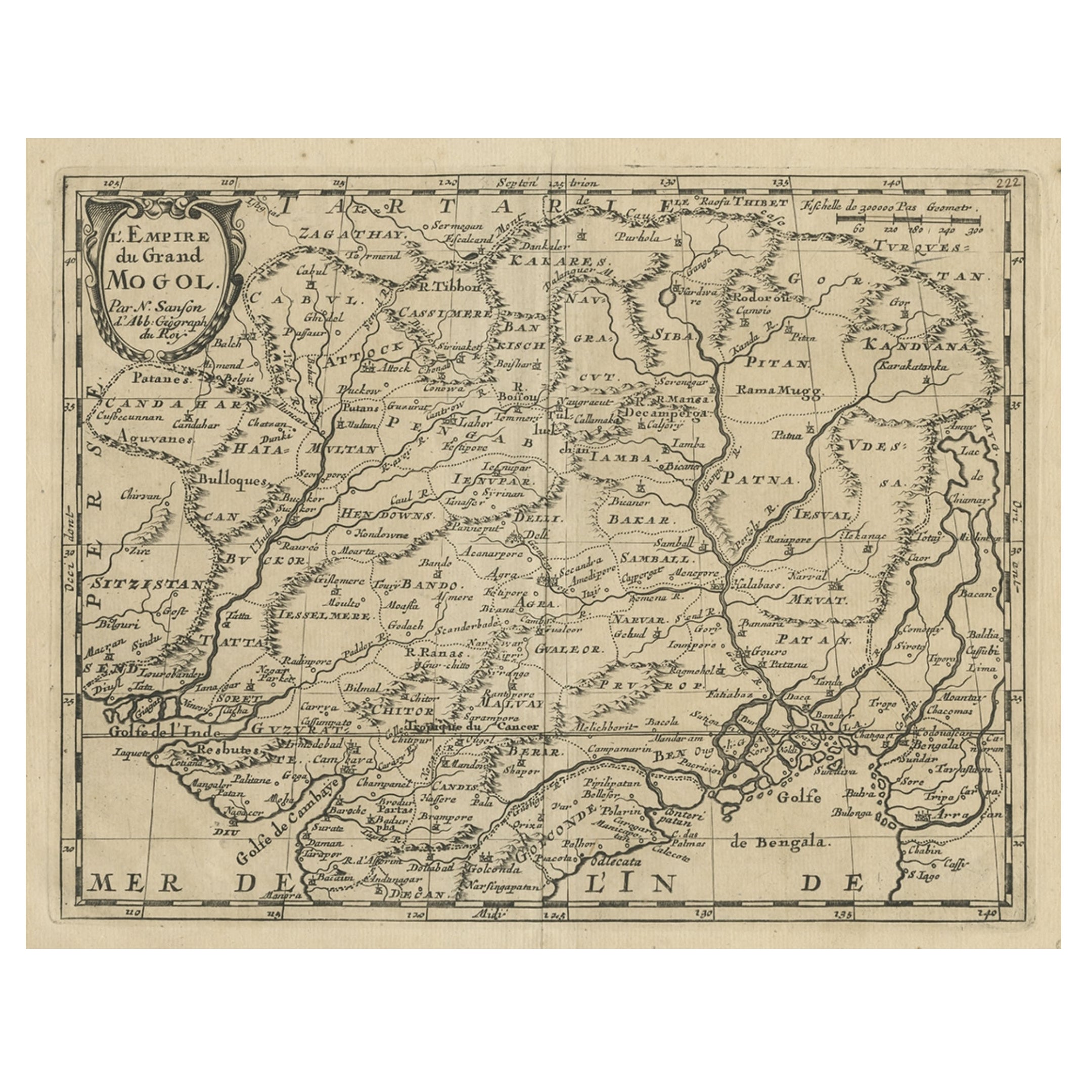
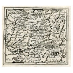
Old Map of the Mughal Empire, Persia in the West to Lake Chimay etc., ca.1685
Located in Langweer, NL
Antique map titled 'L'Empire du Grand Mogol'. Old map of India and Central Asia.
The map extends from Persia in the West to Lake Chimay and the Bay of Bengal...
Category
Antique 1680s Maps
Materials
Paper
$306 Sale Price
20% Off
Antique Map of the Mughal Empire by Van der Aa, C.1725
By Pieter Van Der Aa
Located in Langweer, NL
Antique map titled 'Royaume de Grand Mogol (..).' This map shows the extend of the Mughal Empire, which includes northern India, from Golconda to Afghanistan and eastwards to Bengal....
Category
Antique 18th Century Maps
Materials
Paper

Antique Map of Persia by A. Zatta, circa 1785
Located in Langweer, NL
Antique map titled 'L'Impero della Persia diviso ne suoi Stati'. The Empire of Persia divided into its states. Originates from 'Atlante Novissimo, illustrato ed accresciuto sulle oss...
Category
Antique Late 18th Century Italian Maps
Materials
Paper

Nicely Hand-Colored Antique Map of Part of India, the Ganges
Hindustan, 1755
Located in Langweer, NL
Antique map titled 'Carte de l'Inde en deca du Gange comprenant l' Indoustan (..)'
A map of part of India, the Ganges and Hindustan. From: Antoine Francois Prevost d'Exiles' (or ...
Category
Antique 1750s Maps
Materials
Paper
$613 Sale Price
20% Off
Map of Northern India and Pakistan
Mogol
, Showing Kabul, Delhi Etc., 1758
Located in Langweer, NL
Antique map titled 'Mogol'.
Map of Northern India and Pakistan ('Mogol'), showing Kabul, Delhi and surroundings. This map originates from 'Kort begrip der Oude en Nieuwe Staatkun...
Category
Antique 1750s Maps
Materials
Paper
$354 Sale Price
20% Off
You May Also Like
1640 Willem Blaeu Map Entitled "Contado di molise et principato vltra, " Ric.a003
By Willem Blaeu
Located in Norton, MA
1640 Willem Blaeu map entitled
"Contado di molise et principato vltra,"
Colored
Ric. a003
Measures: 38 x 49.6 cm and wide margins
DBLAEU.
Cou...
Category
Antique 17th Century Dutch Maps
Materials
Paper

1590 Mercator Map Entitled "France Picardie Champaigne, Ric.0001
Located in Norton, MA
Description: Published in Amsterdam by Mercator/Hondius ca. 1590.
Ric.0001
Artists and Engravers: Map : 'France Picardie Champaigne cum regionibus adiacentibus'. (Map of the french provinces of Picardie and Champagne.) Copper engraved map of the french provinces of Picardie and Champagne, showing the cities of Caen, Paris, Melun, Auxerre, Verdun, etc. Copperplate engraving on verge type hand laid paper with watermark. Description: Published in Amsterdam by Mercator/Hondius ca. 1600.Artists and Engravers: Mercator was born in Rupelmonde in Flanders and studied in Louvain under Gemma Frisius, Dutch writer, astronomer and mathematician. The excellence of his work brought him the patronage of Charles V, but in spite of his favor with the Emperor he was caught up in the persecution of Lutheran protestants and charged with heresy, fortunately without serious consequences. No doubt the fear of further persecution influenced his move in 1552 to Duisburg, where he continued the production of maps, globes and instruments. Mercator's sons and grandsons, were all cartographers and made their contributions in various ways to his atlas. Rumold, in particular, was responsible for the complete edition in 1595. The map plates...
Category
Antique 16th Century Dutch Maps
Materials
Paper

Antique French Map of Asia Including China Indoneseia India, 1783
Located in Amsterdam, Noord Holland
Very nice map of Asia. 1783 Dedie au Roy.
Additional information:
Country of Manufacturing: Europe
Period: 18th century Qing (1661 - 1912)
Condition: Overall Condition B (Good Used)...
Category
Antique 18th Century European Maps
Materials
Paper

$486 Sale Price
40% Off
1654 Joan Blaeu Map the Sutherland, Scotland, Entitled "Southerlandia, "Ric0007
Located in Norton, MA
1654 Joan Blaeu map of the
Sutherland, Scotland, entitled
"Southerlandia,"
Hand Colored
Ric0007
Description:
Lovely map centered on Sedan and D...
Category
Antique 17th Century Dutch Maps
Materials
Paper

1571-1638 Willem Blaeu map entitled, "Ilcadorino, " Hand Colored Ric0009
Located in Norton, MA
Willem Blaeu map entitled,
"Ilcadorino,".
Hand colored.
Description: large, unusual, and nice antique copper engraved map of Ilcadorino, by Willem BL...
Category
Antique 16th Century Dutch Maps
Materials
Paper

1627 Hendrik Hondius Map Entitled "Vltoniae Orientalis Pars, " Ric.a009
Located in Norton, MA
1627 Hendrik Hondius map entitled
"Vltoniae orientalis pars,"
Ric.a009
Title:
Vltoniae orientalis : pars
Title (alt.) :
Ultoniae orientalis pars
Creator:
Mercator, Gerh...
Category
Antique 17th Century Dutch Maps
Materials
Paper

More Ways To Browse
Goblets
Mid Century Modern Yellow Chair
Paulin Pierre
Used Pianos Pianos
18th Century Engravings
Antique Carved Wood Chair
Black Scandinavian Modern Dining Chairs
Dutch Mid Century Modern Table
Gold Modern Coffee Table
Iconic Modern Furniture
Japanese Metal
Midcentury Modern Gray Glass Vase
Round Glass Coffee Tables
Vintage Cave
18th Century Wood Side Tables
Antique Hand Carved Dining Room Sets
Mid Century Modern Pitcher
Vintage Italian Leather Dining Chair