Items Similar to 17th-Century Coronelli Map of Europe, Engraved Detail, Venice 1692


Want more images or videos?
Request additional images or videos from the seller
1 of 9
17th-Century Coronelli Map of Europe, Engraved Detail, Venice 1692
$2,770.58
$3,463.2320% Off
£2,070.22
£2,587.7820% Off
€2,320
€2,90020% Off
CA$3,821.60
CA$4,77720% Off
A$4,186.44
A$5,233.0620% Off
CHF 2,203.58
CHF 2,754.4820% Off
MX$49,966.31
MX$62,457.8920% Off
NOK 28,090.09
NOK 35,112.6120% Off
SEK 25,678.57
SEK 32,098.2220% Off
DKK 17,676.58
DKK 22,095.7320% Off
About the Item
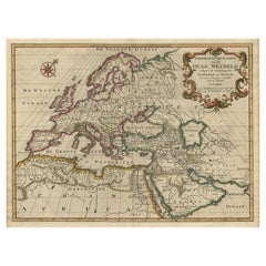
Large 17th-Century Coronelli Map of Europe with Mythical Islands and Rich Detail
This exceptional two-sheet map of Europe by Vincenzo Maria Coronelli, published in Venice in 1692, is a magnificent example of late 17th-century cartography. Covering a vast region from Greenland and Iceland to Russia, Ukraine, and the Mediterranean, the map reflects Coronelli’s dedication to detail and the artistic elegance of the period.
One of the standout features of this map is its depiction of Iceland, prominently featuring volcanoes such as Mount Helca, capturing the scientific curiosity and geological knowledge of the era. The inclusion of the mythical island of Frisland, a cartographic curiosity stemming from medieval legends, highlights the fusion of known and speculative geography that characterized this age of exploration.
Coronelli’s treatment of Greenland and its proximity to Iceland is an interesting example of the geographic uncertainties of the time. The detailed portrayal of remote Arctic regions, such as Nuova Zembla, showcases his commitment to depicting even the least explored corners of the world. The map’s artistic flourishes include dramatic maritime folklore, such as a vignette of a sea monster being harpooned, which offers a fascinating glimpse into contemporary beliefs.
Decorative cartouches and a scale of miles add to the map’s visual appeal, complementing its scientific and historical significance. The engraving technique demonstrates Coronelli’s expertise, blending precise cartographic accuracy with aesthetic craftsmanship.
This map is a testament to Coronelli’s legacy as a pioneering cartographer and cosmographer. A renowned figure in European mapmaking, Coronelli’s works remain highly sought after for their historical, artistic, and scholarly value.
Condition:
Very good with vibrant colors and clear details. Slight age toning and minimal wear typical of its age, adding to its authenticity and character.
Tips for Matting and Framing:
Consider using archival-quality materials and a museum-grade UV-protected glass frame to preserve the vibrant colors and delicate details of this historical piece. A wide, neutral-toned mat will highlight the ornate cartouches and intricate engraving, making this map a striking centerpiece for display.
- Dimensions:Height: 26.97 in (68.5 cm)Width: 36.62 in (93 cm)Depth: 0.01 in (0.2 mm)
- Materials and Techniques:Paper,Engraved
- Place of Origin:
- Period:1690-1699
- Date of Manufacture:1692
- Condition:Very good with vibrant colors and clear details. Slight age toning and minimal wear typical of its age, adding to its authenticity and character.
- Seller Location:Langweer, NL
- Reference Number:Seller: BGCP-0171stDibs: LU3054343557612
About the Seller
5.0
Recognized Seller
These prestigious sellers are industry leaders and represent the highest echelon for item quality and design.
Platinum Seller
Premium sellers with a 4.7+ rating and 24-hour response times
Established in 2009
1stDibs seller since 2017
2,809 sales on 1stDibs
Typical response time: 1 hour
- ShippingRetrieving quote...Shipping from: Langweer, Netherlands
- Return Policy
More From This Seller
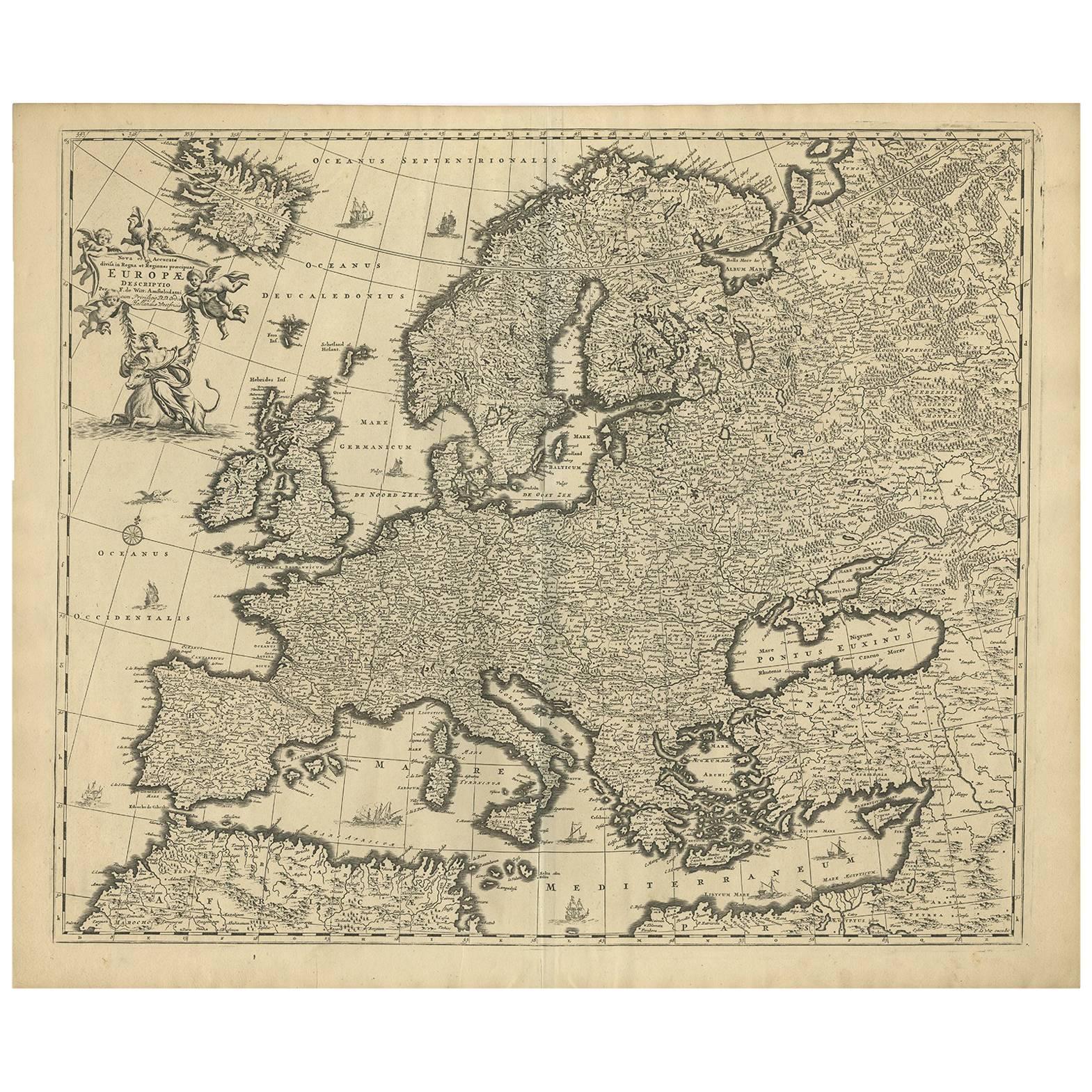
View AllGrand Map of Europe by Frederick de Wit, Circa 1690: A Baroque Era Masterpiece.
Located in Langweer, NL
This is an attractive historical map of Europe created by Frederick de Wit, published around 1690. Here's a detailed description of the map and additional context about its creation:...
Category
Antique Late 17th Century Dutch Maps
Materials
Paper
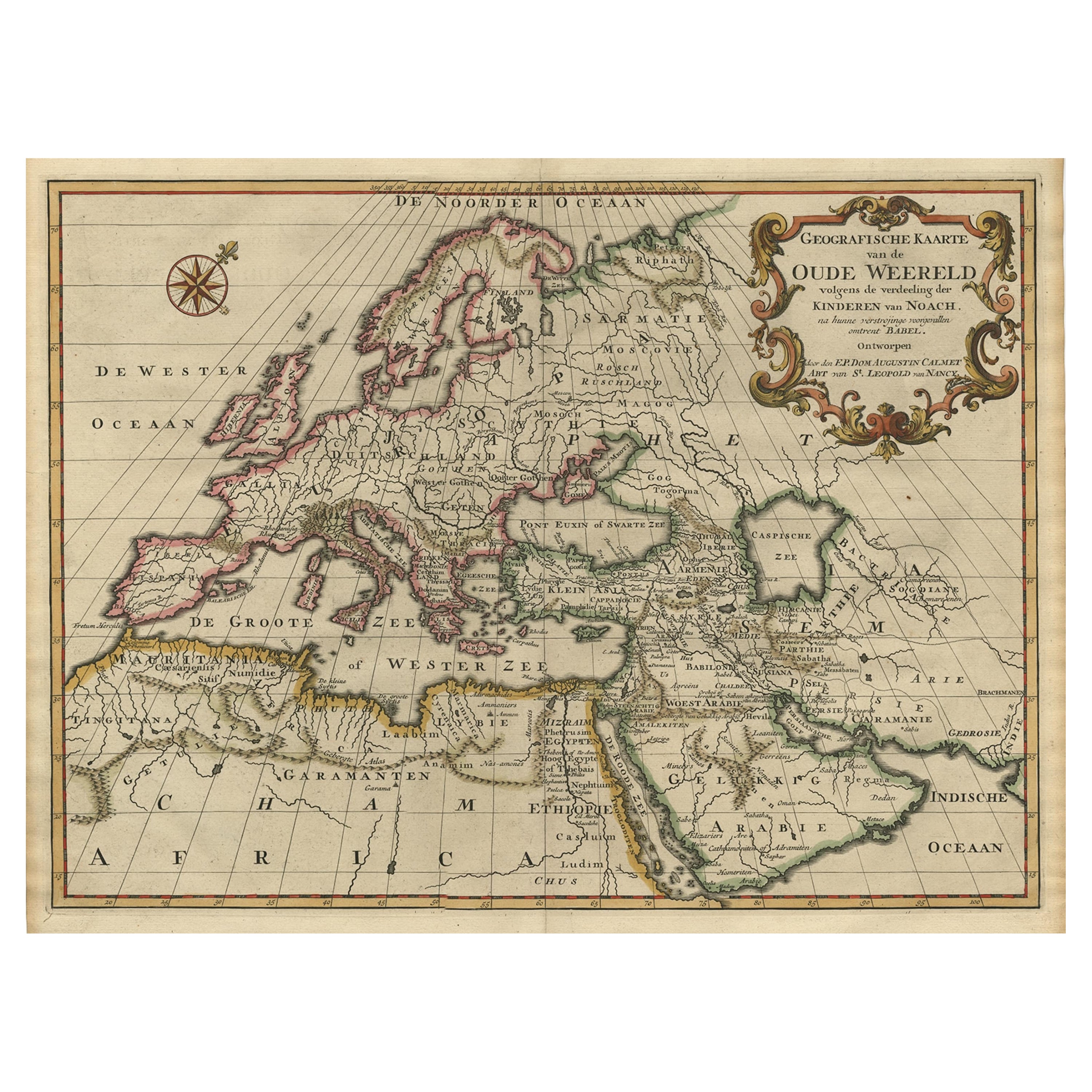
Ancient World Map of Europe, Asia
Northern Africa with Ancient Names, 1725
Located in Langweer, NL
Antique map titled 'Geografische Kaarte van de Oude Weereld (..).'
Original antique map of the ancient world depicting Europe, Asia, and northern Africa with ancient place names....
Category
Antique 1720s French Maps
Materials
Paper
$1,194 Sale Price
20% Off
Antique Map of Europe by Keizer
de Lat, 1788
Located in Langweer, NL
Antique map titled 'Kaartje van Europa (..)'. Uncommon original antique map of Europe. This map originates from 'Nieuwe Natuur- Geschied- en Handelkundige Zak- en Reisatlas' by Gerri...
Category
Antique Late 18th Century Maps
Materials
Paper

$382 Sale Price
20% Off
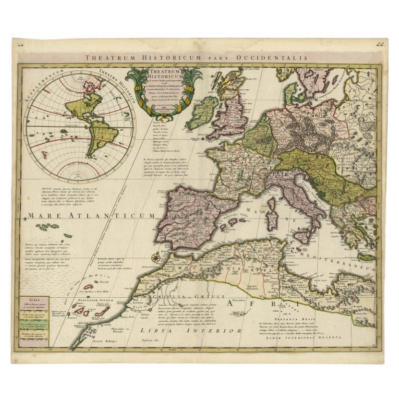
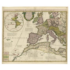
Finely Engraved Antique Map of Europe with inset of America, c.1745
By Guillaume De L
Isle
Located in Langweer, NL
Antique map titled 'Theatrum Historicum pars Occidentalis.' Finely engraved historical map with a profusion of details. It shows western Europe and the northern Mediterranean basin a...
Category
Antique 18th Century Maps
Materials
Paper
Antique Map of Europe by Hederichs, circa 1740
Located in Langweer, NL
Antique map titled 'Europa Christiani Orbis Domina'. Rare miniature map of Europe. This map originates from 'Anleitung Zu den fürnehmsten Historischen Wissenschaften, Benanntlich Der...
Category
Antique Mid-18th Century Maps
Materials
Paper

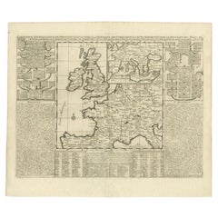
Antique Map of the British Isles and Part of Europe by Chatelain, c.1720
Located in Langweer, NL
Antique map titled 'Carte pour l'Intelligence de l'Histoire d'Angleterre (..)'. Decorative map showing the British Isles and the various regions conquered in Europe. Includese two elaborate family trees for the House of York...
Category
Antique 18th Century Maps
Materials
Paper
You May Also Like
17th Century Nicolas Visscher Map of Southeastern Europe
Located in Hamilton, Ontario
A beautiful, highly detailed map of southeastern Europe by Nicolas Visscher. Includes regions of Northern Italy (showing the cities Bologna, Padua, and Venice), Bohemia, Austria (sho...
Category
Antique 17th Century Dutch Maps
Materials
Paper

$1,350 Sale Price
38% Off
Southern
Eastern Europe: A Large 17th C. Hand-colored Map by Sanson
Jaillot
By Nicolas Sanson
Located in Alamo, CA
This large hand-colored map entitled "Estats de L'Empire des Turqs en Europe, ou sont les Beglerbeglicz our Gouvernements" was originally created by Nicholas Sanson d'Abbeville and t...
Category
Antique 1690s French Maps
Materials
Paper

$1,740 Sale Price
20% Off
17th Century Map of Denmark by French Cartographer Sanson, Dated 1658
By Nicolas Sanson
Located in Copenhagen, K
17th century map of Denmark by French cartographer Sanson.
Nicolas Sanson (20 December 1600-7 July 1667) was a French cartographer, termed by some the creator of French geography an...
Category
Antique 17th Century French Maps
Materials
Paper

Vintage Reproduction 17th Century Map of Europe, American, Cartography, Blaeuw
Located in Hele, Devon, GB
This is a vintage reproduction map of Europe. An American, paper stock cartography print in frame after the work by Blaeuw, dating to the late 20t...
Category
Late 20th Century Central American Mid-Century Modern Maps
Materials
Glass, Wood, Paper

Prussia, Poland, N. Germany, Etc: A Hand-colored 17th Century Map by Janssonius
By Johannes Janssonius
Located in Alamo, CA
This is an attractive hand-colored copperplate engraved 17th century map of Prussia entitled "Prussia Accurate Descripta a Gasparo Henneberg Erlichensi", published in Amsterdam by Joannes Janssonius in 1664. This very detailed map from the golden age of Dutch cartography includes present-day Poland, Latvia, Lithuania, Estonia and portions of Germany. This highly detailed map is embellished by three ornate pink, red, mint green and gold...
Category
Antique Mid-17th Century Dutch Maps
Materials
Paper

$1,020 Sale Price
20% Off
1718 Ides
Witsen Map "Route D
amsterdam a Moscow Et De La Ispahan Et Gamron
Located in Norton, MA
1718 Ides & Witsen map, entitled
"Route D'Amsterdam A Moscow Et De La Ispahan Et Gamron,"
Ric.b005
Subject: Eastern Europe and Central Asia
Period: 1718 (published)
Publicati...
Category
Antique Early 18th Century Dutch Maps
Materials
Paper

More Ways To Browse
Sea Monster
Iceland Antique
Icelandic Antique
Couch Console
Sterling Silver Flatware Service For 12
Antique Dining Tables With Leaves
Decorative Wall Panels
Frank Lloyd Wright For Cassina
Natural Curved
Spanish Wool Rug
Leather Pouf And Ottomans
Low Side Tables
Set Of Four Italian Dining Chairs
Silk Runner Carpet
18th Century Blue And White Porcelain
3x5 Rugs
Italian Lacquer Dining Room Sets
Round Brass Table