Want more images or videos?
Request additional images or videos from the seller
1 of 2
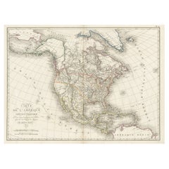
1842 Map of Lewis and Clark
s Expedition of North America
$3,450List Price
About the Item
- Dimensions:Height: 22 in (55.88 cm)Width: 29 in (73.66 cm)Depth: 1.75 in (4.45 cm)
- Materials and Techniques:
- Place of Origin:
- Period:
- Date of Manufacture:1842
- Condition:
- Seller Location:Colorado Springs, CO
- Reference Number:Seller: M1491stDibs: LU90976106623
About the Seller
4.9
Gold Seller
Premium sellers maintaining a 4.3+ rating and 24-hour response times
Established in 2010
1stDibs seller since 2011
473 sales on 1stDibs
Typical response time: 4 hours
Authenticity Guarantee
In the unlikely event there’s an issue with an item’s authenticity, contact us within 1 year for a full refund. DetailsMoney-Back Guarantee
If your item is not as described, is damaged in transit, or does not arrive, contact us within 7 days for a full refund. Details24-Hour Cancellation
You have a 24-hour grace period in which to reconsider your purchase, with no questions asked.Vetted Professional Sellers
Our world-class sellers must adhere to strict standards for service and quality, maintaining the integrity of our listings.Price-Match Guarantee
If you find that a seller listed the same item for a lower price elsewhere, we’ll match it.Trusted Global Delivery
Our best-in-class carrier network provides specialized shipping options worldwide, including custom delivery.You May Also Like
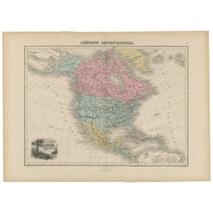
Antique Map of North America by Pierre M. Lapie, Paper, France, 1842
Located in Langweer, NL
Antique map titled 'Carte de l'Amérique septentrionale'. Map of North America, with an inset map of the Aleutian Islands. This map originates from 'Atlas universel de géographie anci...
Category
Antique Mid-19th Century French Maps
Materials
Paper

$467 Sale Price
35% Off
H 26.78 in W 19.89 in D 0.02 in
Antique Map of South America by Lapie
1842
Located in Langweer, NL
Antique map titled 'Carte Générale de l'Amérique Meridionale'. Map of South America. This map originates from 'Atlas universel de géographie ancienne et moderne (..)' by Pierre M. La...
Category
Antique Mid-19th Century Maps
Materials
Paper

Antique Map of North America, 1821
Located in Langweer, NL
Antique map of America titled 'Carte de l'Amerique septentrionale'. Scarce map of North America, shortly after the Louisiana Purchase and the first ...
Category
Antique 19th Century French Maps
Materials
Paper
Breda North Brabant Map, Published in 1842 – Antique Dutch Folding Map
Located in Langweer, NL
Breda North Brabant Map 1842 – Antique Dutch Folding Map
This antique folding map, titled “Kaart van het Arrondissement Breda in de Provincie Noord-Braband”, depicts the city of Bre...
Category
Antique Mid-19th Century Dutch Maps
Materials
Paper
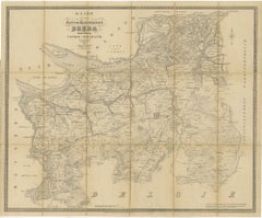
$1,679
H 28.35 in W 34.65 in D 0.01 in
University Chart “Black Map of North America
Located in Godshill, Isle of Wight
University Chart “Black Map of North America
W&A K Johnston’s Charts of Physical Maps By G W Bacon,
This is a Black Physical map of North A...
Category
Early 20th Century Industrial Maps
Materials
Linen

Antique 1842 Map of Turkey and Greece by Pierre M. Lapie, 68x50.5 cm
By Pierre M. Lapie
Located in Langweer, NL
Antique map titled 'Carte de la Turquie d'Europe et de la Grèce Moderne'. Map of Turkey and Greece. This map originates from 'Atlas universel de géographie ancienne et moderne (..)' ...
Category
Antique 19th Century French Maps
Materials
Paper
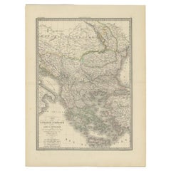
$297
H 26.78 in W 19.89 in D 0.01 in
Antique Map of the United States by Pierre M. Lapie, Wall Art, 1842
Located in Langweer, NL
Antique map titled 'Carte des États-Unis d'Amérique'. Map of the United States of America (USA). This map originates from 'Atlas universel...
Category
Antique Mid-19th Century French Maps
Materials
Paper

$435
H 19.89 in W 26.78 in D 0.02 in
Decorative Dutch Antique Map of North and South America, 1841
Located in Langweer, NL
Description: Antique map titled 'Amerika'. Small map of North and South America.
This map originates from the Dutch publication 'De Aarde, beschouwd in haren Natuurlijken Toestan...
Category
Antique 1840s Maps
Materials
Paper
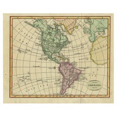
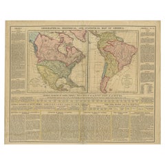
Antique Map of North and South America by Walker, 1828
Located in Langweer, NL
Antique map titled 'Geographical, Historical and Statistical Map of America'. Two maps on one sheet depicting North and South America. Text provides a lot of information about the Am...
Category
Antique 19th Century Maps
Materials
Paper
Antique Map of North and Central America by Migeon
1880
By J. Migeon
Located in Langweer, NL
Antique map titled 'Amérique Septentrionale'. Old map of North and Central America. With a decorative vignette of the Niagara Falls. This map originates from 'Géographie Universelle ...
Category
Antique Late 19th Century French Maps
Materials
Paper
More From This Seller
View All1868 "Lloyd
s Topographical Railway Map of North America..." Hanging Wall Map
Located in Colorado Springs, CO
Presented is “Lloyd's Topographical Railway Map of North-America, or the United States Continent in 1900.” This map was published by J. T. Lloyd, in New York, in 1868. A large, hangi...
Category
Antique 1860s American Late Victorian Maps
Materials
Linen, Paper

1864 Map of North America, Antique Hand-Colored Map, by Adolphe Hippolyte Dufour
Located in Colorado Springs, CO
Offered is a map of North America entitled Amerique du Nord from 1864. This rare, separately published wall map was produced by Adolphe Hippolyte Dufour. This map includes vibrant an...
Category
Antique 1860s French Maps
Materials
Paper

1842 Wall Map of the United States by J. H. Young, Published by S. A. Mitchell
Located in Colorado Springs, CO
Presented is an 1842 hanging “Map of the United States,” engraved by J. H. Young and published by Samuel Augustus Mitchell, Philadelphia. This is a beautiful example of the rare 1842...
Category
Antique 1840s American Maps
Materials
Paper

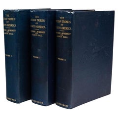
The Indian Tribes of North America by Thomas McKenney and James Hall, 3 Vols.
By McKenney
Hall
Located in Colorado Springs, CO
McKenney, Thomas L. and James Hall. The Indian Tribes of North America. With Biographical Sketches and Anecdotes of The Principal Chiefs. Edinburgh: John Grant, 1933-4. A New Edition...
Category
Vintage 1930s Scottish Books
Materials
Fabric, Paper
1859 "Map of the United States of America..." by J. H. Colton
By J.H. Colton
Located in Colorado Springs, CO
Presented is an 1859 “Map of the United States of America, the British Provinces, Mexico, the West Indies and Central America with Part of...
Category
Antique 1850s American Maps
Materials
Paper

1854 Map of Massachusetts, Connecticut and Rhode Island, Antique Wall Map
Located in Colorado Springs, CO
This striking wall map was published in 1854 by Ensign, Bridgman & Fanning and has both full original hand-coloring and original hardware. This impression is both informative and highly decorative.
The states are divided into counties, outlined in red, green, and black, and subdivided into towns. Roads, canals, and railroad lines are prominently depicted, although they are not all labeled. The mapmakers also marked lighthouses, banks, churches, and prominent buildings, with a key at right. The map is an informative and comprehensive overview of the infrastructural development of New England prior to the Civil War. Physical geographies depicted include elevation, conveyed with hachure marks, rivers and lakes. The impression features an inset map of Boston...
Category
Antique 19th Century American Maps
Materials
Paper
