Want more images or videos?
Request additional images or videos from the seller
1 of 2
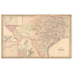
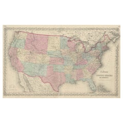
1856 Map of the State of Texas by J. H. Colton
$1,850List Price
About the Item
- Dimensions:Height: 24 in (60.96 cm)Width: 33 in (83.82 cm)Depth: 2 in (5.08 cm)
- Materials and Techniques:Paper,Engraved
- Place of Origin:
- Period:
- Date of Manufacture:1856
- Condition:
- Seller Location:Colorado Springs, CO
- Reference Number:Seller: m1831stDibs: LU90976104163
About the Seller
4.9
Platinum Seller
Premium sellers with a 4.7+ rating and 24-hour response times
Established in 2010
1stDibs seller since 2011
474 sales on 1stDibs
Typical response time: 9 hours
Authenticity Guarantee
In the unlikely event there’s an issue with an item’s authenticity, contact us within 1 year for a full refund. DetailsMoney-Back Guarantee
If your item is not as described, is damaged in transit, or does not arrive, contact us within 7 days for a full refund. Details24-Hour Cancellation
You have a 24-hour grace period in which to reconsider your purchase, with no questions asked.Vetted Professional Sellers
Our world-class sellers must adhere to strict standards for service and quality, maintaining the integrity of our listings.Price-Match Guarantee
If you find that a seller listed the same item for a lower price elsewhere, we’ll match it.Trusted Global Delivery
Our best-in-class carrier network provides specialized shipping options worldwide, including custom delivery.You May Also Like
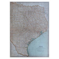
Large Antique Map of Texas with Panhandle
Bay Inset Maps, Colton, 1873
Located in Langweer, NL
Large Antique Map of Texas with Panhandle & Bay Inset Maps, Colton, 1873
This richly detailed and visually striking antique map of Texas was pub...
Category
Antique 1870s Maps
Materials
Paper
$867
H 17.52 in W 27.6 in D 0.01 in
Original Antique Map of the American State of Texas ( Eastern Part ), 1903
Located in St Annes, Lancashire
Antique map of Texas ( Eastern part )
Published By A & C Black. 1903
Original colour
Good condition
Unframed.
Free shipping
Category
Antique Early 1900s English Maps
Materials
Paper
$49
Free Shipping
H 16.25 in W 11.5 in D 0.07 in
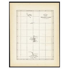
Antique Map of the Bonin Islands by Hawks, 1856
Located in Langweer, NL
Antique map titled 'Chart of the Bonin Group of Islands.' The Bonin Islands, known in Japan as the Ogasawara Group are an archipelago of over 30 subtropical and tropical islands, som...
Category
Antique 19th Century Maps
Materials
Paper
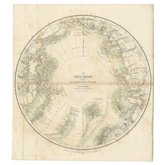
Antique Map of the North Pole by Fullarton, 1856
Located in Langweer, NL
Antique map titled 'The Arctic Regions showing the North-West Passage of Captain R. McClure'. Old map of the North Pole, displaying the Northwest Passage di...
Category
Antique 19th Century Maps
Materials
Paper
Antique Map Colton
s United States of America
Located in Langweer, NL
Antique map titled 'Colton's United States of America'. Show railroads, canals, state capitals, major cities and towns, military posts, historic trails, Pony Express and U.S. mail routes; Dakota [Territory] extending deep into Nebraska, and Idaho [Territory] encompassing [modern day] Montana and Wyoming; Indian Territory...
Category
Antique Mid-19th Century Maps
Materials
Paper
1858 Colton
s Map of New York, Ric.B011
Located in Norton, MA
An 1858 Colton's map of New York
Ric.b011
Colton’s New York, 1858 - A large original color engraved and very detailed map of the state of New York,...
Category
Antique 19th Century Unknown Maps
Materials
Paper

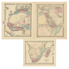
Set of Three Antique Maps of Africa by Colton (circa 1855)
Located in Langweer, NL
Set of three individual maps of Africa including 'North West Africa', 'North Eastern Africa' and 'Southern Africa'. All three maps are surrounded by Colton's typical spiral motif border. Colton names numerous African tribes and nations throughout. An interesting set of maps...
Category
Antique Mid-19th Century Maps
Materials
Paper
Colton
s Map of Illinois, with an Inset of Chicago
Located in Langweer, NL
Antique map titled 'Colton's Illinois'. Antique map of Illinois, a state in the Midwestern United States. With an inset map of of Cook County &...
Category
Antique Mid-19th Century Maps
Materials
Paper
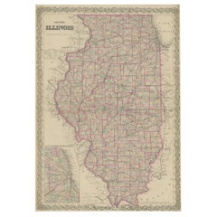
$228 Sale Price
20% Off
H 26.78 in W 17.52 in D 0.02 in
Arkansas Map by Colton, USA Published c.1864 – Hand-Colored County Map
Located in Langweer, NL
Arkansas Map by Colton, USA Published c.1864 – Hand-Colored County Map
This is a finely engraved and hand-colored map titled Arkansas, published by G.W. & C.B. Colton & Co. in New Y...
Category
Antique Mid-19th Century American Maps
Materials
Paper
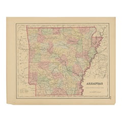
$392
H 14.06 in W 18 in D 0.01 in
Antique Map of the Eastern United States with Inset Map of Texas
Located in Langweer, NL
Antique map titled 'Verein-Staaten von Nord-America mit Ausnahme Florida's und der Westlichen Territorien'. This map extends as far west as Louisiana and only includes the northern p...
Category
Antique Mid-19th Century Maps
Materials
Paper

$513 Sale Price
20% Off
H 14.65 in W 17.84 in D 0.02 in
More From This Seller
View All1859 "Map of the United States of America..." by J. H. Colton
By J.H. Colton
Located in Colorado Springs, CO
Presented is an 1859 “Map of the United States of America, the British Provinces, Mexico, the West Indies and Central America with Part of...
Category
Antique 1850s American Maps
Materials
Paper

1856 "Map of the United States" by Ensign, Bridgeman, and Fanning
Located in Colorado Springs, CO
Presented is a scarce American wall map of the United States and Mexico issued by Ensign, Bridgman, and Fanning in 1856. As the title suggests, the map covers all of the United State...
Category
Antique 1850s American Victorian Maps
Materials
Paper

1904 "Nell
s Topographical Map of the State of Colorado"
Located in Colorado Springs, CO
This highly detailed pocket map is a topographical map of the state of Colorado by Louis Nell from 1904. The map "has been compiled from all available...
Category
Antique Early 1900s American Maps
Materials
Leather, Paper

1837 Mitchell
s "Tourist
s Pocket Map of the State of Virginia" by J.H. Young
Located in Colorado Springs, CO
This is J. H. Young's pocket map of the Virginia, which shows county development current to 1835. The map was engraved by E. Yeager and F. Dankworth and published by S. A. Mitchell. ...
Category
Antique 1830s American Maps
Materials
Paper

1856 U.S. Coast Survey Map of Chesapeake Bay and Delaware Bay
Located in Colorado Springs, CO
Presented is U.S. Coast Survey nautical chart or maritime map of Chesapeake Bay and Delaware Bay from 1856. The map depicts the region from Susquehanna, Maryland to the northern Outer Banks in North Carolina. It also shows from Richmond and Petersburg, Virginia to the Atlantic Ocean. The map is highly detailed with many cities and towns labeled throughout. Rivers, inlets, and bays are also labeled. Various charts illustrating more specific parts of the region are marked on the map using dotted lines. The lines form boxes, and the corresponding chart number and publication date are given. Extensive triangulation surveys were conducted the length of Chesapeake Bay and are illustrated here. Hampton Roads, Virginia is labeled, along with the James, York, and Rappahannock Rivers, which were all extensively surveyed.
The chart was published under the supervision of A. D. Bache, one of the most influential and prolific figures in the early history of the U.S. Coast Survey, for the 1856 Report of the Superintendent of the U.S. Coast Survey. Alexander Dallas Bache (1806-1867) was an American physicist, scientist, and surveyor. Bache served as the Superintendent of the U.S. Coast Survey from 1843 to 1865. Born in Philadelphia, Bache toured Europe and composed an important treatise on European Education. He also served as president of Philadelphia's Central High School and was a professor of natural history and chemistry at the University of Pennsylvania. Upon the death of Ferdinand Rudolph Hassler, Bache was appointed Superintendent of the United States Coast Survey.
The Office of the Coast Survey, founded in 1807 by President Thomas Jefferson and Secretary of Commerce Albert Gallatin...
Category
Antique 1850s American Maps
Materials
Paper

1847 Antique Map of Mexico, Texas and California by Samuel Augustus Mitchell
By Samuel Augustus Mitchell 1
Located in Colorado Springs, CO
Presented is the second edition of Samuel Augustus Mitchell's Map of Mexico, Including Yucatan & Upper California, an important map showing the progress of the Mexican-American War. ...
Category
Antique 1840s American Maps
Materials
Paper
