Items Similar to 1856 "Map of the United States" by Ensign, Bridgeman, and Fanning


Want more images or videos?
Request additional images or videos from the seller
1 of 9
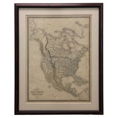
1856 "Map of the United States" by Ensign, Bridgeman, and Fanning
$15,500
£11,706.64
€13,522.99
CA$21,837.29
A$23,387.75
CHF 12,573.09
MX$284,057.87
NOK 158,867.15
SEK 145,454.69
DKK 101,041.44
About the Item
Presented is a scarce American wall map of the United States and Mexico issued by Ensign, Bridgman, and Fanning in 1856. As the title suggests, the map covers all of the United States, as well as Mexico, Cuba, and Central America as far as Panama. Additional iInset maps in the lower left illustrate the World on a double hemispheric projection and the West Indies.
The focus of the map is the westward expansion and settlement of the United States. The map was updated accordingly, to indicate territorial and border changes west of the Mississippi River. In this 1856 printing, Texas is configured with borders established as a result of the Compromise of 1850 and New Mexico has added new territory thanks to the Gadsden Purchase. The borders of Kansas and Nebraska adhere to the Kansas-Nebraska Act of May 30, 1854 in which Nebraska stretches to the Canadian border.
Published at the tail’s end of the gold rush, the gold region in the Sacramento Valley, California is highlighted. The map notes exploration and travel routes to the west, including Fremont's Route, The Oregon Trail, and the Santa Fe Caravan route. American Indian lands are identified throughout.
This map was first published in 1849 by Horace Thayer and Edward Hooker Ensign, who had it engraved by John M. Atwood. The imprint varied over the years, with the 1851 edition also attributed to “Ensign and Thayer,” an 1853 edition attributed solely to Horace Thayer, and editions starting in 1855 attributed to “Ensign, Bridgeman, and Fanning,” like the present example. The map proved popular due to its more manageable size and was updated annually through at least 1857.
CONDITION:
Very good condition considering age and past use. Engraved map, with hand coloring. Map is dated 1855, but published in 1856. Paper is mostly healthy, with mild to moderate toning and scattered stains. Previously restored and stabilized, now newly backed onto archival linen.
Map has been artfully framed to conservation standards in a custom wooden frame, with acid-free mats, and UV glass.
Framed Dimensions: 54 1/4" H x 50" W x 3 1/4" D.
Accompanied by our company's letter of authenticity.
- Dimensions:Height: 54.25 in (137.8 cm)Width: 50 in (127 cm)Depth: 3.25 in (8.26 cm)
- Style:Victorian (Of the Period)
- Materials and Techniques:Paper,Engraved
- Place of Origin:
- Period:
- Date of Manufacture:1856
- Condition:Additions or alterations made to the original: Framed to archival and conservation standards by Art Source International Framing in Boulder, CO in October of 2024. Wear consistent with age and use. Minor structural damages. Minor fading.
- Seller Location:Colorado Springs, CO
- Reference Number:Seller: M3651stDibs: LU909746601372
About the Seller
4.9
Platinum Seller
Premium sellers with a 4.7+ rating and 24-hour response times
Established in 2010
1stDibs seller since 2011
473 sales on 1stDibs
Typical response time: 4 hours
- ShippingRetrieving quote...Shipping from: Colorado Springs, CO
- Return Policy
More From This Seller
View All1859 "Map of the United States of America..." by J. H. Colton
By J.H. Colton
Located in Colorado Springs, CO
Presented is an 1859 “Map of the United States of America, the British Provinces, Mexico, the West Indies and Central America with Part of...
Category
Antique 1850s American Maps
Materials
Paper

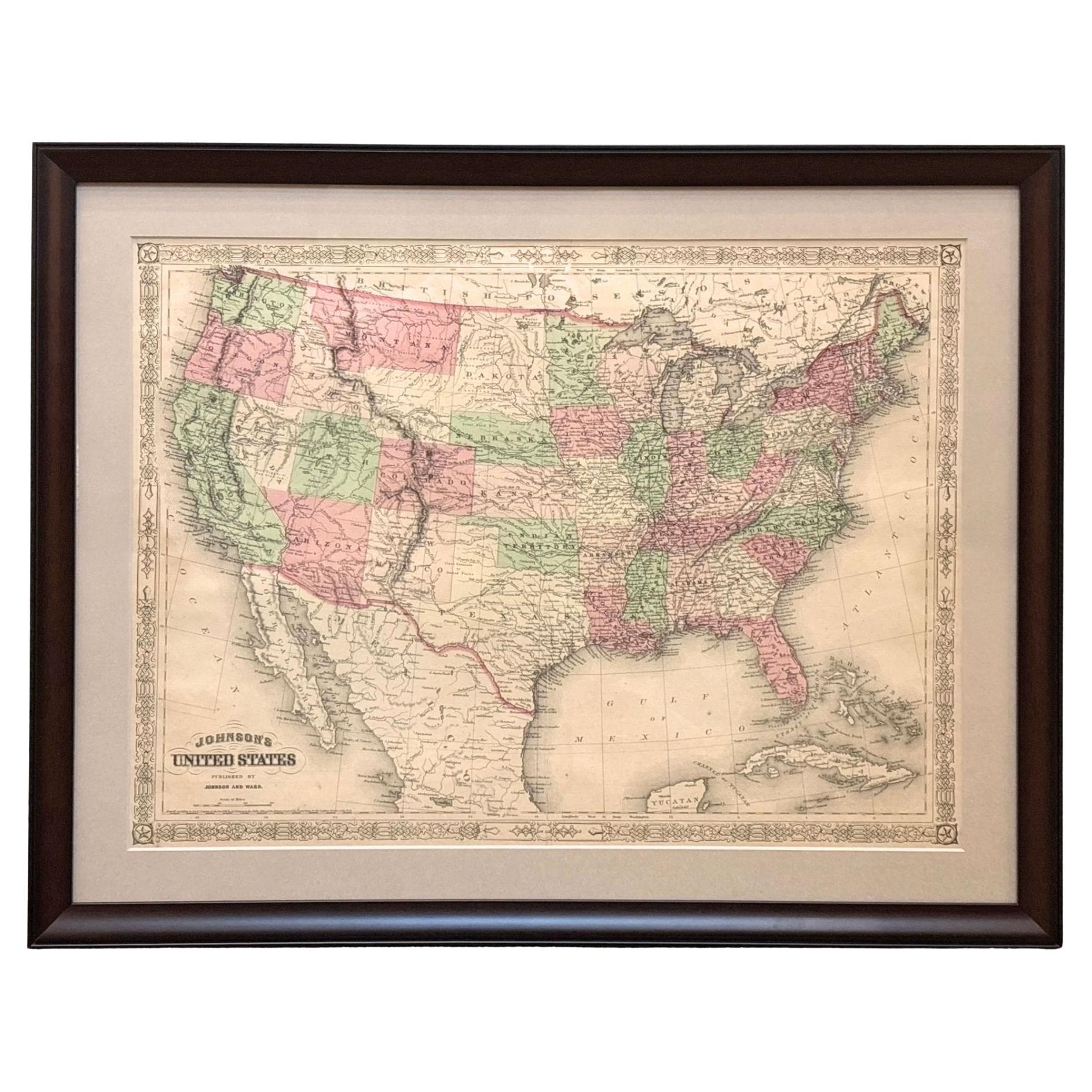
1866 "Johnson
s United States" Map, Published by Johnson and Ward
Located in Colorado Springs, CO
Presented is a detailed map of the United States by A. J. Johnson. Spanning the whole of the continental United States, as well as adjacent parts of Canada and Mexico, the map reflec...
Category
Antique 1860s American Victorian Maps
Materials
Paper

1864 Map of North America, Antique Hand-Colored Map, by Adolphe Hippolyte Dufour
Located in Colorado Springs, CO
Offered is a map of North America entitled Amerique du Nord from 1864. This rare, separately published wall map was produced by Adolphe Hippolyte Dufour. This map includes vibrant an...
Category
Antique 1860s French Maps
Materials
Paper

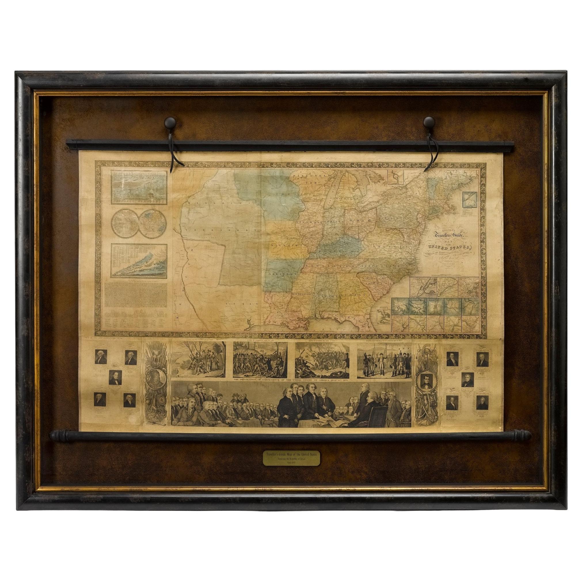
1845 "Ensign
s Travellers
Guide and Map of the United States" Hand-Colored Map
Located in Colorado Springs, CO
This is an exquisite and dramatic steel-engraved wall map of the United States, published by T.
E. H. Ensign in 1845. The map depicts the development and settlement of the Unit...
Category
Antique 1840s American Victorian Maps
Materials
Paper

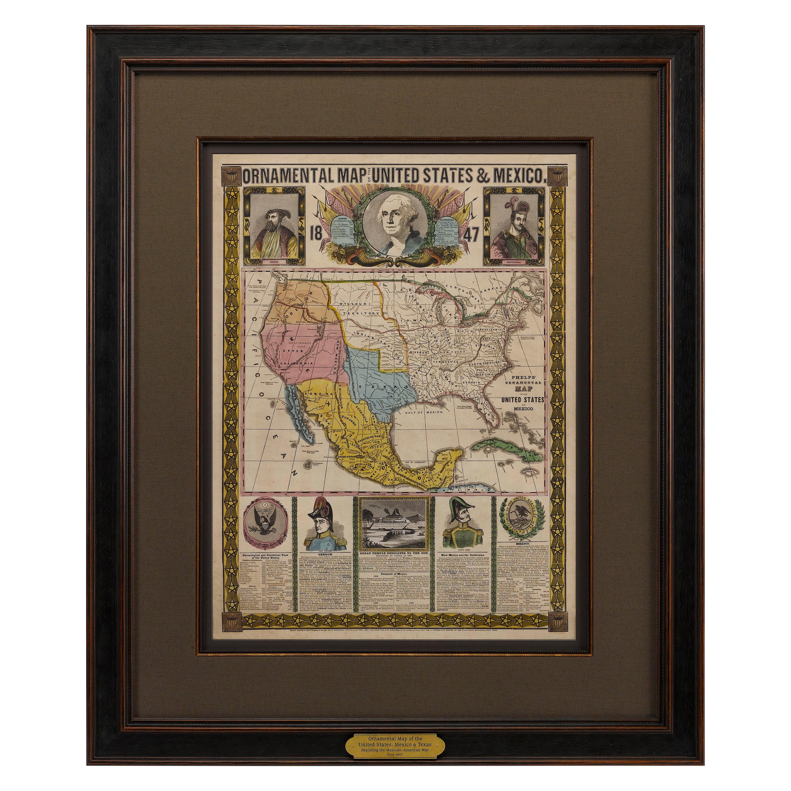
1847 Ornamental Map of the United States
Mexico by H. Phelps
Located in Colorado Springs, CO
Offered is an original 1847 ornamental map of the U.S. entitled "Ornamental Map of the United States
Mexico" by Humphrey Phelps. The map was issued as an act of Congress by Phelps on Fulton Street, New York. The broadside is elaborately hand-colored.
This is a very detailed and graphic propaganda map of the United States expressing U.S. dominance of the North American continent. The hand-colored map proclaims the Manifest Destiny, with the recent acquisition of Upper California and Texas at the conclusion of the Mexican-American War. The newly acquired land is boldly colored, standing in stark contrast to the rest of the U.S. The map details a potential route for a railroad running from New York City, to Buffalo, to Chicago, then west along the Oregon Trail to Oregon City. This route anticipates the construction of the transcontinental railroad by nearly 20 years.
The map includes elaborately detailed renderings of George Washington, Hernan Cortez, and Montezuma at top to represent European expansion to the Americas. At bottom are four inset designs with text showing the following: a chronological history of the U.S. beginning from settlement to the U.S. victory in the Mexican-American war; an illustration of General Zachary Taylor with details on the Oregon Territory; an illustration of the Aztec Temple of the Sun in Tenochtitlan and a chronology of the Conquest of the Aztec Empire under Cortez; a portrait of General Antonio Lopez de Santa Anna...
Category
Antique 1840s American Maps
Materials
Paper

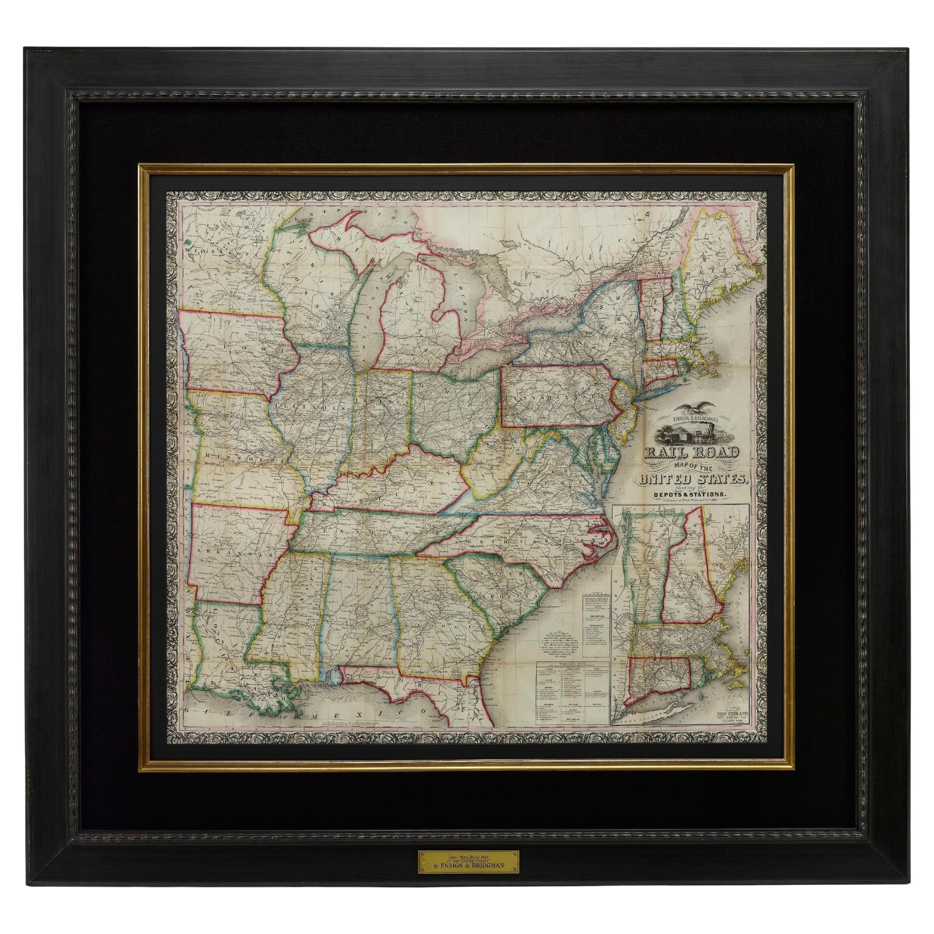
1866 Ensign
Bridgman
s Rail Road Map of the United States
Located in Colorado Springs, CO
Presented is an 1866 issue of “Ensign & Bridgeman’s Rail Road Map of the United States, showing Depots & Stations.” First published in 1856, this is the third edition, following anot...
Category
Antique 1860s American Late Victorian Maps
Materials
Paper

You May Also Like
Antique North America Map, USA, Canada, Mexico, Cartography, Colton, Victorian
Located in Hele, Devon, GB
This is an antique North America map. A USA, framed lithography atlas engraving of the continent by JH Colton, dating to the Victorian period and later, circa 1860.
Fascinating, large framed map...
Category
Antique Mid-19th Century American Victorian Maps
Materials
Paper

Antique Map of the United States by Balbi
1847
Located in Langweer, NL
Antique map titled 'Etats-Unis'. Original antique map of the United States. This map originates from 'Abrégé de Géographie (..)' by Ad...
Category
Antique Mid-19th Century Maps
Materials
Paper

$190 Sale Price
20% Off
Antique Map of the United States by Titus
1871
Located in Langweer, NL
Antique map titled 'The United States of America'. Original antique map of the United States. This map originates from 'Atlas of Prebl...
Category
Antique Late 19th Century Maps
Materials
Paper

$763 Sale Price
20% Off
Antique Map of the United States by Pierre M. Lapie, Wall Art, 1842
Located in Langweer, NL
Antique map titled 'Carte des États-Unis d'Amérique'. Map of the United States of America (USA). This map originates from 'Atlas universel...
Category
Antique Mid-19th Century French Maps
Materials
Paper

Framed 1838 North America
Recent Discoveries Map
Located in Stamford, CT
1838 map of North America & recent discoveries. Engraved color map by J. Wyld, London, England. This map shows Texas as a Republic without its panhandle.
Framed in brown carved wood...
Category
Antique 1830s American American Classical Maps
Materials
Glass, Wood, Paper
Original Antique Map of United States, Grattan and Gilbert, 1843
Located in St Annes, Lancashire
Great map of United States
Drawn and engraved by Archer
Published by Grattan and Gilbert. 1843
Original colour
Unframed.
Category
Antique 1840s English Maps
Materials
Paper
