Items Similar to 1857 Engraved Map of Russia, Finland
Scandinavia – Historic Print

Video Loading
Want more images or videos?
Request additional images or videos from the seller
1 of 11
1857 Engraved Map of Russia, Finland
Scandinavia – Historic Print
$403.82
£300.46
€340
CA$560.77
A$602.99
CHF 323.60
MX$7,193.20
NOK 4,070.34
SEK 3,722.33
DKK 2,591.39
About the Item
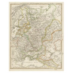
Antique Map of European Russia Including Scandinavia – Stieler Atlas 1857
This antique map titled "Europäisches Russland nebst Schweden und Norwegen" (European Russia together with Sweden and Norway) was published in 1857 by Justus Perthes in Gotha, Germany, for the Stieler’s Hand-Atlas. Drawn and engraved under the direction of F. von Stülpnagel, this map offers a comprehensive view of Northern and Eastern Europe during the mid-19th century.
The map covers an expansive region from Scandinavia in the northwest to the Ural Mountains in the east, and from the Arctic Ocean in the north to the Black Sea and Balkans in the south. It highlights the extent of the Russian Empire within Europe, as well as neighboring countries including Sweden, Norway, Finland, Poland, the Baltic states, Austria-Hungary, the Ottoman Empire, and parts of Germany and Central Europe.
Key cities such as St. Petersburg, Moscow, Warsaw, Riga, and Kiev are clearly labeled, along with major rivers including the Volga, Dnieper, and Don. Mountain ranges, railway lines, and political boundaries are finely engraved and enhanced with original hand coloring. The map also distinguishes between various Russian administrative divisions such as governments (Gouvernements) and includes a legend identifying capitals, fortresses, and religious centers.
This map reflects the political and territorial organization of Eastern Europe before the major upheavals of the late 19th and 20th centuries. It serves as an important reference for understanding historical borders, migration patterns, and regional influences of the Russian Empire during a period of growing expansion and modernization.
Collectors, historians, and map enthusiasts will appreciate the detailed craftsmanship, historical value, and aesthetic appeal of this finely produced example of 19th-century cartography.
Condition report:
Very good condition. Slight toning to edges consistent with age. Vertical centerfold as issued. No major tears or foxing. Hand coloring remains vivid and attractive.
Framing tips:
This map would display beautifully in a classic black or gold frame with a neutral mat. For a traditional setting, pair it with other European or Russian-themed antique maps from the same period.
Technique: Engraving with original hand coloring
Maker: F. von Stülpnagel, Gotha, Justus Perthes, 1857
- Dimensions:Height: 14.77 in (37.5 cm)Width: 17.88 in (45.4 cm)Depth: 0.01 in (0.2 mm)
- Materials and Techniques:Paper,Engraved
- Place of Origin:
- Period:
- Date of Manufacture:1858
- Condition:Very good condition. Slight toning to edges consistent with age. Vertical centerfold as issued. No major tears or foxing. Hand coloring remains vivid and attractive.
- Seller Location:Langweer, NL
- Reference Number:Seller: BG-05552-411stDibs: LU3054346101652
About the Seller
5.0
Recognized Seller
These prestigious sellers are industry leaders and represent the highest echelon for item quality and design.
Platinum Seller
Premium sellers with a 4.7+ rating and 24-hour response times
Established in 2009
1stDibs seller since 2017
2,832 sales on 1stDibs
Typical response time: 1 hour
- ShippingRetrieving quote...Shipping from: Langweer, Netherlands
- Return Policy
More From This Seller
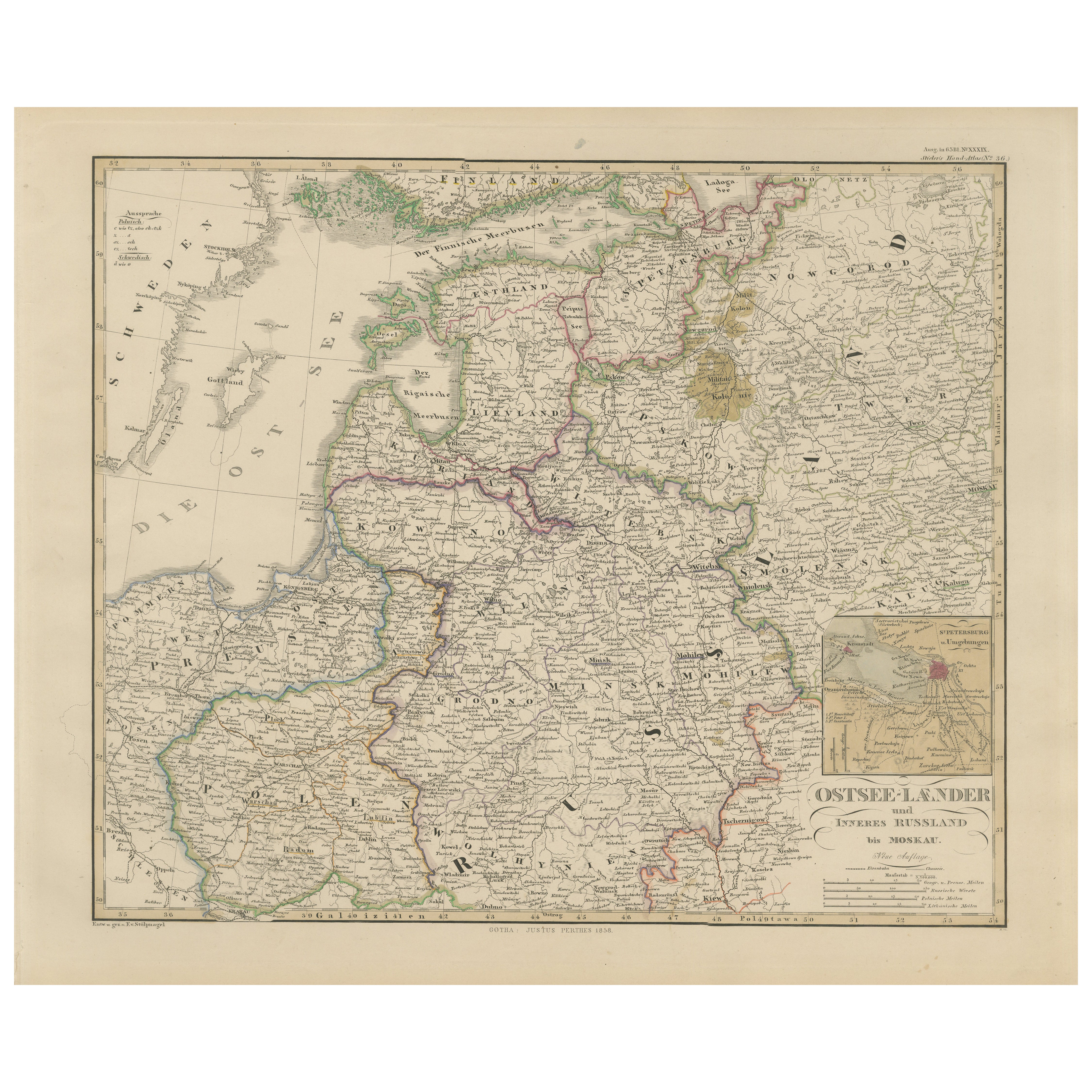
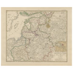
View All1858 Map of the Baltic States
Inner Russia to Moscow – Justus Perthes
Located in Langweer, NL
1858 Map of the Baltic States & Inner Russia to Moscow – Justus Perthes
Description:
Antique map titled "Ostsee-Länder und das Innere Russland bis Moskau," published by Justus Perth...
Category
Antique Mid-19th Century German Maps
Materials
Paper
Antique 1842 Map of Russia in Europe by Pierre M. Lapie
Located in Langweer, NL
Antique map titled 'Carte de la Russie d'Europe'. Map of Russia in Europe. This map originates from 'Atlas universel de géographie ancienne et moderne (....
Category
Antique 19th Century French Maps
Materials
Paper

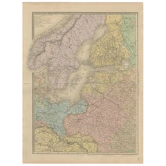
Antique Map of Scandinavia and the Baltic – Andriveau-Goujon, circa 1860s
Located in Langweer, NL
Antique Map of Scandinavia and the Baltic – Andriveau-Goujon, circa 1860s
This impressive antique map presents Northern Europe, focusing on the Scandinavian Peninsula, the Baltic re...
Category
Antique Mid-19th Century French Maps
Materials
Paper
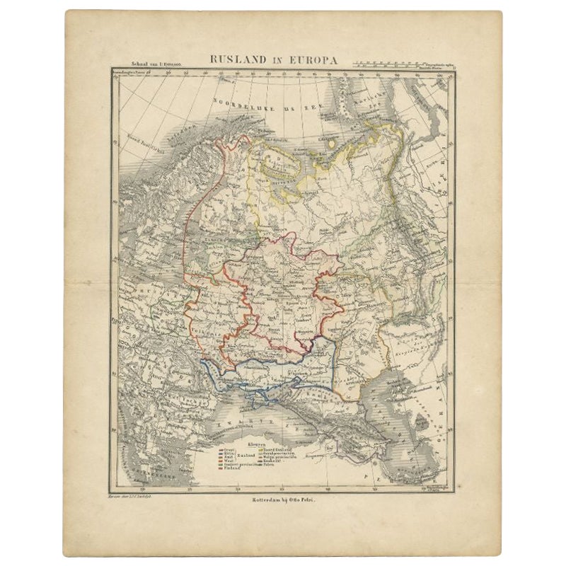
Antique Map of Russia in Europe by Petri, c.1873
Located in Langweer, NL
Antique map titled 'Rusland in Europa'. Old map depicting Russia in Europe. This map originates from 'School-Atlas van alle Deelen der Aarde'. Artists and Engravers: Published by O. ...
Category
Antique 19th Century Maps
Materials
Paper
$92 Sale Price
20% Off
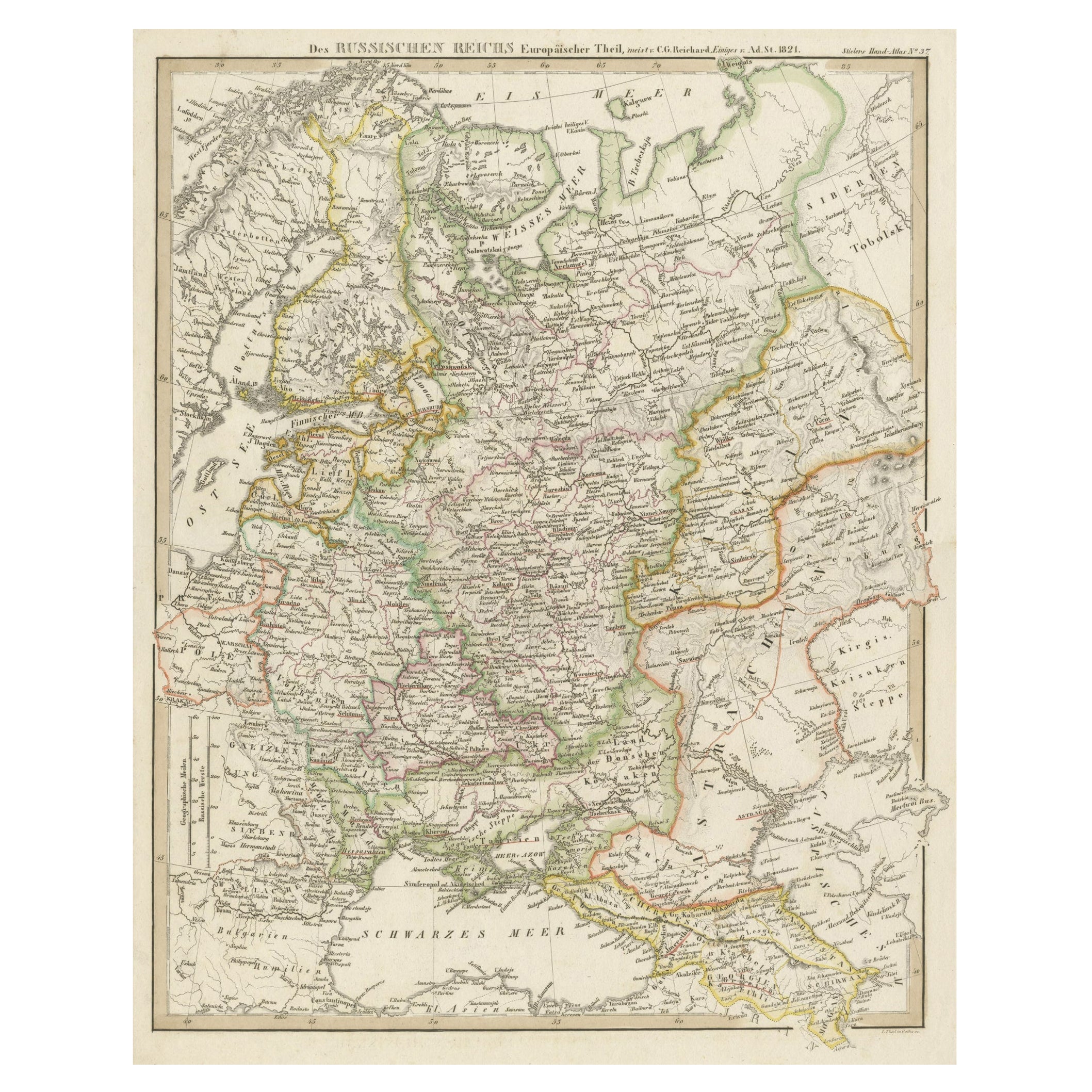
Original Antique German Map of the Russian Empire in Europe, ca.1825
Located in Langweer, NL
Antique map titled 'Des Russischen Reichs - Europäische Theil'.
Original antique map of the Russian Empire in Europe. This map originates from 'Stielers Handatlas'. Published circa...
Category
Antique 1820s Maps
Materials
Paper
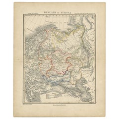
Antique Map of Russia in Europe and Poland from an d Old Dutch Atlas, 1852
Located in Langweer, NL
Description: Antique map titled 'Europeesch Rusland en Polen'.
Map of Russia in Europe and Poland. This map originates from 'School-Atlas van alle deelen der Aarde' by Otto Petri...
Category
Antique 1850s Maps
Materials
Paper

You May Also Like
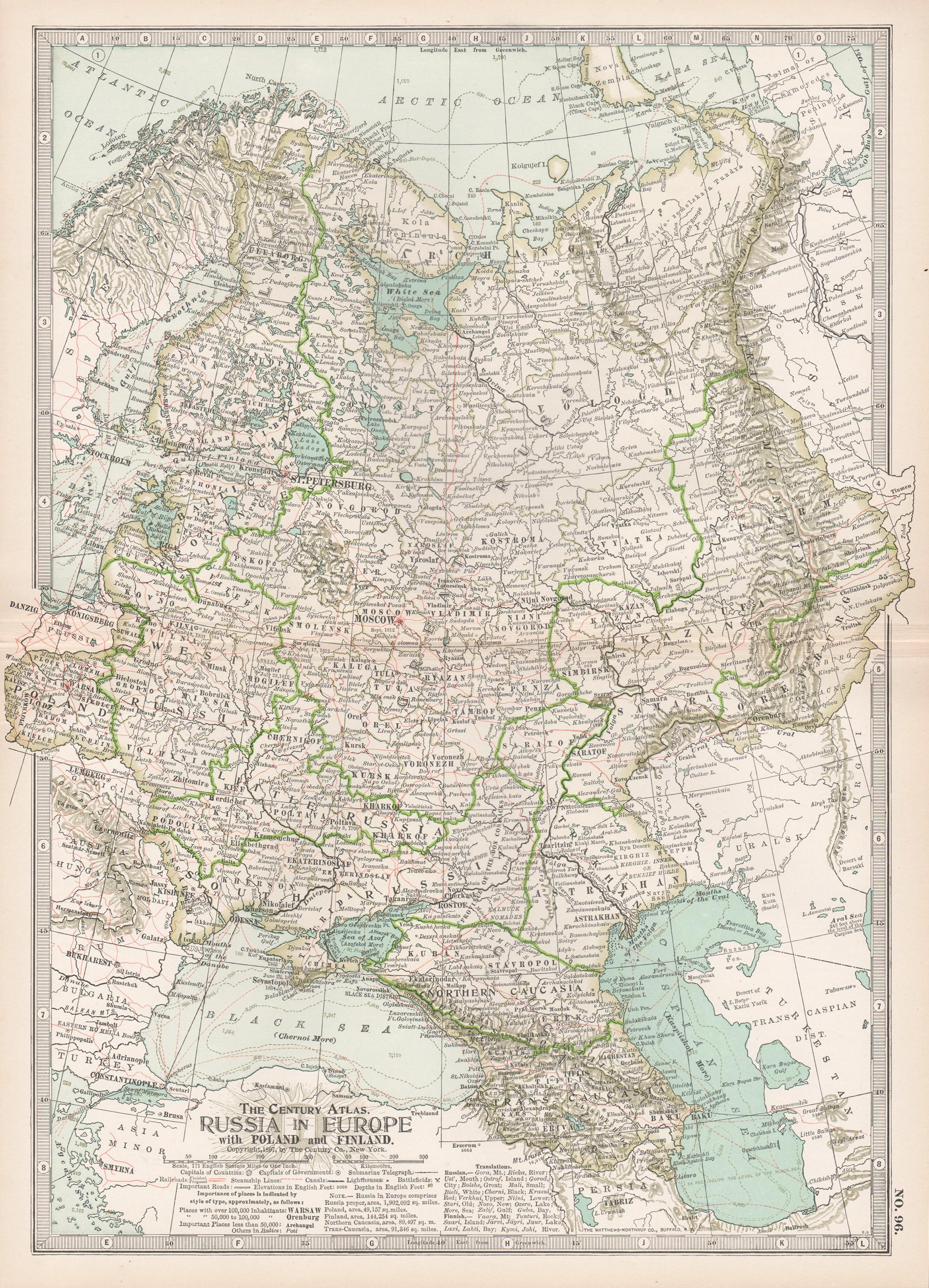
Russia in Europe with Poland and Finland. Century Atlas antique vintage map
Located in Melbourne, Victoria
'The Century Atlas. Russia in Europe with Poland and Finland'
Original antique map, 1903.
Central fold as issued. Map name and number printed on the reverse corners.
Sheet 40cm by ...
Category
Early 20th Century Victorian More Prints
Materials
Lithograph

Russia, Western and Southern Part. Century Atlas antique vintage map
Located in Melbourne, Victoria
'The Century Atlas. Russia, Western and Southern Part'
Original antique map, 1903.
Inset map tilted 'St Petersburg and Environs'.
Central fold as issued. Map name and number printe...
Category
Early 20th Century Victorian More Prints
Materials
Lithograph

1849 Map of "Europaische Russland",
Meyer Map of European Russia
, Ric. R017
Located in Norton, MA
1849 Map of
"Europaische Russland"
( Meyer Map of European Russia)
Ric.r017
A lovely map of European Russia dating to 1849 by Joseph Meyer. It covers the European portions of...
Category
Antique 19th Century Unknown Maps
Materials
Paper

1853 Map of "Russia in Europe Including Poland" Ric.r016
Located in Norton, MA
Description
Russia in Europe incl. Poland by J Wyld c.1853
Hand coloured steel engraving
Dimension: Paper: 25 cm W x 33 cm H ; Sight: 22 cm W x 28 cm H
Condition: Good ...
Category
Antique 19th Century Unknown Maps
Materials
Paper

1832 Large Map "Russian
Poland" Ric. R0012
Located in Norton, MA
Large map 1832
"Russian & Poland"
Ric.r0012
Russia & Poland, by J. Arrowsmith. London, pubd. 15 Feby. 1832 by J. Arrowsmith, 35 Essex Street, Strand., ...
Category
Antique 19th Century Unknown Maps
Materials
Paper

Map of Russia - Original Etching - Late 19th Century
Located in Roma, IT
This Map of Russia is an etching realized by an anonymous artist.
The state of preservation of the artwork is good with some small diffused stains.
Sheet dimension:27.5 x 44
At t...
Category
Late 19th Century Modern Figurative Prints
Materials
Etching
More Ways To Browse
Beni Ourain Rugs
Glass Top Wood Base Coffee Tables
T Chair
Pair Of Danish Chairs
Veneer Dining Tables
1970 Italian Armchair
Furniture Uk
House Of Denmark Table And Chairs
Louis Marble Top Side Table
Antique Russian Rugs
Baker Furniture By
For Kids
Sterling Silver Flatware Set Service For 12
Tufted Bar
Pair Of French Antique Armchairs
1970s Brass Glass Coffee Table
Antique Column Base
Charles Rennie Mackintosh For Cassina