Items Similar to 1858 Map of South France with Corsica – Marseille to Italian Border

Video Loading
Want more images or videos?
Request additional images or videos from the seller
1 of 11
1858 Map of South France with Corsica – Marseille to Italian Border
$490.66
£367.31
€410
CA$675.46
A$738.41
CHF 390.65
MX$8,836.23
NOK 4,970.47
SEK 4,549.96
DKK 3,123.70
About the Item
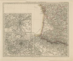
Antique Map of Southeastern France
Corsica – Stülpnagel Engraving, 1858
Highly detailed 19th-century map titled "Südöstliches Frankreich"(Southeastern France), engraved by Friedrich von Stülpnagel and published by Justus Perthes in Gotha in 1858. This map represents the final quadrant of Stülpnagel's four-part map of France and showcases the picturesque and historically rich regions along the Mediterranean coast, including Provence, Dauphiné, Languedoc, and the island of Corsica.
Prominent cities such as Marseille, Nice, Avignon, Nîmes, Grenoble, and Toulon are clearly labeled, along with countless towns, rivers, and mountain ranges. The map features detailed topographical shading to illustrate the dramatic relief of the French Alps and Massif Central, and outlines each département with delicate hand-coloring.
An inset in the lower center adds further detail:
– "Marseille und Umgebungen" – a detailed city and regional map showing Marseille and its surroundings, including coastal features and road connections.
The Mediterranean coastline is carefully engraved, showing the Golfe du Lion, Golfe de Gênes, and parts of the Ligurian coast of Italy. The inclusion of Corsica in the southeast corner adds a valuable geographic and political component to this map, reflecting France’s full territorial reach in the region.
Produced during the Second French Empire, this map is a valuable document of the administrative and physical landscape of the south of France before the transformation brought by 20th-century infrastructure and tourism. Its precision and artistry make it suitable for both historical study and refined interior display.
Condition report:
Very good condition. Minor age-related toning in margins. No tears or repairs. Original hand-coloring remains clean and vibrant. Inset clear and intact.
Framing tips:
Frame with a light wood or champagne-gold finish to complement the coastal tones. Use a pale cream mat or a light grey to enhance the engraving. A double mat with a narrow burgundy accent could reflect the outline colors and add refinement.
Technique: Copperplate engraving with original hand-coloring
Maker: F. von Stülpnagel, published by Justus Perthes, Gotha, 1858
- Dimensions:Height: 14.77 in (37.5 cm)Width: 17.88 in (45.4 cm)Depth: 0.01 in (0.2 mm)
- Materials and Techniques:Paper,Engraved
- Place of Origin:
- Period:
- Date of Manufacture:1858
- Condition:Very good condition. Minor age-related toning in margins. No tears or repairs. Original hand-coloring remains clean and vibrant. Inset clear and intact.
- Seller Location:Langweer, NL
- Reference Number:Seller: BG-05552-181stDibs: LU3054346116242
About the Seller
5.0
Recognized Seller
These prestigious sellers are industry leaders and represent the highest echelon for item quality and design.
Platinum Seller
Premium sellers with a 4.7+ rating and 24-hour response times
Established in 2009
1stDibs seller since 2017
2,792 sales on 1stDibs
Typical response time: <1 hour
- ShippingRetrieving quote...Shipping from: Langweer, Netherlands
- Return Policy
More From This Seller
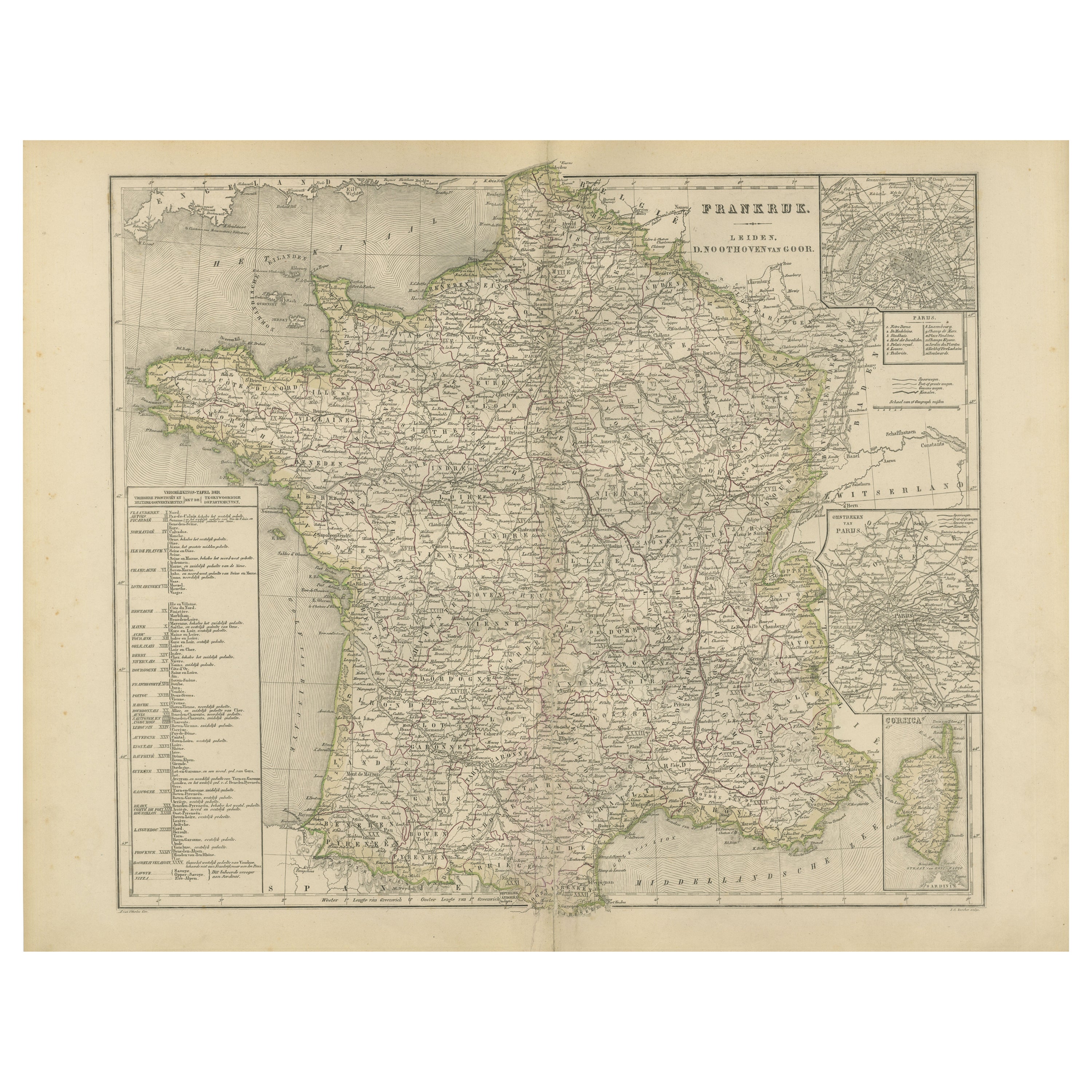
View AllMap of France with Corsica and Paris Inset – Nieuwe Hand-Atlas, 1876
Located in Langweer, NL
Title: Map of France with Corsica and Paris Inset – Nieuwe Hand-Atlas, 1876
Description:
This detailed 19th-century map, titled “Frankrijk,” was published in 1876 in the *Nieuwe Han...
Category
Antique 1870s Dutch Maps
Materials
Paper
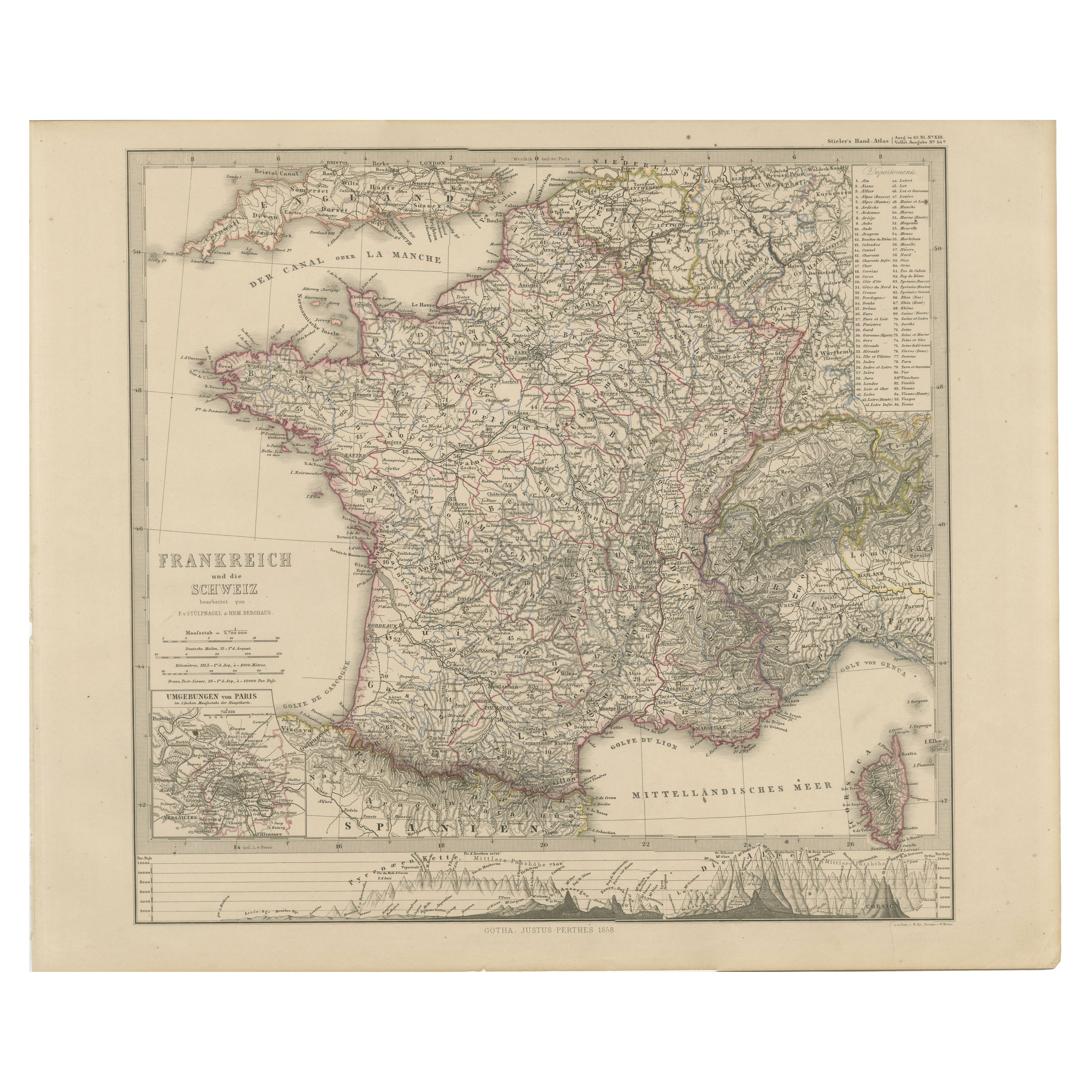
1856 France and Switzerland Map with Mountain Profiles
Located in Langweer, NL
1856 Map of France and Switzerland with Paris Inset by Stülpnagel
This finely detailed antique map of France and Switzerland was published in 1856 by the esteemed German cartographe...
Category
Antique Mid-19th Century German Maps
Materials
Paper
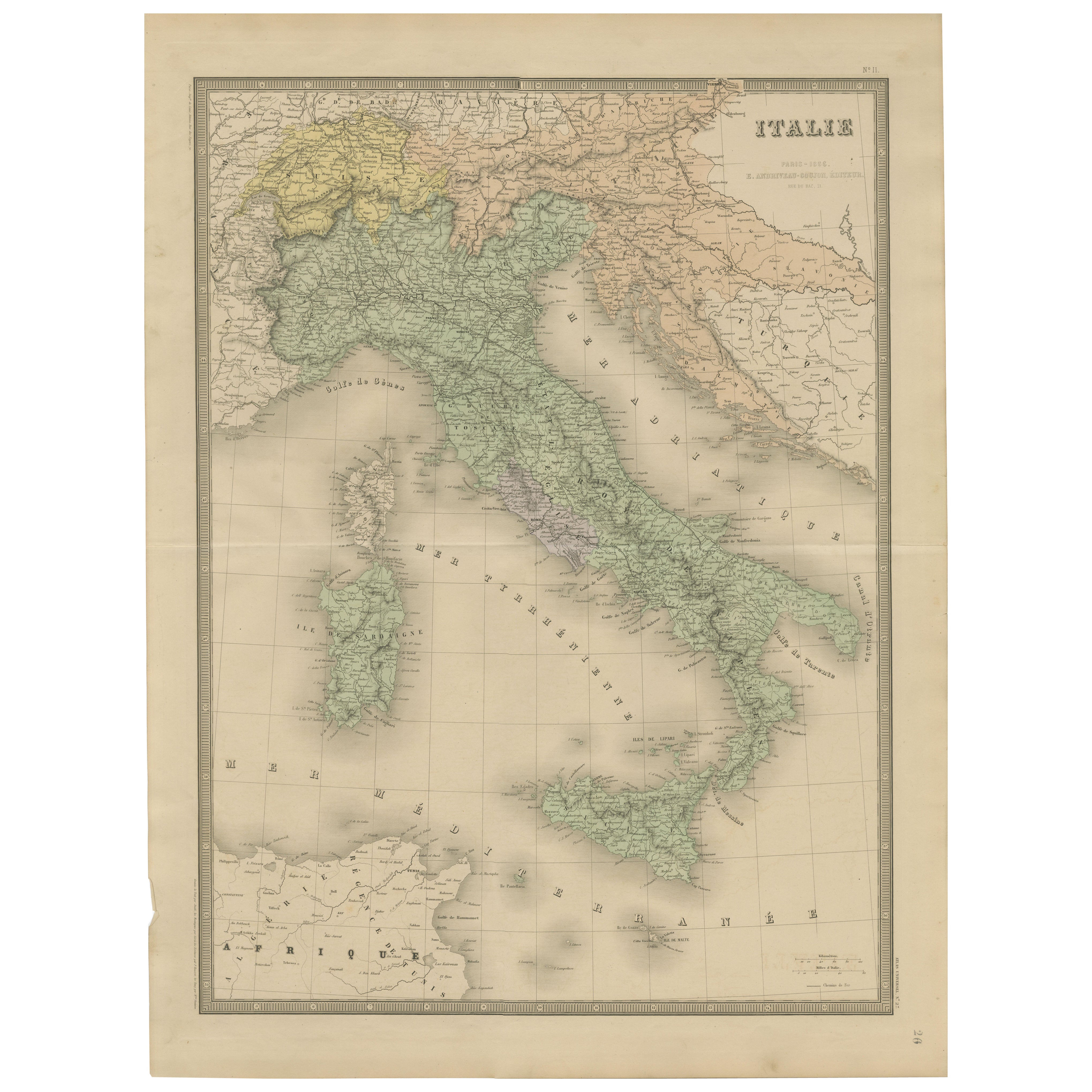
Antique Map of Italy – Pre-Unification Italy by Andriveau-Goujon, Paris 1861
Located in Langweer, NL
Antique Map of Italy – Pre-Unification Italy by Andriveau-Goujon, Paris 1861
This antique map of Italy, titled simply “Italie,” was published in Paris in 1861 by E. Andriveau-Goujon...
Category
Antique Mid-19th Century French Maps
Materials
Paper
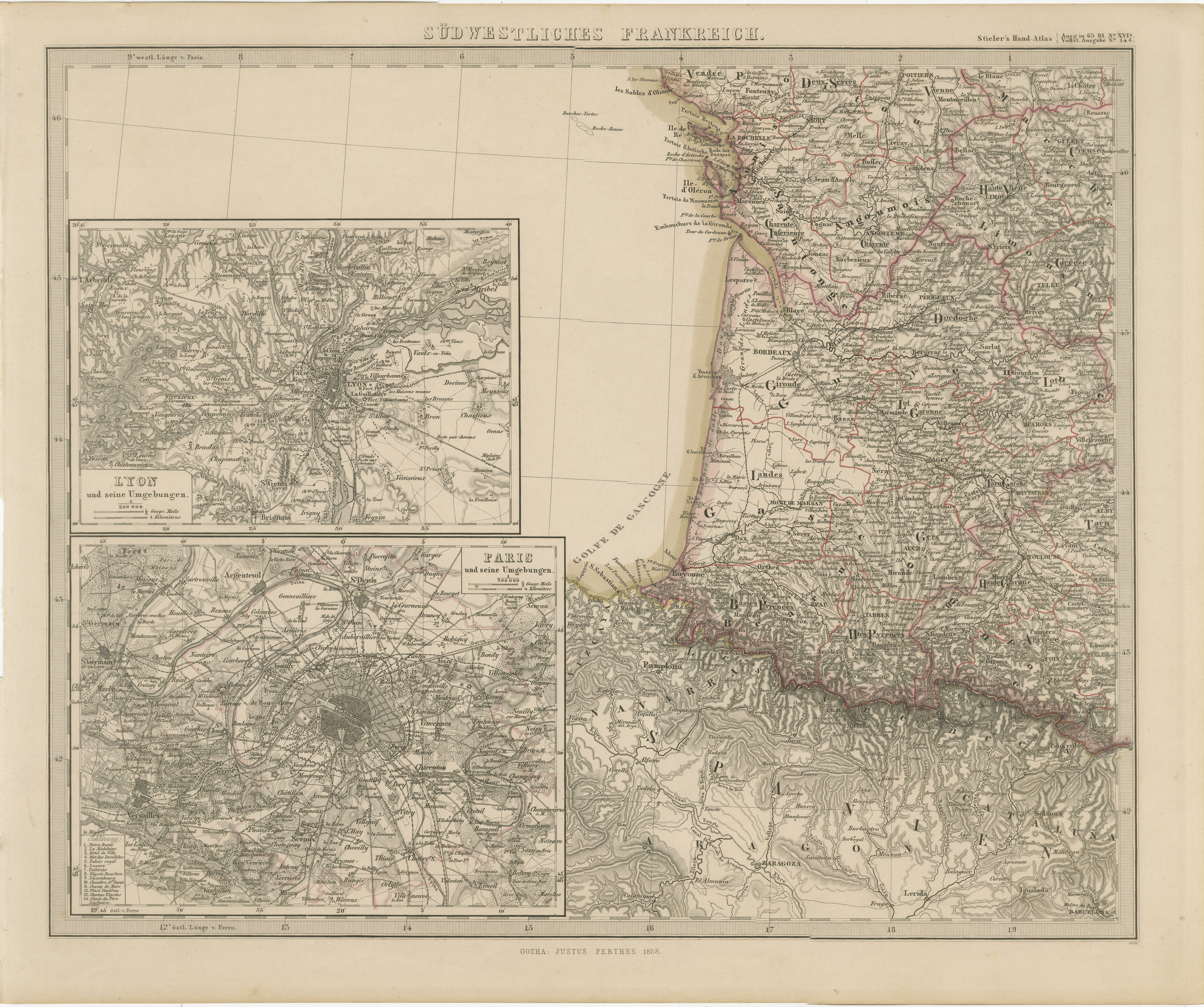
Antique Map of Southwestern France – With Insets of Paris
Lyon, 1858
Located in Langweer, NL
Antique Map of Southwestern France – With Insets of Paris & Lyon, 1858
Detailed copperplate map of "Südwestliches Frankreich" (Southwestern France), created by Friedrich von Stülpna...
Category
Antique Mid-19th Century German Maps
Materials
Paper
Antique Map of France, 1903, with Inset of Paris and Corsica
Located in Langweer, NL
Title: Antique Map of France, 1903, with Inset of Paris and Corsica
Description:
This antique map, titled "France," was engraved and published in 1903 by the renowned W. & A.K. John...
Category
Early 20th Century Maps
Materials
Paper

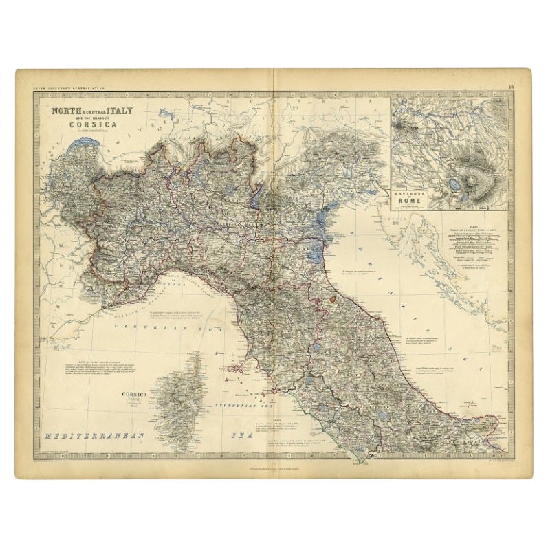
Antique Map of Italy and Corsica, c.1860
Located in Langweer, NL
Antique map titled 'North & Central Italy and the Island of Corsica'.
Old map of North and Central Italy, and the island of Corsica. With an inset map of the region of Rome. Orig...
Category
Antique 19th Century Maps
Materials
Paper
You May Also Like
Italy, Northern Part. Century Atlas antique vintage map
Located in Melbourne, Victoria
'The Century Atlas. Italy, Northern Part.'
Original antique map, 1903.
Central fold as issued. Map name and number printed on the reverse corners.
Sheet 29.5cm by 40cm.
Category
Early 20th Century Victorian More Prints
Materials
Lithograph

Italy, Central and Southern Part. Century Atlas antique map
Located in Melbourne, Victoria
'The Century Atlas. Italy, Central and Southern Part.'
Original antique map, 1903.
Inset maps of Sicily and Naples.
Central fold as issued. Map name an...
Category
Early 20th Century Victorian More Prints
Materials
Lithograph

Large Original Antique Map of Italy. John Dower, 1861
Located in St Annes, Lancashire
Great map of Italy
Lithograph engraving by John Dower
Original colour
Published, 1861
Unframed
Good condition / repair to top right corner seen in last image
Category
Antique 1860s English Victorian Maps
Materials
Paper

Large Original Antique Map of The South of Italy. John Dower, 1861
Located in St Annes, Lancashire
Great map of the South of Italy
Lithograph engraving by John Dower
Original colour
Published, 1861
Unframed
Good condition
Free shipping
Category
Antique 1860s English Victorian Maps
Materials
Paper

1849 Map of "Europaische Russland",
Meyer Map of European Russia
, Ric. R017
Located in Norton, MA
1849 Map of
"Europaische Russland"
( Meyer Map of European Russia)
Ric.r017
A lovely map of European Russia dating to 1849 by Joseph Meyer. It covers the European portions of...
Category
Antique 19th Century Unknown Maps
Materials
Paper

France, Northern Part. Century Atlas antique map
Located in Melbourne, Victoria
'The Century Atlas. France, Northern Part.'
Original antique map, 1903.
Inset maps of 'France in Provinces' and 'Paris and Vicinity'.
Central fold as issued. Map name and number pr...
Category
Early 20th Century Victorian More Prints
Materials
Lithograph

More Ways To Browse
French Second Empire
Beni Ourain Rugs
Glass Top Wood Base Coffee Tables
T Chair
Pair Of Danish Chairs
Veneer Dining Tables
1970 Italian Armchair
Furniture Uk
House Of Denmark Table And Chairs
Louis Marble Top Side Table
Antique Russian Rugs
Baker Furniture By
For Kids
Sterling Silver Flatware Set Service For 12
Tufted Bar
Pair Of French Antique Armchairs
1970s Brass Glass Coffee Table
Antique Column Base