Items Similar to 1858 Map of Southwestern Germany
Switzerland – Bavaria, Württemberg, Baden

Video Loading
Want more images or videos?
Request additional images or videos from the seller
1 of 11
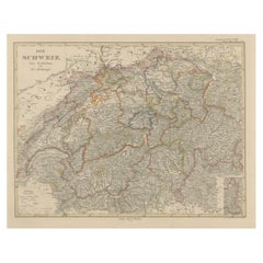
1858 Map of Southwestern Germany
Switzerland – Bavaria, Württemberg, Baden
$524.30
£390.53
€440
CA$722.01
A$785.88
CHF 416.41
MX$9,451.46
NOK 5,294.58
SEK 4,851.89
DKK 3,352.51
About the Item
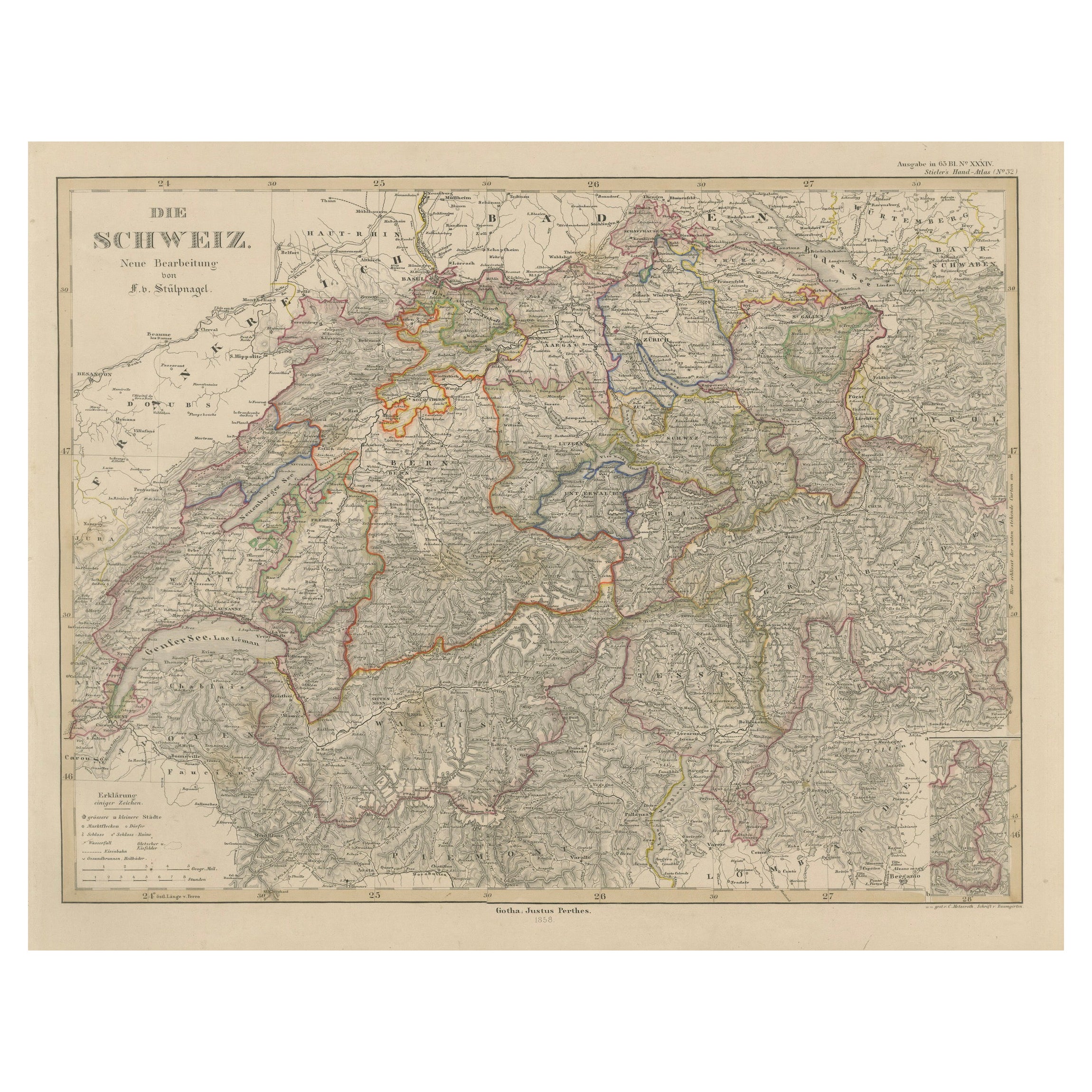
Antique Map of Southwestern Germany
Switzerland – Bavaria, Württemberg, Baden, 1858
Detailed antique map titled "Südwestliches Deutschland mit Bayern, Würtemberg, Baden, Hohenzollern und Schweiz", published by Justus Perthes in Gotha in 1858. This copperplate engraving presents a richly detailed view of Southwestern Germany and Switzerland during the mid-19th century, a time of growing national consciousness and evolving regional alliances prior to German unification.
The map encompasses the southern German states of Bavaria (Bayern), Württemberg, Baden, and Hohenzollern, extending southward into Switzerland and westward to the Rhine. A wealth of cities, roads, and rivers are labeled, including Munich (München), Stuttgart, Freiburg, Augsburg, and Zurich. Switzerland’s mountainous topography is carefully engraved, as is the Black Forest region of Baden.
Administrative boundaries are outlined in vivid hand-coloring, and a key at lower right lists abbreviations for Bavarian districts. The Alpine terrain is represented with shaded relief, conveying the geographical transition from southern Germany into the Swiss Alps and northern Tyrol.
This map is valuable not only for its political geography but also for its finely rendered depiction of terrain and infrastructure during a pivotal period in Central European history. Its detail and clarity make it a compelling item for collectors of maps focusing on German regional history or the early modern Swiss Confederation.
Condition report:
Very good condition. Minor toning in the outer margins. Hand-coloring remains vibrant and clear. No tears, foxing, or repairs noted. Please examine the image closely for additional detail.
Framing tips:
Pair this map with a natural wood or black frame and a soft ivory mat. A thin red or green accent line in the mat can reflect the political boundaries and enhance contrast. Suitable for historical or academic interiors, especially alongside other 19th-century Germanic or Alpine maps.
Technique: Copperplate engraving with original hand-coloring
Maker: Justus Perthes, Gotha, 1858
- Dimensions:Height: 14.77 in (37.5 cm)Width: 17.88 in (45.4 cm)Depth: 0.01 in (0.2 mm)
- Materials and Techniques:Paper,Engraved
- Place of Origin:
- Period:
- Date of Manufacture:1858
- Condition:Very good condition. Minor toning in the outer margins. Hand-coloring remains vibrant and clear. No tears, foxing, or repairs noted. Please examine the image closely for additional detail.
- Seller Location:Langweer, NL
- Reference Number:Seller: BG-05552-321stDibs: LU3054346118482
About the Seller
5.0
Recognized Seller
These prestigious sellers are industry leaders and represent the highest echelon for item quality and design.
Platinum Seller
Premium sellers with a 4.7+ rating and 24-hour response times
Established in 2009
1stDibs seller since 2017
2,824 sales on 1stDibs
Typical response time: 1 hour
- ShippingRetrieving quote...Shipping from: Langweer, Netherlands
- Return Policy
More From This Seller
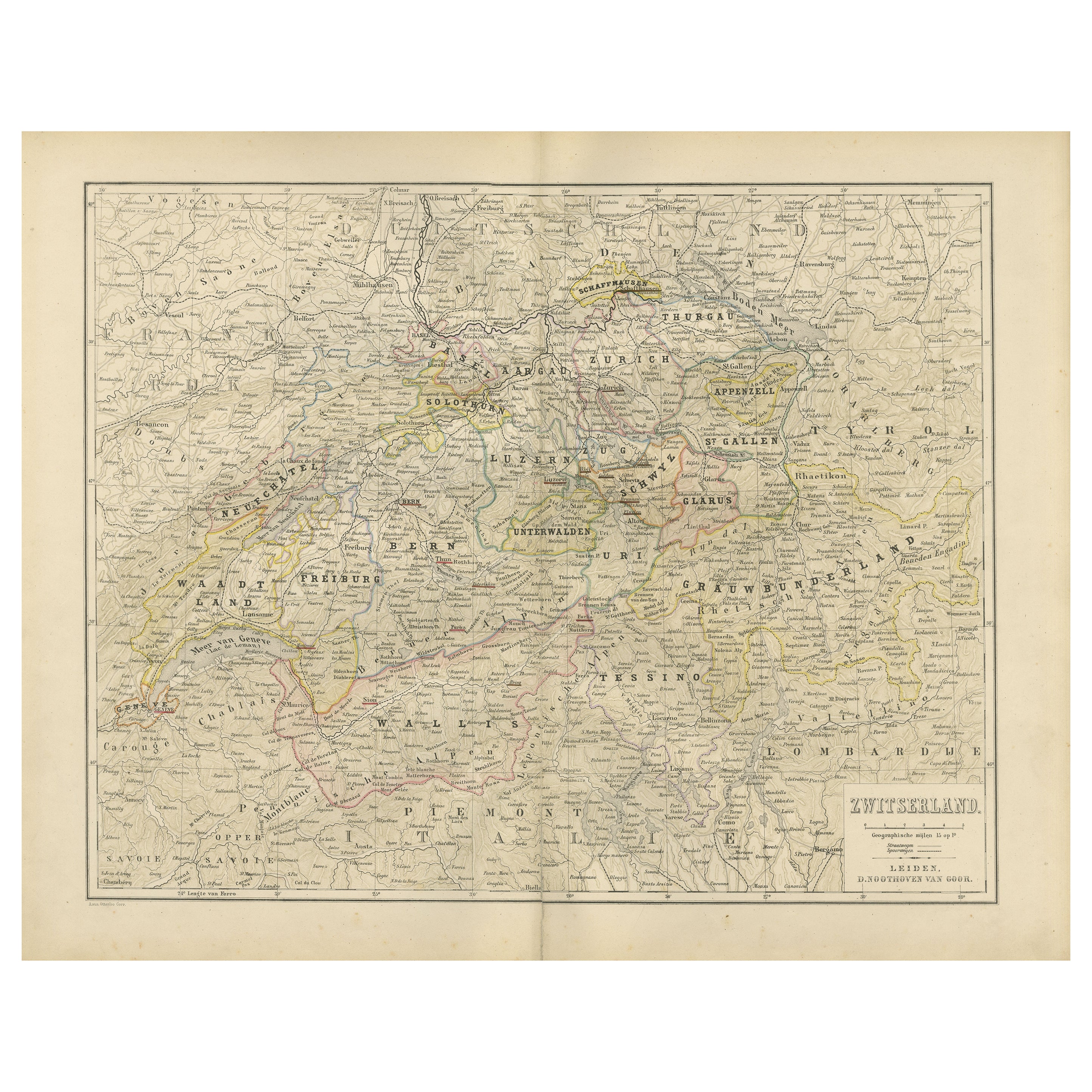
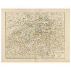
View AllMap of Switzerland with Cantonal Boundaries – Nieuwe Hand-Atlas, 1876
Located in Langweer, NL
Map of Switzerland with Cantonal Boundaries – Nieuwe Hand-Atlas, 1876
This finely detailed 19th-century map, titled “Zwitserland,” was published in 1876 in the *Nieuwe Hand-Atlas de...
Category
Antique 1870s Dutch Maps
Materials
Paper
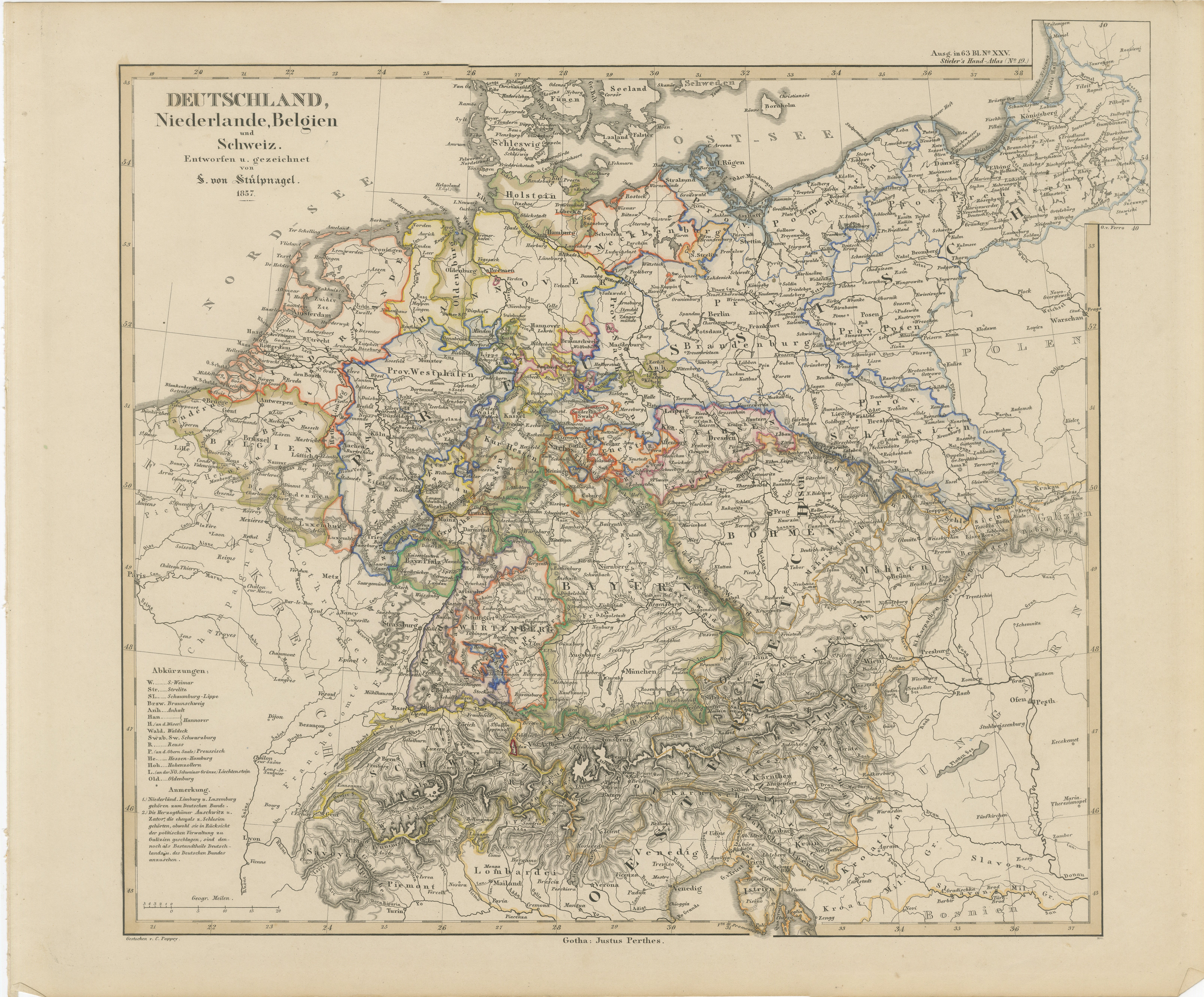
Antique Map of Germany, Netherlands, Belgium
Switzerland – Stülpnagel, 1857
Located in Langweer, NL
Antique Map of Germany, Netherlands, Belgium & Switzerland – Stülpnagel, 1857
Fine mid-19th century map of Central Europe titled "Deutschland, Niederlande, Belgien, Schweiz", drawn ...
Category
Antique Mid-19th Century German Maps
Materials
Paper

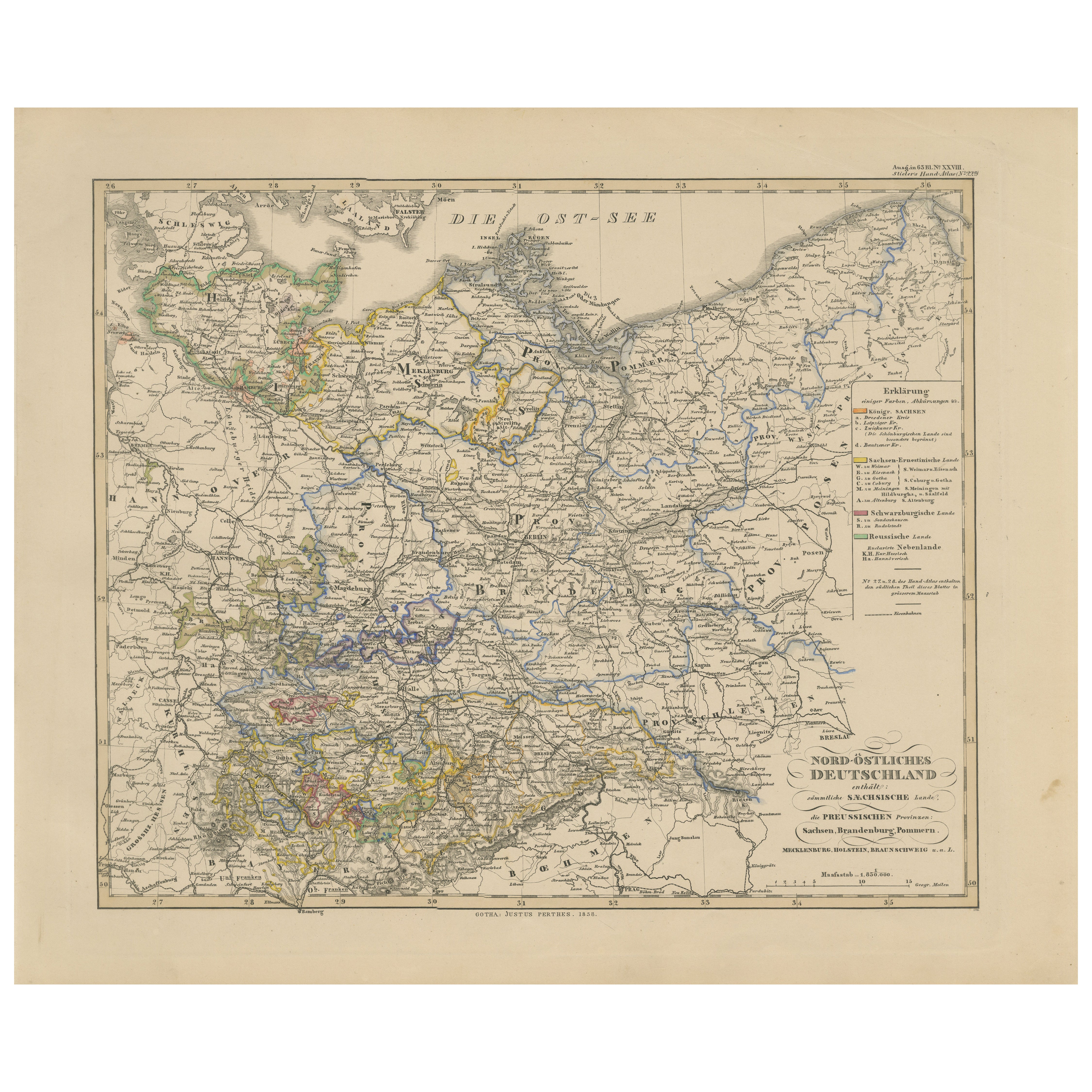
Antique Map of Northeastern Germany – Saxon
Prussian States, 1858
Located in Langweer, NL
Antique Map of Northeastern Germany – Saxon & Prussian States, 1858
Detailed and finely engraved map titled "Nord-Östliches Deutschland enthaltend die Sächsischen Länder und die Pre...
Category
Antique Mid-19th Century German Maps
Materials
Paper
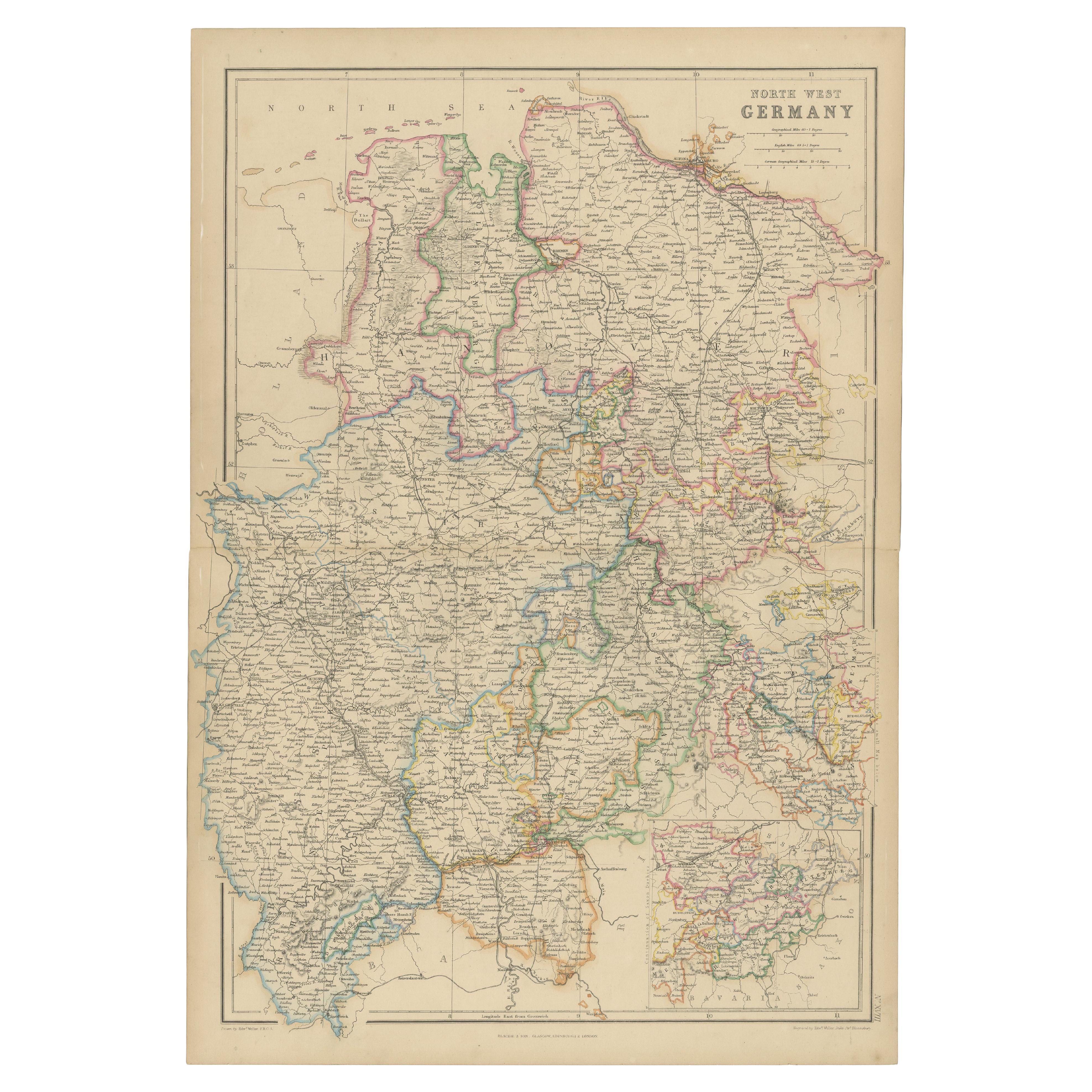
1859 Detailed Map of North West Germany with Bavaria Inset - Blackie
s Atlas
Located in Langweer, NL
The "Antique Map of North West Germany" with an inset map of Bavaria is a distinguished piece from 'The Imperial Atlas of Modern Geography', published i...
Category
Antique Mid-19th Century Maps
Materials
Paper
$208 Sale Price
30% Off
Antique Map of Switzerland by J. Tallis, circa 1851
Located in Langweer, NL
A decorative and detailed mid-19th century map of Switzerland which was drawn and engraved by J. Rapkin (vignettes by A. H. Wray & J. B. Allen) and published in John Tallis's Illustr...
Category
Antique Mid-19th Century British Maps
Materials
Paper

$262 Sale Price
20% Off
1856 Engraved Map of Switzerland with Cantonal Borders by Stülpnagel
Located in Langweer, NL
1856 Engraved Map of Switzerland with Cantonal Borders by Stülpnagel
This finely detailed antique map of Switzerland, titled "Die Schweiz," was published in 1856 by the renowned Ger...
Category
Antique Mid-19th Century German Maps
Materials
Paper
You May Also Like
Austria-Hungary, Western Part. Century Atlas antique vintage map
Located in Melbourne, Victoria
'The Century Atlas. Austria-Hungary, Western Part'
Original antique map, 1903.
Central fold as issued. Map name and number printed on the reverse corners.
Sheet 40cm by 29.5cm.
Category
Early 20th Century Victorian More Prints
Materials
Lithograph

German Empire, Southwestern Part. Century Atlas antique vintage map
Located in Melbourne, Victoria
'The Century Atlas. German Empire, Southwestern Part'
Original antique map, 1903.
Central fold as issued. Map name and number printed on the reverse co...
Category
Early 20th Century Victorian More Prints
Materials
Lithograph

1839 Map of Karte Des "Russischen Reiches in Europa Und Asien" Ric.R0013
Located in Norton, MA
1839 map of Karte Des
"Russischen Reiches in Europa and Asien"
Ric.r013
Map of the European and Asian parts of Russian Empire. Karte der Russischen Reiches in Europa und Asien...
Category
Antique 19th Century Unknown Maps
Materials
Paper

German Empire, Northern Part. Century Atlas antique vintage map
Located in Melbourne, Victoria
'The Century Atlas. German Empire, Northern Part.'
Original antique map, 1903.
Central fold as issued. Map name and number printed on the reverse corne...
Category
Early 20th Century Victorian More Prints
Materials
Lithograph

Original Antique English County Map, Nottinghamshire, J
C Walker, 1851
Located in St Annes, Lancashire
Great map of Nottinghamshire
Original colour
By J & C Walker
Published by Longman, Rees, Orme, Brown & Co. 1851
Unframed.
Category
Antique 1850s English Other Maps
Materials
Paper

1853 Map of "Russia in Europe Including Poland" Ric.r016
Located in Norton, MA
Description
Russia in Europe incl. Poland by J Wyld c.1853
Hand coloured steel engraving
Dimension: Paper: 25 cm W x 33 cm H ; Sight: 22 cm W x 28 cm H
Condition: Good ...
Category
Antique 19th Century Unknown Maps
Materials
Paper

More Ways To Browse
Bavaria Antique
German Wurttemberg
Bavarian Antique
Used Southwestern Furniture
Southwestern Antiques
Beni Ourain Rugs
Glass Top Wood Base Coffee Tables
T Chair
Pair Of Danish Chairs
Veneer Dining Tables
1970 Italian Armchair
Furniture Uk
House Of Denmark Table And Chairs
Louis Marble Top Side Table
Antique Russian Rugs
Baker Furniture By
For Kids
Sterling Silver Flatware Set Service For 12