Items Similar to 1862 Johnson
s Map of the Vicinity of Richmond
Peninsular Campaign, Virginia

Want more images or videos?
Request additional images or videos from the seller
1 of 10
1862 Johnson
s Map of the Vicinity of Richmond
Peninsular Campaign, Virginia
$464.72
£346.15
€390
CA$639.96
A$696.58
CHF 369.09
MX$8,377.43
NOK 4,692.92
SEK 4,300.54
DKK 2,971.54
About the Item
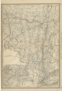
Title: 1862 Johnson's Map of the Vicinity of Richmond
Peninsular Campaign, Virginia
Description: This 1862 map titled "Johnson's Map of the Vicinity of Richmond and Peninsular Campaign, Virginia" was published by Johnson and Ward. It depicts the areas around Richmond, Virginia, and the routes involved in the Peninsular Campaign of the American Civil War. This detailed map shows county divisions, rivers, roads, and railroads, making it an invaluable resource for understanding the strategic movements of both Confederate and Union forces during the campaign.
The map highlights key locations like Williamsburg, Yorktown, and Richmond, and includes notable battle sites, military encampments, and points of strategic interest. The pink and green coloration helps distinguish different counties, making the geographical information easier to interpret. Its historical importance is underscored by its compilation from official maps by the War Department, offering a near-contemporary view of military operations during one of the critical campaigns of the Civil War.
Condition:
The map is in good condition, with slight yellowing around the edges typical of documents from the 19th century. The hand-coloring remains vivid, which helps differentiate the counties and areas of importance. A central fold is present, indicating its inclusion in an atlas, but it is well-preserved and does not detract from the clarity of the map. The overall aesthetic, has been maintained without any major tears or visible damage, making it an appealing piece for collectors or those interested in Civil War history.
- Dimensions:Height: 18.12 in (46 cm)Width: 27.96 in (71 cm)Depth: 0.01 in (0.2 mm)
- Materials and Techniques:
- Place of Origin:
- Period:
- Date of Manufacture:1862
- Condition:Condition: Good condition, with light yellowing along the edges, consistent with its age. The central fold, from its original inclusion in an atlas, is evident but well-maintained. The colors are bright.
- Seller Location:Langweer, NL
- Reference Number:Seller: BG-13952-91stDibs: LU3054342436602
About the Seller
5.0
Recognized Seller
These prestigious sellers are industry leaders and represent the highest echelon for item quality and design.
Platinum Seller
Premium sellers with a 4.7+ rating and 24-hour response times
Established in 2009
1stDibs seller since 2017
2,824 sales on 1stDibs
Typical response time: 1 hour
- ShippingRetrieving quote...Shipping from: Langweer, Netherlands
- Return Policy
More From This Seller
View All1864 Johnson
s Map of Virginia, Delaware, and Maryland with Fort Monroe Inset
Located in Langweer, NL
Title: 1864 Johnson's Map of Virginia, Delaware, and Maryland with Fort Monroe Inset
Description: This 1864 map titled "Johnson's Virginia, Delaware, and ...
Category
Antique 1860s Maps
Materials
Paper
$285 Sale Price
20% Off
Antique Virginia Map c.1888 – Railroads, Towns
The Old Dominion
Located in Langweer, NL
Antique Map of Virginia – Rand McNally, circa 1888
This antique map of Virginia was published by Rand, McNally & Co. around 1888. Drawn from one of their influential late 19th-centu...
Category
Antique Late 19th Century American Maps
Materials
Paper
Antique Map of The Dutch Smallingerland Township, 1861
Located in Langweer, NL
Antique map titled 'Gemeente Smallingerland'. Old map depicting the Smallingerland township including cities and villages like Eernewoude, Oudega, Boornbergum, Opeinde and Drachten. ...
Category
Antique 19th Century Maps
Materials
Paper
Antique Map of Southeastern New York by Rand McNally, Lithograph, 1888
Located in Langweer, NL
Antique Map of Southeastern New York – Rand McNally, circa 1888
This antique map of southeastern New York was published by Rand, McNally
Co. around 1888. It offers a detailed ...
Category
Antique Late 19th Century American Maps
Materials
Paper
Antique Map of the Menaldumadeel Township by Behrns, 1861
Located in Langweer, NL
Antique map titled 'Gemeente Menaldumadeel'. Old map depicting the Menaldumadeel township including cities and villages like Berlikum, Wier, Menaldum, Dronrijp, Marsum, Engelum, Dein...
Category
Antique 19th Century Maps
Materials
Paper
Antique Map of the Kollumerland Township by Behrns, 1861
Located in Langweer, NL
Antique map titled 'Gemeente Kollumerland en Nieuw Kruisland'. Old map depicting the Kollumerland township including cities and villages like Westergeest, Kollum, Kollumerzwaag and B...
Category
Antique 19th Century Maps
Materials
Paper
You May Also Like
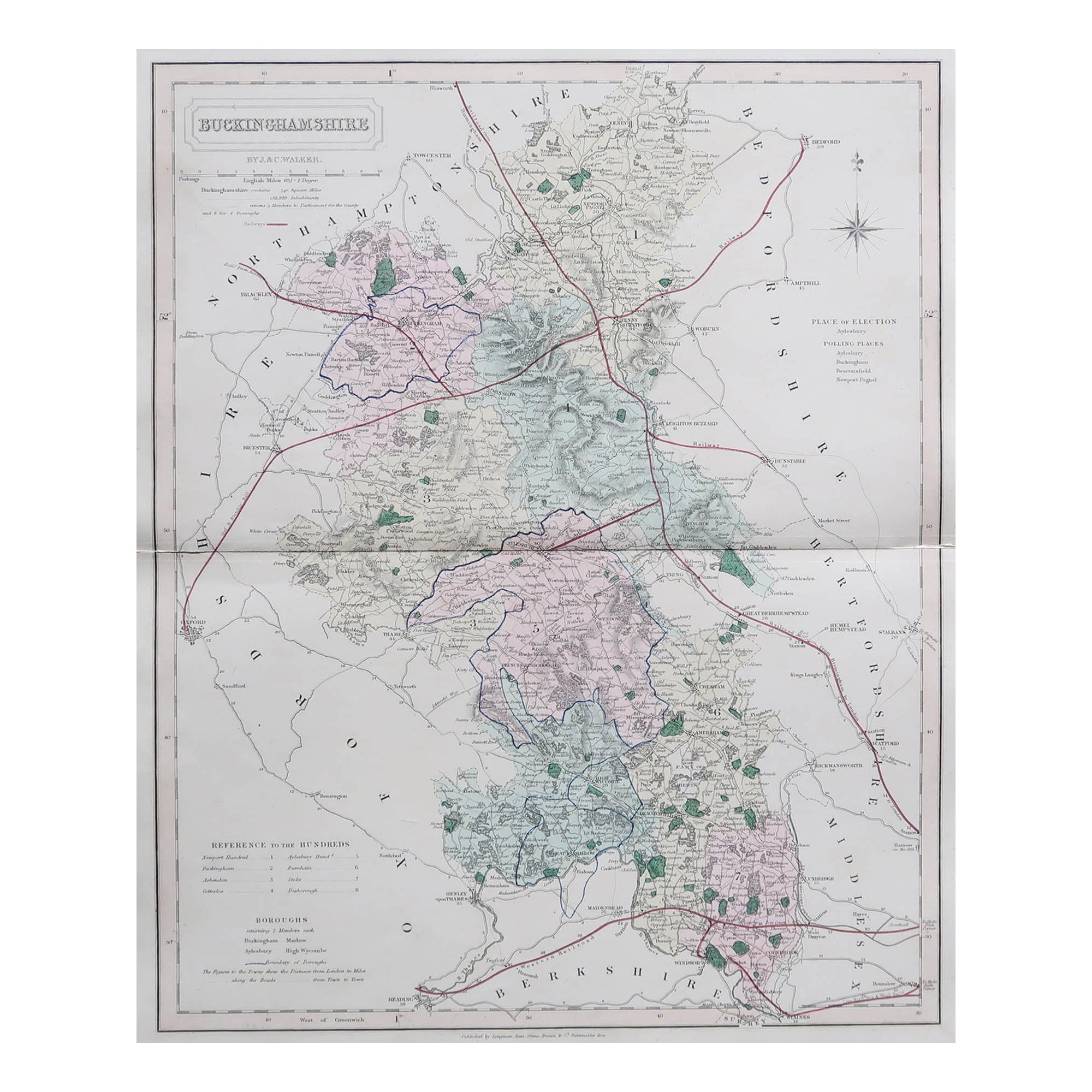
Original Antique English County Map, Buckinghamshire, J
C Walker, 1851
Located in St Annes, Lancashire
Great map of Buckinghamshire
Original colour
By J & C Walker
Published by Longman, Rees, Orme, Brown & Co. 1851
Unframed.
Category
Antique 1850s English Other Maps
Materials
Paper

Vicinity of London, England, United Kingdom. Century Atlas antique map
Located in Melbourne, Victoria
'The Century Atlas. Vicinity of London, England, United Kingdom.'
Original antique map, 1903.
Central fold as issued. Map name and number printed on the reverse corners.
Sheet 29.5...
Category
Early 20th Century Victorian More Prints
Materials
Lithograph

Original Antique English County Map - Monmouthshire. J
C Walker. 1851
Located in St Annes, Lancashire
Great map of Monmouthshire
Original colour
By J & C Walker
Published by Longman, Rees, Orme, Brown & Co. 1851
Unframed.
Category
Antique 1850s English Other Maps
Materials
Paper

Original Antique English County Map, Kent. J
C Walker, 1851
Located in St Annes, Lancashire
Great map of Kent
Original colour
By J & C Walker
Published by Longman, Rees, Orme, Brown & Co. 1851
Unframed.
Category
Antique 1850s English Other Maps
Materials
Paper

Original Antique English County Map, Derbyshire, J
C Walker, 1851
Located in St Annes, Lancashire
Great map of Derbyshire
Original colour
By J & C Walker
Published by Longman, Rees, Orme, Brown & Co. 1851
Unframed.
Category
Antique 1850s English Other Maps
Materials
Paper

Original Antique Map of The United States of America by Dower, circa 1835
Located in St Annes, Lancashire
Nice map of the USA
Drawn and engraved by J.Dower
Published by Orr & Smith. C.1835
Unframed.
Free shipping
Category
Antique 1830s English Maps
Materials
Paper

More Ways To Browse
Richmond Virginia
Antique Furniture Richmond
Black Scandinavian Modern Dining Chairs
Gold Modern Coffee Table
Round Glass Coffee Tables
18th Century Wood Side Tables
Antique Hand Carved Dining Room Sets
Mid Century Modern Pitcher
Vintage Italian Leather Dining Chair
Vintage Movie Posters
Blue Green Wool And Silk Rug
Brown Sheepskin Chair
Vintage Brass Bar Carts
Antique Botanical Prints
Green Persian Rug
17th Century Blue And White
50 X 50 Coffee Table
Antique Wood Panel Painted