Items Similar to 1864 Johnson
s Map of New York State with City Insets

Want more images or videos?
Request additional images or videos from the seller
1 of 6
1864 Johnson
s Map of New York State with City Insets
$268.05
$335.0620% Off
£200.20
£250.2520% Off
€224
€28020% Off
CA$369.29
CA$461.6120% Off
A$402.46
A$503.0720% Off
CHF 213.12
CHF 266.4020% Off
MX$4,833.92
MX$6,042.4020% Off
NOK 2,698.12
NOK 3,372.6520% Off
SEK 2,480.65
SEK 3,100.8220% Off
DKK 1,706.49
DKK 2,133.1220% Off
About the Item
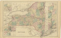
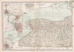
Title: 1864 Johnson's Map of New York State with City Insets
Description: This 1864 map, titled "Johnson's New York," was published by Johnson and Ward and features a detailed depiction of New York State during the mid-19th century. The map is intricately colored to distinguish between counties, with bold boundary lines and clear labels for towns and major geographic features. Notably, it includes inset maps of key cities, such as Albany, Troy, Buffalo, Rochester, Syracuse, and Oswego, providing a glimpse into their layouts during this era.
This map is interesting because it not only represents the state's counties and infrastructure, such as railroads and roads, but also offers detailed views of several major urban areas. The insets are particularly valuable for understanding the development of these cities at a time when the state was rapidly growing in population and industry.
Condition:
The map is in good condition, with minor yellowing along the edges that is typical for its age. There is a central fold that indicates it was originally part of an atlas, and the elaborate decorative border remains intact. The colors are still vivid, enhancing the clarity of both the county boundaries and city insets, contributing to the overall visual appeal of the map.
- Dimensions:Height: 17.13 in (43.5 cm)Width: 26.78 in (68 cm)Depth: 0 in (0.02 mm)
- Materials and Techniques:
- Period:
- Date of Manufacture:1864
- Condition:Good condition, considering age, with some yellowing that is typical of maps from this period. Some soiling and small tears along the edges, due to handling. Study the images carefully.
- Seller Location:Langweer, NL
- Reference Number:Seller: BG-13952-31stDibs: LU3054342419372
About the Seller
5.0
Recognized Seller
These prestigious sellers are industry leaders and represent the highest echelon for item quality and design.
Platinum Seller
Premium sellers with a 4.7+ rating and 24-hour response times
Established in 2009
1stDibs seller since 2017
2,788 sales on 1stDibs
Typical response time: <1 hour
- ShippingRetrieving quote...Shipping from: Langweer, Netherlands
- Return Policy
More From This Seller
View All1862 Johnson
s Map of New York State by Johnson
Browning
Located in Langweer, NL
Title: 1862 Johnson's Map of New York State by Johnson & Browning
Description:This is an 1862 map of New York State, titled "Johnson's New York," created by Johnson & Browning. The ...
Category
Antique 1860s Maps
Materials
Paper

$268 Sale Price
20% Off
1876 Antique Map of New York State with Niagara and Hudson River Insets
Located in Langweer, NL
Title: Detailed Map of New York State - 1876 by Samuel Augustus Mitchell Jr.
Description: This is a hand-colored map of the state of New York from 1876, created by Samuel Augustus ...
Category
Antique 1870s Maps
Materials
Paper
$210 Sale Price
20% Off
Antique Map of New York by Johnson
1872
Located in Langweer, NL
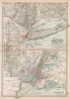
Antique map titled 'Johnson's New York'. Original map showing New York, with an inset map of Long Island. This map originates from 'Johnson's New Il...
Category
Antique Late 19th Century Maps
Materials
Paper

$239 Sale Price
20% Off
Large Antique Map of New York State with Inset Maps
Located in Langweer, NL
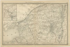
Antique map titled 'Johnson's New York' Large map of New York State. With insets of Albany, Oswego, Buffalo, Rochester, Syracuse, Troy and NYC. Published by Johnson and Browning, 186...
Category
Antique Mid-19th Century Maps
Materials
Paper

$469 Sale Price
20% Off
New York State Antique Map c.1888 – The Empire State, Railroads
Counties
Located in Langweer, NL
Antique Map of New York State – Rand McNally, circa 1888
This antique map of New York State was published by Rand, McNally & Co. around 1888. Unlike the sectional plates, this gener...
Category
Antique Late 19th Century American Maps
Materials
Paper

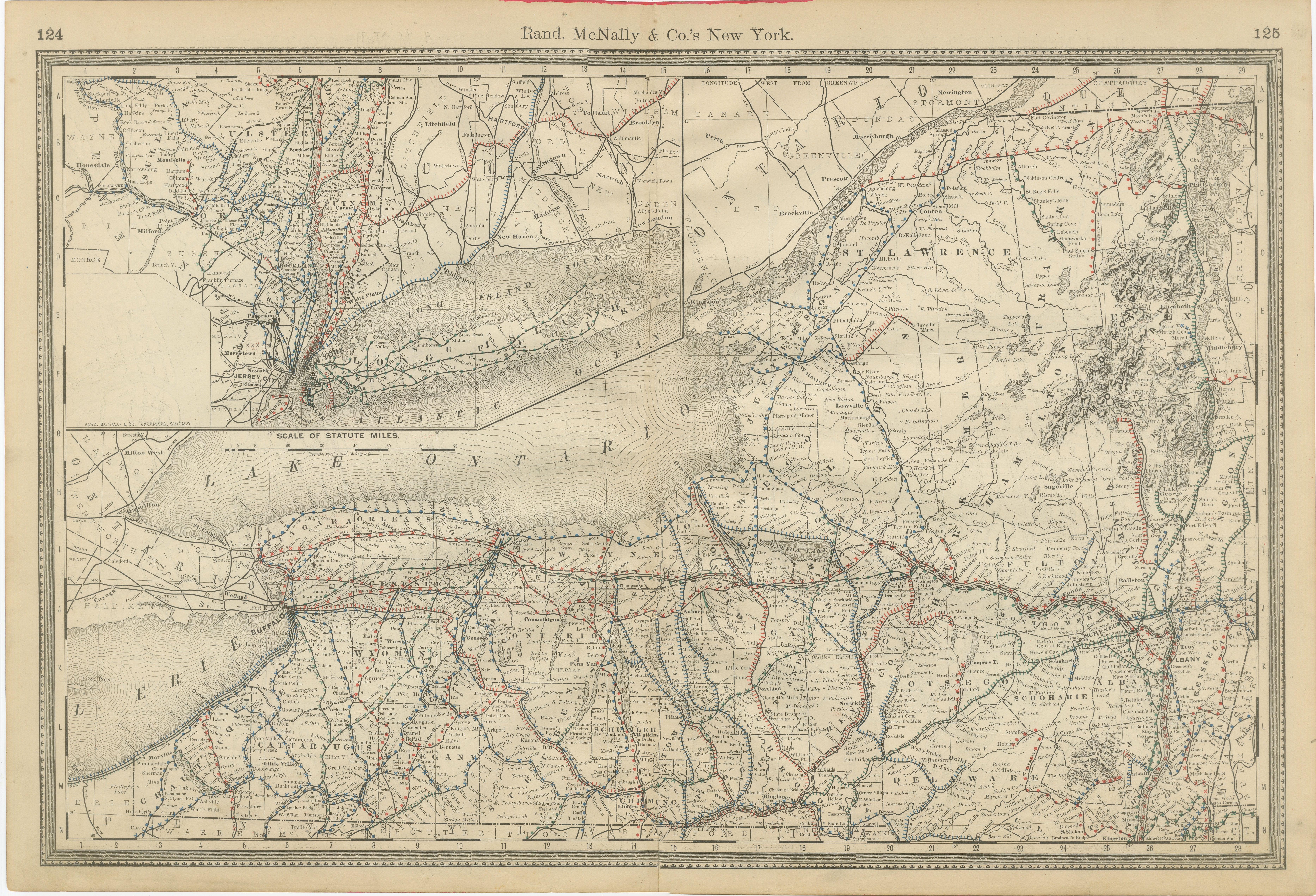
Antique Map of Northern New York – Rand McNally, circa 1888
Located in Langweer, NL
Antique Map of Northern New York – Rand McNally, circa 1888
This antique map of northern New York was published by Rand, McNally & Co. around 1888. Taken from one of their late 19th...
Category
Antique Late 19th Century American Maps
Materials
Paper
You May Also Like
1858 Colton
s Map of New York, Ric.B011
Located in Norton, MA
An 1858 Colton's map of New York
Ric.b011
Colton’s New York, 1858 - A large original color engraved and very detailed map of the state of New York,...
Category
Antique 19th Century Unknown Maps
Materials
Paper

Original Antique Map of the American State of New York ( Western Part ) 1903
Located in St Annes, Lancashire
Antique map of New York ( Western Part )
Published By A & C Black. 1903
Original colour
Good condition
Unframed.
Free shipping
Category
Antique Early 1900s English Maps
Materials
Paper

Original Antique Map of the American State of New York ( Northern Part ) 1903
Located in St Annes, Lancashire
Antique map of New York ( Northern Part )
Published By A & C Black. 1903
Original colour
Good condition
Unframed.
Free shipping
Category
Antique Early 1900s English Maps
Materials
Paper

New York. Southern Part. USA. Century Atlas state antique vintage map
Located in Melbourne, Victoria
'The Century Atlas. New York. Southern Part.'
Original antique map, 1903.
Inset maps of 'New York City and Vicinity' and 'The Hudson'.
Central fold as issued. Map name and number p...
Category
Early 20th Century Victorian More Prints
Materials
Lithograph
New York, Western Part. USA. Century Atlas state antique vintage map
Located in Melbourne, Victoria
'The Century Atlas. New York, Western Part'
Original antique map, 1903.
Central fold as issued. Map name and number printed on the reverse corners.
Sheet 29.5cm by 40cm.
Category
Early 20th Century Victorian More Prints
Materials
Lithograph
Original Antique Map of the American State of New York ( Southern Part ) 1903
Located in St Annes, Lancashire
Antique map of New York ( Southern Part )
Published By A & C Black. 1903
Original colour
Good condition
Unframed.
Free shipping
Category
Antique Early 1900s English Maps
Materials
Paper

More Ways To Browse
Black Scandinavian Modern Dining Chairs
Gold Modern Coffee Table
Round Glass Coffee Tables
18th Century Wood Side Tables
Antique Hand Carved Dining Room Sets
Mid Century Modern Pitcher
Vintage Italian Leather Dining Chair
Vintage Movie Posters
Blue Green Wool And Silk Rug
Brown Sheepskin Chair
Vintage Brass Bar Carts
Antique Botanical Prints
Green Persian Rug
17th Century Blue And White
50 X 50 Coffee Table
Antique Wood Panel Painted
Milo Baughman 1970
Spanish Baroque Furniture