Want more images or videos?
Request additional images or videos from the seller
1 of 8
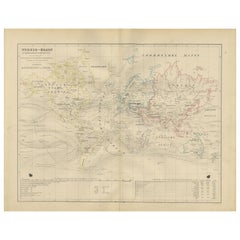
1864 Johnson
s Map of the World on Mercator
s Projection, Ric.B009
Price:$300
$325List Price
About the Item
- Dimensions:Height: 16.54 in (42 cm)Width: 25.01 in (63.5 cm)Depth: 0.4 in (1 cm)
- Materials and Techniques:
- Place of Origin:
- Period:
- Date of Manufacture:1864
- Condition:
- Seller Location:Norton, MA
- Reference Number:1stDibs: LU5848230077062
About the Seller
5.0
Platinum Seller
Premium sellers with a 4.7+ rating and 24-hour response times
Established in 2000
1stDibs seller since 2021
135 sales on 1stDibs
Typical response time: 1 hour
Authenticity Guarantee
In the unlikely event there’s an issue with an item’s authenticity, contact us within 1 year for a full refund. DetailsMoney-Back Guarantee
If your item is not as described, is damaged in transit, or does not arrive, contact us within 7 days for a full refund. Details24-Hour Cancellation
You have a 24-hour grace period in which to reconsider your purchase, with no questions asked.Vetted Professional Sellers
Our world-class sellers must adhere to strict standards for service and quality, maintaining the integrity of our listings.Price-Match Guarantee
If you find that a seller listed the same item for a lower price elsewhere, we’ll match it.Trusted Global Delivery
Our best-in-class carrier network provides specialized shipping options worldwide, including custom delivery.You May Also Like
Antique Map of the World on Mercator
s Projection, 1788
Located in Langweer, NL
Antique map titled 'Kaart van de Geheele Wereld (..)'. Uncommon small world map on Mercator's projection. Nice detail of the islands throughout the wor...
Category
Antique Late 18th Century Maps
Materials
Paper

$710 Sale Price
20% Off
H 8.08 in W 12.8 in D 0.02 in
World Map in Mercator’s Projection – Nieuwe Hand-Atlas, Leiden 1876
Located in Langweer, NL
World Map in Mercator’s Projection – Nieuwe Hand-Atlas, Leiden 1876
This 19th-century Dutch world map, titled “Wereld-Kaart in Mercator’s Projectie,” was published in 1876 in the Ni...
Category
Antique 1870s Dutch Maps
Materials
Paper
$272
H 17.33 in W 21.66 in D 0.01 in
Antique World Map on Mercator
s Projection, Ocean Currents and Trade Routes 1903
Located in Langweer, NL
Title: Antique World Map on Mercator's Projection, 1903, Showing Ocean Currents and Trade Routes
Description:
This antique map, titled "Chart of the World on Mercator's Projection,"...
Category
Early 20th Century Maps
Materials
Paper
$331
H 14.49 in W 18.9 in D 0.01 in
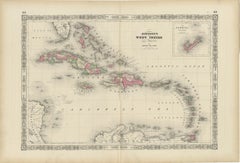
1864 Johnson
s Map of the West Indies and Bermuda
Located in Langweer, NL
Title: 1864 Johnson's Map of the West Indies and Bermuda
Description: This is an 1864 map titled "Johnson's West Indies," published by Johnson and Ward. The map provides a detailed ...
Category
Antique 1860s Maps
Materials
Paper
Antique Map of the World on Mercator Projection by Anson, 1749
Located in Langweer, NL
Antique map titled 'Nieuwe Wereld Kaart waar in de Reizen van den Hr. Anson rondsom de Wereld'. Original antique map of the world on Mercator'...
Category
Antique 18th Century Maps
Materials
Paper

$278 Sale Price
51% Off
H 10.63 in W 16.74 in D 0 in
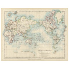
Colorful Detailed Antique Map of The World on Mercators Projection, 1882
Located in Langweer, NL
The 'World of Mercator's Projection' is a map with a stunning portrayal of global geography and maritime navigation from an era steeped in exploration and discovery. With meticulous detail and precision, this map showcases the world's continents on Mercator's famous projection, capturing the essence of a bygone era's cartographic expertise.
Illustrating the courses of chief ocean currents and key navigation tracks between major ports, this map doesn't just depict landmasses but also reveals the vital maritime routes that shaped global trade and exploration. Each line and curve represents the pathways of ancient voyages and modern seafaring, connecting distant shores and continents.
Crafted with the precision characteristic of Mercator's projection, this map offers a unique perspective on how sailors and explorers navigated the world's vast oceans. It stands as a testament to the artistry and scientific ingenuity of cartographers of that time, showcasing their commitment to accurate representation amid the challenges of mapping a spherical world on a flat surface.
This map isn't just a historical document; it's a captivating piece of cartographic art...
Category
Antique 1880s Maps
Materials
Paper
$236 Sale Price
20% Off
H 14.97 in W 22.45 in D 0 in
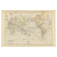
Antique Map of the World, Mercator Projection, by Wyld,
1845
Located in Langweer, NL
Antique map titled 'The World'. Original antique world map, on Mercator's projection. This map originates from 'An Atlas of the World, Compr...
Category
Antique Mid-19th Century Maps
Materials
Paper

$331 Sale Price
20% Off
H 10.24 in W 14.18 in D 0.02 in
Antique Mercator Projection World Map by Petri, c.1873
Located in Langweer, NL
Antique world map titled 'Wereldkaart naar Mercator's Projectie'. Old map of the world. This map originates from 'School-Atlas van alle Deelen der Aarde'.
Artists and engravers: ...
Category
Antique 19th Century Maps
Materials
Paper

Johnson’s Australia Map, USA Published c.1864 – Decorative Hand-Colored Map
Located in Langweer, NL
Johnson’s Australia Map, USA Published c.1864 – Decorative Hand-Colored Map
This is a finely engraved and hand-colored map titled Johnson’s Australia published by Johnson and Ward i...
Category
Antique Mid-19th Century American Maps
Materials
Paper
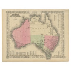
$390
H 14.06 in W 18 in D 0.01 in
1864 Johnson
s Map of New York State with City Insets
Located in Langweer, NL
Title: 1864 Johnson's Map of New York State with City Insets
Description: This 1864 map, titled "Johnson's New York," was published by Johnson and Ward and features a detailed depic...
Category
Antique 1860s Maps
Materials
Paper

$265 Sale Price
20% Off
H 17.13 in W 26.78 in D 0 in
More From This Seller
View All1625 Mercator Map of the Provenience of Quercy, "Quercy Cadvrcivm Ric.0013
Located in Norton, MA
1625 Mercator map of the provenience of Quercy, entitled
"Quercy Cadvrcivm,"
Ric.0013
" Authentic" - Map of the provenience of Quercy Cadvrcivm
D...
Category
Antique 17th Century French Maps
Materials
Paper

1590 Mercator Map Entitled "France Picardie Champaigne, Ric.0001
Located in Norton, MA
Description: Published in Amsterdam by Mercator/Hondius ca. 1590.
Ric.0001
Artists and Engravers: Map : 'France Picardie Champaigne cum regionibus adiacentibus'. (Map of the french provinces of Picardie and Champagne.) Copper engraved map of the french provinces of Picardie and Champagne, showing the cities of Caen, Paris, Melun, Auxerre, Verdun, etc. Copperplate engraving on verge type hand laid paper with watermark. Description: Published in Amsterdam by Mercator/Hondius ca. 1600.Artists and Engravers: Mercator was born in Rupelmonde in Flanders and studied in Louvain under Gemma Frisius, Dutch writer, astronomer and mathematician. The excellence of his work brought him the patronage of Charles V, but in spite of his favor with the Emperor he was caught up in the persecution of Lutheran protestants and charged with heresy, fortunately without serious consequences. No doubt the fear of further persecution influenced his move in 1552 to Duisburg, where he continued the production of maps, globes and instruments. Mercator's sons and grandsons, were all cartographers and made their contributions in various ways to his atlas. Rumold, in particular, was responsible for the complete edition in 1595. The map plates...
Category
Antique 16th Century Dutch Maps
Materials
Paper

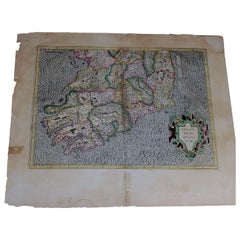
1585 Mercator Map of Ireland, Entitled "Irlandiae Regnvm, " Hand Colored Ric0006
Located in Norton, MA
1585 Mercator map of Ireland, entitled
"Irlandiae Regnvm."
Hand Colored
Description: Published in Amsterdam by Mercator/Hondius ca. 1585.
Artists and Engravers: 1585 Mercator map of Ireland, entitled "Irlandiae Regnvm." Copperplate engraving on verge type hand laid paper with watermark. Description: Published in Amsterdam by Mercator/Hondius ca. 1585.Artists and Engravers: Mercator was born in Rupelmonde in Flanders and studied in Louvain under Gemma Frisius, Dutch writer, astronomer and mathematician. The excellence of his work brought him the patronage of Charles V, but in spite of his favor with the Emperor he was caught up in the persecution of Lutheran protestants and charged with heresy, fortunately without serious consequences. No doubt the fear of further persecution influenced his move in 1552 to Duisburg, where he continued the production of maps, globes and instruments. Mercator's sons and grandsons, were all cartographers and made their contributions in various ways to his atlas. Rumold, in particular, was responsible for the complete edition in 1595. The map plates...
Category
Antique 16th Century Dutch Maps
Materials
Paper
1627 Hendrik Hondius Map Entitled "Vltoniae Orientalis Pars, " Ric.a009
Located in Norton, MA
1627 Hendrik Hondius map entitled
"Vltoniae orientalis pars,"
Ric.a009
Title:
Vltoniae orientalis : pars
Title (alt.) :
Ultoniae orientalis pars
Creator:
Mercator, Gerh...
Category
Antique 17th Century Dutch Maps
Materials
Paper

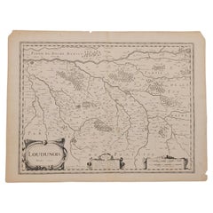
1627 Map Entitled "Loudunois, " Signed on the Back, Ric.a013
Located in Norton, MA
1627 map entitled
"Loudunois,"
Signed on the Back
Ric.a013
cartography close up double-page hand-colored elevated view no person print hand-tinted hilly close-up early 17th-...
Category
Antique 17th Century Dutch Maps
Materials
Paper
1814 Map of "Russian Empire" Ric.r032
Located in Norton, MA
1814 Map of
"Russian Empire"
Ric.r032
Russian Empire. Description: This is an 1814 John Thomson map of the Russian Empire. The map depicts the region from the Baltic Sea, Prussia, and Sweden to the Aleutian Islands and from the Arctic Ocean to the Yellow River. Highly detailed, myriad cities, towns, and villages are labeled throughout, including St. Petersburg, Moscow, Minsk, Kiev, and Kharkov. Rivers and mountain ranges are also identified, as are islands and numerous locations along the coastlines. It is important to note that the long-disputed sea between Korea and Japan is identified as the 'Sea of Japan.
Historical Context:
In 1815, Tsarist Russia emerged from the Napoleonic Wars economically insolvent and politically fearful of the Revolutionary fervor that had just swept through Europe. In order to shore up Russia's economic position, the Tsars began an aggressive series of expansions into the Caucuses and Central Asia that would vastly increase the landmass of the Russian Empire.
Publication History
Thomson maps are known for their stunning color, awe inspiring size, and magnificent detail. Thomson's work, including this map, represents some of the finest cartographic art...
Category
Antique 19th Century Unknown Maps
Materials
Paper

Still Thinking About These?
All Recently ViewedMore Ways To Browse
Antique Water Wagon
Tunisia Antique Map
Used Office Furniture Rhode Island
Antique Chesapeake Bay Map
Antique Copper Australia
Antique Furniture Pondicherry
Antique Map Of Cornwall
Antique Maps Dublin
Antique Maps Of Malta
Antique Saudi Arabia
Armenia Map
Cambodia Antique Map
Coronelli Globe
Denoyer Geppert Anatomy
E Fletcher
Framed Africa Maps
Gabon Antique Map
Hudson River Map