Items Similar to 1866 "Johnson
s United States" Map, Published by Johnson and Ward


Want more images or videos?
Request additional images or videos from the seller
1 of 9
1866 "Johnson
s United States" Map, Published by Johnson and Ward
$1,850
£1,407.58
€1,621.82
CA$2,626.42
A$2,817.68
CHF 1,511.35
MX$33,924.49
NOK 19,052.28
SEK 17,373.04
DKK 12,117.14
About the Item
Presented is a detailed map of the United States by A. J. Johnson. Spanning the whole of the continental United States, as well as adjacent parts of Canada and Mexico, the map reflects the country just after the end of the Civil War. This map, although copyrighted to 1864, was published as page numbers 20 and 21 in the 1866 edition of “Johnson’s New Illustrated (Steel Plate) Family Atlas.” It was published by Johnson and Ward in New York.
The map is incredibly detailed, with towns, cities, railroads, topography, and forts all labelled and depicted. It is surrounded by an intricate fretwork border, found on all Johnson atlas maps from 1863 to 1869. The map is hand colored, with a light watercolor wash, in shades of pink, green, and yellow.
Looking west from the Mississippi River, many of the Western states are still in early configurations or shown with their territory borders. The Dakotas are a single large territory. Oklahoma is named the “Indian Territory.” Wyoming is labeled in outline text only, as it did not become a territory until 1868. Wyoming's northwest boundary juts out into Idaho, while Idaho extends into parts of present-day southwestern Wyoming, including Jackson Hole and the Grand Tetons. In the Southwest, Arizona includes the southern tip of Nevada.
Several important transcontinental routes are noted on the map. All four of the proposed routes for the Pacific Railroad are shown, including Governor Stevens’ route or the Northern Pacific Route, the Central Pacific Route, the Union Pacific Route, and the Southern Pacific Route. The map also notes the course of the Santa Fe Trail, the Pony Express or U.S. Mail Route, and the tracks of Fremont and Marcy.
CONDITION:
Good condition overall. Contemporary color with light toning and minor dampstains that enter the image at left and right. There are archival repairs to a short edge tear at top and a 6" centerfold separation at bottom, since stabilized. Map Dimensions: 17.1”H x 23.3” W. Archival framing in a custom-built wooden frame with UV glass and acid-free mats.
Framed Dimensions: 22 5/8" H x 28 3/4" W x 1" D.
Accompanied by our company's letter of authenticity.
- Dimensions:Height: 22.63 in (57.49 cm)Width: 28.75 in (73.03 cm)Depth: 1 in (2.54 cm)
- Style:Victorian (Of the Period)
- Materials and Techniques:
- Place of Origin:
- Period:
- Date of Manufacture:1866
- Condition:Additions or alterations made to the original: Framed to archival and conservation standards by Artem Art Services in Colorado Springs, CO in September of 2025. Wear consistent with age and use.
- Seller Location:Colorado Springs, CO
- Reference Number:Seller: M3901stDibs: LU909746600762
About the Seller
4.9
Platinum Seller
Premium sellers with a 4.7+ rating and 24-hour response times
Established in 2010
1stDibs seller since 2011
474 sales on 1stDibs
Typical response time: 5 hours
- ShippingRetrieving quote...Shipping from: Colorado Springs, CO
- Return Policy
More From This Seller
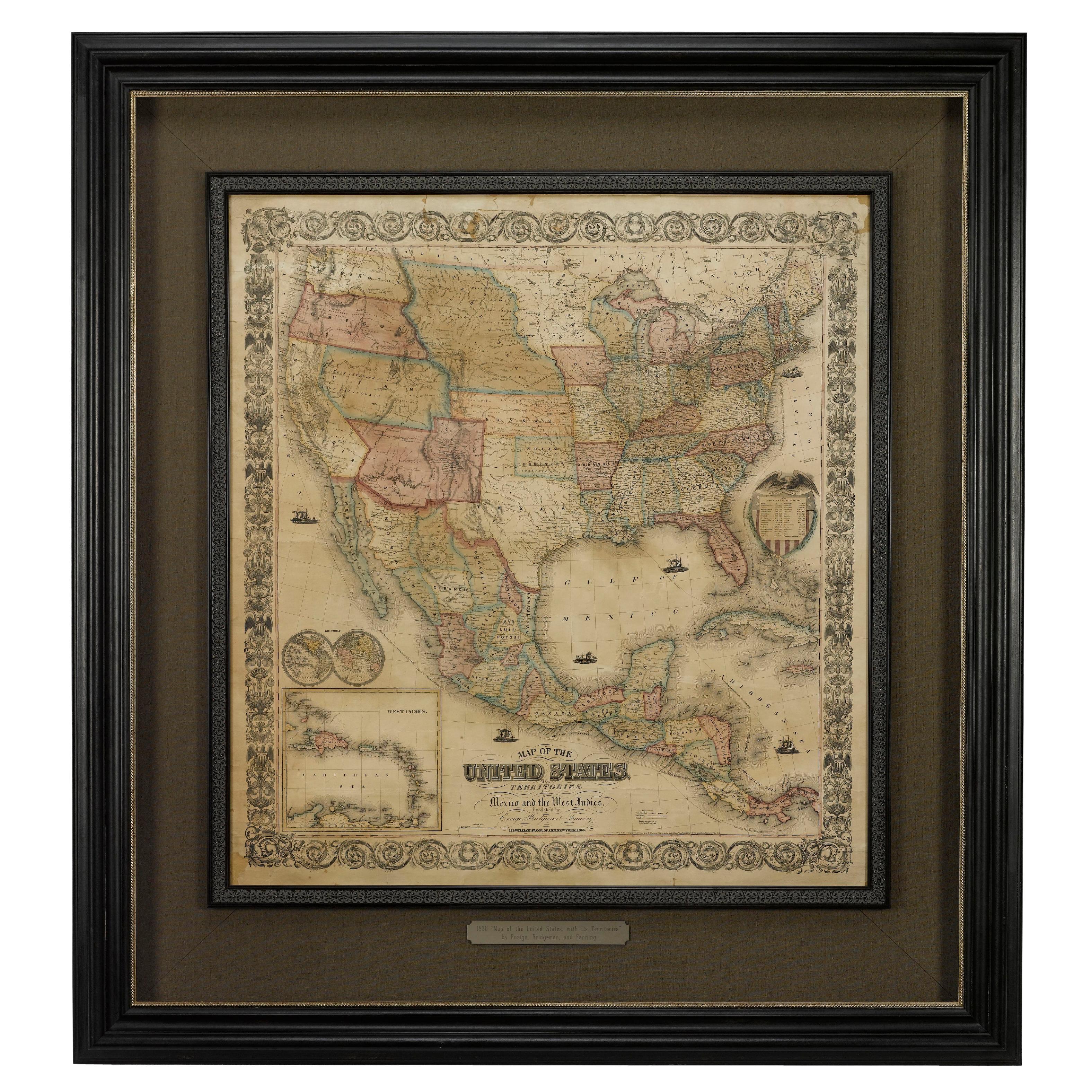
View All1856 "Map of the United States" by Ensign, Bridgeman, and Fanning
Located in Colorado Springs, CO
Presented is a scarce American wall map of the United States and Mexico issued by Ensign, Bridgman, and Fanning in 1856. As the title suggests, the map covers all of the United State...
Category
Antique 1850s American Victorian Maps
Materials
Paper

1859 "Map of the United States of America..." by J. H. Colton
By J.H. Colton
Located in Colorado Springs, CO
Presented is an 1859 “Map of the United States of America, the British Provinces, Mexico, the West Indies and Central America with Part of...
Category
Antique 1850s American Maps
Materials
Paper

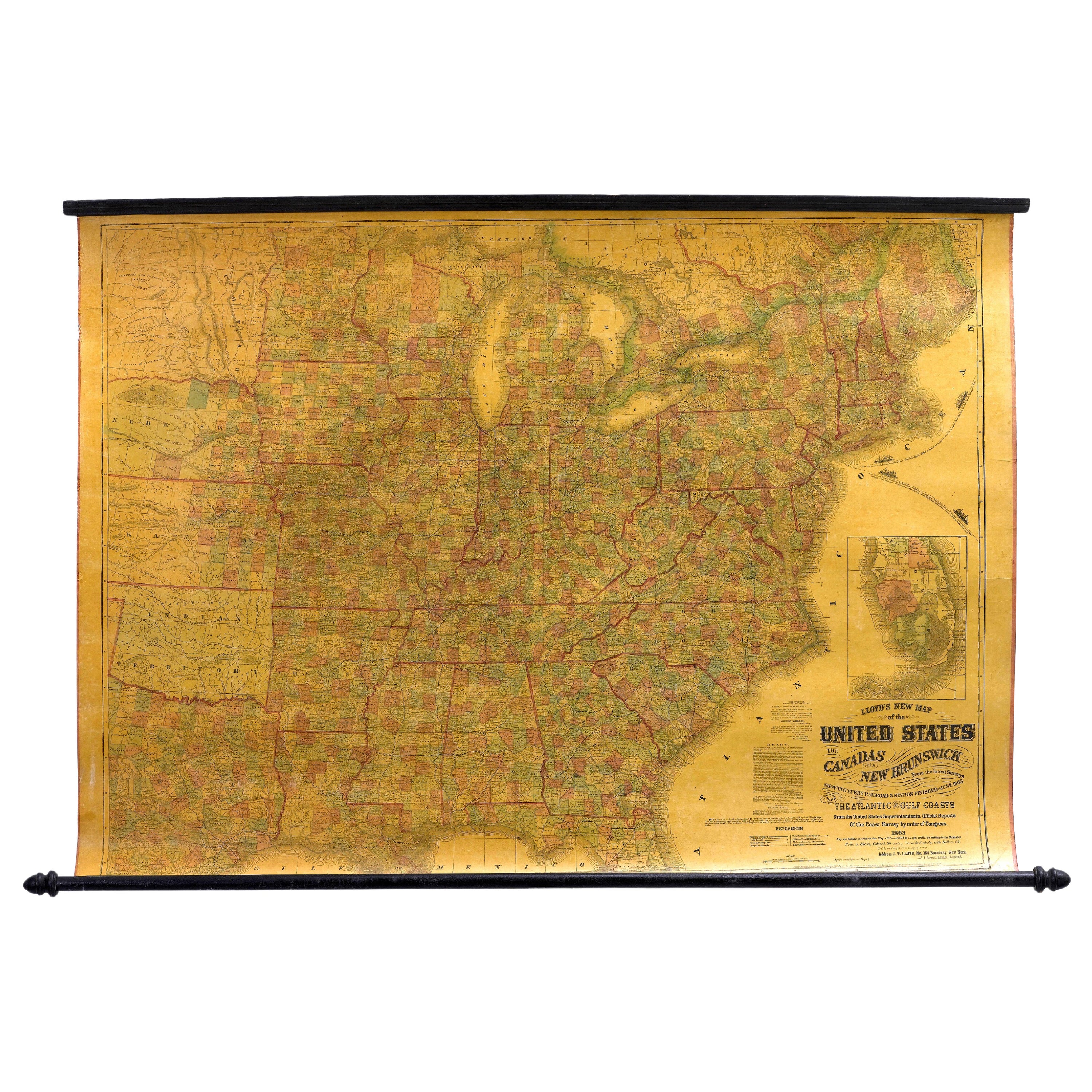
1863 "Lloyd
s New Map of the United States, the Canadas, and New Brunswick"
Located in Colorado Springs, CO
Presented is “Lloyd's New Map of the United States, the Canadas and New Brunswick, From the latest Surveys, Showing Every Railroad & Station Finished to June 1863, and the Atlantic and Gulf Coasts.” A large, Civil War-era hanging map of the United States and adjacent territories, this map covers the area from the Atlantic Ocean and extends as far west as the 103 meridian, to “Dacotah,” Nebraska, Kansas, "Indian Territory," and Texas. The southern continuation of Florida is shown in an inset map along the right margin. This map was published by J. T. Lloyd, in New York, in 1863. According to the publisher’s marking at lower right, this map was originally issued in two states: "in Sheets, Colored" for 50 cents, and "Varnished nicely, with Rollers" for $1.
Throughout the map, the counties are colored and the towns and cities well labeled. A reference key in the bottom margin provides symbols for railroads, turnpikes and wagon roads, state capitals, cities and towns, and village post offices. As emphasized in the map’s title, this map is especially notable for the countless railway lines and stations depicted, with distances noted between points, listing “every railroad and finished station to June 1863.” Additionally, two shipping agents and their routes are drawn out of New York City. The map includes details of the steamship routes into New York and Philadelphia from Liverpool and on to California and Oregon via an overland Nicaraguan trek, presumably to assist gold rush emigrants.
This expansive and impressive map depicts the eastern half of the United States in the third year of the Civil War. In order not to recognize the legitimacy of the Confederate States of America, each state is shown in the same manner as the Union states. The only indication that the American Civil War was in progress when this map was published is a printed notice that Gideon Wells, Secretary of the Navy, wishes to acquire a quote on 100 copies of Lloyd’s Mississippi River map...
Category
Antique 1860s American Maps
Materials
Linen, Wood, Paper

1866 Ensign
Bridgman
s Rail Road Map of the United States
Located in Colorado Springs, CO
Presented is an 1866 issue of “Ensign & Bridgeman’s Rail Road Map of the United States, showing Depots & Stations.” First published in 1856, this is the third edition, following anot...
Category
Antique 1860s American Late Victorian Maps
Materials
Paper

1864 Map of North America, Antique Hand-Colored Map, by Adolphe Hippolyte Dufour
Located in Colorado Springs, CO
Offered is a map of North America entitled Amerique du Nord from 1864. This rare, separately published wall map was produced by Adolphe Hippolyte Dufour. This map includes vibrant an...
Category
Antique 1860s French Maps
Materials
Paper

"The United States from the Latest Authorities" Antique Wall Map, 1835
Located in Colorado Springs, CO
This is a 1835 map of “The United States from the Latest Authorities” by Ezra Strong. A hand-colored engraved wall map of the eastern half of the United States, this map has a large inset of the "Oregon District" and several engraved city views and two portraits.
The primary map extends to Mexico Texas and the Missouri Territory, showing the course of the Missouri River to Ft. Mandan and Old Ft. Mandan, and noting many forts along the river. The territories to the east of Missouri Territory are separately delineated as Sioux District and Huron District. The western details of the map are very good for a map of this time period, with many Native American settlements, villages, forts and other details noted.
The map is bordered with vignettes of Boston, New York, Philadelphia, Hartford, Cincinnati, and Baltimore. Each vignette notes the date settled, primary settler, and the population as of 1830. Two portraits of LaFayette and George Washington are presented in full length with related biographical information.
A large inset map at lower right shows the Oregon District, centered on the Columbia River and extending to the Rocky Mountains. This is one of the earliest commercial appearances of a separate map of Oregon...
Category
Antique 1830s American Maps
Materials
Paper

You May Also Like
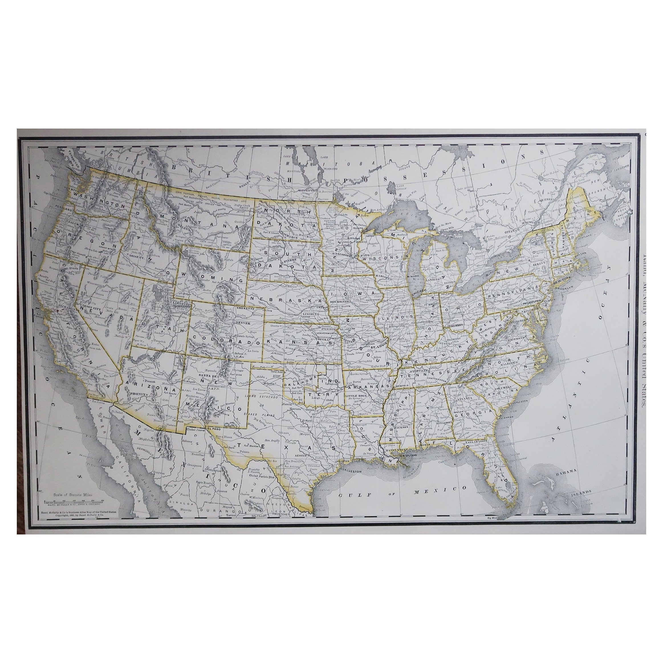
Large Original Antique Map of the United States of America. 1891
By Rand McNally
Co.
Located in St Annes, Lancashire
Fabulous map of The United States
Original color
By Rand, McNally & Co.
Dated 1891
Unframed
Free shipping.
Category
Antique 1890s American Maps
Materials
Paper

Original Antique Map of United States, Grattan and Gilbert, 1843
Located in St Annes, Lancashire
Great map of United States
Drawn and engraved by Archer
Published by Grattan and Gilbert. 1843
Original colour
Unframed.
Category
Antique 1840s English Maps
Materials
Paper

Antique Map of the United States by Titus
1871
Located in Langweer, NL
Antique map titled 'The United States of America'. Original antique map of the United States. This map originates from 'Atlas of Prebl...
Category
Antique Late 19th Century Maps
Materials
Paper

$759 Sale Price
20% Off
Antique Map of the United States of North America, c.1882
Located in Langweer, NL
Antique map titled 'United States of North America'. Old map of the United States of North America. This map originates from 'The Royal Atlas of Modern Geography, Exhibiting, in a Se...
Category
Antique 1880s Maps
Materials
Paper

Antique 1844 J Calvin Smith JH Colton Midwest United States Survey Map 27"
By J.H. Colton
Located in Dayton, OH
Antique framed black and white map of seven Midwestern American states. Guide Through Ohio, Michigan, Indiana, Illinois, Missouri, Wisco...
Category
Antique 1840s Maps
Materials
Paper

$822 Sale Price
30% Off
Antique Railroad Map of the United States by Rand, McNally
Co, 1900
Located in Langweer, NL
Antique map titled 'Rand, McNally & Co's New Official Railroad map of the United States with portions of The Dominion of Canada, The Republic of Mexico and the West Indies'. Large railroad map of the United States, sectionalised and laid on linen. Map shows state boundaries for the United States, Mexico, the West Indies, and lower portion of Canada; major cities and towns, military posts, Native American reservations, and railroads; Oklahoma and "Indian Territory." Inset: "Map of Alaska...
Category
20th Century Maps
Materials
Linen, Paper

$2,224 Sale Price
25% Off
Free Shipping