Want more images or videos?
Request additional images or videos from the seller
1 of 6
1870 "40 Miles Around New York" by H. H. Lloyd, Hanging Map on Original Rollers
$3,500List Price
About the Item
- Dimensions:Height: 31 in (78.74 cm)Width: 28.75 in (73.03 cm)Depth: 1 in (2.54 cm)
- Style:Late Victorian (Of the Period)
- Materials and Techniques:
- Place of Origin:
- Period:
- Date of Manufacture:1870
- Condition:Repaired: Archival stabilization of cracks and reinforced attachment to top wooden roller by Art Source International Framing in Boulder, Colorado, in March of 2020. Wear consistent with age and use. Minor structural damages. Minor fading.
- Seller Location:Colorado Springs, CO
- Reference Number:Seller: M2961stDibs: LU909742502842
About the Seller
4.9
Platinum Seller
Premium sellers with a 4.7+ rating and 24-hour response times
Established in 2010
1stDibs seller since 2011
474 sales on 1stDibs
Typical response time: 2 hours
Authenticity Guarantee
In the unlikely event there’s an issue with an item’s authenticity, contact us within 1 year for a full refund. DetailsMoney-Back Guarantee
If your item is not as described, is damaged in transit, or does not arrive, contact us within 7 days for a full refund. Details24-Hour Cancellation
You have a 24-hour grace period in which to reconsider your purchase, with no questions asked.Vetted Professional Sellers
Our world-class sellers must adhere to strict standards for service and quality, maintaining the integrity of our listings.Price-Match Guarantee
If you find that a seller listed the same item for a lower price elsewhere, we’ll match it.Trusted Global Delivery
Our best-in-class carrier network provides specialized shipping options worldwide, including custom delivery.You May Also Like
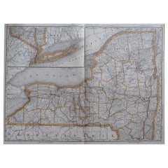
Large Original Antique Map of New York, USA, 1894
By Rand McNally
Co.
Located in St Annes, Lancashire
Fabulous map of New York.
Original color.
By Rand, McNally & Co.
Published, 1894
Unframed
Free shipping.
Category
Antique 1890s American Maps
Materials
Paper
Antique Map of New Zealand by A
C. Black, 1870
Located in Langweer, NL
Antique map titled 'New Zealand'. Original antique map of New Zealand with inset Maps of Australia, New Zealand and Tasmania. This map origi...
Category
Antique Late 19th Century Maps
Materials
Paper

Rare Original Map of New Amsterdam (New York) – “Restitutio”, ca. 1674 –
Located in Dronten, NL
An exceptionally rare and original 17th-century engraving of New Amsterdam, now New York City, published by the renowned Amsterdam cartographer Carel (Carolus) Allard around 1674. Kn...
Category
Antique 17th Century Dutch Maps
Materials
Paper

$24,950
H 20.16 in W 23.35 in D 0.4 in
Antique Map of New York by Johnson
1872
Located in Langweer, NL
Antique map titled 'Johnson's New York'. Original map showing New York, with an inset map of Long Island. This map originates from 'Johnson's New Il...
Category
Antique Late 19th Century Maps
Materials
Paper

Large Original Antique Map of New York State ( Northern ), USA, C.1900
Located in St Annes, Lancashire
Fabulous map of Northern New York
Original color.
Engraved and printed by the George F. Cram Company, Indianapolis.
Published, C.1900.
Unframed.
Repairs to minor edge tears
Fr...
Category
Antique 1890s American Maps
Materials
Paper
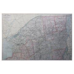
$90
Free Shipping
H 15 in W 22 in D 0.07 in
Large Original Antique Map of New York State( Southern ), USA, C.1900
Located in St Annes, Lancashire
Fabulous map of Southern New York . With a vignette of Lower Manhattan
Original color.
Engraved and printed by the George F. Cram Company, Indianapolis.
Published, C.1900.
Unfram...
Category
Antique 1890s American Maps
Materials
Paper

$90
Free Shipping
H 15 in W 22 in D 0.07 in
Large Antique Map of New York State with Inset Maps
Located in Langweer, NL
Antique map titled 'Johnson's New York' Large map of New York State. With insets of Albany, Oswego, Buffalo, Rochester, Syracuse, Troy and NYC. Published by Johnson and Browning, 186...
Category
Antique Mid-19th Century Maps
Materials
Paper

$465 Sale Price
20% Off
H 18.04 in W 26.58 in D 0.02 in
1862 Johnson
s Map of New York State by Johnson
Browning
Located in Langweer, NL
Title: 1862 Johnson's Map of New York State by Johnson & Browning
Description:This is an 1862 map of New York State, titled "Johnson's New York," created by Johnson & Browning. The ...
Category
Antique 1860s Maps
Materials
Paper

$265 Sale Price
20% Off
H 14.18 in W 18.12 in D 0 in
Thomas Mills
Brother Confectioners Roller, c.1870
Located in Savannah, GA
A heavy bronze confectoners roller made by Thomas Mills & Brother, Philadelphia, circa 1870.
25 inches wide by 3 ½ inches thick; weighing 15 ½ lbs.
Category
Antique 1870s American Historical Memorabilia
Materials
Bronze

Vintage Oversized New York City Lower Manhattan 1840s Map Print
Located in Dayton, OH
Vintage late 20th century reproduction print of New York City featuring lower Manhattan in 1840.
Category
Late 20th Century Victorian Maps
Materials
Paper

$700 Sale Price
30% Off
H 61 in W 49 in D 1 in
More From This Seller
View All1868 "Lloyd
s Topographical Railway Map of North America..." Hanging Wall Map
Located in Colorado Springs, CO
Presented is “Lloyd's Topographical Railway Map of North-America, or the United States Continent in 1900.” This map was published by J. T. Lloyd, in New York, in 1868. A large, hangi...
Category
Antique 1860s American Late Victorian Maps
Materials
Linen, Paper

1855 "New-York City
County Map" by Charles Magnus
By Charles Magnus
Located in Colorado Springs, CO
This is a beautiful hand-colored map titled “New York City & County Map with Vicinity entire Brooklyn, Williamsburgh, Jersey City &c.” The work was published in 1855 by Charles Magnu...
Category
Antique 1850s American Maps
Materials
Paper

1870 "Johnson
s Europe" Map Published by A. J. Johnson
Located in Colorado Springs, CO
Presented is an original 1870 "Johnson’s Europe" map. First published in 1864, this map was issued as pages 87 and 88 in the 1870 edition of “Johnson's New Illustrated (Steel Plate) ...
Category
Antique 1870s American Victorian Maps
Materials
Paper

1863 "Lloyd
s New Map of the United States, the Canadas, and New Brunswick"
Located in Colorado Springs, CO
Presented is “Lloyd's New Map of the United States, the Canadas and New Brunswick, From the latest Surveys, Showing Every Railroad & Station Finished to June 1863, and the Atlantic and Gulf Coasts.” A large, Civil War-era hanging map of the United States and adjacent territories, this map covers the area from the Atlantic Ocean and extends as far west as the 103 meridian, to “Dacotah,” Nebraska, Kansas, "Indian Territory," and Texas. The southern continuation of Florida is shown in an inset map along the right margin. This map was published by J. T. Lloyd, in New York, in 1863. According to the publisher’s marking at lower right, this map was originally issued in two states: "in Sheets, Colored" for 50 cents, and "Varnished nicely, with Rollers" for $1.
Throughout the map, the counties are colored and the towns and cities well labeled. A reference key in the bottom margin provides symbols for railroads, turnpikes and wagon roads, state capitals, cities and towns, and village post offices. As emphasized in the map’s title, this map is especially notable for the countless railway lines and stations depicted, with distances noted between points, listing “every railroad and finished station to June 1863.” Additionally, two shipping agents and their routes are drawn out of New York City. The map includes details of the steamship routes into New York and Philadelphia from Liverpool and on to California and Oregon via an overland Nicaraguan trek, presumably to assist gold rush emigrants.
This expansive and impressive map depicts the eastern half of the United States in the third year of the Civil War. In order not to recognize the legitimacy of the Confederate States of America, each state is shown in the same manner as the Union states. The only indication that the American Civil War was in progress when this map was published is a printed notice that Gideon Wells, Secretary of the Navy, wishes to acquire a quote on 100 copies of Lloyd’s Mississippi River map...
Category
Antique 1860s American Maps
Materials
Linen, Wood, Paper

1840 "New Map of the City of New York With Part of Brooklyn
Williamsburg"
Located in Colorado Springs, CO
Presented is a hand-colored, engraved folding map titled "New Map of the City of New York With Part of Brooklyn & Williamsburg" by J. Calvin Smith. The map was issued bound in the bo...
Category
Antique 1840s American Maps
Materials
Paper

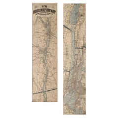
1917 "New Hudson River Map" by Wallace Bruce, Later Edition, Folding Map
Located in Colorado Springs, CO
Presented is a 1917 printing of “New Hudson Map” by Wallace Bruce. The map was published by Bryant Union Publishing Co., in New York City. The map is a later edition, issued in a distinct strip-chart format that is over 100 inches long. The map includes amazing detail, compiled mostly from U.S. Coast Survey data. It is drawn on a scale of 1.5 miles per inch, allowing ample space for it to show historical landmarks, landings, islands, list prominent residents, and more. The verso is filled with related text and illustrations about the Hudson River valley. The map folds into cream paper wrappers, titled "Hudson River Map...
Category
Vintage 1910s American Beaux Arts Maps
Materials
Paper