Items Similar to 1873 Martha
s Vineyard and Nantucket Chart


Want more images or videos?
Request additional images or videos from the seller
1 of 13
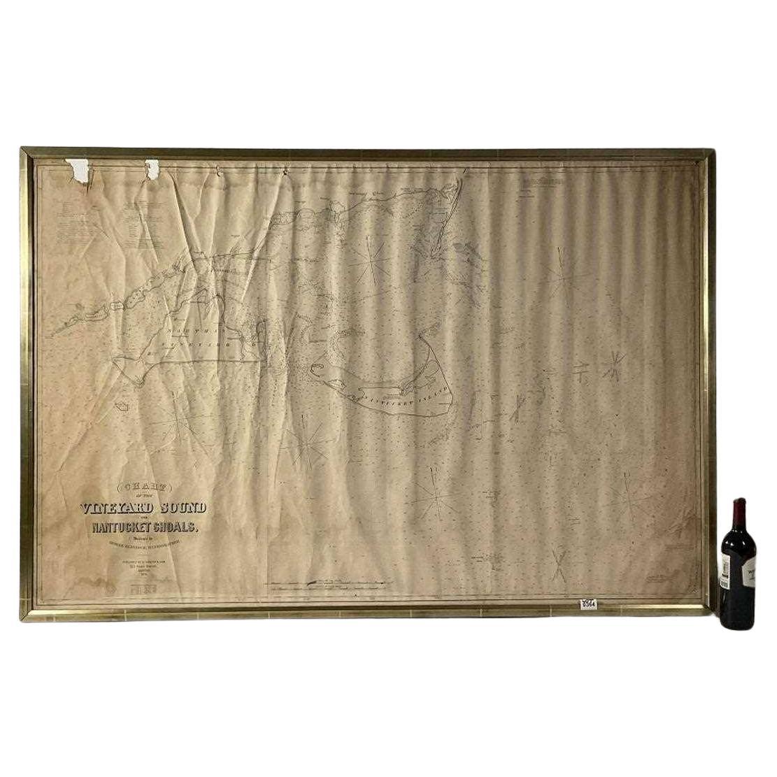
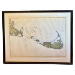
1873 Martha
s Vineyard and Nantucket Chart
$3,895
£2,941.77
€3,398.20
CA$5,487.50
A$5,877.11
CHF 3,159.50
MX$71,380.99
NOK 39,921.78
SEK 36,551.36
DKK 25,390.74
About the Item
Original chart of Nantucket and Martha's Vineyard by George Eldridge, Cartographer, 125 State Street, Boston. Dated 1873. Mounted to canvas. Also showing the coast of Cape Cod including Osterville and Chatnam. Condition: Has areas of paper loss and tears, stains from years at sea. 44" H x 67" W. 21 lbs.
- Dimensions:Height: 44 in (111.76 cm)Width: 67 in (170.18 cm)Depth: 1 in (2.54 cm)
- Materials and Techniques:
- Place of Origin:
- Period:
- Date of Manufacture:1873
- Condition:
- Seller Location:Norwell, MA
- Reference Number:Seller: 24NV2871stDibs: LU1741243338572
About the Seller
5.0
Vetted Professional Seller
Every seller passes strict standards for authenticity and reliability
Established in 1967
1stDibs seller since 2015
434 sales on 1stDibs
Typical response time: 6 hours
- ShippingRetrieving quote...Shipping from: Norwell, MA
- Return Policy
More From This Seller
View All1870 Chart Martha
s Vineyard And Nantucket
Located in Norwell, MA
Nineteenth century 1870 George Eldridge chart titled "Chart Of The Vineyard Sound And Nantucket Shoals", surveyed by George Eldridge hydrographer...
Category
Antique 1870s North American Prints
Materials
Paper
Long Island Chart from 1828
Located in Norwell, MA
Rare original chart of Long Island Sound by E + G Blunt of New York, 179 Water St. "Surveyed in the years 1828, 29 & 30" Exceedingly rare and early chart, titled Long Island Sound fr...
Category
Antique 1830s Nautical Objects
Materials
Paper

Antique Maritime Chart of East Coast Virginia to Nova Scotia
Located in Norwell, MA
1920 nautical chart of the East Coast of the United States from Virginia to Maine, New Brunswick, and Nova Scotia. The chart shows Cape Cod, Long Island, the Connecticut coast, Jersey Shore, Maine, New Hampshire, etc. Very detailed, showing ports, lighthouses, shoals, depths, etc. The chart is by famous cartographer George W. Eldridge, compiled from surveys of the United States government, British Admiralty, George Eldridge, and others. First authorized by George Eldridge, published in 1916 by Wilfred O. White with a merchant's stamp of Charles Hutchinson...
Category
Vintage 1920s North American Maps
Materials
Paper

1898 Chart of Boston Bay
Located in Norwell, MA
Original 1898 chart showing Massachusetts Bay with the coast from Cape Ann to Cape Cod. This is a U.S. Navy Geodetic survey chart. All towns are noted along the coast. Framed with gl...
Category
Antique 1890s Nautical Objects
Materials
Paper

$1,495
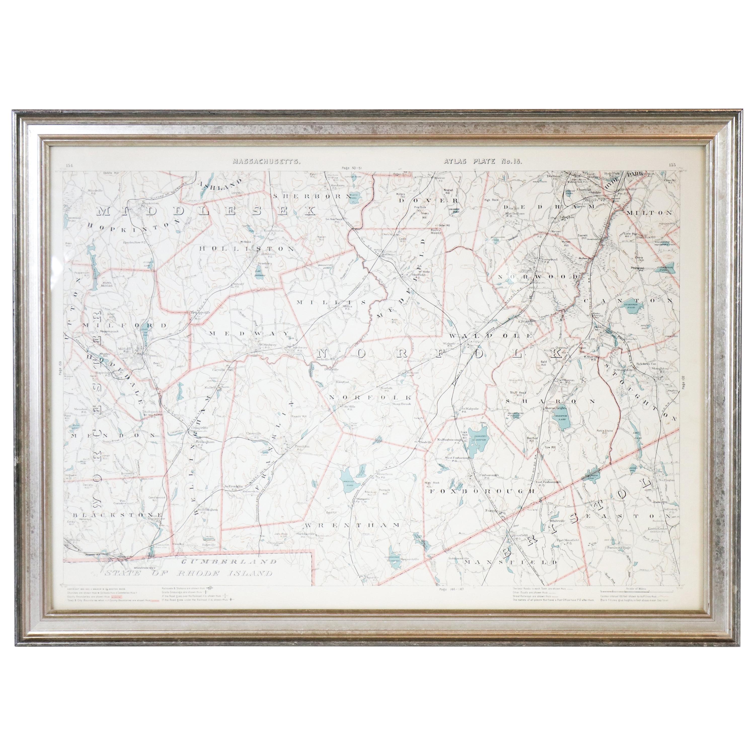
1891 Map of Norfolk County Massachusetts
Located in Norwell, MA
1891 map of Norfolk county Massachusetts including the towns of Wrentham, Franklin, Medfield, Sherborn, Norwood etc., measures: 23 x 31.
Category
Antique 19th Century Maps

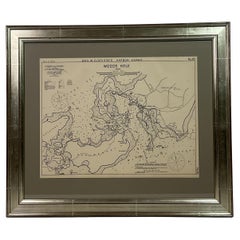
1901 Nautical Chart Showing Woods Hole, Mass
Located in Norwell, MA
Rare 1901 chart of Woods Hole, Mass., showing Buzzards Bay, Penzance Point, Nonamesset Island, Downtown Woods Hole, Parker Neck, Nobska Head, Vineyard Sound, Woods Hole Golf Club, Ra...
Category
Antique Early 1900s North American Maps
Materials
Paper
You May Also Like
Large U.S. Coast and Geodetic Survey Chart A of the Atlantic Coast, 1877
Located in Nantucket, MA
Large U.S. Coast and Geodetic Survey Chart A of the Atlantic Coast, 1877, re-issued in February 1881, a printed paper laid down on linen navigational chart of the U.S. Atlantic coast...
Category
Antique 1880s American Other Maps
Materials
Linen

DesBarres (1776) Chart of Nantucket Island, 1966 Restrike
Located in Nantucket, MA
DesBarres (1776) Chart of Nantucket Island and the Eastern Half of Martha's Vineyard Restrike, published by the Massachusetts Historical Society in association with Haley
Steel...
Category
Vintage 1960s American Other Maps
Materials
Paper
19th Century Chart of New England Coast, 1847
By U.S. Government
Located in Nantucket, MA
19th Century Chart of New England Coast: the U.S. Coast Survey Sketch A - Section 1, a triangulation chart showing the progress of the survey and details along the New England coas...
Category
Antique 1840s American Other Maps
Materials
Paper

Rare 18th C. Newport Map
Located in Sandwich, MA
Rare 18th C, Map titled "A plan of the town of Newport in the province of Rhode Island". Earliest printed plan of Newport, published for the use of the British just prior to their o...
Category
Antique 1770s American Maps
Materials
Paper

$19,500 / item
Nantucket High-Ways, By-Ways and Not-Ways Decorative Map by Tony Sarg, ca 1930
By Tony Sarg
Located in Nantucket, MA
Vintage Nantucket High-Ways, By-Ways and Not-Ways Decorative Map by Tony Sarg, (Nantucket: 1880 - 1942) circa 1930, a decorative tourist map of Nantucket Island with details of roadw...
Category
Vintage 1930s American Other Maps
Materials
Paper

Antique Map of Cordes Bay and Surroundings
Located in Langweer, NL
Antique map titled 'Baye et Havre de Cordes (..)'. Four maps on the one sheet of; Cordes Bay, Port Famine, Woods Pay, Port Gallant, Fortescue Bay, Chile based on the voyage of John B...
Category
Antique Late 18th Century Maps
Materials
Paper
$248 Sale Price
20% Off
More Ways To Browse
Vineyard Furniture
Blue Green Wool And Silk Rug
Brown Sheepskin Chair
Vintage Brass Bar Carts
Antique Botanical Prints
Green Persian Rug
50 X 50 Coffee Table
Milo Baughman 1970
Spanish Baroque Furniture
Stone China
Couch Console
Vintage Burn
Chinese Stone
Sterling Silver Flatware Service For 12
Antique Dining Tables With Leaves
Decorative Wall Panels
Frank Lloyd Wright For Cassina
Natural Curved