Want more images or videos?
Request additional images or videos from the seller
1 of 6
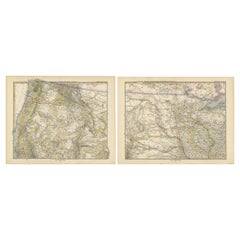
1874 Antique Map of Nebraska, Dakota, Montana, and Wyoming
$1,195List Price
About the Item
- Dimensions:Height: 15.5 in (39.37 cm)Width: 22 in (55.88 cm)Depth: 1.5 in (3.81 cm)
- Materials and Techniques:
- Place of Origin:
- Period:
- Date of Manufacture:1874
- Condition:Wear consistent with age and use.
- Seller Location:Colorado Springs, CO
- Reference Number:Seller: M1521stDibs: LU909717766352
About the Seller
4.9
Platinum Seller
Premium sellers with a 4.7+ rating and 24-hour response times
Established in 2010
1stDibs seller since 2011
474 sales on 1stDibs
Typical response time: 2 hours
Authenticity Guarantee
In the unlikely event there’s an issue with an item’s authenticity, contact us within 1 year for a full refund. DetailsMoney-Back Guarantee
If your item is not as described, is damaged in transit, or does not arrive, contact us within 7 days for a full refund. Details24-Hour Cancellation
You have a 24-hour grace period in which to reconsider your purchase, with no questions asked.Vetted Professional Sellers
Our world-class sellers must adhere to strict standards for service and quality, maintaining the integrity of our listings.Price-Match Guarantee
If you find that a seller listed the same item for a lower price elsewhere, we’ll match it.Trusted Global Delivery
Our best-in-class carrier network provides specialized shipping options worldwide, including custom delivery.You May Also Like
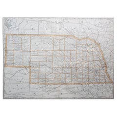
Antique Map of Nebraska
Located in Langweer, NL
Antique map titled 'Nebraska'. Original antique map of Nebraska, United States. This print originates from 'Encyclopaedia Britannica', Ninth Edition. Pu...
Category
Antique Late 19th Century Maps
Materials
Paper

Set of two Antique Maps of Oregon, Idaho, Wyoming, Nebraska
Iowa, ca.1879
Located in Langweer, NL
Set of two individual antique maps of part of the United States. It shows the region and surroundings of Oregon, Idaho, Wyoming, Nebraska, Iowa, Dakota and Wisconsin. Published as pa...
Category
Antique Late 19th Century German Maps
Materials
Paper
$455 Sale Price / set
20% Off
H 15.12 in W 18.82 in D 0.02 in
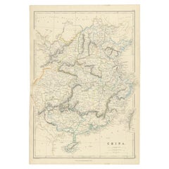
Antique Map of China, 1874
Located in Langweer, NL
Antique map titled 'China'. Detailed map of China originates from Blackie's 'The Comprehensive Atlas & Geography of the World'.
Artists and Engravers: ...
Category
Antique 19th Century Maps
Materials
Paper
Antique Map of Iowa and Nebraska by Johnson,
1872
Located in Langweer, NL
Antique map titled 'Johnson's Iowa and Nebraska'. Original map of Iowa and Nebraska. This map originates from 'Johnson's New Illustrated Family Atlas of th...
Category
Antique Late 19th Century Maps
Materials
Paper

Large Original Antique Map of Nebraska, USA, 1894
By Rand McNally
Co.
Located in St Annes, Lancashire
Fabulous map of Nebraska
Original color
By Rand, McNally & Co.
Published, 1894
Unframed
Some slight restoration to the Gosper / Furnas area. Seen in the last image
Free shipping.
Category
Antique 1890s American Maps
Materials
Paper
Antique Map of Russia and Surroundings by Stieler, 1874
Located in Langweer, NL
Antique map titled 'Nord- & Mittal-Asien, Ubersicht des Russischen Reiches.' A map of Russia in scale 1:20.000.000. The depicted area spans from Iran and Sweden in the left edge of t...
Category
Antique 19th Century Maps
Materials
Paper

$66 Sale Price
20% Off
H 14.97 in W 19.1 in D 0 in
Original Antique Map of the American State of Nebraska, 1903
Located in St Annes, Lancashire
Antique map of Nebraska
Published By A & C Black. 1903
Original colour
Good condition
Unframed.
Free shipping
Category
Antique Early 1900s English Maps
Materials
Paper

$49
Free Shipping
H 11.5 in W 16.25 in D 0.07 in
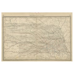
Nebraska Railroad Map 1888 – Rand McNally Antique Lithograph
Located in Langweer, NL
Nebraska Railroad Map 1888 – Rand McNally Antique Lithograph
This finely detailed map of Nebraska, published by Rand, McNally & Co. in 1888, provides an excellent overview of the st...
Category
Antique Late 19th Century American Maps
Materials
Paper
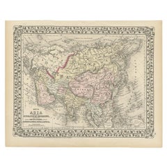
Antique Map of Asia Showing Its Political Divisions, 1874
Located in Langweer, NL
Antique map titled 'Map of Asia showing its Gt. Political Divisions and also the various routes of Travel between London & India, China & Japan & c'. This map covers from the Arabian...
Category
Antique 19th Century Maps
Materials
Paper
Vintage 1862 Map of Iowa and Nebraska – Decorative Atlas Print
Located in Langweer, NL
Antique Map of Iowa and Nebraska by Johnson and Ward, 1862
This beautifully detailed antique map, published in 1862, depicts the states of Iowa and Nebraska during the mid-19th cent...
Category
Antique 1860s Maps
Materials
Paper
More From This Seller
View All1854 Map of Massachusetts, Connecticut and Rhode Island, Antique Wall Map
Located in Colorado Springs, CO
This striking wall map was published in 1854 by Ensign, Bridgman & Fanning and has both full original hand-coloring and original hardware. This impression is both informative and highly decorative.
The states are divided into counties, outlined in red, green, and black, and subdivided into towns. Roads, canals, and railroad lines are prominently depicted, although they are not all labeled. The mapmakers also marked lighthouses, banks, churches, and prominent buildings, with a key at right. The map is an informative and comprehensive overview of the infrastructural development of New England prior to the Civil War. Physical geographies depicted include elevation, conveyed with hachure marks, rivers and lakes. The impression features an inset map of Boston...
Category
Antique 19th Century American Maps
Materials
Paper

1847 Antique Map of Mexico, Texas and California by Samuel Augustus Mitchell
By Samuel Augustus Mitchell 1
Located in Colorado Springs, CO
Presented is the second edition of Samuel Augustus Mitchell's Map of Mexico, Including Yucatan & Upper California, an important map showing the progress of the Mexican-American War. ...
Category
Antique 1840s American Maps
Materials
Paper

1864 Map of North America, Antique Hand-Colored Map, by Adolphe Hippolyte Dufour
Located in Colorado Springs, CO
Offered is a map of North America entitled Amerique du Nord from 1864. This rare, separately published wall map was produced by Adolphe Hippolyte Dufour. This map includes vibrant an...
Category
Antique 1860s French Maps
Materials
Paper

Plan of Paris, France, by A. Vuillemin, Antique Map, 1845
Located in Colorado Springs, CO
This large and detailed plan of Paris was published by Alexandre Vuillemin in 1845. The map conveys a wonderful amount of information and is decorated throughout with pictorial vigne...
Category
Antique 1840s American Maps
Materials
Paper

1845 "Ensign
s Travellers
Guide and Map of the United States" Hand-Colored Map
Located in Colorado Springs, CO
This is an exquisite and dramatic steel-engraved wall map of the United States, published by T.
E. H. Ensign in 1845. The map depicts the development and settlement of the Unit...
Category
Antique 1840s American Victorian Maps
Materials
Paper

1899 Poole Brothers Antique Railroad Map of the Illinois Central Railroad
Located in Colorado Springs, CO
This is an 1899 railroad map of the Illinois Central and Yazoo and Mississippi Valley Railroads, published by the Poole Brothers. The map focuses on the continuous United States from the Atlantic to the Pacific Oceans, the Gulf of Mexico, and the Antilles. Remarkably detailed, the rail routes of the Illinois Central RR are marked in red, which each stop labeled. Major stops are overprinted in red, bold letters, with the short rail distances to New York listed above the stop and short rail distances to New Orleans listed below the name.
In addition to the Illinois Central network, numerous different rail lines are illustrated and the company running that line is noted along with many stops along each route. Sea routes from New Orleans to locations in Central America, the Caribbean, and Europe are marked and labeled with destination and distance, along with routes originating from Havana. Inset at bottom left is a map of Cuba; an inset map of Puerto Rico...
Category
Antique 1890s American Maps
Materials
Paper
