Items Similar to 1876 Map of the United States: Detailing the Railroads and Unsettled Territories

Want more images or videos?
Request additional images or videos from the seller
1 of 12
1876 Map of the United States: Detailing the Railroads and Unsettled Territories
$1,044.17
£779.52
€880
CA$1,450.67
A$1,560.40
CHF 833.92
MX$18,392.68
NOK 10,513.82
SEK 9,611.63
DKK 6,706.59
About the Item
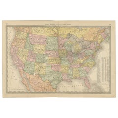
Stanford’s Smaller Railway Map of the United States, 1876
This original 1876 map, titled "Stanford's Smaller Railway Map of the United States Distinguishing the Unsettled Territories; The Railways; The Cities and Towns According to Population," is a lithographed and hand-colored work that provides a detailed overview of the railway networks and demographic distribution of the era.
Measuring 460 x 760 mm (18 x 29 3/4 in), it is dissected and mounted on linen, suggesting durability and ease of use. The map is detailed with minor surface dirt evident, indicative of its age and historical value. It folds neatly into original cloth boards, which are worn but hold significant historical charm. The cover is adorned with the publisher’s yellow label, identifying its origins and authenticity. This artifact not only serves as a functional railway map but also as a historical document, reflecting the developmental state of the United States during the late 19th century.
The map reflects the United States during a pivotal era in its development. Here are some important elements and places as depicted on the map:
1. Railways: The extensive network of railways highlighted indicates the rapid expansion and importance of rail transport across the continent, crucial for economic growth and the settlement of new areas.
2. Unsettled Territories: Large portions of the map, particularly in the west, are marked as unsettled territories. This reflects ongoing westward expansion and the impact of the Homestead Act of 1862, which encouraged the settlement of these areas.
3. Cities and Towns: The map distinguishes cities and towns according to population, giving insight into urban development at the time. Major cities like New York, Chicago, and San Francisco are likely marked as significant urban centers.
4. State Boundaries: The boundaries of states and territories are clearly demarcated, some of which would have been relatively new or still in flux at the time, such as those in the West following the conclusion of various territorial disputes and rearrangements.
5. Geographic Features: Major rivers, mountain ranges, and other natural landmarks are also likely depicted, which were important for navigation, settlement, and defining territorial claims.
Status of the United States in 1876:
The year 1876 was a significant one in American history, marked by several key events and characteristics:
- Centennial Year: It was the 100th anniversary of the Declaration of Independence, celebrated with the Centennial Exposition in Philadelphia, the first official World's Fair in the United States.
- Reconstruction Era: The country was in the latter stages of the Reconstruction Era following the Civil War. This period was characterized by significant political, social, and economic upheaval, particularly in the Southern states.
- Westward Expansion: The continued push westward was facilitated by the completion of the Transcontinental Railroad in 1869, spurring further development and conflicts with Native American tribes.
- Industrial Growth: The U.S. was undergoing rapid industrialization, leading to significant changes in its economy and society, with increasing urbanization and the emergence of a more connected national market.
- Political Tensions: The presidential election of 1876 was one of the most disputed in American history, culminating in the Compromise of 1877, which ended Reconstruction and had long-lasting effects on the political landscape.
This map provides a snapshot of a nation in transition, capturing the complexity and dynamism of the United States at a critical juncture in its history.
ABOUT THE MAKER: EDWARD STANFORD
Edward Stanford (1827-1904) was a prominent British cartographer and the founder of Stanford’s Ltd, a map-making and publishing company known for its detailed and innovative maps. His contributions to cartography are significant, especially in the context of the Victorian era, a period marked by rapid expansion of the British Empire and increased public interest in geography.
Early Life and Career:
Edward Stanford began his career in the map-making industry as an apprentice to Mr. Trelawny Saunders, a noted map maker of his time. After his apprenticeship, Stanford set up his own business in London, initially focusing on stationery and general printing. However, his interest in maps soon took precedence, and he began to produce and sell maps and geographical publications.
Contributions to Cartography:
In 1853, Stanford officially established his map business, Edward Stanford Ltd., which quickly grew to become a leading cartographic establishment worldwide. His shop in London became a hub for explorers, travelers, and scholars where they could access a wide range of maps, including those detailing explorations, military campaigns, and colonial territories.
Stanford’s innovation in cartography was marked by his commitment to accuracy and detail. He is particularly noted for:
- Stanford’s Library Map of London (1862): This map was groundbreaking for its detail and scale, providing one of the most accurate representations of London during the mid-19th century.
- Publishing Maps for Famous Expeditions: Stanford’s company was responsible for publishing the maps used by many famous explorers, such as Dr. David Livingstone and Henry Morton Stanley, which helped the general public and academic communities follow and understand their journeys and discoveries.
Legacy:
Stanford’s dedication to geographic education and exploration helped lay the groundwork for modern cartography. His works remain highly valued not only as tools for historical and geographical reference but also as collectibles due to their craftsmanship and historical importance.
After his death, the Stanford’s company continued to flourish, maintaining its reputation as a publisher of detailed and accurate geographical materials. Stanford’s influence is still recognized in the cartographic and geographic communities, and his company, under various ownerships, continues to produce high-quality maps and geographic publications.
- Dimensions:Height: 18.12 in (46 cm)Width: 29.93 in (76 cm)Depth: 0.01 in (0.2 mm)
- Materials and Techniques:
- Period:
- Date of Manufacture:1876
- Condition:Good condtion. The map is detailed with minor surface dirt evident, indicative of its age and historical value. It folds neatly into original cloth boards, which are worn but hold significant historical charm.
- Seller Location:Langweer, NL
- Reference Number:Seller: BG-138311stDibs: LU3054341172092
About the Seller
5.0
Recognized Seller
These prestigious sellers are industry leaders and represent the highest echelon for item quality and design.
Platinum Seller
Premium sellers with a 4.7+ rating and 24-hour response times
Established in 2009
1stDibs seller since 2017
2,836 sales on 1stDibs
Typical response time: 1 hour
- ShippingRetrieving quote...Shipping from: Langweer, Netherlands
- Return Policy
More From This Seller
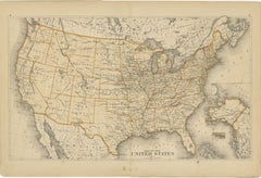
View AllUnited States Antique Map c.1888 – Railroads, Territories
State Stats
Located in Langweer, NL
Antique Map of the United States – Rand McNally, circa 1888
This antique map of the United States was published by Rand, McNally & Co. around 1888. It presents a colorful overview o...
Category
Antique Late 19th Century American Maps
Materials
Paper
1874 Map of the United States with Territorial Boundaries
Located in Langweer, NL
Title: 1874 Map of the United States with Territorial Boundaries
Description: This is an 1874 map titled "Map of the United States," showcasing the country during a period of rapid ...
Category
Antique 1870s Maps
Materials
Paper
$246 Sale Price
20% Off
1874 Map of Western United States – Detailed Atlas by Keith Johnston
Located in Langweer, NL
1874 Map of Western United States by Keith Johnston – Detailed Atlas
This is an original antique map titled “United States of North America (Western States)” by Alexander Keith John...
Category
Antique 1870s Scottish Maps
Materials
Paper

Antique Railroad Map of the United States by Rand, McNally
Co, 1900
Located in Langweer, NL
Antique map titled 'Rand, McNally & Co's New Official Railroad map of the United States with portions of The Dominion of Canada, The Republic of Mexico and the West Indies'. Large railroad map of the United States, sectionalised and laid on linen. Map shows state boundaries for the United States, Mexico, the West Indies, and lower portion of Canada; major cities and towns, military posts, Native American reservations, and railroads; Oklahoma and "Indian Territory." Inset: "Map of Alaska...
Category
20th Century Maps
Materials
Linen, Paper

$2,224 Sale Price
25% Off
Free Shipping
North America Antique Railroad Map c.1888 – U.S., Canada
Mexico
Located in Langweer, NL
Antique Map of North America – Rand McNally, circa 1888
This antique map of North America, published by Rand, McNally & Co. circa 1888, offers a comprehensive view of the continent ...
Category
Antique Late 19th Century American Maps
Materials
Paper
Map of Western United States 1903 – Railroads, State Borders, and Terrain
Located in Langweer, NL
Map of Western United States 1903 – Railroads, State Borders, and Terrain
This beautifully engraved map titled "United States of North America (Western Sheet)" was created by Keith ...
Category
Early 20th Century Maps
Materials
Paper

You May Also Like
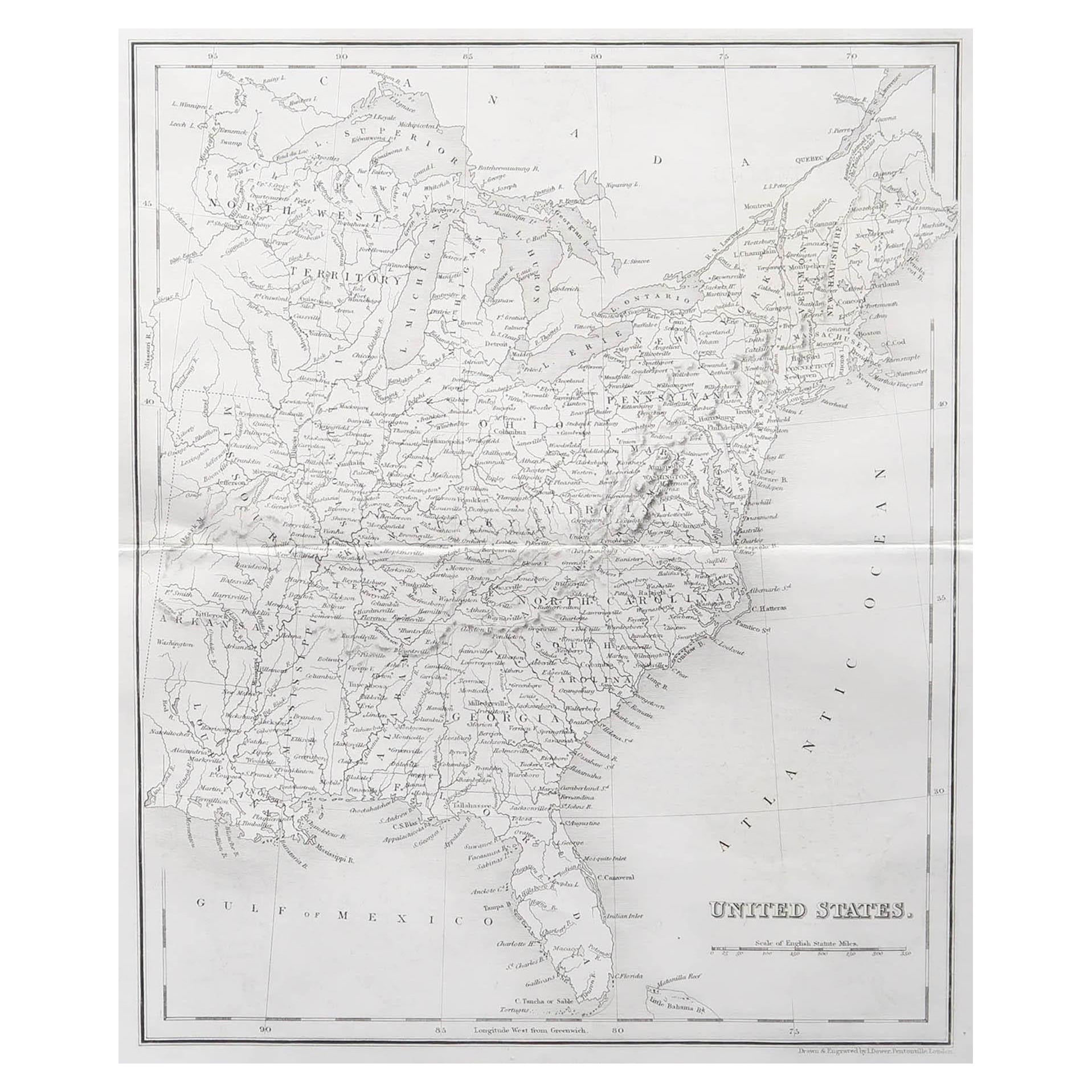
Original Antique Map of The United States of America by Dower, circa 1835
Located in St Annes, Lancashire
Nice map of the USA
Drawn and engraved by J.Dower
Published by Orr & Smith. C.1835
Unframed.
Free shipping
Category
Antique 1830s English Maps
Materials
Paper

1866 "Johnson
s United States" Map, Published by Johnson and Ward
Located in Colorado Springs, CO
Presented is a detailed map of the United States by A. J. Johnson. Spanning the whole of the continental United States, as well as adjacent parts of Canada and Mexico, the map reflec...
Category
Antique 1860s American Victorian Maps
Materials
Paper

Original Antique Map of United States, Grattan and Gilbert, 1843
Located in St Annes, Lancashire
Great map of United States
Drawn and engraved by Archer
Published by Grattan and Gilbert. 1843
Original colour
Unframed.
Category
Antique 1840s English Maps
Materials
Paper

Large Original Antique Map of the United States of America. 1891
By Rand McNally
Co.
Located in St Annes, Lancashire
Fabulous map of The United States
Original color
By Rand, McNally & Co.
Dated 1891
Unframed
Free shipping.
Category
Antique 1890s American Maps
Materials
Paper

1866 Ensign
Bridgman
s Rail Road Map of the United States
Located in Colorado Springs, CO
Presented is an 1866 issue of “Ensign & Bridgeman’s Rail Road Map of the United States, showing Depots & Stations.” First published in 1856, this is the third edition, following anot...
Category
Antique 1860s American Late Victorian Maps
Materials
Paper

1856 "Map of the United States" by Ensign, Bridgeman, and Fanning
Located in Colorado Springs, CO
Presented is a scarce American wall map of the United States and Mexico issued by Ensign, Bridgman, and Fanning in 1856. As the title suggests, the map covers all of the United State...
Category
Antique 1850s American Victorian Maps
Materials
Paper

More Ways To Browse
Stanley Antique
Railway Map
Goblets
Mid Century Modern Yellow Chair
Paulin Pierre
Used Pianos Pianos
18th Century Engravings
Antique Carved Wood Chair
Black Scandinavian Modern Dining Chairs
Dutch Mid Century Modern Table
Gold Modern Coffee Table
Iconic Modern Furniture
Japanese Metal
Midcentury Modern Gray Glass Vase
Round Glass Coffee Tables
Vintage Cave
18th Century Wood Side Tables
Antique Hand Carved Dining Room Sets