Want more images or videos?
Request additional images or videos from the seller
1 of 8
1877 "Geological and Geographical Atlas of Colorado" by F. V. Hayden
$7,500List Price
About the Item
- Dimensions:Height: 28.5 in (72.39 cm)Width: 21 in (53.34 cm)Depth: 2.5 in (6.35 cm)
- Materials and Techniques:
- Place of Origin:
- Period:
- Date of Manufacture:1877
- Condition:Wear consistent with age and use.
- Seller Location:Colorado Springs, CO
- Reference Number:Seller: BK03461stDibs: LU90979580283
About the Seller
4.9
Gold Seller
Premium sellers maintaining a 4.3+ rating and 24-hour response times
Established in 2010
1stDibs seller since 2011
471 sales on 1stDibs
Authenticity Guarantee
In the unlikely event there’s an issue with an item’s authenticity, contact us within 1 year for a full refund. DetailsMoney-Back Guarantee
If your item is not as described, is damaged in transit, or does not arrive, contact us within 7 days for a full refund. Details24-Hour Cancellation
You have a 24-hour grace period in which to reconsider your purchase, with no questions asked.Vetted Professional Sellers
Our world-class sellers must adhere to strict standards for service and quality, maintaining the integrity of our listings.Price-Match Guarantee
If you find that a seller listed the same item for a lower price elsewhere, we’ll match it.Trusted Global Delivery
Our best-in-class carrier network provides specialized shipping options worldwide, including custom delivery.You May Also Like
Two volumes: Geographical Atlas of Spain (…) and General Dictionary...
Located in Madrid, ES
Two volumes: Geographical Atlas of Spain (…) and General Dictionary of all Peoples. Editors Gaspar y Roig. Spain, Madrid, 1864 and 1862.
Two volumes framed in a similar way, with l...
Category
Antique 1860s Spanish Other Books
Materials
Other

$1,073 / set
H 10.63 in W 7.09 in D 1.97 in
Sotheby
s The Wardington Library, Important Atlases and Geographies, Part 1 A-K
Located in valatie, NY
Sotheby's: The Wardington Library, Important Atlases and Geographies. Part One: A-K., London, 18 October 2005. 1st Ed hardcover catalog with 244 lots photographed in color and fully ...
Category
Early 2000s English Books
Materials
Paper
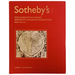
$49
H 11 in W 8.5 in D 1 in
National Geographic Atlas of the World, Eighth Edition Hardcover Book
Located in Moreno Valley, CA
National Geographic Atlas of the World, Eighth Edition
National Geographic
This is a beautiful large library or hardcover coffee table book.
Title: National Geographic Atlas of th...
Category
Early 2000s Maltese Mid-Century Modern Books
Materials
Paper
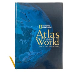
$165
H 18.5 in W 12.5 in D 1.25 in
Large Antique Map of Asia The Royal Atlas of Modern Geography by Johnston, 1882
Located in Langweer, NL
Antique map titled 'Asia'. Old map of the Asian continent. This map originates from 'The Royal Atlas of Modern Geography, Exhibiting, in a Series of Entirely Original and Authentic M...
Category
Antique 19th Century Maps
Materials
Paper
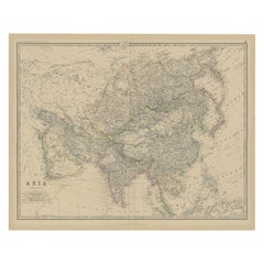
$345
H 19.53 in W 24.22 in D 0 in
Original 1859 Map of Asia from W.G. Blackie
s Imperial Atlas of Modern Geography
Located in Langweer, NL
Antique map titled 'Asia'. Original antique map of Asia. This map originates from ‘The Imperial Atlas of Modern Geography’. Published by W. G. Blackie, 1859.
The "Classic Cartograph...
Category
Antique Mid-19th Century Maps
Materials
Paper
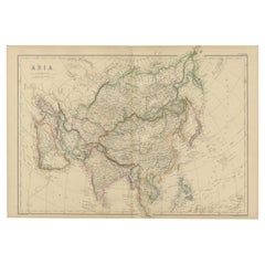
$238 Sale Price
20% Off
H 14.57 in W 21.26 in D 0.02 in
Antique Geological Map of the World by Johnston
1850
Located in Langweer, NL
Antique map titled 'The Geological Structure of the Globe'. Original antique geological map of the world. This map originates from 'The Physica...
Category
Antique Mid-19th Century Maps
Materials
Paper

$286 Sale Price
20% Off
H 11.03 in W 14.18 in D 0.02 in
Geographical Antique Map of Principality of Monaco
By Bruno Santini
Located in Alessandria, Piemonte
ST/609 - Interesting antique color map of Monaco Principality in French language : "Carte qui contient le Principauté de Piémont, le Monferrat et la comté de...
Category
Antique Late 18th Century Italian Other Maps
Materials
Paper

Antique Geographical, Historical and Statistical Map of Massachusetts, 1822
Located in Langweer, NL
This attractive map of Massachusetts presents a finely detailed overview of the state in the first quarter of the 19th century.
Transportation ...
Category
Antique 1820s Maps
Materials
Paper
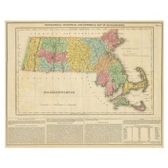
$362 Sale Price
20% Off
H 17.13 in W 21.46 in D 0 in
French Geographical, Statistical and Historical Map of Pensylvania, 1825
Located in Langweer, NL
Title: Carte geographique, statistique et historique de la Pensylvanie.
Beautiful Hand-Colored 1825 French Map of Pennsylvania, with a List of Prominent Rivers, Descriptions of Mountains, Climate and Government as well as a list of Colonial and post-American Revolution Governors
Produced by: J. Carez in Paris. (1825)
Hand colored engraved map. Relief shown by hachures. Text and tables at sides and bottom. Prime meridians: Washington and Paris.
A very interesting 1825 French hand-colored map of Pennsylvania from Lucas' 1822 map, which breaks down county populations by Whites and Free Blacks. "Carte Geographique, Statistique et Historique de la Pensylvanie" Originally published in 1822 by Carey and Lea and then revised and republished in 1825 by J. A. C. Buchon (1791-1846 ) in a French edition entitled Atlas Geographique des Deux Ameriques, printed by J. Carez. Fielding Lucas, Jr. (1781-1854), a Baltimore mapmaker and publisher, drew the map. original hand-coloring.
Shown on the map are parts of Maryland, Delaware, New York and New jersey. Printed on the same page as the map is geographical, statistical, and historical information about Pennsylvania, such as descriptions of the state's important rivers, a list of Governors since its founding as well as important French and Indian...
Category
Antique 1820s Maps
Materials
Paper
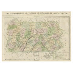
$457 Sale Price
20% Off
H 20.08 in W 25.99 in D 0 in
A New System of Modern Geography by William Guthrie - 1782
Located in Middletown, NY
A New System of Modern Geography; or, a Geographical, Historical, and Commercial Grammar; and Present State of the Kingdoms of the World. Maps engraved by Mr. Kitchin, C. Dilly and G...
Category
Antique Late 18th Century English Books
Materials
Gold Leaf
More From This Seller
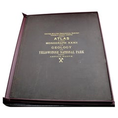
View All"Atlas to Accompany Monograph XXXII on the Geology of Yellowstone National Park"
By United States Geological Survey
Located in Colorado Springs, CO
This is an original 1904 "Atlas to Accompany Monograph XXXII on the Geology of the Yellowstone National Park" by Arnold Hague. Published by the Department of the Interior, the Atlas ...
Category
Antique Early 1900s American Maps
Materials
Leather, Fabric, Paper
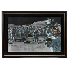
"Teammates in Mankind
s Greatest Adventure" Signed Poster by National Geographic
Located in Colorado Springs, CO
Presented is an original autographed poster from a 1973 issue of National Geographic magazine, celebrating the historic Apollo missions from the fir...
Category
Vintage 1970s American Mid-Century Modern Posters
Materials
Paper
1904 "Nell
s Topographical Map of the State of Colorado"
Located in Colorado Springs, CO
This highly detailed pocket map is a topographical map of the state of Colorado by Louis Nell from 1904. The map "has been compiled from all available...
Category
Antique Early 1900s American Maps
Materials
Leather, Paper

Report upon the Colorado River of the West by Joseph Ives, First Edition, 1861
Located in Colorado Springs, CO
Ives, Joseph Christmas. Report upon the Colorado River of the West. Washington: Government Printing Office, 1861. First Edition, Senate Issue. Extensively illustrated with maps, engr...
Category
Antique 1860s American Books
Materials
Fabric, Paper
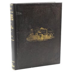
Atlas Shrugged by Ayn Rand, First Edition, First Printing, in Dust Jacket, 1957
By Ayn Rand
Located in Colorado Springs, CO
Rand, Ayn. Atlas Shrugged. New York: Random House, 1957. First edition, first printing. Thick octavo. In the publisher’s original first issue dust jacket, green cloth boards, stamped...
Category
Vintage 1950s American Mid-Century Modern Books
Materials
Leather, Fabric, Paper

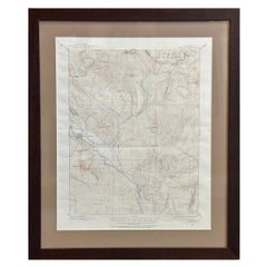
Vintage "Colorado, Crested Butte Sheet" USGS Topographical Map, 20th Century
By United States Geological Survey
Located in Colorado Springs, CO
Presented is a vintage "Colorado, Crested Butte Sheet" topographical map, first published by the United States Geological Survey. Highly detailed, the map captures the rugged topogra...
Category
20th Century American Maps
Materials
Paper
Still Thinking About These?
All Recently ViewedMore Ways To Browse
Blue Kilim Vintage
Contemporary Side Tables And Stools
Decorative Wall Plate
Mid Century Modern Corner Chair
Dining Tables With Brass Inlay
Oak Mid Century Armchair
Solid Wood Side Table Stool
Antique Marble Top Hall Table
Bird And Butterfly
Old Carpet
Porcelain Modern Hand Painted
Bent Plywood
1960 Italian Dining Set
Italian Giltwood Table
Polished Bronze Table
Antique Laurel Wreath
Armchair In France
Green Oushak