Want more images or videos?
Request additional images or videos from the seller
1 of 9
1896 "Territory of Arizona" Map, Published by the General Land Office
$2,750List Price
About the Item
- Dimensions:Height: 28.75 in (73.03 cm)Width: 25 in (63.5 cm)Depth: 1 in (2.54 cm)
- Materials and Techniques:
- Period:
- Date of Manufacture:1896
- Condition:Additions or alterations made to the original: Framed according to archival standards by Artem Art Services in Colorado Springs, CO. Wear consistent with age and use.
- Seller Location:Colorado Springs, CO
- Reference Number:Seller: M3921stDibs: LU909745349572
About the Seller
4.9
Gold Seller
Premium sellers maintaining a 4.3+ rating and 24-hour response times
Established in 2010
1stDibs seller since 2011
471 sales on 1stDibs
Authenticity Guarantee
In the unlikely event there’s an issue with an item’s authenticity, contact us within 1 year for a full refund. DetailsMoney-Back Guarantee
If your item is not as described, is damaged in transit, or does not arrive, contact us within 7 days for a full refund. Details24-Hour Cancellation
You have a 24-hour grace period in which to reconsider your purchase, with no questions asked.Vetted Professional Sellers
Our world-class sellers must adhere to strict standards for service and quality, maintaining the integrity of our listings.Price-Match Guarantee
If you find that a seller listed the same item for a lower price elsewhere, we’ll match it.Trusted Global Delivery
Our best-in-class carrier network provides specialized shipping options worldwide, including custom delivery.You May Also Like
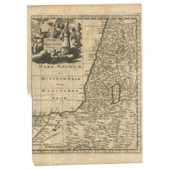
1750 Map of the Holy Land: The Land of Canaan and the Twelve Tribes
Located in Langweer, NL
Carte de la Terre de Canaan ou Terre Promise
Cartographer: Le St. Robert
Date of Publication: 1750
This exquisite 18th-century map, 'Carte de la Terre de Canaan ou Terre Promise', w...
Category
Antique 1750s French Maps
Materials
Paper

$1,916
H 20.6 in W 26.19 in D 0.01 in
Antique Map of the Holy Land, c.1717
Located in Langweer, NL
Antique map Israel titled 'Tabula Geographica Terrae Sanctae'. Rare edition made after a map of the Holy Land by J. Bonfrerius. The map is oriented ...
Category
Antique 18th Century Maps
Materials
Paper

Antique Map of the Holy Land, c.1710
Located in Langweer, NL
Antique map titled 'Totius Terrae Sanctae Delineatio'. Map of the Holy Land extending to Egypt and showing the route of the Children of Israel in their e...
Category
Antique 18th Century Maps
Materials
Paper
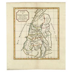
Antique Map of the Holy Land by Delamarche, 1806
By Charles Francois Delamarche
Located in Langweer, NL
Antique map titled 'Judee ou Terre Sainte sous les Turcs.' This map shows the holy land under the Turcs. By Robert de Vaugondy, revised and published by ...
Category
Antique 19th Century Maps
Materials
Paper
Antique Map of the Holy Land by Keur, 1748
Located in Langweer, NL
Antique Map Holy Land titled 'De Gelegentheyd van t'Paradys ende t'Landt Canaan, Mitsgaders d'eerst bewoonde Landen der Patriarchen'. Includes five decorative vignettes, including No...
Category
Antique 18th Century Maps
Materials
Paper

Antique Map of the Holy Land by Schut, 1710
Located in Langweer, NL
Antique map of the Holy Land titled 'Het Beloofde Landt Canaan.' Very detailed and decorative map of the Holy Land embellished with sailing ships and com...
Category
Antique 18th Century Maps
Materials
Paper

Antique Map of the Holy Land by Danckerts, c.1710
Located in Langweer, NL
Antique map titled 'Afbeeldinge van de Veertich-Iaarige Reyse der Kinderen Israëls uyt Egypten door de Roode Zee en de Woestyne tot in 't Beloofde Landt Canaan'. Map of the Holy Land...
Category
Antique 18th Century Maps
Materials
Paper

Adjutants of the Governor-General of the Dutch East Indies
1896
, 1900
Located in Langweer, NL
Antique print, titled: 'Adjudanten van den Gouveneur-Generaal 1896.' - This plate shows adjutants of the Governor-General of the Dutch East Indies in 1896.
Artists and Engravers: ...
Category
20th Century Prints
Materials
Paper
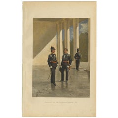
$119 Sale Price
20% Off
H 19.1 in W 12.2 in D 0.001 in
Map of the Dutchy of Holstein and the Territories of Hamburg
Lübek, 1875
Located in Langweer, NL
Title: Map of the Dutchy of Holstein and the Territories of Hamburg & Lübek by James Wyld, ca. 1875
Description: This is an antique map titled "A Map of the Dutchy of Holstein, with...
Category
Antique 1870s Maps
Materials
Paper
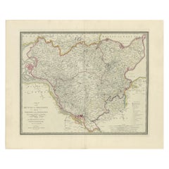
$900 Sale Price
20% Off
H 23.23 in W 28.35 in D 0.01 in
Territories of Antiquity: The Northern Division of Syria, A Detailed 1882 Map
Located in Langweer, NL
This 19th-century map from the atlas published by Blackie and Son in 1882 is titled "SYRIA (NORTH DIVISION)" and covers the northern part of Syria, capturing its geographical and adm...
Category
Antique 1880s English Maps
Materials
Paper

$268 Sale Price
20% Off
H 14.97 in W 11.03 in D 0 in
More From This Seller
View All1890 "Map of Oregon, Kansas, California, and the Territories" by S. A. Mitchell
By Samuel Augustus Mitchell 1
Located in Colorado Springs, CO
Presented is an 1890 map "Map of Oregon, Kansas, California, and the Territories" by S. A. Mitchell Jr. The map was issued in the atlas “Mitchell's New Intermediate Geography” publis...
Category
Antique 1890s American Victorian Maps
Materials
Paper

1840 Map of the City of Washington Published by William M. Morrison
Located in Colorado Springs, CO
This map, printed in 1840, is a detailed representation of Washington, D.C. in the mid-19th century. The map shows block numbers, wards, and government buildings as well as details o...
Category
Antique 1840s American Federal Maps
Materials
Paper

1842 Wall Map of the United States by J. H. Young, Published by S. A. Mitchell
Located in Colorado Springs, CO
Presented is an 1842 hanging “Map of the United States,” engraved by J. H. Young and published by Samuel Augustus Mitchell, Philadelphia. This is a beautiful example of the rare 1842...
Category
Antique 1840s American Maps
Materials
Paper

1870 "Johnson
s Europe" Map Published by A. J. Johnson
Located in Colorado Springs, CO
Presented is an original 1870 "Johnson’s Europe" map. First published in 1864, this map was issued as pages 87 and 88 in the 1870 edition of “Johnson's New Illustrated (Steel Plate) ...
Category
Antique 1870s American Victorian Maps
Materials
Paper

"Taylor and His Generals, " First Edition, Published by E. H. Butler
Co., 1847
Located in Colorado Springs, CO
Taylor and his Generals. New York: E.H. Butler & Co., 1847. First Edition. Rebound in quarter leather and marble paper boards. Housed in custom slipcase.
Presented is the 1847 First Edition of Taylor and His Generals. Published by E.H. Butler & Company, the book has numerous portraits and engravings throughout. It has been beautifully rebound in quarter leather and marble paper boards. The spine has gilt embossed decoration stating that it’s a first edition. The book is housed in a custom-built archival slipcase with a photo of Taylor on the front.
Written and published before Taylor ran for the Presidency, this book would have been a powerful propaganda tool for the soon-to-be 12th President of the United States. The full title page describes the work as “Taylor and His Generals; A Biography of Major-General Zachary Taylor; And Sketches of the Lives of Generals Worth, Wool, and Twiggs with a full account of the Actions of their Various Divisions in Mexico Up to the Present Time; Together with a Sketch of the Major-General Winfield Scott and an Account of his Divisions in Mexico.”
Taylor fought and commanded troops in the War of 1812, Black Hawk War, and the Second of the Seminole Wars before playing a major role in the victory of the Mexican-American War. The book takes the reader through the early life of Taylor and his military career with a particular focus on his surprising victory at the Battle of Buena Vista. Generals Worth, Wool, and Twiggs that served under Taylor and Major-General Scott each get a chapter dedicated to their own history and military careers
The Battle of Buena Vista took place in February of 1847 during the Mexican-American War. With only about 5,000 soldiers, Taylor repelled General Antonio Lopez de Santa Anna...
Category
Antique 1840s American Books
Materials
Paper

1866 "Johnson
s United States" Map, Published by Johnson and Ward
Located in Colorado Springs, CO
Presented is a detailed map of the United States by A. J. Johnson. Spanning the whole of the continental United States, as well as adjacent parts of Canada and Mexico, the map reflec...
Category
Antique 1860s American Victorian Maps
Materials
Paper

Still Thinking About These?
All Recently ViewedMore Ways To Browse
Antique Tombstone
Cream Soup
Early English Silver
Paisley Rugs and Carpets
Black And Chrome Lounge Chair
Vintage 1930 Dining Room Set
Antique Brass And Copper
Antique Cow
Antique Harvest
Antique Victorian Dining Tables
Environment Furniture
Italian Plastic Chairs
Made In Belgium
Black Crystal Glasses
French Mid Century Modern Rug
China Silk Rug
Chrome Glass Coffee Tables
Antique Italian Chairs