Items Similar to 18th-Century Map of the Eastern Roman Empire by Henri Chatelain, c. 1719

Want more images or videos?
Request additional images or videos from the seller
1 of 6
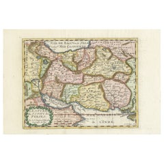
18th-Century Map of the Eastern Roman Empire by Henri Chatelain, c. 1719
$1,420.64
£1,061.32
€1,200
CA$1,978.16
A$2,125.43
CHF 1,140.29
MX$25,039.99
About the Item
Title: 18th-Century Map of the Eastern Roman Empire by Henri Chatelain, c. 1719
Description: This intricately detailed map, titled *Nouvelle Carte pour Servir à l'Histoire de l'Empire d'Orient depuis les Premiers Empereurs Romains...*, was created by Henri Chatelain around 1719. It portrays the Eastern Roman Empire, spanning the Mediterranean, Near East, and Central Asia, while including notable regions such as Scythia, Persia, Mesopotamia, and the Levant. This map was part of Chatelain’s monumental *Atlas Historique,* blending cartography with historical narrative.
The map is beautifully hand-colored and enriched with historical annotations and tables, explaining the territories and timelines of emperors, kingdoms, and conquests. Key locations, such as the Caspian Sea, the Pontus Euxinus (Black Sea), and the Arabian Peninsula, are carefully labeled, making this piece a fascinating exploration of historical geography. Its dual focus on geography and chronology appeals to both map collectors and history enthusiasts.
Condition report: The map is in almost excellent condition for its age, with vibrant hand-coloring and sharp engraving. Slight toning and minor foxing are present, particularly in the margins, but these do not detract from the overall clarity and appeal.
Framing tip: Use archival matting with UV-protective glass to preserve the map’s vibrant hand-coloring and paper integrity. A classic wooden frame, either natural or with gilded accents, will enhance its historical significance while providing an elegant display.
- Dimensions:Height: 21.66 in (55 cm)Width: 24.81 in (63 cm)Depth: 0.01 in (0.2 mm)
- Materials and Techniques:Paper,Engraved
- Period:1710-1719
- Date of Manufacture:circa 1719
- Condition:Condition report: The map is in very good condition for its age, with vibrant hand-coloring and sharp engraving. Slight toning and minor foxing are present, particularly in the margins, but these do not detract from the overall clarity and appeal.
- Seller Location:Langweer, NL
- Reference Number:Seller: BG-14043-71stDibs: LU3054343391762
About the Seller
5.0
Recognized Seller
These prestigious sellers are industry leaders and represent the highest echelon for item quality and design.
Platinum Seller
Premium sellers with a 4.7+ rating and 24-hour response times
Established in 2009
1stDibs seller since 2017
2,836 sales on 1stDibs
Typical response time: 1 hour
- ShippingRetrieving quote...Shipping from: Langweer, Netherlands
- Return Policy
More From This Seller
View AllOttoman Empire Map 1719 – Europe Asia Africa, Jean Chiquet, Paris
Located in Langweer, NL
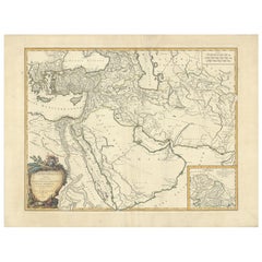
Title: Ottoman Empire Map 1719 – Europe Asia Africa, Jean Chiquet, Paris
Description:
Original early-18th-century engraved map titled Estats de l’Empire du Grand Seigneur, depicting the Ottoman Empire across three continents: Europe, Asia, and Africa. This example is clearly dated 1719 in the engraved cartouche and bears the publisher’s imprint Chez Jacq. Chiquet à Paris 1719.
The map presents the Ottoman Empire at an early Enlightenment moment, extending from Central and Southeastern Europe through Anatolia and the Levant, across Mesopotamia and Arabia, and into Egypt and the North African Barbary Coast. Political regions are defined by engraved boundaries and differentiated with original hand coloring, while coastlines, rivers, and seas are rendered with strong copper engraving typical of early 18th-century French map production.
French toponymy is dense and legible, with major cities and regions clearly identified, including Constantinople, Aleppo, Damascus, Baghdad, Cairo, Mecca, and Jerusalem. The Mediterranean, Black Sea, Red Sea, and Caspian Sea anchor the composition and emphasize the empire’s strategic maritime reach.
The decorative cartouche at upper right contains the full title and date, identifying the Ottoman ruler as “Grand Seigneur,” Sultan and Emperor of the Turks, ruling territories in Europe, Asia, and Africa. A lower table listing Ottoman rulers reinforces the political and didactic purpose of the map, which was intended both for geographic reference and informed private collecting.
Issued by Jean Chiquet, a Parisian map seller active in the early 18th century, this map reflects the commercial dissemination of authoritative geographic models during the reign of Louis XV. It combines political clarity with restrained decorative appeal, making it equally suitable for scholarly collections and interior display.
Condition report:
Copper engraving with original hand coloring. Age-related toning and light spotting consistent with an early 18th-century print. Minor edge wear and small handling marks, mainly in the margins. Plate mark visible. No major losses or repairs. Overall very good condition for a map dated 1719.
Framing tips:
Preserve the full margins and visible plate mark with a wide ivory or parchment-toned mat. A walnut, ebonized wood, or muted antique gold frame complements the period character. For a cleaner contemporary look, use a slim black frame with generous off-white matting.
SEO keyword block:
Ottoman Empire map 1719, antique Ottoman map, Jean Chiquet map, Middle East map 18th century, Holy Land map antique, Arabia map 1719, Turkey map...
Category
Antique Early 18th Century French Maps
Materials
Paper
Finely Engraved Historical Map of Middle East and Asia, c.1745
Located in Langweer, NL
Description: Antique map titled'Theatrum Historicum pars Orientalis.'
Finely engraved historical map with a profusion of details. It shows the Middle East and Asia. Decorative ti...
Category
Antique 1740s Maps
Materials
Paper

Highly Decorative Map of The Eastern Mediterranean and The Middle East, ca.1700
Located in Langweer, NL
Antique map titled 'Byzondere Kaart van de Landen Daar de Apostelen Het Evangelium Gepredikt Hebben (..).'
Highly decorative map of the eastern Mediterranean...
Category
Antique Early 1700s Maps
Materials
Paper
1742 Antique Map of the Persian Empire with Detailed Borders and Cartouche
Located in Langweer, NL
Title: 1742 Covens & Mortier Map of the Persian Empire by Guillaume De L'Isle
This remarkable 1742 map, "Carte de Perse," was originally designed by Guillaume De L'Isle, a preemin...
Category
Antique 1740s Dutch Maps
Materials
Paper
$1,534 Sale Price
20% Off
Map of the Persian Empire by Nicolas Sanson, Hand-colored, circa 1683
Located in Langweer, NL
Map of the Persian Empire by Nicolas Sanson, hand-colored, circa 1683
This finely detailed and delicately hand-colored map titled *L'Empire du Sophy des Perses* presents a late 17th...
Category
Antique 1680s Maps
Materials
Paper
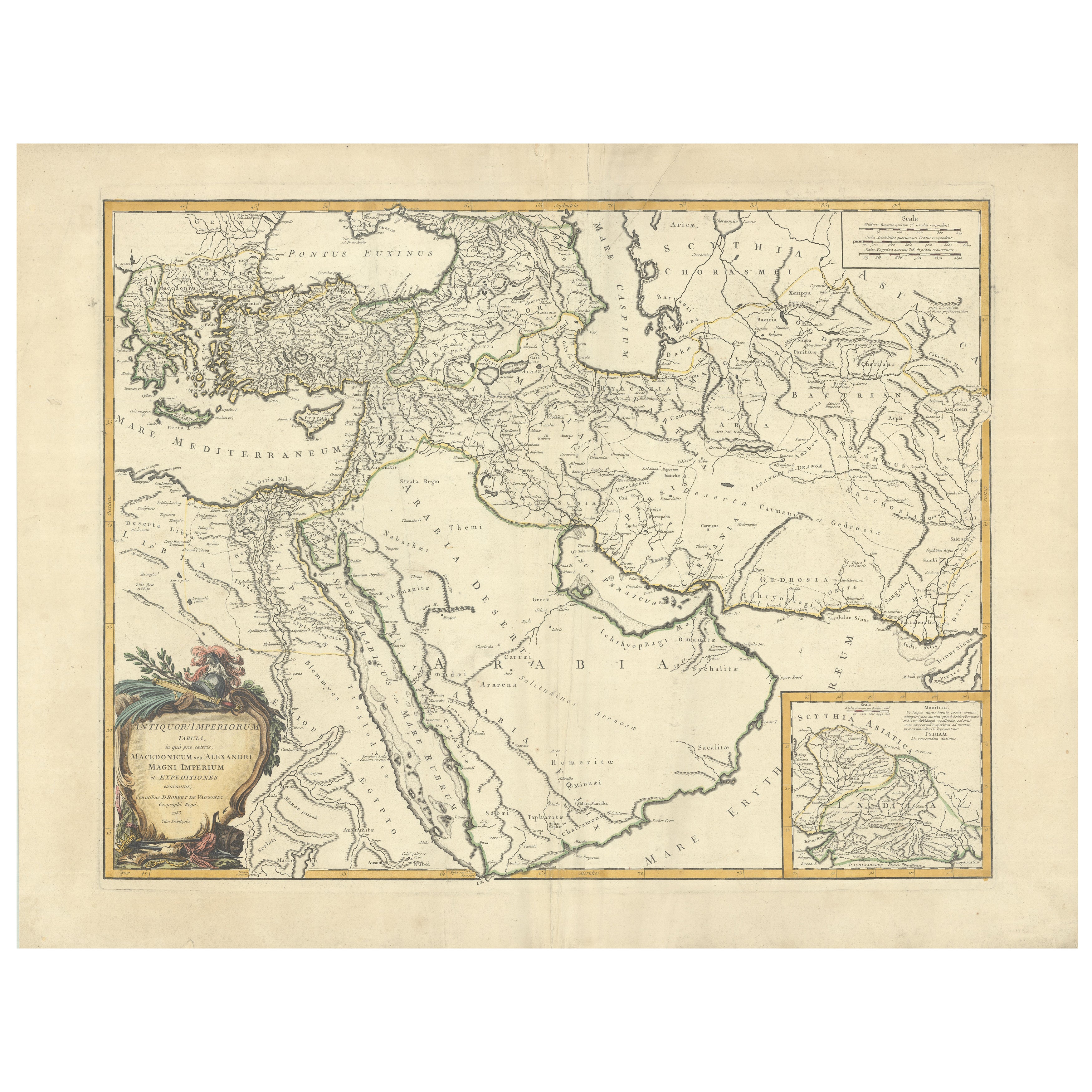
Antique Map of Alexander the Great
s Empire
Campaigns, de Vaugondy, 1753
Located in Langweer, NL
Antique Map of Alexander the Great's Empire & Campaigns, de Vaugondy, 1753
This rare and elegantly engraved map, titled "Antiquor Imperiorum Tabula, in qua Prae Caeteris, Macedonicu...
Category
Antique Mid-18th Century European Maps
Materials
Paper
You May Also Like
Southern
Eastern Europe: A Large 17th C. Hand-colored Map by Sanson
Jaillot
By Nicolas Sanson
Located in Alamo, CA
This large hand-colored map entitled "Estats de L'Empire des Turqs en Europe, ou sont les Beglerbeglicz our Gouvernements" was originally created by Nicholas Sanson d'Abbeville and t...
Category
Antique 1690s French Maps
Materials
Paper

Southern
Eastern Europe: A Large 17th C. Hand-colored Map by Sanson
Jaillot
By Nicholas Sanson d
Abbeville
Located in Alamo, CA
This large hand-colored map entitled "Estats de L'Empire des Turqs en Europe, ou sont les Beglerbeglicz our Gouvernements" was originally created by Nicholas Sanson d'Abbeville and this version was published by Hubert Jaillot in "Atlas Nouveau" in Paris in 1692. It depicts the territories of the Ottoman Empire in Europe, predominantly Eastern Europe. Highlights include, the Mediterranean Sea, the Adriatic Sea, the Black Sea, the Dalmation Coast including present day Croatia, Bosnia and Herzegovina, Montenegro, Serbia, Slovenia, Italy, Greece, North Macedonia, Turkey, Romania, Hungary, Albania, Kosovo, Bulgaria, Transylvania, Moldova and southern portions of France, Switzerland, Germany, and Poland..
The map consists of two sheets joined as one along a vertical joint. The map has original hand-coloring. It is printed on antique hand-made laid, chain-linked paper with wide margins. The sheet measures 24.88" high and 38" wide. There is a central vertical joint, as issued. The map is in very good condition.
Nicholas Sanson d'Abbeville (1600-1667) was one of the greatest French cartographather of French cartography. Sanson opened his first printing business in Paris in 1638. The king recognized his skill and knowledge and made him the official geographer to the court. He eventually served two kings in this capacity. Sanson was succeeded by his sons and son...
Category
1690s Landscape Prints
Materials
Engraving

18th Century Map of the Southern Balkans by Giovanni Maria Cassini
By Giovanni Maria Cassini
Located in Hamilton, Ontario
18th century map by Italian engraver Giovanni Maria Cassini (Italy 1745-1824).
Map of the Southern Balkans: Rome. Hand colored and copper engraved print done in the year 1788. It in...
Category
Antique 18th Century Italian Maps
Materials
Paper

$795 Sale Price
36% Off
Hand-Colored 18th Century Homann Map of the Black Sea, Turkey and Asia Minor
By Johann Baptist Homann
Located in Alamo, CA
An attractive original early 18th century hand-colored map of the Black Sea and Turkey entitled "Carte de L'Asie Minevre ou de la Natolie et du Pont Evxin Tiree des Voyages et des Ob...
Category
Antique Early 18th Century German Maps
Materials
Paper

Southern Greece: A Large 17th Century Hand-colored Map By Sanson and Jaillot
By Nicholas Sanson d
Abbeville
Located in Alamo, CA
This large original hand-colored copperplate engraved map of southern Greece and the Pelopponese Peninsula entitled "La Moree Et Les Isles De Zante, Cefalonie, Ste. Marie, Cerigo & C...
Category
1690s Landscape Prints
Materials
Engraving

17th Century Nicolas Visscher Map of Southeastern Europe
Located in Hamilton, Ontario
A beautiful, highly detailed map of southeastern Europe by Nicolas Visscher. Includes regions of Northern Italy (showing the cities Bologna, Padua, and Venice), Bohemia, Austria (sho...
Category
Antique 17th Century Dutch Maps
Materials
Paper

$1,350 Sale Price
38% Off
More Ways To Browse
Blue Green Wool And Silk Rug
Brown Sheepskin Chair
Vintage Brass Bar Carts
Antique Botanical Prints
Green Persian Rug
50 X 50 Coffee Table
Milo Baughman 1970
Spanish Baroque Furniture
Stone China
Couch Console
Vintage Burn
Chinese Stone
Sterling Silver Flatware Service For 12
Antique Dining Tables With Leaves
Decorative Wall Panels
Frank Lloyd Wright For Cassina
Natural Curved
Spanish Wool Rug