Items Similar to 18th Century Map of the Southern Balkans by Giovanni Maria Cassini

Want more images or videos?
Request additional images or videos from the seller
1 of 6
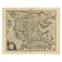
18th Century Map of the Southern Balkans by Giovanni Maria Cassini
$795
$1,25036% Off
£602.14
£946.7636% Off
€691.54
€1,087.3236% Off
CA$1,114.05
CA$1,751.6636% Off
A$1,211.20
A$1,904.4136% Off
CHF 642.18
CHF 1,009.7236% Off
MX$14,519.25
MX$22,82936% Off
NOK 8,161.79
NOK 12,83336% Off
SEK 7,477.31
SEK 11,756.7836% Off
DKK 5,168.35
DKK 8,126.3436% Off
About the Item
18th century map by Italian engraver Giovanni Maria Cassini (Italy 1745-1824).
Map of the Southern Balkans: Rome. Hand colored and copper engraved print done in the year 1788. It includes Macedonia and Albania, with parts of Serbia, Croatia, Bulgaria, and Romania. Decorative cartouche with title to the left. Mounted on board.
Title: "L’Albania e la Macdeonia con porzione della Dalma Zia Servia Vallachia Bulgaria e Romania. 111. Folgio della Carta generale dell’ Ungheria e della Turchia Europea in Roma. Presso la Caleograsia Camerale, 1788.”
Map size: 19.5" 14.5"
Mat size: 25.5" x 20.75".
- Creator:Giovanni Maria Cassini (Maker)
- Dimensions:Height: 20.75 in (52.71 cm)Width: 25.5 in (64.77 cm)Depth: 0.1 in (2.54 mm)
- Materials and Techniques:
- Place of Origin:
- Period:
- Date of Manufacture:1788
- Condition:Wear consistent with age and use. Selling with the matting but should be re-matted as it has some wear.
- Seller Location:Hamilton, CA
- Reference Number:1stDibs: LU1355214145721
About the Seller
5.0
Platinum Seller
Premium sellers with a 4.7+ rating and 24-hour response times
Established in 2010
1stDibs seller since 2015
1,365 sales on 1stDibs
Typical response time: 5 hours
- ShippingRetrieving quote...Shipping from: Hamilton, Canada
- Return Policy
More From This Seller
View All17th Century Nicolas Visscher Map of Southeastern Europe
Located in Hamilton, Ontario
A beautiful, highly detailed map of southeastern Europe by Nicolas Visscher. Includes regions of Northern Italy (showing the cities Bologna, Padua, and Venice), Bohemia, Austria (sho...
Category
Antique 17th Century Dutch Maps
Materials
Paper

$1,350 Sale Price
38% Off
Map of the Kingdom of Sardinia and Part of the Kingdom of Genoa, Rome
By Giovanni Maria Cassini
Located in Hamilton, Ontario
18th century map by Italian engraver Giovanni Maria Cassini (Italy 1745-1824). Map of Part of the Kingdom of Sardinia and Part of the Kingdom of Genoa: Rome. This is a hand colored a...
Category
Antique 18th Century Italian Maps
Materials
Paper

$795 Sale Price
36% Off
Early 19th Century Hand Colored Map of the United States and Caribbean Islands
Located in Hamilton, Ontario
Hand coloured early 19th century map by Giraldon of France titled "Etats Unis et Grandes Antilles" (United States and Greater Antilles).
Category
Antique Early 19th Century French Maps
Materials
Paper

$595 Sale Price
40% Off
Early 19th Century Hand Coloured Map of North America by Aaron Arrowsmith
By Aaron Arrowsmith
Located in Hamilton, Ontario
Hand coloured map in French by English cartographer Aaron Arrowsmith (1750–1823) titled "Amerique Septentionale" (North America).
Map size: 9.5" x 8"
Mat size: 20.5" x 14.25".
Category
Antique Early 19th Century English Maps
Materials
Paper

$795 Sale Price
36% Off
Antique 1798 James Colnett A Voyage to the South Atlantic
Round Cape Hope Book
Located in Hamilton, Ontario
This antique book titled "A Voyage to the South Atlantic and Round Cape Horn into the Pacific Ocean", and authored by W. Bennett, on the work of James Colnet...
Category
Antique Late 18th Century English Georgian Books
Materials
Leather, Paper
Mariner
s Chart Poster
Located in Hamilton, Ontario
Mariner's chart poster (nautical).
Category
20th Century Posters
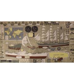
$1,795 Sale Price
20% Off
You May Also Like
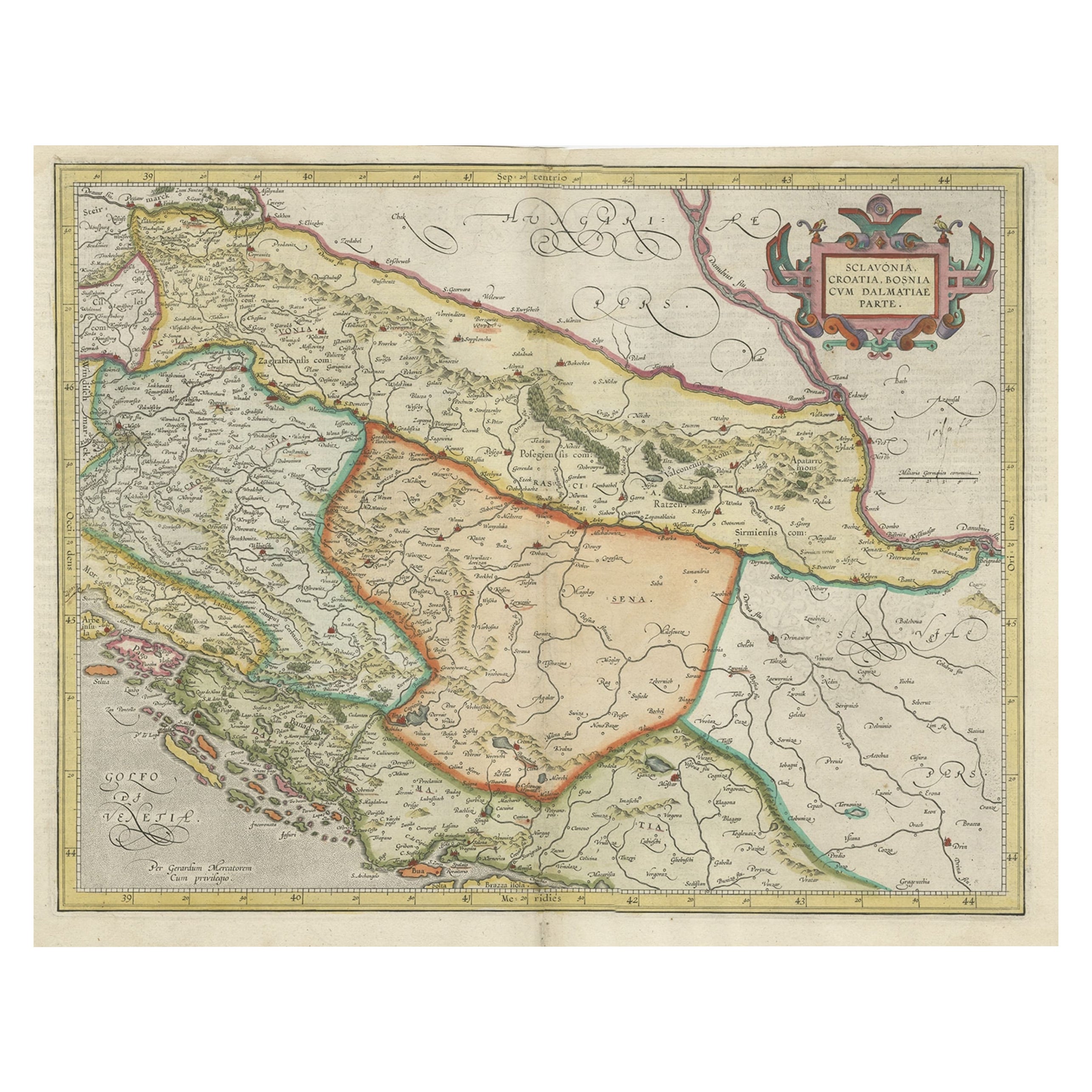
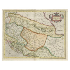
Old Eastern Balkans Map, with Dalmatia, Croatia, Slavonia, Bosnia, Serbia, 1633
Located in Langweer, NL
Antique map titled 'Sclavonia, Croatia, Bosnia cum Dalmatiae Parte'. Old map of the Eastern Balkans with the geographical & political divisions of Dalmatia, Croatia, Slavonia, Bosnia, Serbia, etc. The map details the course of the Danube, Sauus, and Drauus Rivers. Originates from the 1633 German edition of the Mercator-Hondius Atlas Major, published by Henricus Hondius and Jan Jansson under the title: 'Atlas: das ist Abbildung der gantzen Welt, mit allen darin begriffenen Laendern und Provintzen: sonderlich von Teutschland, Franckreich, Niderland, Ost und West Indien: mit Beschreibung der selben.'
Artists and Engravers: Gerard Mercator (1512 - 1594) originally a student of philosophy was one of the most renowned cosmographers and geographers of the 16th century, as well as an accomplished scientific instrument maker. He is most famous for introducing Mercators Projection, a system which allowed navigators to plot the same constant compass bearing on a flat map...
Category
Antique 1630s Maps
Materials
Paper
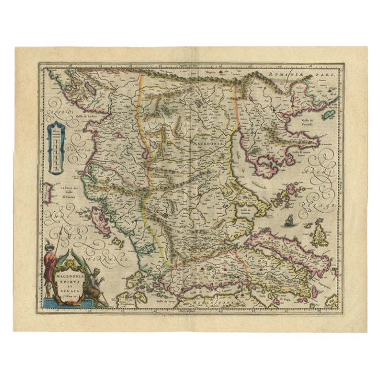
Antique Map of Macedonia by the Famous Mapmaker Blaeu, c.1650
Located in Langweer, NL
Antique map titled 'Macedonia, Epirus et Achaia'.
Ornated with a nice allegoric cartouche, one ship and a milage scale. Macedonia is shown in the centre of the map. With many detai...
Category
Antique 17th Century Maps
Materials
Paper
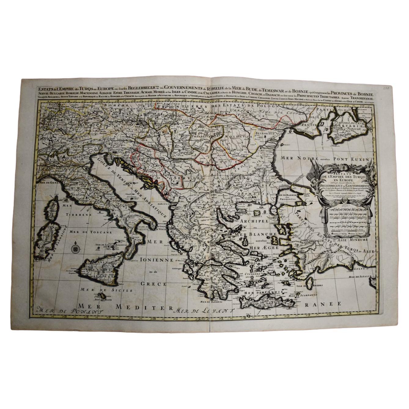
Southern
Eastern Europe: A Large 17th C. Hand-colored Map by Sanson
Jaillot
By Nicolas Sanson
Located in Alamo, CA
This large hand-colored map entitled "Estats de L'Empire des Turqs en Europe, ou sont les Beglerbeglicz our Gouvernements" was originally created by Nicholas Sanson d'Abbeville and t...
Category
Antique 1690s French Maps
Materials
Paper

$1,740 Sale Price
20% Off
Antique Map of Greece, Albania, Macedonia and Parts of Turkey and Cyprus, c.1745
Located in Langweer, NL
Antique map titled 'Accurata Totius Archipelagi Et Graeciae Universae Tabula'.
Detailed map of Greece. Includes Albania, Macedonia and parts of Turkey and Cyprus. With compass rose...
Category
Antique 18th Century Maps
Materials
Paper

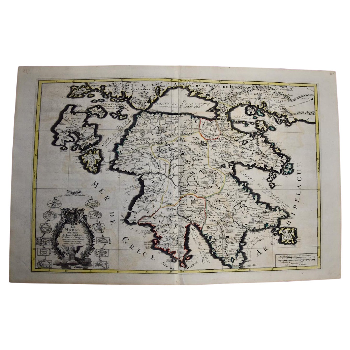
Southern Greece: A Large 17th C. Hand-colored Map by Sanson and Jaillot
By Nicolas Sanson
Located in Alamo, CA
This large original hand-colored copperplate engraved map of southern Greece and the Pelopponese Peninsula entitled "La Moree Et Les Isles De Zante, Cefalonie, Ste. Marie, Cerigo & C...
Category
Antique 1690s French Maps
Materials
Paper

$1,580 Sale Price
20% Off
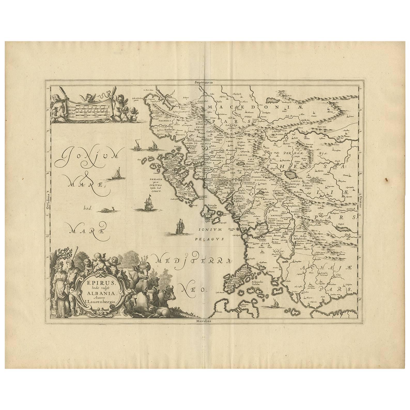
Antique Map of Epirus
Albania, Greece
by J. Janssonius, circa 1650
Located in Langweer, NL
This map covers the northwestern coast of Greece and part of present-day Albania. The map was drawn by Johannes Wilhelm Laurenberg, a mathematician and historian who produced several...
Category
Antique Mid-17th Century Dutch Maps
Materials
Paper
More Ways To Browse
Antique Maps Of Italy
Antique Macedonia
Albanian Antique
Maps Balkans
Antique English Maps
Indonesia Map
Ancient Maps
Antique Mining
Antique Atlas Furniture
Antique Maps Indonesia
Map Of India
China Map
Victorian Furniture 1920
Antique Maps Amsterdam
Antique Maps Of Russia
19th Century Map Of Africa
Map Of Britain
Antique Oregon