Items Similar to 18th Century Original Dutch Map of Martinique in The West Indies by Isaak Tirion


Want more images or videos?
Request additional images or videos from the seller
1 of 8
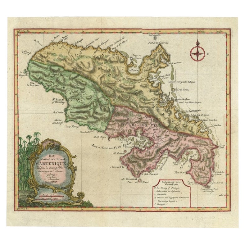
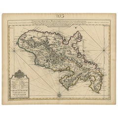
18th Century Original Dutch Map of Martinique in The West Indies by Isaak Tirion
$417.67
$522.0920% Off
£311.81
£389.7620% Off
€352
€44020% Off
CA$580.27
CA$725.3320% Off
A$624.16
A$780.2020% Off
CHF 333.57
CHF 416.9620% Off
MX$7,357.07
MX$9,196.3420% Off
NOK 4,205.53
NOK 5,256.9120% Off
SEK 3,844.65
SEK 4,805.8120% Off
DKK 2,682.64
DKK 3,353.2920% Off
About the Item
This is an 18th-century Dutch map of Martinique, titled *Het Westindisch Eiland Martinique*. The map was produced by Isaak Tirion, a renowned Dutch cartographer and publisher known for his precise and beautifully crafted maps. The cartouche in the lower left corner, adorned with decorative elements, adds to the aesthetic appeal of the map.
### Key Features:
- Martinique: The map offers detailed topographical information of the island, including mountains, rivers, and settlements.
- Geographical Details: Locations such as Fort Royal, Bay de St. Pierre, and Point de Cloche are marked, showcasing significant features of the island.
- Cartouche: The ornate cartouche, featuring tropical plants, reflects the importance of the island's agricultural production during the colonial period, particularly its sugar plantations.
This map captures Martinique during its time as a French colony and provides valuable insight into the island’s layout and strategic significance in the Caribbean. The attention to coastal detail highlights the importance of Martinique as a hub of maritime activity.
The map’s combination of aesthetic elegance and cartographic precision makes it a remarkable piece for collectors and those interested in Caribbean colonial history.
- Dimensions:Height: 16.15 in (41 cm)Width: 19.3 in (49 cm)Depth: 0 in (0.02 mm)
- Materials and Techniques:Paper,Engraved
- Period:1760-1769
- Date of Manufacture:1765
- Condition:Condition: good, given age. General age-related toning and/or occasional minor defects from handling. Creasing around the borders, not disturbing the image. Please study scans carefully.
- Seller Location:Langweer, NL
- Reference Number:Seller: BG-13618-21stDibs: LU3054341731142
About the Seller
5.0
Recognized Seller
These prestigious sellers are industry leaders and represent the highest echelon for item quality and design.
Platinum Seller
Premium sellers with a 4.7+ rating and 24-hour response times
Established in 2009
1stDibs seller since 2017
2,836 sales on 1stDibs
Typical response time: 1 hour
- ShippingRetrieving quote...Shipping from: Langweer, Netherlands
- Return Policy
More From This Seller
View AllAntique Map of Martinique, Showing Roads, Houses, Sugar Plantations, etc. c.1750
Located in Langweer, NL
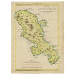
Antique map titled 'Carte de l'Isle de la Martinique'.
Detailed map of Martinique. Shows hilly terrain, forests, roads, houses, and even the sugar plantations. The island was to ...
Category
Antique 18th Century Maps
Materials
Paper
Antique Map of Martinique with Title Cartouche Garnished with Sugar Cane, c.1760
Located in Langweer, NL
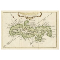
Antique map titled 'Het Westindisch Eiland Martenique'. Decorative map of Martinique filled with good detail of roads, topography, soundings, villages, windmills, and plantations. Th...
Category
Antique 18th Century Maps
Materials
Paper

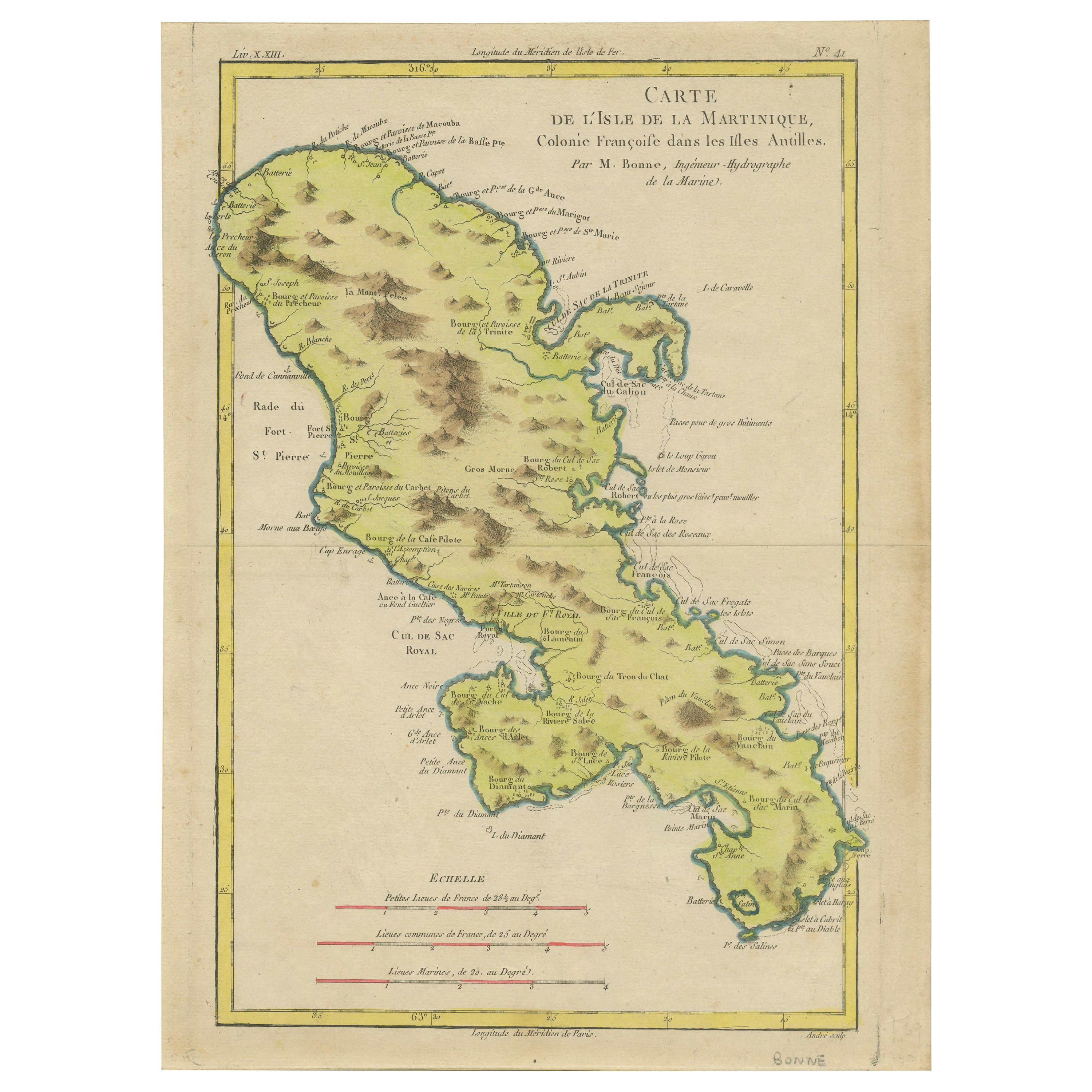
Antique Map of Martinique by Rigobert Bonne, Circa 1780
Located in Langweer, NL
Antique map titled 'Carte de l'Isle de la Martinique Colonie Francoise dans les Isles Antilles'. Detailed map of the French Island of Martinique.
Many towns and harbours, anchor pl...
Category
Antique 18th Century French Maps
Materials
Paper
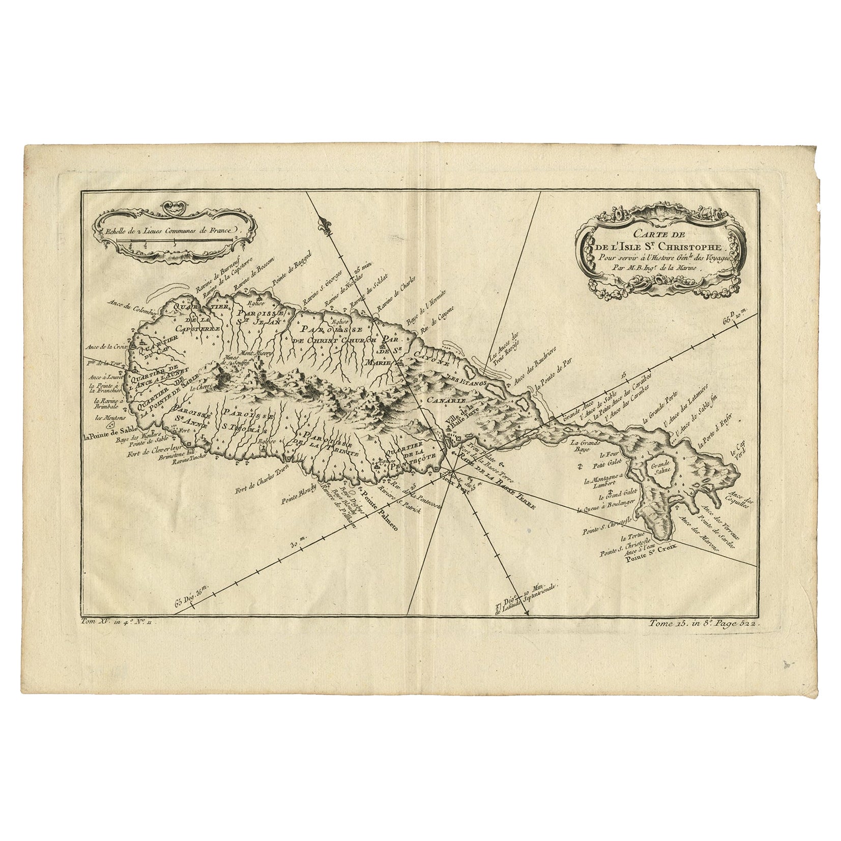
Antique Map of the Caribbean Island of St Kitts, ca.1750
Located in Langweer, NL
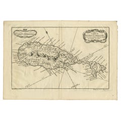
Description: Antique map titled 'Carte de l'Isle St. Christophe pour Servir a l'Histoire Genle. des Voyages.'
Detailed map of the Island of St. Kitts, showing the Parishes, towns, ...
Category
Antique 1750s Maps
Materials
Paper
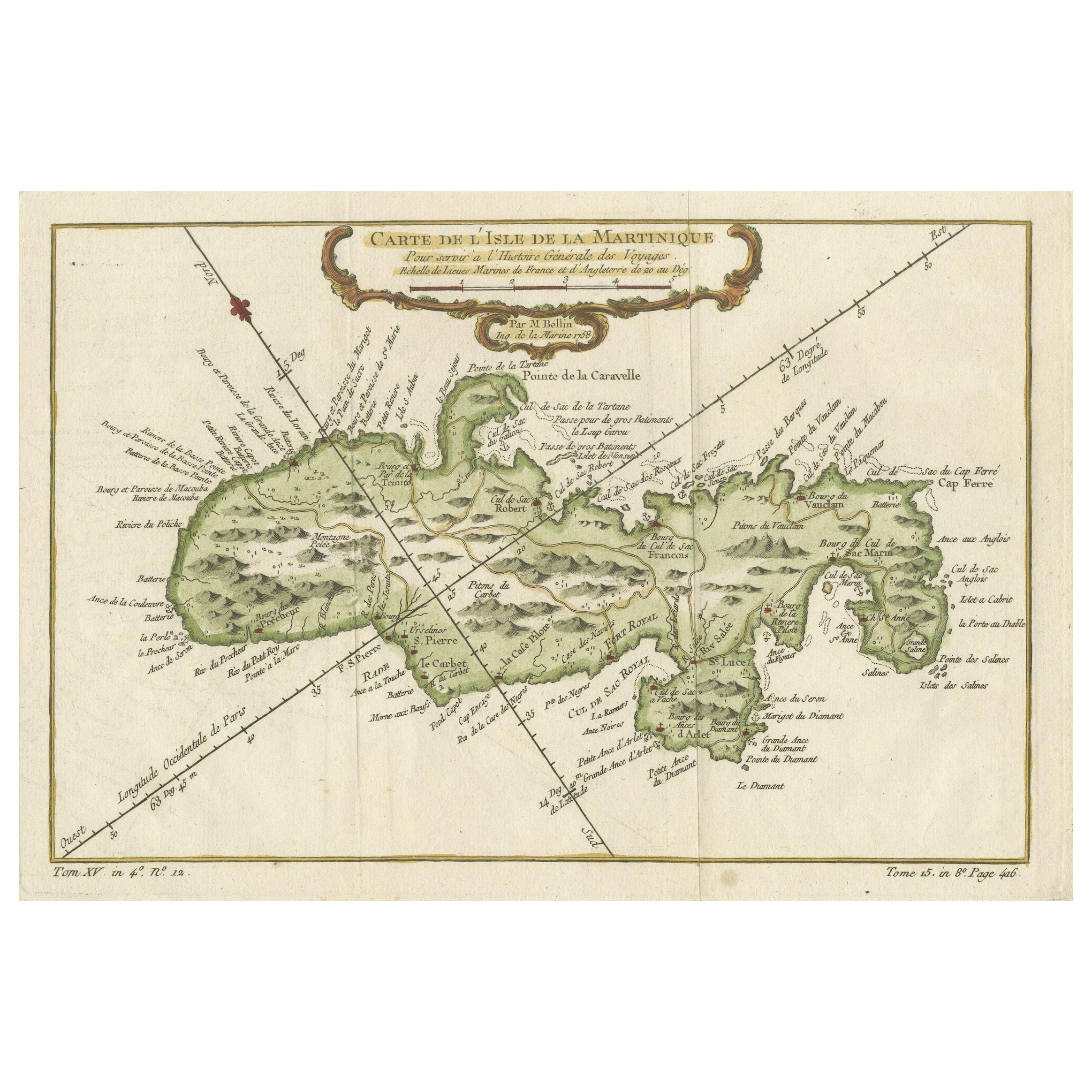
Martinique Island in the Caribbean by Bellin Original Original Antique Map, 1780
Located in Langweer, NL
This mid-18th century map, "Carte de l'Isle de la Martinique pour servir a l'historie generale des voyages," was issued in 1780 by M. Bellin in Paris. It presents a detailed and visually captivating depiction of the Island of Martinique within the context of the Caribbean and the Lesser Antilles.
**Title:** Carte de l'Isle de la Martinique pour servir a l'historie generale des voyages
**Issuer:** M. Bellin
**Date:** 1780
**Location Coverage:** North America, Caribbean, Martinique, Lesser Antilles
This engraved map is notable for its pleasing aesthetics, featuring lovely hand coloring that enhances its visual appeal. The inclusion of a scroll cartouche, an ornamental frame, and measurement lines adds a distinctive and visually appealing quality to the map.
Martinique, situated within the Lesser Antilles in the Caribbean, is presented with meticulous detail, showcasing geographical features, coastlines, settlements, and other notable landmarks. Bellin, known for his accuracy in cartography, crafted this map to serve as a geographical reference within the broader context of historical voyages and exploration.
The combination of detailed cartographic information and artistic embellishments, such as hand coloring and decorative elements, makes this map not only a valuable geographical document but also a visually pleasing piece of cartographic art...
Category
Antique Late 18th Century Maps
Materials
Paper
$265 Sale Price
20% Off
Antique Map of Guadeloupe, Island in the Caribbean, c.1757
Located in Langweer, NL
Antique map titled 'Carte de L'Isle de la Guadeloupe'.
A very decorative map of Guadeloupe in the Caribbean, adorned with rhumb lines, fleur-de-lys, and two decorative rococo-style...
Category
Antique 18th Century Maps
Materials
Paper

You May Also Like
St. Christophe
St. Kitts
Island: An 18th Century Hand-colored Map by Bellin
By Jacques-Nicolas Bellin
Located in Alamo, CA
Jacques Bellin's copper-plate map of the Caribbean island of Saint Kitts entitled "Carte De De l'Isle St. Christophe Pour servir á l'Histoire Genle. des V...
Category
Antique Mid-18th Century French Maps
Materials
Paper

West Coast of Africa, Guinea
Sierra Leone: An 18th Century Map by Bellin
By Jacques-Nicolas Bellin
Located in Alamo, CA
Jacques Bellin's copper-plate map entitled "Partie de la Coste de Guinee Dupuis la Riviere de Sierra Leona Jusquau Cap das Palmas", depicting the coast of Guinea and Sierra Leone in ...
Category
Antique Mid-18th Century French Maps
Materials
Paper

Map Of The Island Of Cuba - Guillaume Thomas Raynal (1711-1796)
Located in Porto, PT
This historical map of the Island of Cuba was produced in the late 18th century and is taken from an edition of “Atlas de toutes les parties connues du globe terrestre” by the French...
Category
Antique 18th Century Prints
Materials
Glass, Paper

St. Christophe (St. Kitts): Bellin 18th Century Hand Colored Map
Located in Alamo, CA
Jacques Bellin's copper-plate map of the Caribbean island of Saint Kitts entitled "Carte De De l'Isle St. Christophe Pour servir á l'Histoire Genle. des V...
Category
1740s Other Art Style Landscape Prints
Materials
Engraving

Map Colonies Francaises Martinique, 1845
Located in BUNGAY, SUFFOLK
Colonies Francaises, Martinique, Amerique DU SUD
Geographie et Statistique par V.Levasseur. Ing'r Geographe.
Illustre par Raymond Bonheur, peintre.
Grave par Laguihermie, Rue St...
Category
Antique 19th Century French Maps
Materials
Paper

Antique Jamaica Map, English, Caribbean, Cartography, Thomas Jefferys, Georgian
Located in Hele, Devon, GB
This is an antique Jamaica map. An English, framed Caribbean island engraving by Thomas Jefferys, dating to the 18th century and later, dated 1794.
Excellent Georgian period cartog...
Category
Antique 1790s British Georgian Maps
Materials
Glass, Paper

More Ways To Browse
Antique Cloche
Black Scandinavian Modern Dining Chairs
Gold Modern Coffee Table
Round Glass Coffee Tables
18th Century Wood Side Tables
Antique Hand Carved Dining Room Sets
Mid Century Modern Pitcher
Vintage Italian Leather Dining Chair
Vintage Movie Posters
Blue Green Wool And Silk Rug
Brown Sheepskin Chair
Vintage Brass Bar Carts
Antique Botanical Prints
Green Persian Rug
17th Century Blue And White
50 X 50 Coffee Table
Antique Wood Panel Painted
Milo Baughman 1970