Items Similar to 18th Century Portugal Original Antique Engraving by Bowles

Want more images or videos?
Request additional images or videos from the seller
1 of 5
18th Century Portugal Original Antique Engraving by Bowles
$425.14
$531.4320% Off
£317.67
£397.0920% Off
€356
€44520% Off
CA$586.42
CA$733.0220% Off
A$642.40
A$80320% Off
CHF 338.14
CHF 422.6720% Off
MX$7,667.24
MX$9,584.0620% Off
NOK 4,310.38
NOK 5,387.9720% Off
SEK 3,940.33
SEK 4,925.4220% Off
DKK 2,712.44
DKK 3,390.5520% Off
About the Item
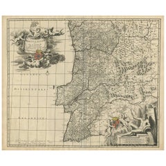
Antique map titled 'Bowles's New Pocket Map of Portugal, Laid Down According to the Sr. Nolin'. Large and detailed map of Portugal. With nice vignette, compass rose, key and scale. Artists and Engravers: Made by 'Thomas
Carington Bowles' after 'Nolin'. Thomas Bowles, born around 1712, was map publisher and seller in London. The business was continued by John and Carrington Bowles and finally under the name Bowles and Carver until early 19th century. Thomas died in 1767.
Artist: Made by 'Thomas
Carington Bowles' after 'Nolin'. Thomas Bowles, born around 1712, was map publisher and seller in London. The business was continued by John and Carrington Bowles and finally under the name Bowles and Carver until early 19th century. Thomas died in 1767.
Antique prints have long been appreciated for both their aesthetic and investment value. They were the product of engraved, etched or lithographed plates. These plates were handmade out of wood or metal, which required an incredible level of skill, patience and craftsmanship. Whether you have a house with Victorian furniture or more contemporary decor an old engraving can enhance your living space.
- Dimensions:Height: 26.78 in (68 cm)Width: 20.71 in (52.6 cm)Depth: 0 in (0.01 mm)
- Materials and Techniques:
- Period:
- Date of Manufacture:circa 1780
- Condition:Condition: Good, given age. Spotted top and bottom near plate edge and margins. Original middle fold as issued. General age-related toning and/or occasional minor defects from handling. Original/contemporary hand coloring, blank verso.
- Seller Location:Langweer, NL
- Reference Number:Seller: PC-589381stDibs: LU3054327616392
About the Seller
5.0
Recognized Seller
These prestigious sellers are industry leaders and represent the highest echelon for item quality and design.
Platinum Seller
Premium sellers with a 4.7+ rating and 24-hour response times
Established in 2009
1stDibs seller since 2017
2,809 sales on 1stDibs
Typical response time: 1 hour
- ShippingRetrieving quote...Shipping from: Langweer, Netherlands
- Return Policy
More From This Seller
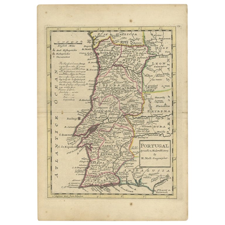
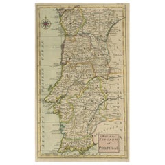
View AllAntique Map of Portugal by Moll, 1727
Located in Langweer, NL
Antique map Portugal titled 'Portugal Agreeable to Modern History'. Detailed map of Portugal showing major routes, waterways, arch bishoprics, bis...
Category
Antique 18th Century Maps
Materials
Paper
$189 Sale Price
20% Off
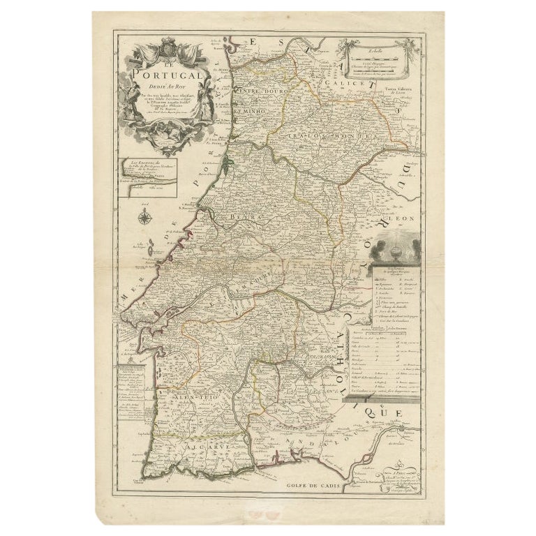
Antique Map of Portugal by Placide, c.1700
Located in Langweer, NL
Antique map titled 'Le Portugal dedié au Roy (..)'. Large and detailed map of Portugal. With a small inset map of Porto. Artists and Engravers: Publish...
Category
Antique 18th Century Maps
Materials
Paper
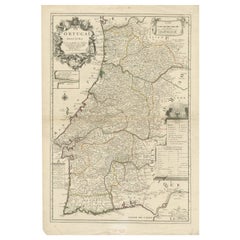
$377 Sale Price
20% Off
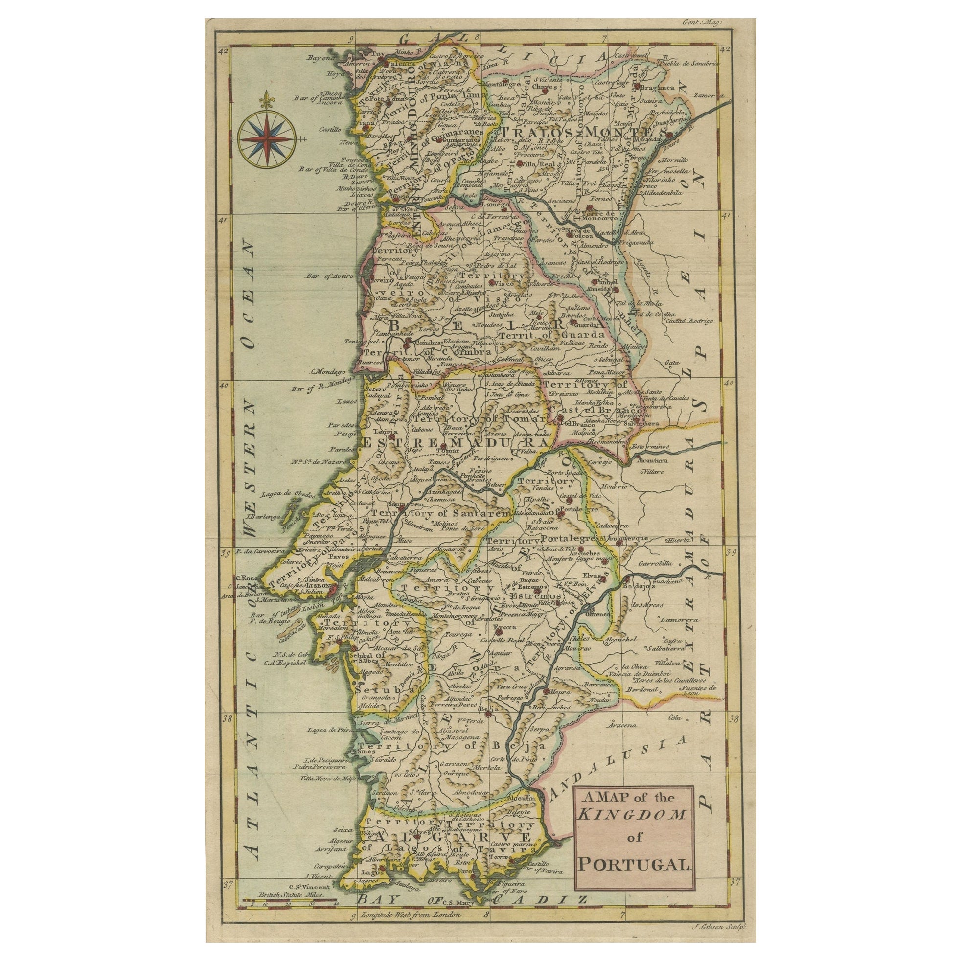
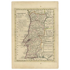
Detailed Antique Map of Portugal, Published for the
Gentleman
s Magazine
, 1758
Located in Langweer, NL
Antique map Portugal titled 'A Map of the Kingdom of Portugal'.
Detailed map of Portugal, published for the 'Gentleman's Magazine'.
Artist...
Category
Antique 1750s Maps
Materials
Paper
$458 Sale Price
20% Off
Antique Map of Portugal by P. Schenk, circa 1700
Located in Langweer, NL
Antique map titled 'Portugalliae et Algarbia'. Striking example of Schenk's rare map of Portugal, with the coats of arms of Portugal, Algarbia and a Spanish sailing vessell in the ca...
Category
Antique Early 18th Century Maps
Materials
Paper

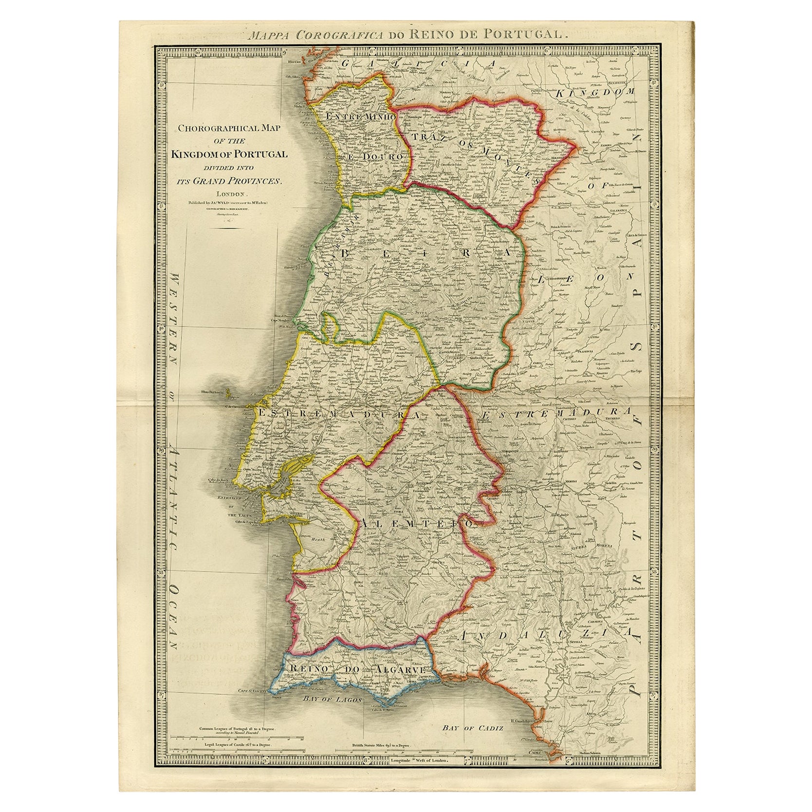
Engraved Large Map of The Kingdom of Portugal Original Handcolored, 1854
Located in Langweer, NL
Antique map titled 'Mappa Corografica do Reino de Portugal - Chorographical map of the Kingdom of Portugal divided into its Grand Provinces.'
Large map of...
Category
Antique 1850s Maps
Materials
Paper

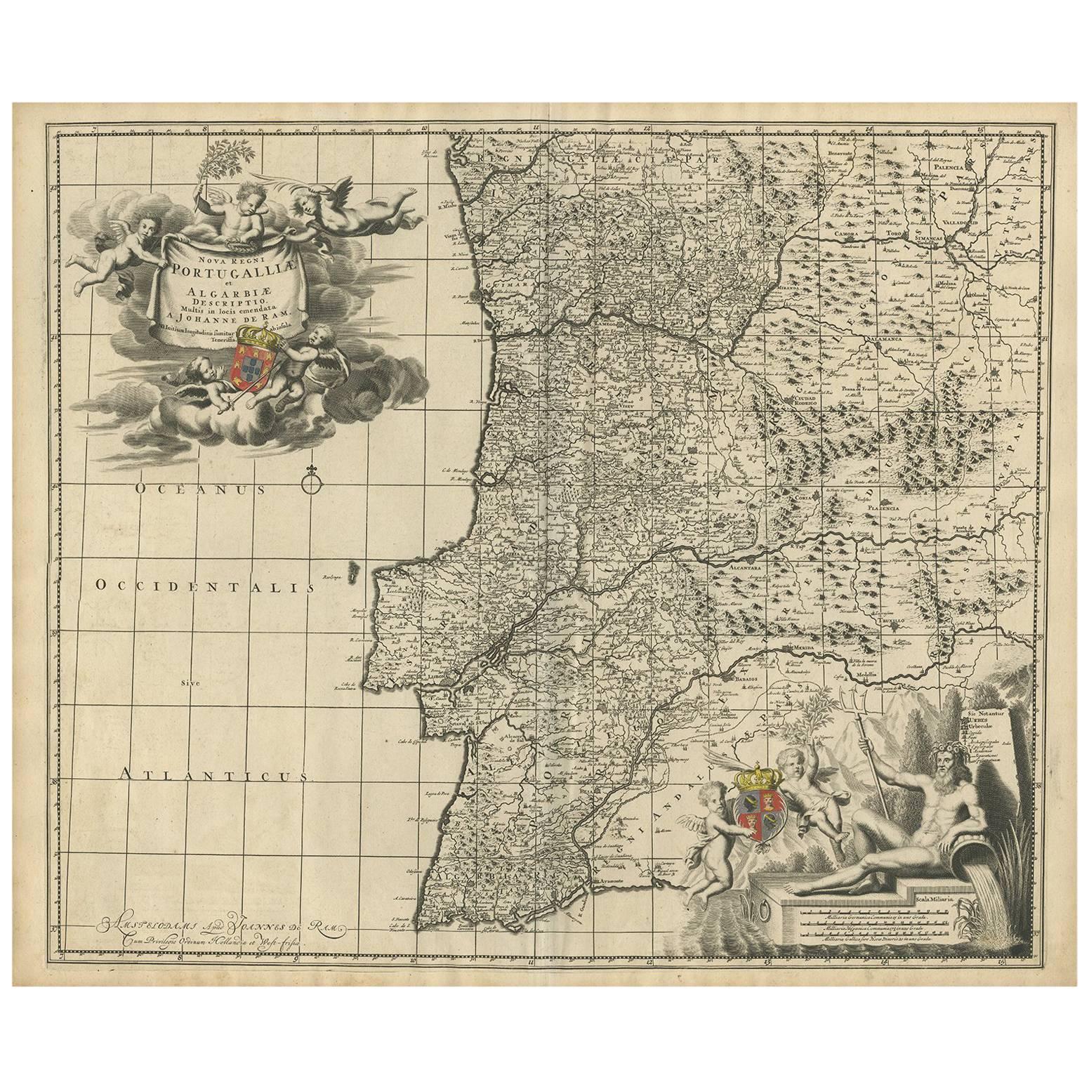
Antique Map of Portugal by J. De Ram, circa 1680
Located in Langweer, NL
A detailed map of Portugal. Embellished with beautiful cartouche, sailing vessels and many putti. Very rare edition by J. de Ram, circa 1680.
Category
Antique Late 17th Century Maps
Materials
Paper
$773 Sale Price
20% Off
You May Also Like
Portugal: A Large 17th Century Hand-colored Map by Sanson and Jaillot
By Nicholas Sanson d
Abbeville
Located in Alamo, CA
This large hand-colored map entitled "Le Royaume de Portugal et des Algarves Divisee en see Archeveches, Eveches et Territoires Par le Sr Sanson" was originally created by Nicholas S...
Category
1690s Landscape Prints
Materials
Engraving

Portugal: A Large 17th Century Hand-colored Map by Sanson and Jaillot
By Nicolas Sanson
Located in Alamo, CA
This large hand-colored map entitled "Le Royaume de Portugal et des Algarves Divisee en see Archeveches, Eveches et Territoires Par le Sr Sanson" was originally created by Nicholas S...
Category
Antique 1690s French Maps
Materials
Paper

18th Century Hand Colored Map of Spain and Portugal by Visscher
By Nicolaes Visscher II
Located in Alamo, CA
This is an early 18th century map of Spain and Portugal, with attractive original hand-coloring, entitled "Hispaniae et Portugalliae Regna per Nicolaum Visscher cum Privilegio Ordinu...
Category
Antique Early 18th Century Dutch Maps
Materials
Paper

Map of Spain and Portugal - Original Etching - Late 19th Century
Located in Roma, IT
This Map of Spain and Portugal is an etching realized by an anonymous artist.
The state of preservation of the artwork is good with some small diffused stains.
Sheet dimension: 28...
Category
Late 19th Century Modern Figurative Prints
Materials
Etching

1751 Map of Spain Castilla Robert De Vaugondy 1st Edition, Ric.a001
Located in Norton, MA
Large Spain Castilla Robert De Vaugondy
1751 1st Edition
-Colored- Ric.a001
Coming from a family of cartographers, a descendant of the famous Nicolas Sanson and ordinary geographer of the king, Gilles Robert de Vaugondy makes himself known by his maps of the French provinces.
He published an Essay on the History of Geography (1755) from which he excluded the physical geography "too systematic". After a Small Atlas (1748), he draws a universal Atlas (1758), a portable Atlas (1762).
His Atlas of the revolutions of the globe remains unpublished. His warnings and prefaces, his book reviews reveal a Cartesian mind and solid knowledge.
Very early, he associates with his works his son Didier who publishes, since 1742, the methodical tables of Nicolas Sanson, two Globes, one terrestrial, the other celestial (1752).
He is credited with a map of Poland...
Category
Antique 18th Century Unknown Maps
Materials
Paper

Map of Spain and Portugal - Etching by Pierre François Tardieu - 1837
Located in Roma, IT
Map of Spain and Portugal is an Etching realized by Pierre François Tardieu in 1837.
Good conditions.
The artwork is realized in a well-balanced composition. the artwork and belong...
Category
1830s Modern Figurative Prints
Materials
Lithograph

More Ways To Browse
Map Of Native American Tribes
Old Spice
Romania Map
Used Furniture Nova Scotia
18th Century Scottish Collectibles
Antique Furniture Northumberland
Antique Map Nova Scotia
Antique Map Palestine
California Island Map
Constantinople Map
Croatian Antiques
Jamaican Antique
Large Map Of Italy
Louisiana Antiques
Maps South East Asia
New Jersey Antique Furniture
Ptolemy Map
Antique Maps Massachusetts