Items Similar to 1901 Chart of Port Jefferson, New York


Want more images or videos?
Request additional images or videos from the seller
1 of 12
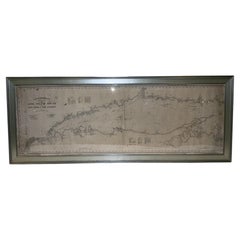
1901 Chart of Port Jefferson, New York
$299
£228.07
€260.27
CA$420.47
A$461.48
CHF 242.51
MX$5,491.50
NOK 3,100.05
SEK 2,832.83
DKK 1,944.47
About the Item
Original chart by George Eldridge of Port Jefferson on Long Island, New York. The identified waters include Setauket Harbor, Mount Misery Point, and Match Rock. Two channels are marked to cross from Port Jefferson, New York, to Bridgeport, Connecticut. Matted and framed.
Weight: 7 lbs.
Overall Dimensions: 20"H x 23"W
Made: America
Material: Paper
Date: 1901
- Dimensions:Height: 20 in (50.8 cm)Width: 23 in (58.42 cm)Depth: 1 in (2.54 cm)
- Materials and Techniques:
- Place of Origin:
- Period:1900-1909
- Date of Manufacture:1901
- Condition:
- Seller Location:Norwell, MA
- Reference Number:Seller: 11041stDibs: LU1741245291262
About the Seller
5.0
Gold Seller
Premium sellers maintaining a 4.3+ rating and 24-hour response times
Established in 1967
1stDibs seller since 2015
430 sales on 1stDibs
Typical response time: 5 hours
- ShippingRetrieving quote...Shipping from: Norwell, MA
- Return Policy
More From This Seller
View AllMariners charts of Massachusett Long Island by George Eldridge 1901
Located in Norwell, MA
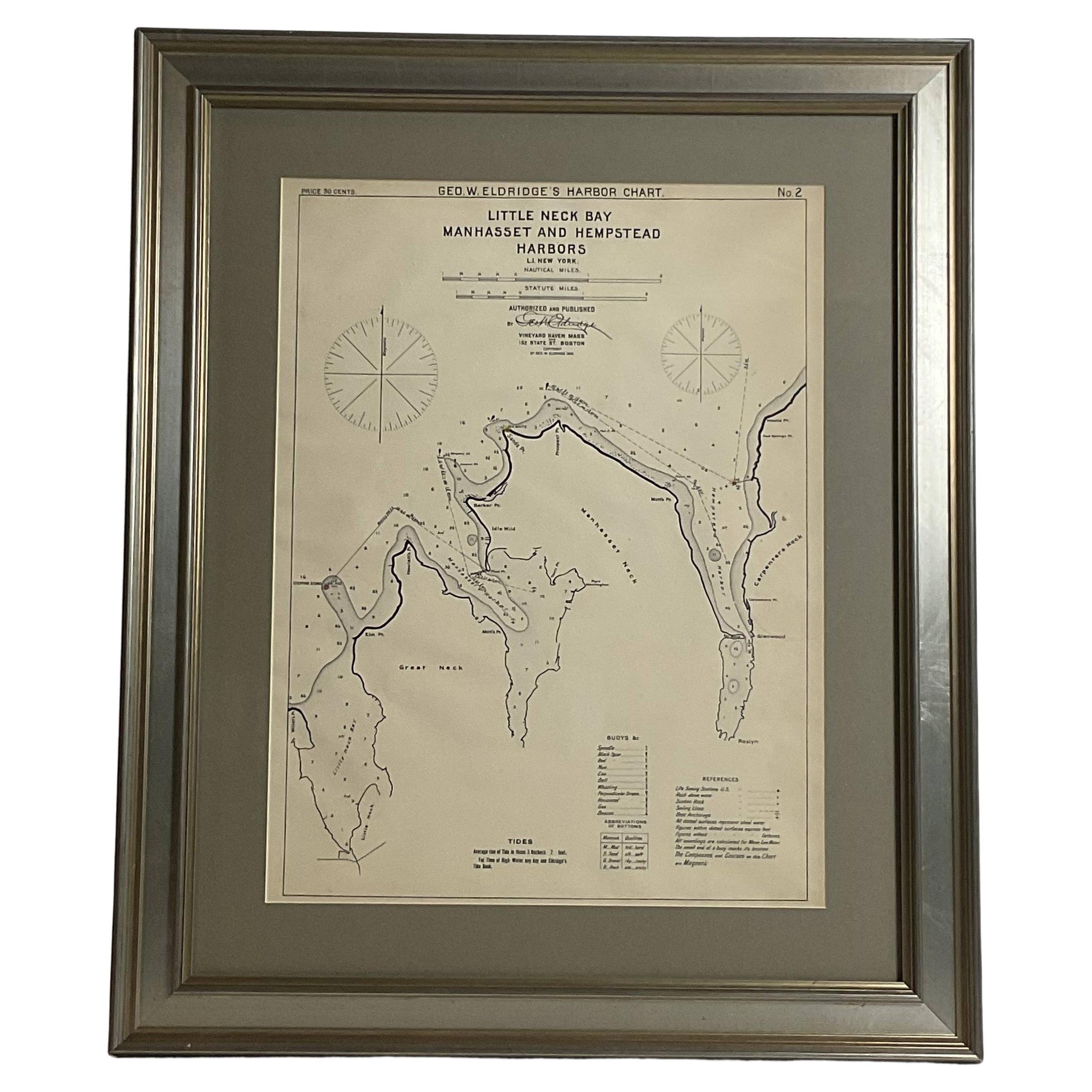
Nautical Chart showing the harbor and local waters of the Little Neck Bay, Manhasset and Hempstead Harbors. The chart displays depths, buoys, lighthouses, etc., Shown is Manhasset Ne...
Category
Antique Early 1900s North American Prints
Materials
Paper

Copy of 1901 Chart of Boston Harbor
Located in Norwell, MA
Later copy after an original Boston Harbor chart by George Eldridge of Vineyard Haven and Boston. Detailed chart of Boston Harbor from the Neponset River in Quincy south down to Kimb...
Category
Vintage 1910s North American Prints
Materials
Paper

1898 Chart of Boston Bay
Located in Norwell, MA
Original 1898 chart showing Massachusetts Bay with the coast from Cape Ann to Cape Cod. This is a U.S. Navy Geodetic survey chart. All towns are noted along the coast. Framed with gl...
Category
Antique 1890s Nautical Objects
Materials
Paper

$1,495
1896 Chart of the New Haven Harbor
Located in Norwell, MA
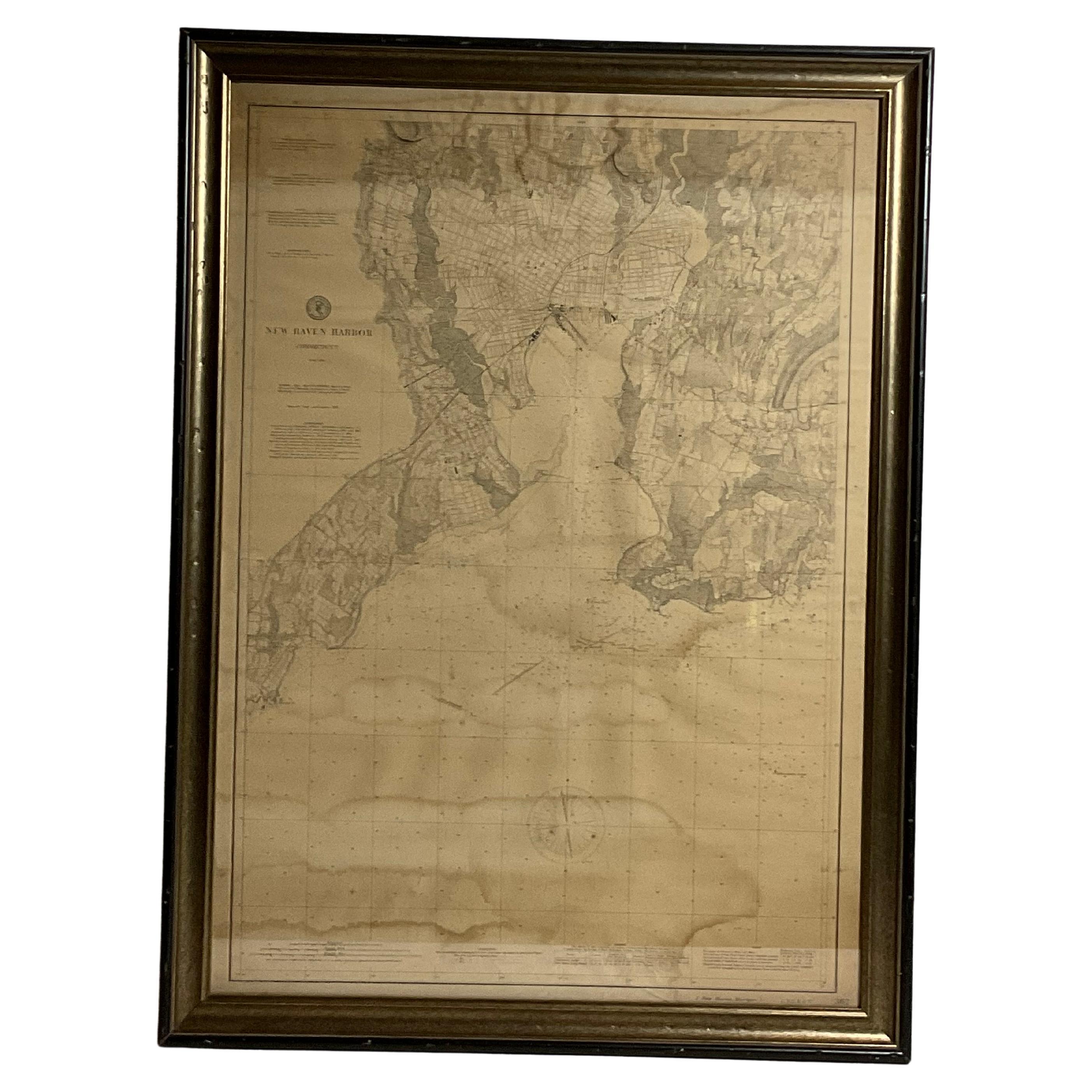
New Haven Harbor Chart published May 1896 by the United States Coast and geodetic survey. This chart is also a map of the land around the harbor and etc., loaded with detail. Nicely ...
Category
Antique 1890s North American Prints
Materials
Paper

Mariners Chart of Marion Massachussets by George Eldridge 1901
Located in Norwell, MA
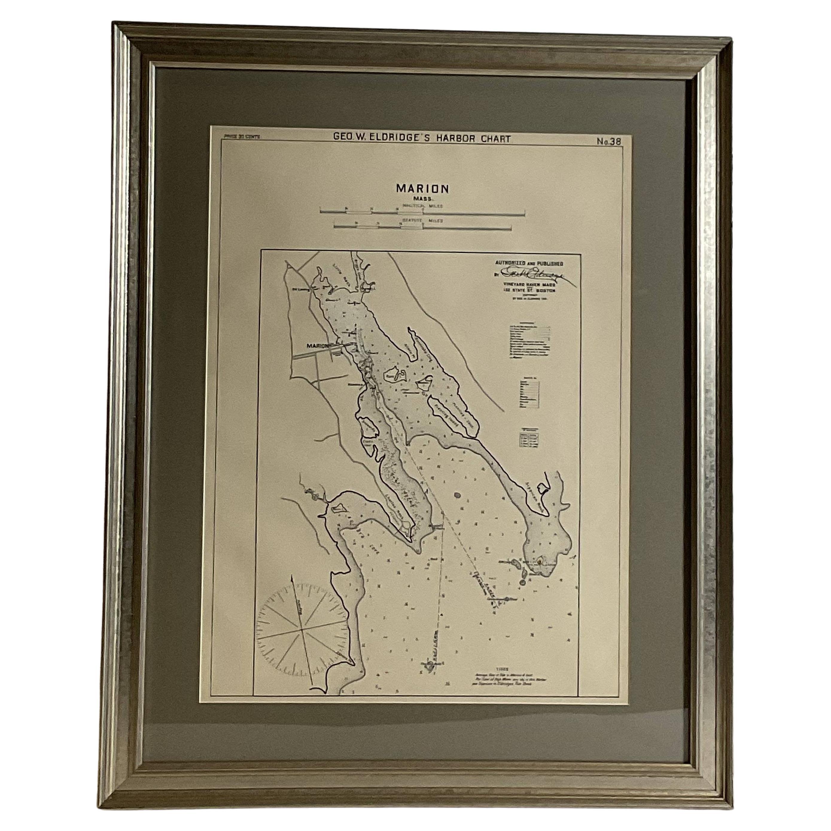
Nautical chart showing the harbor and local waters of Marion Harbor., The chart displays depth, buoys, lighthouses, etc., Shown are Planting Island, Ram Island, Sippican Neck, Little...
Category
Antique Early 1900s North American Prints
Materials
Paper

1905 Chart of Long Island Sound by Eldridge
Located in Norwell, MA
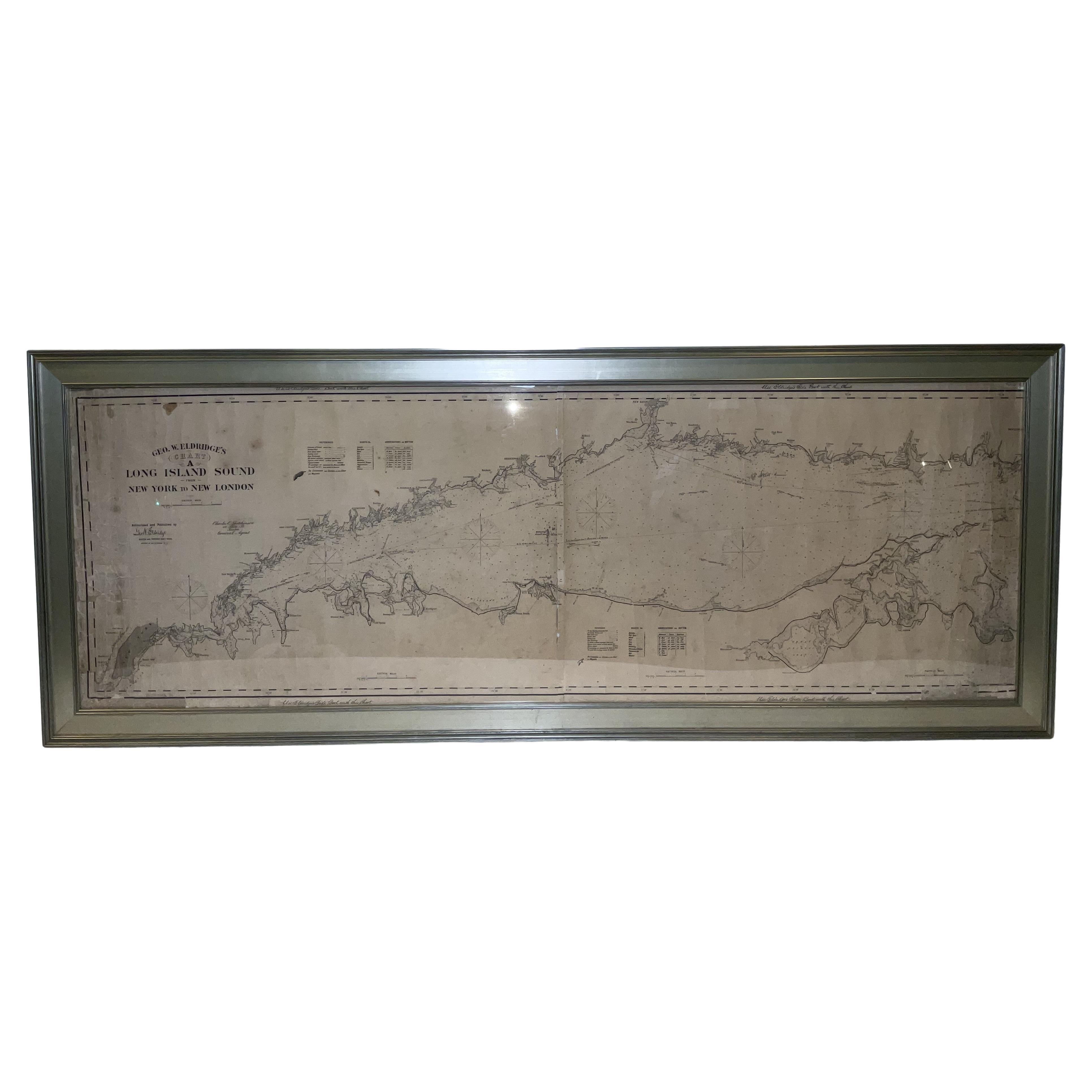
Original chart of Long Island Sound by George Eldridge, date-stamped 1905. Also includes the seller's name, Ships Chandler Charles C. Hutchinson, 152 State St., Boston, General Agent...
Category
Antique Early 1900s North American Prints
Materials
Paper
You May Also Like
Rare 18th C. Newport Map
Located in Sandwich, MA
Rare 18th C, Map titled "A plan of the town of Newport in the province of Rhode Island". Earliest printed plan of Newport, published for the use of the British just prior to their o...
Category
Antique 1770s American Maps
Materials
Paper

$19,500 / item
Original Antique Map of the American State of New York ( Southern Part ) 1903
Located in St Annes, Lancashire
Antique map of New York ( Southern Part )
Published By A & C Black. 1903
Original colour
Good condition
Unframed.
Free shipping
Category
Antique Early 1900s English Maps
Materials
Paper

Large Original Antique Map of New York State( Southern ), USA, C.1900
Located in St Annes, Lancashire
Fabulous map of Southern New York . With a vignette of Lower Manhattan
Original color.
Engraved and printed by the George F. Cram Company, Indianapolis.
Published, C.1900.
Unfram...
Category
Antique 1890s American Maps
Materials
Paper

Antique Lithography Map, Environs of Southampton, English, Framed, Victorian
Located in Hele, Devon, GB
This is an antique lithography map 'The Environs of Southampton'. An English, framed town engraving of cartographic interest by John James Dower, dating to the Victorian period and ...
Category
Antique Late 19th Century British Victorian Maps
Materials
Wood
1872 Map of Hudson, Union and Essex Counties, New Jersey
Located in Savannah, GA
A hand-colored topographical map of New Jersey’s Hudson, Union and Essex Counties from the Atlas of New Jersey by F.W. Beers, published in 1872.
sight 15 by 22½ inches
frame 20 by...
Category
Antique 1870s American Prints
Materials
Glass, Wood, Paper

Original Antique Map of the American State of New York ( Western Part ) 1903
Located in St Annes, Lancashire
Antique map of New York ( Western Part )
Published By A & C Black. 1903
Original colour
Good condition
Unframed.
Free shipping
Category
Antique Early 1900s English Maps
Materials
Paper

More Ways To Browse
Used Furniture North York
Cream Soup
Early English Silver
Paisley Rugs and Carpets
Black And Chrome Lounge Chair
Vintage 1930 Dining Room Set
Antique Brass And Copper
Antique Cow
Antique Harvest
Antique Victorian Dining Tables
Environment Furniture
Italian Plastic Chairs
Made In Belgium
Black Crystal Glasses
French Mid Century Modern Rug
China Silk Rug
Chrome Glass Coffee Tables
Antique Italian Chairs