Want more images or videos?
Request additional images or videos from the seller
1 of 5
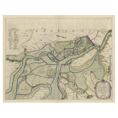
1902 "Topographical Map of the Original District of Columbia, After Arnold
$7,160List Price
About the Item
- Dimensions:Height: 29.75 in (75.57 cm)Width: 32.5 in (82.55 cm)Depth: 0.25 in (6.35 mm)
- Materials and Techniques:
- Period:1900-1909
- Date of Manufacture:1902
- Condition:Wear consistent with age and use. Map is trimmed to border; laid on period linen. Old folds are visible, and several small edge chips or repairs. Original hand coloring, still bright and attractive. Map is presented unframed.
- Seller Location:Colorado Springs, CO
- Reference Number:Seller: M3011stDibs: LU909724645272
About the Seller
4.9
Platinum Seller
Premium sellers with a 4.7+ rating and 24-hour response times
Established in 2010
1stDibs seller since 2011
474 sales on 1stDibs
Typical response time: 9 hours
Authenticity Guarantee
In the unlikely event there’s an issue with an item’s authenticity, contact us within 1 year for a full refund. DetailsMoney-Back Guarantee
If your item is not as described, is damaged in transit, or does not arrive, contact us within 7 days for a full refund. Details24-Hour Cancellation
You have a 24-hour grace period in which to reconsider your purchase, with no questions asked.Vetted Professional Sellers
Our world-class sellers must adhere to strict standards for service and quality, maintaining the integrity of our listings.Price-Match Guarantee
If you find that a seller listed the same item for a lower price elsewhere, we’ll match it.Trusted Global Delivery
Our best-in-class carrier network provides specialized shipping options worldwide, including custom delivery.You May Also Like
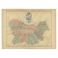
Orense in Depth: A 1902 Topographical Map of Galicia
s Mountainous Province
Located in Langweer, NL
The map is a detailed cartographic representation of the province of Orense (Ourense in Galician), located in the northwest of Spain, as it was in 1902. Here's a brief description an...
Category
Antique Early 1900s Maps
Materials
Paper
$295 Sale Price
20% Off
Free Shipping
H 14.77 in W 20.08 in D 0 in
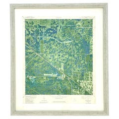
Vintage 50s Topographical Map of the Florida Keys
Located in West Palm Beach, FL
A fabulous vintage 50 original topographical map. A depiction of the Florida Keys and the surrounding waters. Part of a set of three maps. The other t...
Category
Mid-20th Century American Maps
Materials
Glass, Wood, Paper
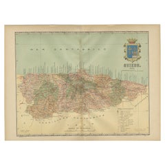
The Lay of the Land: A 1901 Topographic Map of Oviedo, Asturias
Located in Langweer, NL
The province depicted on the historical map on offer, Oviedo, corresponds to the modern-day autonomous community of Asturias in northwestern Spain. Here are some points about Asturia...
Category
Antique Early 1900s Maps
Materials
Paper
$371 Sale Price
20% Off
Free Shipping
H 14.77 in W 20.08 in D 0 in
Topographical and Infrastructure Map of the Province of Valencia, 1901
Located in Langweer, NL
A historical map of the province of Valencia, dated 1901. The map includes intricate details such as topographical features, with mountain ranges and river systems prominently marked...
Category
Antique Early 1900s Spanish Maps
Materials
Paper

$495 Sale Price
20% Off
Free Shipping
H 20.08 in W 14.77 in D 0.01 in
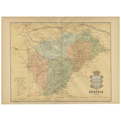
Topographical and Administrative Cartography of Segovia in Spain, 1902
Located in Langweer, NL
An original old map of the province of Segovia from the year 1902. Segovia is a historic area located in the central part of Spain, northwest of Madrid. Known for its rich history, a...
Category
Antique Early 1900s Maps
Materials
Paper
$276 Sale Price
20% Off
Free Shipping
H 14.77 in W 20.08 in D 0 in
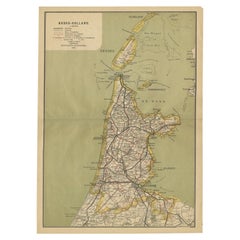
Antique Map of Noord-Holland, Province of The Netherlands, 1902
Located in Langweer, NL
Antique map titled 'Noord-Holland'. Lithographed map of the province of Noord-Holland, the Netherlands. This map originates from 'Atlas van Nederland'. Artists and Engravers: Publish...
Category
20th Century Maps
Materials
Paper
Large Topographical and Geological Map of the Teshio Oil Field,
1936
Located in Langweer, NL
Topographical and geological map of the Teshio oil field. Shows location of oil well, oil sand, natural gas, coal, Sulphur spring, anticlinal axis, prof...
Category
20th Century Maps
Materials
Linen, Paper
$1,143 Sale Price
20% Off
H 72.64 in W 38.39 in D 0.02 in
Antique Map of the District of Boemi Agoeng by Stemler, c.1875
Located in Langweer, NL
Antique map titled 'Kaart van de Afdeling Boemi Agoeng.' This map shows the Indonesian district of Boemi Agoeng (Lampong districts). Originates from 'Tijdschrift Aardrijkskundig Geno...
Category
Antique 19th Century Maps
Materials
Paper
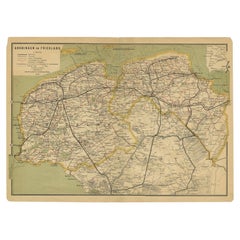
Antique Map of the Dutch Provinces Groningen and Friesland, 1902
Located in Langweer, NL
Antique map titled 'Groningen en Friesland'. Lithographed map of the provinces of Groningen and Friesland, the Netherlands. This map originates from 'Atlas van Nederland'. Artists an...
Category
20th Century Maps
Materials
Paper
Original Map of the Military Situation After the Dutch Blockade of Antwerp, 1648
Located in Langweer, NL
Antique map titled 'Tabula Castelli ad Sandflitam (..)'.
This map depicts the complex military situation that had developed after the Dutch blockade of Antwerp. All entrenchment'...
Category
Antique 1640s Maps
Materials
Paper
$638 Sale Price
20% Off
H 19.69 in W 22.05 in D 0 in
More From This Seller
View All1904 "Nell
s Topographical Map of the State of Colorado"
Located in Colorado Springs, CO
This highly detailed pocket map is a topographical map of the state of Colorado by Louis Nell from 1904. The map "has been compiled from all available...
Category
Antique Early 1900s American Maps
Materials
Leather, Paper

1868 "Lloyd
s Topographical Railway Map of North America..." Hanging Wall Map
Located in Colorado Springs, CO
Presented is “Lloyd's Topographical Railway Map of North-America, or the United States Continent in 1900.” This map was published by J. T. Lloyd, in New York, in 1868. A large, hangi...
Category
Antique 1860s American Late Victorian Maps
Materials
Linen, Paper

Vintage "Colorado, Crested Butte Sheet" USGS Topographical Map, 20th Century
By United States Geological Survey
Located in Colorado Springs, CO
Presented is a vintage "Colorado, Crested Butte Sheet" topographical map, first published by the United States Geological Survey. Highly detailed, the map captures the rugged topogra...
Category
20th Century American Maps
Materials
Paper
1845 "Ensign
s Travellers
Guide and Map of the United States" Hand-Colored Map
Located in Colorado Springs, CO
This is an exquisite and dramatic steel-engraved wall map of the United States, published by T.
E. H. Ensign in 1845. The map depicts the development and settlement of the Unit...
Category
Antique 1840s American Victorian Maps
Materials
Paper

1859 "Map of the United States of America..." by J. H. Colton
By J.H. Colton
Located in Colorado Springs, CO
Presented is an 1859 “Map of the United States of America, the British Provinces, Mexico, the West Indies and Central America with Part of...
Category
Antique 1850s American Maps
Materials
Paper

1840 Map of the City of Washington Published by William M. Morrison
Located in Colorado Springs, CO
This map, printed in 1840, is a detailed representation of Washington, D.C. in the mid-19th century. The map shows block numbers, wards, and government buildings as well as details o...
Category
Antique 1840s American Federal Maps
Materials
Paper
