Want more images or videos?
Request additional images or videos from the seller
1 of 13
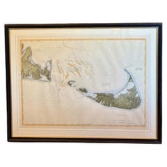
1907 Chart of Nantucket Harbor by George Eldridge
Price:$375
$495List Price
About the Item
- Dimensions:Height: 24 in (60.96 cm)Width: 30 in (76.2 cm)Depth: 1 in (2.54 cm)
- Materials and Techniques:
- Place of Origin:
- Period:1900-1909
- Date of Manufacture:1907
- Condition:
- Seller Location:Norwell, MA
- Reference Number:Seller: 11071stDibs: LU1741245291292
About the Seller
5.0
Vetted Professional Seller
Every seller passes strict standards for authenticity and reliability
Established in 1967
1stDibs seller since 2015
440 sales on 1stDibs
Typical response time: 1 hour
Authenticity Guarantee
In the unlikely event there’s an issue with an item’s authenticity, contact us within 1 year for a full refund. DetailsMoney-Back Guarantee
If your item is not as described, is damaged in transit, or does not arrive, contact us within 7 days for a full refund. Details24-Hour Cancellation
You have a 24-hour grace period in which to reconsider your purchase, with no questions asked.Vetted Professional Sellers
Our world-class sellers must adhere to strict standards for service and quality, maintaining the integrity of our listings.Price-Match Guarantee
If you find that a seller listed the same item for a lower price elsewhere, we’ll match it.Trusted Global Delivery
Our best-in-class carrier network provides specialized shipping options worldwide, including custom delivery.You May Also Like
DesBarres (1776) Chart of Nantucket Island, 1966 Restrike
Located in Nantucket, MA
DesBarres (1776) Chart of Nantucket Island and the Eastern Half of Martha's Vineyard Restrike, published by the Massachusetts Historical Society in association with Haley
Steel...
Category
Vintage 1960s American Other Maps
Materials
Paper
George Sylvester Viereck, The House of the Vampire, 1907, First Edition
Located in Hillsborough, NJ
Author: VIERECK, George Sylvester.
Title: The House of the Vampire.
Publisher: NY: Moffat, Yard & Company, 1907.
FIRST EDITION OF THE AUTHORS FIRST NOVEL. 1 vol., publishe...
Category
Antique Early 1900s American Books
Materials
Fabric
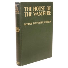
$1,100
H 7.5 in W 5.5 in D 1.25 in
1907 Rubaiyat of Omar Khayyam
By Edward Fitzgerald
Located in Bath, GB
A sumptuously bound copy of this noted work, presented here in a highly decorative Bumpus binding, with exquisite gilt detail and watered silk pastedowns.
The 1907 edition of the wo...
Category
Antique Early 1900s British Books
Materials
Paper

Antique Chart of the World by Johnston
1909
Located in Langweer, NL
Antique map titled 'Chart of the World on Mercator's Projection Showing the directions of the Oceans Currents with the Routes and Distances Between Principal Ports'. Detailed map of ...
Category
Early 20th Century Maps
Materials
Paper
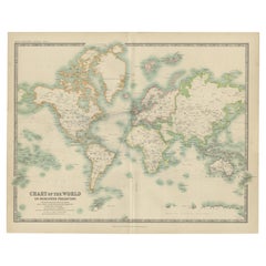
Chart of the Harbour of Liverpool
Located in Cheshire, GB
PL Burdett A Chart of the Harbour of Liverpool hand coloured. Encased in an ebonised frame.
Dimensions
Height 23.5 Inches
Width 28 Inches
Depth 1 Inches
Category
Early 20th Century British Maps
Materials
Paper

Large University Chart “Physical Map of Africa” by Bacon
Located in Godshill, Isle of Wight
Large university chart “Physical Map of Africa” by Bacon
W&A K Johnston’s Charts of Physical Maps By G W Bacon,
This is colorful Physical map of North America, it is large lithograph set...
Category
Early 20th Century Folk Art Posters
Materials
Linen

15 Volumes of
Flora van Deutschland
by J. Sturm, 1906-1907
Located in Langweer, NL
15 volumes of 'Flora von Deutschand' by J. Sturm. Published 1906-1907. 2nd rev. ed., 15 vols., 888 (chromo)lithogr. plates, num. ills., orig. unif. hcl.
Category
20th Century Books
Materials
Paper

$710 Sale Price / set
20% Off
H 5.91 in W 4.06 in D 0.79 in
Tony Sarg Map of Nantucket Town, 1937
By Tony Sarg
Located in Nantucket, MA
Tony Sarg Map of Residential Main Street, Nantucket, 1937, a black and white printed map of our historic downtown area, with images of each building, street names and whimsical figur...
Category
Vintage 1930s American Other Maps
Materials
Paper

Antique Genealogy Chart of the Leaders of Europe by Chatelain, 1732
Located in Langweer, NL
Antique print titled 'Carte Genealogique des Souverains de l'Europe (..)'. Chart of the royal line of the great Frankish major, Aega. As early as the 14th century the Hapsburgs attem...
Category
Antique 18th Century Prints
Materials
Paper
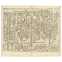
$265 Sale Price
20% Off
H 17.45 in W 20.48 in D 0 in
Antique Chart of the Voyage of Captain Cook by Benard, 1780
Located in Langweer, NL
Antique map titled 'Carte des Découvertes faites dans la Mer Pacifique sur la Vaisse au de Roi, La Resolution, Commandé par le Capitaine Cook en 1774'. Chart detailing the 1774 voyag...
Category
Antique 18th Century Maps
Materials
Paper
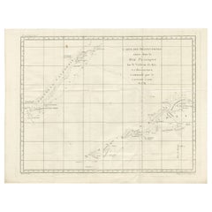
$265 Sale Price
20% Off
H 16.34 in W 21.26 in D 0 in
More From This Seller
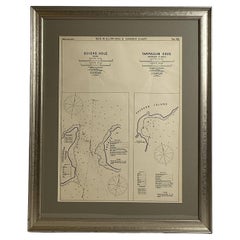
View AllMariners Chart of Quicks Hole and Tarpaulin Cove by George Eldridge 1901
Located in Norwell, MA
Nautical chart showing the harbor and local waters of Naushon Island Quick Holes. The chart display depths buoys, lightness, etc., The chart shows the cove in Naushon with ships stor...
Category
Antique Early 1900s North American Maps
Materials
Paper
Mariners Chart of Marion Massachussets by George Eldridge 1901
Located in Norwell, MA
Nautical chart showing the harbor and local waters of Marion Harbor., The chart displays depth, buoys, lighthouses, etc., Shown are Planting Island, Ram Island, Sippican Neck, Little...
Category
Antique Early 1900s North American Prints
Materials
Paper

1873 Martha
s Vineyard and Nantucket Chart
Located in Norwell, MA
Original chart of Nantucket and Martha's Vineyard by George Eldridge, Cartographer, 125 State Street, Boston. Dated 1873. Mounted to canvas. Also showing the coast of Cape Cod includ...
Category
Antique 1870s North American Maps
Materials
Paper

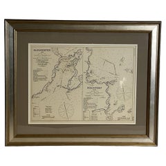
Mariners Chart of Gloucester and Rockport by George Eldridge 1910
Located in Norwell, MA
Nautical chart showing the harbor and local water. The chart display depths buoys, lighthouses, etc., This chart shows Eastern Point, Rocky Neck, Stage head, Thatcher Island, Sandy B...
Category
Vintage 1910s North American Prints
Materials
Paper
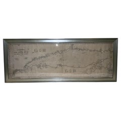
1905 Chart of Long Island Sound by Eldridge
Located in Norwell, MA
Original chart of Long Island Sound by George Eldridge, date-stamped 1905. Also includes the seller's name, Ships Chandler Charles C. Hutchinson, 152 State St., Boston, General Agent...
Category
Antique Early 1900s North American Prints
Materials
Paper
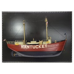
Half Model of the Lightship Nantucket
Located in Norwell, MA
Museum quality half model of the Lightship Nantucket. This fine model has a carved hull, countless milled brass fittings, built up cabins, etc. Details inc...
Category
2010s North American Models and Miniatures
Materials
Wood
Still Thinking About These?
All Recently ViewedMore Ways To Browse
Cream Soup
Early English Silver
Paisley Rugs and Carpets
Black And Chrome Lounge Chair
Vintage 1930 Dining Room Set
Antique Brass And Copper
Antique Cow
Antique Harvest
Antique Victorian Dining Tables
Environment Furniture
Italian Plastic Chairs
Made In Belgium
Black Crystal Glasses
French Mid Century Modern Rug
China Silk Rug
Chrome Glass Coffee Tables
Antique Italian Chairs
Antique Walnut Bar