Want more images or videos?
Request additional images or videos from the seller
1 of 9
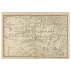
1912 "Texas" Map by Rand McNally
Co.
$850List Price
About the Item
- Creator:Rand McNally Co. (Maker)
- Dimensions:Height: 14.25 in (36.2 cm)Width: 17 in (43.18 cm)Depth: 0.75 in (1.91 cm)
- Materials and Techniques:
- Place of Origin:
- Period:1910-1919
- Date of Manufacture:1912
- Condition:Additions or alterations made to the original: Framed to archival and conservation standards by Artem Art Services in Colorado Springs, CO in March of 2025. Wear consistent with age and use. Minor fading.
- Seller Location:Colorado Springs, CO
- Reference Number:Seller: M3761stDibs: LU909746600962
About the Seller
4.9
Platinum Seller
Premium sellers with a 4.7+ rating and 24-hour response times
Established in 2010
1stDibs seller since 2011
474 sales on 1stDibs
Typical response time: 9 hours
Authenticity Guarantee
In the unlikely event there’s an issue with an item’s authenticity, contact us within 1 year for a full refund. DetailsMoney-Back Guarantee
If your item is not as described, is damaged in transit, or does not arrive, contact us within 7 days for a full refund. Details24-Hour Cancellation
You have a 24-hour grace period in which to reconsider your purchase, with no questions asked.Vetted Professional Sellers
Our world-class sellers must adhere to strict standards for service and quality, maintaining the integrity of our listings.Price-Match Guarantee
If you find that a seller listed the same item for a lower price elsewhere, we’ll match it.Trusted Global Delivery
Our best-in-class carrier network provides specialized shipping options worldwide, including custom delivery.You May Also Like
Large Original Antique Map of Arkansas by Rand McNally, circa 1900
By Rand McNally
Co.
Located in St Annes, Lancashire
Fabulous monochrome map with red outline color
Original color
By Rand, McNally & Co.
Published, circa 1900
Unframed
Minor edge tears.
Category
Antique Early 1900s American Edwardian Maps
Materials
Paper

$90
Free Shipping
H 20.5 in W 27.5 in D 0.07 in
Original Antique Map of South Dakota by Rand McNally, circa 1900
By Rand McNally
Co.
Located in St Annes, Lancashire
Fabulous monochrome map with red outline color
Original color
By Rand, McNally & Co.
Published, circa 1900
Unframed
Minor edge tears.
Category
Antique Early 1900s American Edwardian Maps
Materials
Paper

$90
Free Shipping
H 14 in W 20.5 in D 0.07 in
Antique Railroad Map of the United States by Rand, McNally
Co, 1900
Located in Langweer, NL
Antique map titled 'Rand, McNally & Co's New Official Railroad map of the United States with portions of The Dominion of Canada, The Republic of Mexico and the West Indies'. Large railroad map of the United States, sectionalised and laid on linen. Map shows state boundaries for the United States, Mexico, the West Indies, and lower portion of Canada; major cities and towns, military posts, Native American reservations, and railroads; Oklahoma and "Indian Territory." Inset: "Map of Alaska...
Category
20th Century Maps
Materials
Linen, Paper

$2,228 Sale Price
25% Off
Free Shipping
H 30.91 in W 43.9 in D 0.02 in
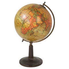
Diminutive 19th C Globe on Stand by Rand McNally
By Rand McNally
Co.
Located in New York, NY
Exceptional antique globe on stand, by Rand McNally.
The 6” diameter globe is supported by the half circle brass meridian, which is mounted t...
Category
Antique 19th Century American Campaign Models and Miniatures
Materials
Iron
Kansas Railroad Map 1888 – Rand McNally Antique Lithograph
Located in Langweer, NL
Kansas Railroad Map 1888 – Rand McNally Antique Lithograph
This antique 1888 map of Kansas by Rand, McNally & Co. offers a detailed view of the state during a period of rapid expans...
Category
Antique Late 19th Century American Maps
Materials
Paper
Nebraska Railroad Map 1888 – Rand McNally Antique Lithograph
Located in Langweer, NL
Nebraska Railroad Map 1888 – Rand McNally Antique Lithograph
This finely detailed map of Nebraska, published by Rand, McNally & Co. in 1888, provides an excellent overview of the st...
Category
Antique Late 19th Century American Maps
Materials
Paper
World Antique Map c.1888 – Rand McNally, Continents
Territories
Located in Langweer, NL
Antique Map of Mexico – Rand McNally, circa 1888
This antique map titled “Rand, McNally & Co.’s Mexico” was published around 1888 and depicts Mexico in the late 19th century, a peri...
Category
Antique Late 19th Century American Maps
Materials
Paper
Indian Territory Map 1888 – Rand McNally Antique Lithograph
Located in Langweer, NL
Indian Territory Map 1888 – Rand McNally Antique Lithograph
This antique 1888 map of Indian Territory, published by Rand, McNally & Co., is a remarkable record of the region that wo...
Category
Antique Late 19th Century American Maps
Materials
Paper
Dakota Territory Railroad Map 1888 – Rand McNally Antique Lithograph
Located in Langweer, NL
Antique Map of Dakota Territory – Rand McNally Railroad Map, 1888
This detailed 1888 map of Dakota by Rand, McNally & Co. captures the region in the final year before its division i...
Category
Antique Late 19th Century American Maps
Materials
Paper
$546
H 20.67 in W 14.18 in D 0.01 in
Antique Map of Southeastern New York by Rand McNally, Lithograph, 1888
Located in Langweer, NL
Antique Map of Southeastern New York – Rand McNally, circa 1888
This antique map of southeastern New York was published by Rand, McNally
Co. around 1888. It offers a detailed ...
Category
Antique Late 19th Century American Maps
Materials
Paper
$546
H 20.67 in W 14.18 in D 0.01 in
More From This Seller
View All1847 Antique Map of Mexico, Texas and California by Samuel Augustus Mitchell
By Samuel Augustus Mitchell 1
Located in Colorado Springs, CO
Presented is the second edition of Samuel Augustus Mitchell's Map of Mexico, Including Yucatan & Upper California, an important map showing the progress of the Mexican-American War. ...
Category
Antique 1840s American Maps
Materials
Paper

The Fountainhead by Ayn Rand, First Edition, 1943
By Ayn Rand
Located in Colorado Springs, CO
Rand, Ayn. The Fountainhead. New York: The Bobbs-Merrill Company, 1943. First edition printing. Octavo. Rebound in modern half red Moroccan leather and marbled boards, with gilt tooling and titles to the spine, and the original dust jacket bound-in.
Presented is a first edition printing of The Fountainhead by Ayn Rand...
Category
Vintage 1940s American Mid-Century Modern Books
Materials
Leather, Paper

1917 "New Hudson River Map" by Wallace Bruce, Later Edition, Folding Map
Located in Colorado Springs, CO
Presented is a 1917 printing of “New Hudson Map” by Wallace Bruce. The map was published by Bryant Union Publishing Co., in New York City. The map is a later edition, issued in a distinct strip-chart format that is over 100 inches long. The map includes amazing detail, compiled mostly from U.S. Coast Survey data. It is drawn on a scale of 1.5 miles per inch, allowing ample space for it to show historical landmarks, landings, islands, list prominent residents, and more. The verso is filled with related text and illustrations about the Hudson River valley. The map folds into cream paper wrappers, titled "Hudson River Map...
Category
Vintage 1910s American Beaux Arts Maps
Materials
Paper
1864 Map of North America, Antique Hand-Colored Map, by Adolphe Hippolyte Dufour
Located in Colorado Springs, CO
Offered is a map of North America entitled Amerique du Nord from 1864. This rare, separately published wall map was produced by Adolphe Hippolyte Dufour. This map includes vibrant an...
Category
Antique 1860s French Maps
Materials
Paper

1812 United States Map, by Pierre Tardieu, Antique French Map Depicting the U.S.
By Pierre François Tardieu
Located in Colorado Springs, CO
1812 "United States of Nth America -- Carte des Etats-Unis De L'Amerique Septentrionale" Two-Sheet Map by Tardieu
This attractive map, published in Paris in 1812, is one of the most rare large format maps from the period. It features a view of the East Coast of the U.S. from Maryland to just below South Carolina. Additionally, Ellicott’s plan for the City of Washington D.C. is included at the top right and an illustration of Niagara Falls is shown at the bottom right with a description in both French and English. This extremely detailed map not only depicts the mountainous regions of the southeastern U.S., but also includes names of regions, rivers, and towns.
Based on the first state of Arrowsmith’s 4-sheet map of the United States, this map is completely engraved by Tardieu in Paris and showcases high quality engravings. This detailed map of the recently independent United States includes one of the largest and earliest examples of the Ellicott plan of Washington DC.
The artist, Pierre François Tardieu (PF Tardieu) was a very well-known map engraver, geographer, and illustrator. Awarded a bronze medal by King Louis-Phillipe for the accuracy and beauty of his map-making, Tardieu produced many fine works including maps of Louisiana...
Category
Antique 1810s French Maps
Materials
Paper

1870 "Johnson
s Europe" Map Published by A. J. Johnson
Located in Colorado Springs, CO
Presented is an original 1870 "Johnson’s Europe" map. First published in 1864, this map was issued as pages 87 and 88 in the 1870 edition of “Johnson's New Illustrated (Steel Plate) ...
Category
Antique 1870s American Victorian Maps
Materials
Paper
