1 of 11
1950s School Chart, At the Railway Station, Rossignol, Henri Mercier
$232.87List Price
About the Item
- Dimensions:Height: 22.05 in (56 cm)Width: 29.93 in (76 cm)Depth: 0.04 in (1 mm)
- Style:Mid-Century Modern (Of the Period)
- Materials and Techniques:
- Place of Origin:
- Period:
- Date of Manufacture:1950-1960
- Condition:Wear consistent with age and use.
- Seller Location:Retie, BE
- Reference Number:1stDibs: LU1474214791061
Authenticity Guarantee
In the unlikely event there’s an issue with an item’s authenticity, contact us within 1 year for a full refund. DetailsMoney-Back Guarantee
If your item is not as described, is damaged in transit, or does not arrive, contact us within 7 days for a full refund. Details24-Hour Cancellation
You have a 24-hour grace period in which to reconsider your purchase, with no questions asked.Vetted Professional Sellers
Our world-class sellers must adhere to strict standards for service and quality, maintaining the integrity of our listings.Price-Match Guarantee
If you find that a seller listed the same item for a lower price elsewhere, we’ll match it.Trusted Global Delivery
Our best-in-class carrier network provides specialized shipping options worldwide, including custom delivery.You May Also Like
Double-Sided Cottagecore Wall Chart Fishing Harbour Goods Railway Station
Located in Berghuelen, DE
A classical pull-down double-sided wall chart illustrating on one side a traditional fishing harbour with lighthouse and on the other side a vintage look goods station. Used as teach...
Category
Vintage 1970s German Country Prints
Materials
Canvas, Wood, Paper
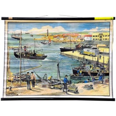
$380
H 25.2 in W 35.44 in D 0.79 in
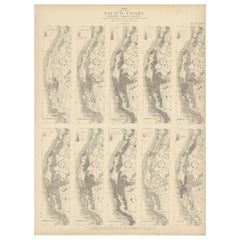
Antique Chart of the Pacific Coast
1874
Located in Langweer, NL
Antique chart titled 'Maps of the Pacific Coast exhibiting various subjects. Compiled from the statistics of the eight and ninth census of the United Sta...
Category
Antique Late 19th Century Maps
Materials
Paper
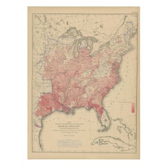
Antique Chart of the US Consumption Deaths,
1874
Located in Langweer, NL
Antique chart titled 'Map showing the proportion of deaths from consumption to deaths from all causes. Compiled from the returns of mortality at the nint...
Category
Antique Late 19th Century American Maps
Materials
Paper
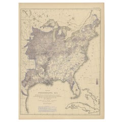
Antique Chart of the US Malarial Deaths,
1874
Located in Langweer, NL
Antique chart titled 'Map showing the proportion of deaths from malarial diseases to deaths from all causes. Compiled from the returns of mortality at th...
Category
Antique Late 19th Century Maps
Materials
Paper
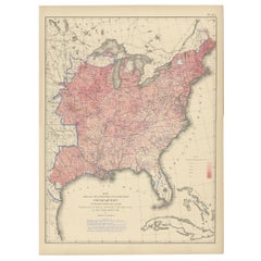
Antique Chart of the US Predominating Sex, 1874
Located in Langweer, NL
Antique chart titled 'Map of predominating sex showing the local excess of males or of females in the distribution of population over the territory of th...
Category
Antique Late 19th Century Maps
Materials
Paper
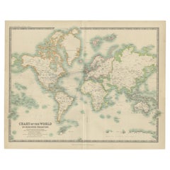
Antique Chart of the World by Johnston
1909
Located in Langweer, NL
Antique map titled 'Chart of the World on Mercator's Projection Showing the directions of the Oceans Currents with the Routes and Distances Between Principal Ports'. Detailed map of ...
Category
Early 20th Century Maps
Materials
Paper
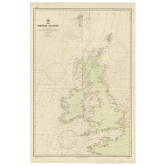
Large Sea Chart of the British Islands, 1918
Located in Langweer, NL
Antique map titled 'The British Islands'.
Large sea chart of the British Islands. It shows Ireland, Scotland, England, the Shetland Islands and part of Fra...
Category
Vintage 1910s Maps
Materials
Paper
Antique Anatomical Wall Chart Depicting the Human Skeleton
Located in Berghuelen, DE
Antique Anatomical Wall Chart Depicting the Human Skeleton
A rare 19th century anatomical wall chart depicting the human skeleton. On the sides On the...
Category
Early 20th Century German Victorian Prints
Materials
Paper

Antique Chart of the Storm Centres of the United States, 1874
Located in Langweer, NL
Antique chart titled 'U.S. Signal Service chart showing the frequency of storm centres. Number of storm centres passing over each point deduced from the average of the two years Marc...
Category
Antique Late 19th Century American Maps
Materials
Paper

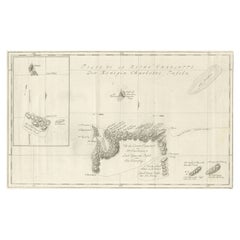
Original Antique Chart of the Santa Cruz Islands, 1774
Located in Langweer, NL
Antique print titled 'Isles de la Reine Charlotte (..)'.
A detailed chart of the Santa Cruz islands, to the north of the New Hebrides, with Carte...
Category
Antique 1770s Maps
Materials
Paper