Want more images or videos?
Request additional images or videos from the seller
1 of 9
1972 Framed San Antonio, Texas Map
$595List Price
About the Item
- Dimensions:Height: 46 in (116.84 cm)Width: 36 in (91.44 cm)Depth: 1.25 in (3.18 cm)
- Materials and Techniques:
- Place of Origin:Canada
- Period:
- Date of Manufacture:1972
- Condition:Wear consistent with age and use.
- Seller Location:New York, NY
- Reference Number:Seller: N2312751stDibs: LU973612894172
About the Seller
5.0
Vetted Professional Seller
Every seller passes strict standards for authenticity and reliability
Established in 2002
1stDibs seller since 2013
1,363 sales on 1stDibs
Authenticity Guarantee
In the unlikely event there’s an issue with an item’s authenticity, contact us within 1 year for a full refund. DetailsMoney-Back Guarantee
If your item is not as described, is damaged in transit, or does not arrive, contact us within 7 days for a full refund. Details24-Hour Cancellation
You have a 24-hour grace period in which to reconsider your purchase, with no questions asked.Vetted Professional Sellers
Our world-class sellers must adhere to strict standards for service and quality, maintaining the integrity of our listings.Price-Match Guarantee
If you find that a seller listed the same item for a lower price elsewhere, we’ll match it.Trusted Global Delivery
Our best-in-class carrier network provides specialized shipping options worldwide, including custom delivery.You May Also Like
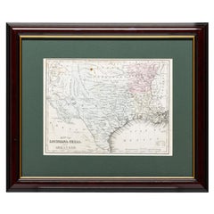
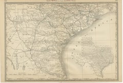
Framed Map of Texas Circa 1880
Located in Coeur d
Alene, ID
Framed circa 1880 map of Texas with Louisiana and Arkansas. Well detailed. Great for display in any home. Encased in cherry and gold frame with dark green mating. Size: 11" x 9", fra...
Category
Antique Late 19th Century American Maps
Materials
Paper
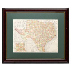
Framed Map of Texas Circa 1908
Located in Coeur d
Alene, ID
Framed circa 1908 map of Texas. Each county separated and colored with panhandle of Texas on same scale in left corner. Well detailed. Would display nicely in any home. Encased in ch...
Category
Early 20th Century American Maps
Materials
Paper
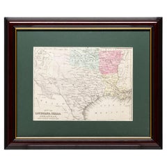
Framed Map of Texas Circa 1886
Located in Coeur d
Alene, ID
Framed circa 1886 map of Texas including Louisiana, Texas and Arkansas, with Indian territory. Well detailed. Great for display in any home. Encased in cherry and gold frame with dar...
Category
Antique Late 19th Century American Maps
Materials
Paper
Antique Map of the Eastern United States with Inset Map of Texas
Located in Langweer, NL
Antique map titled 'Verein-Staaten von Nord-America mit Ausnahme Florida's und der Westlichen Territorien'. This map extends as far west as Louisiana and only includes the northern p...
Category
Antique Mid-19th Century Maps
Materials
Paper

$515 Sale Price
20% Off
H 14.65 in W 17.84 in D 0.02 in
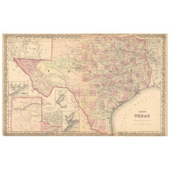
Large Antique Map of Texas with Panhandle
Bay Inset Maps, Colton, 1873
Located in Langweer, NL
Large Antique Map of Texas with Panhandle & Bay Inset Maps, Colton, 1873
This richly detailed and visually striking antique map of Texas was pub...
Category
Antique 1870s Maps
Materials
Paper
$871
H 17.52 in W 27.6 in D 0.01 in
Texas Antique Map 1888 – Railroads, Counties
Frontier Settlements
Located in Langweer, NL
Texas Railroad Map 1888 – Rand McNally Antique Lithograph
This antique 1888 map of Texas, published by Rand, McNally & Co., provides a detailed overview of the state during a critic...
Category
Antique Late 19th Century American Maps
Materials
Paper

$644
H 14.18 in W 20.67 in D 0.01 in
Antique Map 1888 – Southern Texas Railroads, Counties
Settlements
Located in Langweer, NL
Southern Texas Map 1888 – Rand McNally Antique Lithograph
This antique 1888 map of Southern Texas, published by Rand, McNally & Co., depicts the Gulf Coast and borderlands with Mexi...
Category
Antique Late 19th Century American Maps
Materials
Paper
$644
H 14.18 in W 20.67 in D 0.01 in
Framed Map of China
Located in Greenwich, CT
Map of China, 19th century. European print map of China
Conservation frame with walnut frame
Overall dimension : 28 1/2" wide 31" high 2" depth with fra...
Category
Antique 19th Century European Qing Prints
Materials
Paper

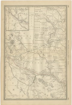
Western Texas Antique Map 1888 – Railroads, Counties
Frontier Towns
Located in Langweer, NL
Western Texas Map 1888 – Rand McNally Antique Lithograph
This antique 1888 map of Western Texas, published by Rand, McNally & Co., depicts the vast frontier counties of the region a...
Category
Antique Late 19th Century American Maps
Materials
Paper
$644
H 20.67 in W 14.18 in D 0.01 in
Map Bedfordshire General Framed
Located in BUNGAY, SUFFOLK
A general map of Bedfordshire with its hundreds
A scale of 5 miles
in the original green mount and traditional black and gold frame. Measures: 36cm 14" high.
Category
Antique 18th Century English Georgian Maps
Materials
Paper

More From This Seller
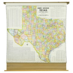
View All1850-1960 Cram
s Superior Latest Federal Census Texas Map
By G. F. Cram Company
Located in New York, NY
The 1850-1960 Cram's Superior Latest Federal Census Texas Map, crafted from pine wood, steel, and canvas, is a valuable historical cartographic piece. Publi...
Category
Vintage 1910s American Maps
Materials
Canvas
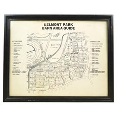
Framed Belmont Park Racetrack Barn Area Guide Map
Located in New York, NY
This piece was acquired from the Belmont Park racetrack in Elmont, New York. It displays an itemized map of the barn area at Belmont Park. It is made of acrylic with a black wood fra...
Category
20th Century American Maps
Materials
Acrylic, Wood
1990 Triple Perspective Planet Earth Map Framed Poster
Located in New York, NY
This decorative poster features a map of the Earth with a unique triple perspective view. It is enclosed in a black plastic frame, and the glass covering the poster is still intact. ...
Category
1990s American Posters
Materials
Glass, Plastic, Paper

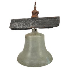
Antique Bronze Ship Bell w Clapper + Charred Wood Yoke
Located in New York, NY
Antique ship bell made of bronze, including its original charred wood yoke, steel and iron fittings. With clapper. A ship bell is used for the indication of time as well as other tra...
Category
Antique 19th Century American Religious Items
Materials
Bronze, Steel, Iron
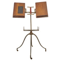
Antique Victorian Cast Iron
Oak Dictionary Stand
Located in New York, NY
Antique 1890s dictionary stand with a cast iron base featuring four curved legs ending in small casters. The top features two adjustable oak book rests, designed to hold large books ...
Category
Antique Late 19th Century American Victorian Musical Instruments
Materials
Iron
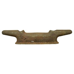
1940s 42.25 in. Cast Iron Deck Cleat
Located in New York, NY
Incorporate a touch of maritime history into your space with this early 1940s deck cleat. While it bears signs of weathering, including rust and some damage around the bolt holes, th...
Category
Vintage 1940s American Industrial Nautical Objects
Materials
Iron
Still Thinking About These?
All Recently ViewedMore Ways To Browse
Antique Furniture Plans
Antique Maps Of Africa
Antique Map India
Antique Map Of The South Of France
Antique English Maps
Indonesia Map
Ancient Maps
Antique Mining
Antique Atlas Furniture
Antique Maps Indonesia
Map Of India
China Map
Victorian Furniture 1920
Antique Maps Amsterdam
Antique Maps Of Russia
19th Century Map Of Africa
Map Of Britain
Antique Oregon