Want more images or videos?
Request additional images or videos from the seller
1 of 6
1987 "the Ian Fleming Thriller Map" by Aaron Silverman and Molly Maguire
$2,250List Priceper set
About the Item
- Dimensions:Height: 22.5 in (57.15 cm)Width: 29 in (73.66 cm)Depth: 0.75 in (1.91 cm)
- Sold As:Set of 2
- Materials and Techniques:
- Place of Origin:
- Period:1980-1989
- Date of Manufacture:1987
- Condition:Additions or alterations made to the original: Framed by Rio Grande Framing, in Colorado Springs, Colorado in June of 2022. Wear consistent with age and use.
- Seller Location:Colorado Springs, CO
- Reference Number:Seller: M3161stDibs: LU909731391532
About the Seller
4.9
Gold Seller
Premium sellers maintaining a 4.3+ rating and 24-hour response times
Established in 2010
1stDibs seller since 2011
473 sales on 1stDibs
Typical response time: 4 hours
Authenticity Guarantee
In the unlikely event there’s an issue with an item’s authenticity, contact us within 1 year for a full refund. DetailsMoney-Back Guarantee
If your item is not as described, is damaged in transit, or does not arrive, contact us within 7 days for a full refund. Details24-Hour Cancellation
You have a 24-hour grace period in which to reconsider your purchase, with no questions asked.Vetted Professional Sellers
Our world-class sellers must adhere to strict standards for service and quality, maintaining the integrity of our listings.Price-Match Guarantee
If you find that a seller listed the same item for a lower price elsewhere, we’ll match it.Trusted Global Delivery
Our best-in-class carrier network provides specialized shipping options worldwide, including custom delivery.You May Also Like
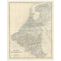
Antique Map of The Netherlands and Belgium by A
C, Black, 1870
Located in Langweer, NL
Antique map titled 'Holland & Belgium'. Original antique map of Map of The Netherlands and Belgium. This map originates from ‘Black's General Atlas of The World’. Published by A & C....
Category
Antique Late 19th Century Maps
Materials
Paper
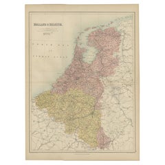
$240 Sale Price
20% Off
H 23.63 in W 17.52 in D 0.02 in
Antique Map of Belgium and the Netherlands by Johnston
1909
Located in Langweer, NL
Antique map titled 'Belgium and The Netherlands'. Original antique map of Belgium and the Netherlands. With inset maps of Amsterdam and Brussels. This m...
Category
Early 20th Century Maps
Materials
Paper
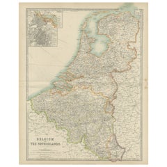
$240 Sale Price
20% Off
H 24.41 in W 19.49 in D 0.02 in
Antique Map of Belgium and the Netherlands by Johnston
c.1920
Located in Langweer, NL
Antique map titled 'Belgium and the Netherlands'. Original antique map of Belgium and the Netherlands. Published by W. & A.K. Johnston, circa 1920.
Category
20th Century Maps
Materials
Paper
Antique Map of the Netherlands and Belgium by Hérisson, 1829
Located in Langweer, NL
Title: 'Carte Routière du Royaume des Pays-Bas comprenant la Hollande et la Belgique'
**Publisher**: Eustache Hérisson
**Publication Year**: 1829
This original antique map is a detailed depiction of the Netherlands and Belgium, dating back to 1829. As a 'Carte Routière', it focuses on the road networks of the region, providing valuable historical insights into the transportation and geographical understanding of the early 19th century. The map's delineation of the Kingdom of the Netherlands, including both Holland and Belgium, is particularly noteworthy as it represents the political geography of the period shortly before Belgium's independence in 1830.
The map is sectionalised and laid on linen, a common practice in the 19th century for preserving and reinforcing maps, making them more durable and portable. This method of mounting also suggests that the map was intended for practical use, possibly by travelers or for educational purposes.
**Artist and Publisher**: Eustache Hérisson, the publisher of this map, was a known figure in the cartographic and publishing world of the early 19th century. His work is characterized by attention to detail and accuracy, making this map not only a beautiful piece of art but also a reliable historical document.
This map is a valuable historical artifact, offering insights into the geographical and political landscape of the Netherlands...
Category
Antique Mid-19th Century Maps
Materials
Paper
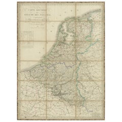
$720 Sale Price
20% Off
H 40.36 in W 30.32 in D 0.02 in
Antique Map of the Country Inhabited by the Samoyedic and Khanty People
1768
Located in Langweer, NL
Antique map titled 'Carte des Païs Habités par les Samojedes et Ostiacs'. Original antique map of the country inhabited by the Samoyedic and Khanty (Ostyak) peoples. Engraved by J.N....
Category
Antique Mid-18th Century Maps
Materials
Paper
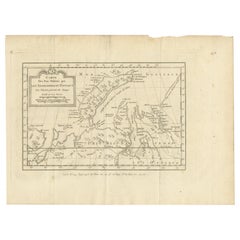
$192 Sale Price
20% Off
H 9.85 in W 13.19 in D 0.02 in
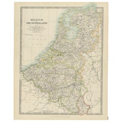
Antique Map of Belgium and The Netherlands by A.K. Johnston, 1865
Located in Langweer, NL
Antique map titled 'Belgium and The Netherlands'. This map originates from the ‘Royal Atlas of Modern Geography’ by Alexander Keith Johnston. Published by William Blackwood and Sons,...
Category
Antique Mid-19th Century Maps
Materials
Paper
Antique Map of the Philippines, Taiwan and Surroundings by Bonne
1780
Located in Langweer, NL
Antique map titled 'Les Isles Philippines, celle de Formose, le Sud de la Chine, les Royaumes de Tunkin, de Cochinchine, de Cambode, de Siam des Laos, avec partie de Pegu et D'Ava'. ...
Category
Antique Late 18th Century French Maps
Materials
Paper
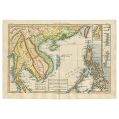
$432 Sale Price
20% Off
H 9.65 in W 13.78 in D 0.02 in
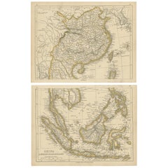
Antique Map of China and the East Indies by Lowry, 1852
Located in Langweer, NL
Antique map titled 'China & Indian Archipelago'. Two individual sheets of China and the East Indies. This map originates from 'Lowry's table Atlas constructed and engraved from the m...
Category
Antique Mid-19th Century British Maps
Materials
Paper
Antique Map of The United States and Canada by A
C. Black, 1870
Located in Langweer, NL
Antique map titled 'United States North Eastern Section and Canada'. Original antique map of Map of The United States North Eastern Section and Canada. This map originates from ‘Blac...
Category
Antique Late 19th Century Maps
Materials
Paper
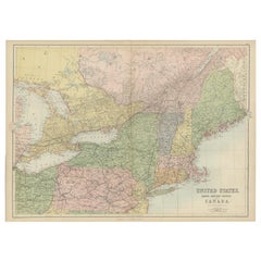
$240 Sale Price
20% Off
H 17.52 in W 23.63 in D 0.02 in
Antique Map of the Crimean Peninsula and Sevastopol by W. G. Blackie, 1859
Located in Langweer, NL
Antique map titled 'The Crimea'. Original antique map of the Crimean Peninsula, Black Sea and Sevastopol. This map originates from ‘The Imperial Atlas of Modern Geography’. Published...
Category
Antique Mid-19th Century Maps
Materials
Paper
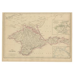
$168 Sale Price
20% Off
H 10.63 in W 14.57 in D 0.02 in
More From This Seller
View AllOctopussy and the Living Daylights by Ian Fleming, First Edition, 1966
By Ian Fleming
Located in Colorado Springs, CO
Fleming, Ian. Octopussy and The Living Daylights. London: Jonathan Cape, 1966. First edition, first impression. Octavo. Presented in the publisher's original unclipped dust jacket an...
Category
Vintage 1960s English Mid-Century Modern Books
Materials
Paper

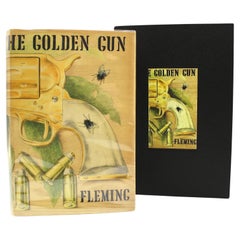
The Man With the Golden Gun by Ian Fleming, First Edition, in Original DJ, 1965
By Ian Fleming
Located in Colorado Springs, CO
Fleming, Ian. The Man with the Golden Gun. London: Jonathan Cape, 1965. First edition, second state printing. Octavo printing. In the original publisher’s black cloth boards with gil...
Category
Vintage 1960s English Mid-Century Modern Books
Materials
Paper
From Russia, With Love by Ian Fleming, First Edition, First Printing, Later DJ
By Ian Fleming
Located in Colorado Springs, CO
Fleming, Ian. From Russia, With Love. London: Jonathan Cape, (1957). First edition, first printing. Octavo, in original publisher's black boards, with silver and red embossed motif t...
Category
Vintage 1950s English Mid-Century Modern Books
Materials
Paper

“The Restaurant of the House of Representatives” Engraving by Harper
s Weekly
Located in Colorado Springs, CO
This original wood engraving is titled “The Restaurant of the House of Representatives, Washington, DC.” It was published as a double-page image, in the August 12, 1893 issue of the famous 19th century newspaper Harper’s Weekly. The print was illustrated by Charles Stanley Reinhardt.
The House Restaurant, a unique part of life in the Capitol, has been in the same location since the 1857 Capitol Expansion. Congressional members’ busy work schedule made the availability of food on site a necessity. But the restaurant also served as an informal meeting spot for members to continue conversations and deal making.
This 1893 print illustrates the convivial atmosphere. Details including elegantly dressed tables...
Category
Antique 1890s American Prints
Materials
Paper

Antique Map of Paris, "Carte Routiere des Environs de Paris" 1841
Located in Colorado Springs, CO
This beautiful hand-colored road map of Paris was published in 1841. The map shows Paris and the surrounding area in a folding pocket map. Organized and detailed for travelers, this ...
Category
Antique 1840s French Maps
Materials
Paper

The Sleeping Beauty, by C. S. Evans, Signed by Arthur Rackham, Limited Edition
Located in Colorado Springs, CO
Evans, C.S. (editor). Rackham, Arthur (illustrator). The Sleeping Beauty. London and Philadelphia: William Heinemann & J.B. Lippincott Co., 1920. F...
Category
Vintage 1920s English Art Deco Books
Materials
Paper
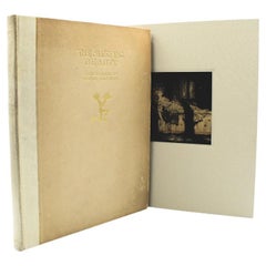
$3,800 Sale Price
20% Off
Still Thinking About These?
All Recently ViewedMore Ways To Browse
Pictorial Map
Vintage Bottle Of Champagne
Vintage Pictorial Maps
Maguire Furniture
Map Of Barbados
Nova Hollandia
Used Furniture Cleveland Ohio
Vintage Bartholomew Maps
1820 World Map
Aden Yemen
Antique Map New Orleans
Dakota Johnson
French School Map
L Tardieu
Laos Antique Map
Map New Holland
Mauritius Antique Map
Nantucket Poster