Items Similar to 19th Century Chart of New England Coast, 1847


Want more images or videos?
Request additional images or videos from the seller
1 of 8
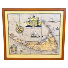
19th Century Chart of New England Coast, 1847
$1,400
£1,057.37
€1,221.43
CA$1,972.40
A$2,112.44
CHF 1,135.63
MX$25,656.84
NOK 14,349.29
SEK 13,137.84
DKK 9,126.32
About the Item
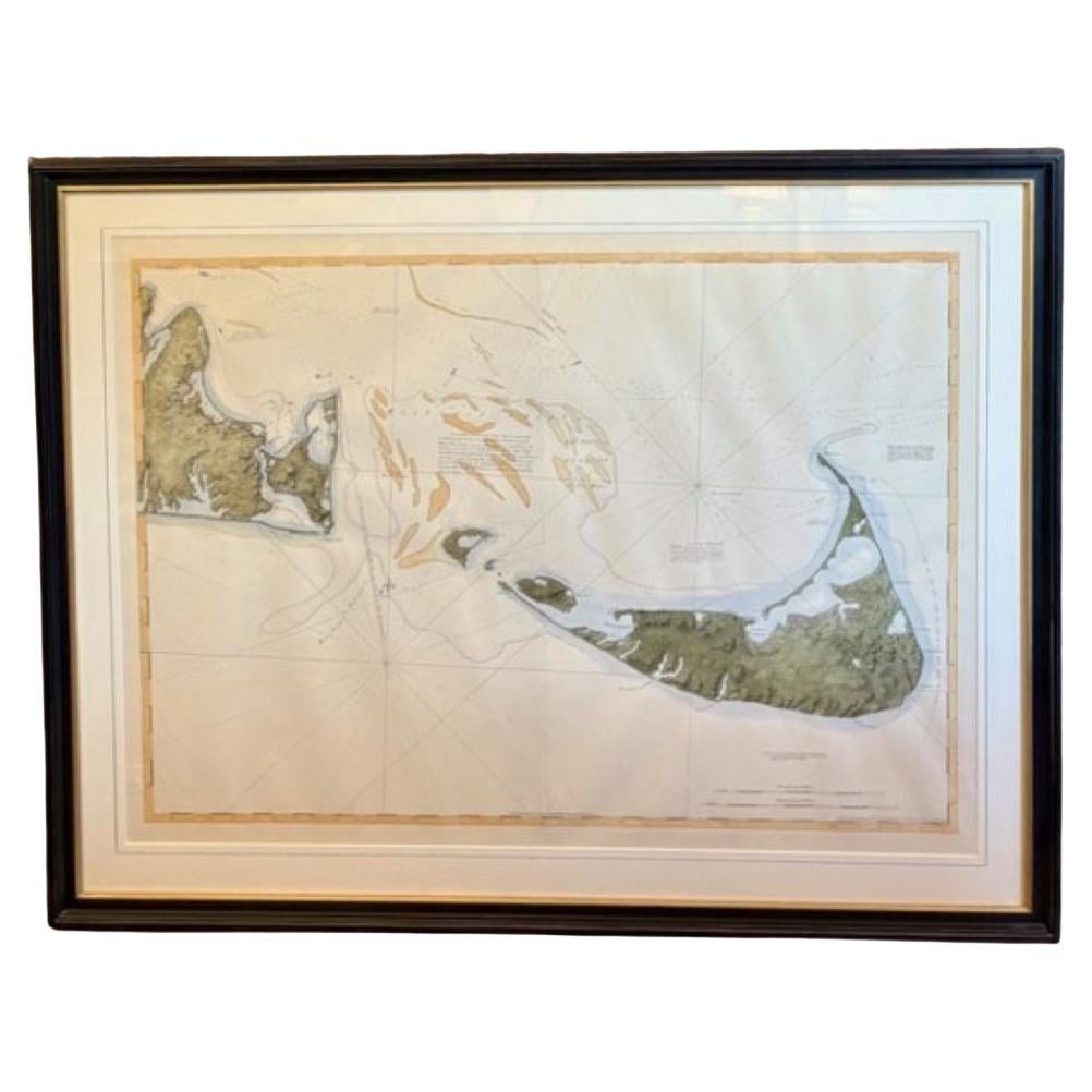
19th Century Chart of New England Coast: the U.S. Coast Survey Sketch A - Section 1, a triangulation chart showing the progress of the survey and details along the New England coastline from Nantucket to Passamaquoddy Bay, published in 1847. This is a scarce transitional chart updated and republished over a short number of years prior to the final completed coast survey. Hand-colored at a later date and recently mounted in bird's eye maple frame.
Excellent condition.
Measures: 36 in H x 31-1/4 in W
- Creator:U.S. Government (Maker)
- Dimensions:Height: 36 in (91.44 cm)Width: 31.25 in (79.38 cm)Depth: 0.5 in (1.27 cm)
- Style:Other (Of the Period)
- Materials and Techniques:Paper,Other
- Place of Origin:
- Period:
- Date of Manufacture:1847
- Condition:Additions or alterations made to the original: The chart was hand-colored after publication, as was popular over the years. Wear consistent with age and use.
- Seller Location:Nantucket, MA
- Reference Number:Seller: AD - 285-10 WYE1stDibs: LU903940243932
About the Seller
5.0
Gold Seller
Premium sellers maintaining a 4.3+ rating and 24-hour response times
1stDibs seller since 2010
281 sales on 1stDibs
Typical response time: <1 hour
- ShippingRetrieving quote...Shipping from: Nantucket, MA
- Return Policy
More From This Seller
View AllDesBarres (1776) Chart of Nantucket Island, 1966 Restrike
Located in Nantucket, MA
DesBarres (1776) Chart of Nantucket Island and the Eastern Half of Martha's Vineyard Restrike, published by the Massachusetts Historical Society in association with Haley
Steel...
Category
Vintage 1960s American Other Maps
Materials
Paper
Large U.S. Coast and Geodetic Survey Chart A of the Atlantic Coast, 1877
Located in Nantucket, MA
Large U.S. Coast and Geodetic Survey Chart A of the Atlantic Coast, 1877, re-issued in February 1881, a printed paper laid down on linen navigational chart of the U.S. Atlantic coast...
Category
Antique 1880s American Other Maps
Materials
Linen

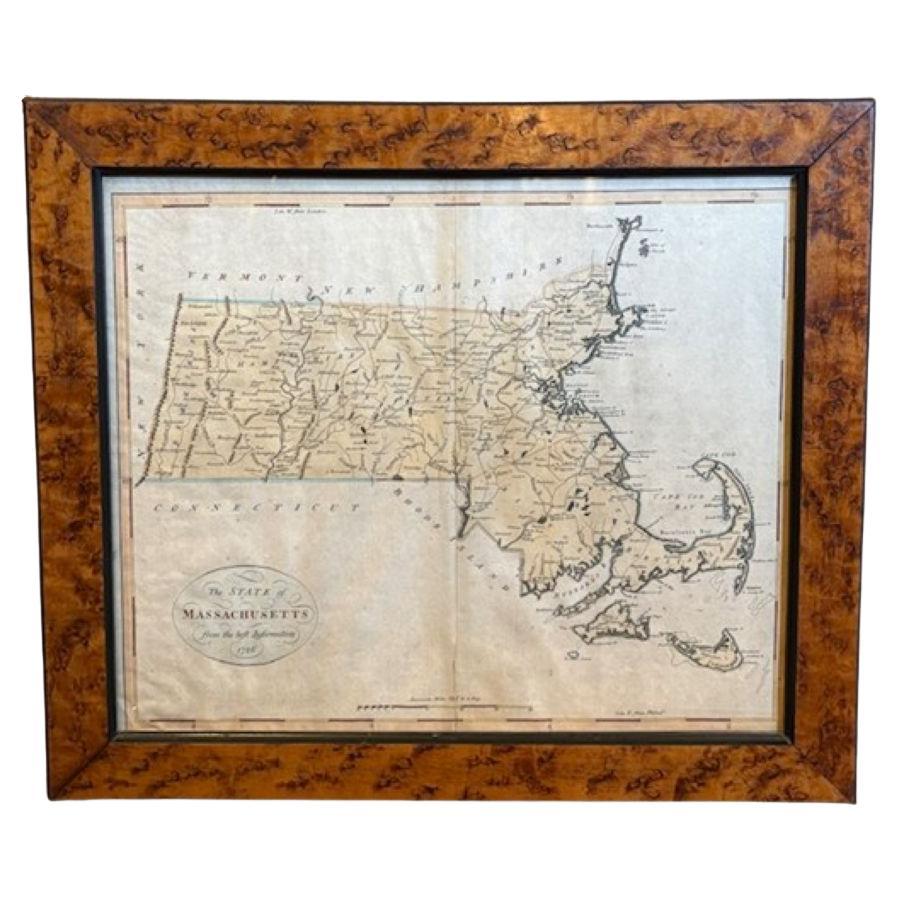
18th Century Hand Colored Map of The State of Massachusetts, 1796
Located in Nantucket, MA
18th Century Hand Colored Map of "The State of Massachusetts from the best information," 1796, by cartographer and illustrator John Reid published in his "American Atlas," a period e...
Category
Antique 1790s American American Colonial Maps
Materials
Paper

Nantucket High-Ways, By-Ways and Not-Ways Decorative Map by Tony Sarg, ca 1930
By Tony Sarg
Located in Nantucket, MA
Vintage Nantucket High-Ways, By-Ways and Not-Ways Decorative Map by Tony Sarg, (Nantucket: 1880 - 1942) circa 1930, a decorative tourist map of Nantucket Island with details of roadw...
Category
Vintage 1930s American Other Maps
Materials
Paper

Hand Colored Map of Nantucket by Austin Strong (1881 - 1952), circa 1921
Located in Nantucket, MA
Map of Nantucket by Austin Strong (1881 - 1952), circa 1921, an original print on paper whimsical map of Nantucket Island by Robert Louis Stevenson's step- grandson, noted stage set ...
Category
Vintage 1920s American Folk Art Maps
Materials
Paper
Tony Sarg Map of Nantucket Town, 1937
By Tony Sarg
Located in Nantucket, MA
Tony Sarg Map of Residential Main Street, Nantucket, 1937, a black and white printed map of our historic downtown area, with images of each building, street names and whimsical figur...
Category
Vintage 1930s American Other Maps
Materials
Paper

You May Also Like
Antique Maritime Chart of East Coast Virginia to Nova Scotia
Located in Norwell, MA
1920 nautical chart of the East Coast of the United States from Virginia to Maine, New Brunswick, and Nova Scotia. The chart shows Cape Cod, Long Island, the Connecticut coast, Jersey Shore, Maine, New Hampshire, etc. Very detailed, showing ports, lighthouses, shoals, depths, etc. The chart is by famous cartographer George W. Eldridge, compiled from surveys of the United States government, British Admiralty, George Eldridge, and others. First authorized by George Eldridge, published in 1916 by Wilfred O. White with a merchant's stamp of Charles Hutchinson...
Category
Vintage 1920s North American Maps
Materials
Paper

Chart of Boston
s North Shore
Located in Norwell, MA
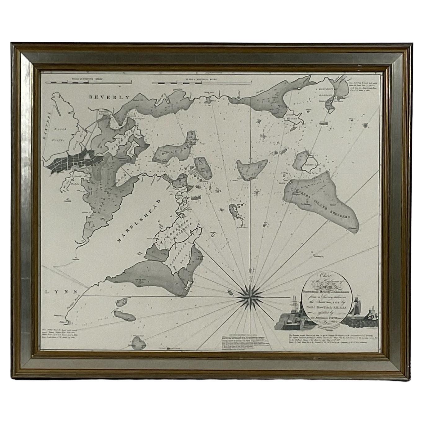
Rarely found restrike of an 1804 chart by Nathanael Bowditch of the Harbors of Salem, Marblehead, Beverly, and Manchester.
Showing the Islands of Great Misery, Satan, Cuney, Winter,...
Category
Vintage 1980s North American Maps
Materials
Paper

1898 Chart of Boston Bay
Located in Norwell, MA
Original 1898 chart showing Massachusetts Bay with the coast from Cape Ann to Cape Cod. This is a U.S. Navy Geodetic survey chart. All towns are noted along the coast. Framed with gl...
Category
Antique 1890s Nautical Objects
Materials
Paper

$1,495
Original Antique Map of the American State of Massachusetts, 1903
Located in St Annes, Lancashire
Antique map of Vermont and New Hampshire
Published By A & C Black. 1903
Original colour
Good condition
Unframed.
Free shipping
Category
Antique Early 1900s English Maps
Materials
Paper

1873 Martha
s Vineyard and Nantucket Chart
Located in Norwell, MA
Original chart of Nantucket and Martha's Vineyard by George Eldridge, Cartographer, 125 State Street, Boston. Dated 1873. Mounted to canvas. Also showing the coast of Cape Cod includ...
Category
Antique 1870s North American Maps
Materials
Paper

Original Antique Map of the American State of Maine, 1903
Located in St Annes, Lancashire
Antique map of Maine
Published By A & C Black. 1903
Original colour
Good condition
Unframed.
Free shipping
Category
Antique Early 1900s English Maps
Materials
Paper

More Ways To Browse
Antique Maple Frames
Antique New England Furniture
Birds Eye Maple Frame
Used Government Furniture
New England Antiques
Pair Arm Chairs
Sterling Silver Dinner Sets
United Chair Company
Italian Beech Chairs
Shirvan Rugs
Vintage Danish Tables And Chairs
1960s Glass Top Coffee Table
Black Glass Coffee Tables
Burnt Wood
Mid Century Wrought Iron Chairs
Earth Toned Rug
Black Marble Table Vintage
Goblets