Items Similar to 19th Century Map of Loir-et-Cher, France – Blois, Vendôme, Loire Valley Castles


Want more images or videos?
Request additional images or videos from the seller
1 of 9
19th Century Map of Loir-et-Cher, France – Blois, Vendôme, Loire Valley Castles
$166.82
£124.26
€140
CA$229.73
A$250.05
CHF 132.49
MX$3,007.28
NOK 1,684.64
SEK 1,543.78
DKK 1,066.71
About the Item
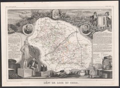
Antique Map of Loir-et-Cher, France by Vuillemin, 19th Century
A beautifully engraved 19th-century map of the département of Loir-et-Cher, drawn and engraved by Alexandre Vuillemin. The map shows towns, rivers, roads, and departmental boundaries highlighted with original hand-color.
The decorative embellishments are especially notable: on the left, portraits of King Louis XII of France and the poet Pierre Ronsard, both natives of the region. The coat of arms of Loir-et-Cher is depicted in the upper corner, while a finely detailed vignette shows the banks of the Loire River with its picturesque châteaux and river life.
Loir-et-Cher, part of the Centre-Val de Loire region, is historically renowned for its grand Renaissance castles such as Chambord, Cheverny, and Blois, all along the Loire Valley, which has been recognized as a UNESCO World Heritage site. This map not only illustrates the geography of the département but also pays tribute to its cultural and historical legacy.
Alexandre Vuillemin (1812–1880), a French cartographer, produced these département maps with a characteristic blend of precision and decorative flourish, making them highly sought after by collectors today.
Condition report: Very good condition. Strong impression with vivid original hand coloring. Minor toning and faint foxing around the sheet edges, not intruding into the printed area.
Framing tips: A dark wood or black frame with ivory matting would present this map elegantly, allowing the blue hand coloring and engraved portraits to stand out. Adding a gilt fillet would further highlight the decorative elements.
Technique: Engraving with original hand color
Maker: Alexandre Vuillemin, France, mid-19th century
- Dimensions:Height: 10.28 in (26.1 cm)Width: 12.8 in (32.5 cm)Depth: 0.01 in (0.2 mm)
- Materials and Techniques:Paper,Engraved
- Place of Origin:
- Period:
- Date of Manufacture:circa 1850
- Condition:Condition report: Very good condition. Strong impression with vivid original hand coloring. Minor toning and faint foxing around the sheet edges, not intruding into the printed area.
- Seller Location:Langweer, NL
- Reference Number:Seller: BG-13331-401stDibs: LU3054346798492
About the Seller
5.0
Recognized Seller
These prestigious sellers are industry leaders and represent the highest echelon for item quality and design.
Platinum Seller
Premium sellers with a 4.7+ rating and 24-hour response times
Established in 2009
1stDibs seller since 2017
2,824 sales on 1stDibs
Typical response time: 1 hour
- ShippingRetrieving quote...Shipping from: Langweer, Netherlands
- Return Policy
More From This Seller
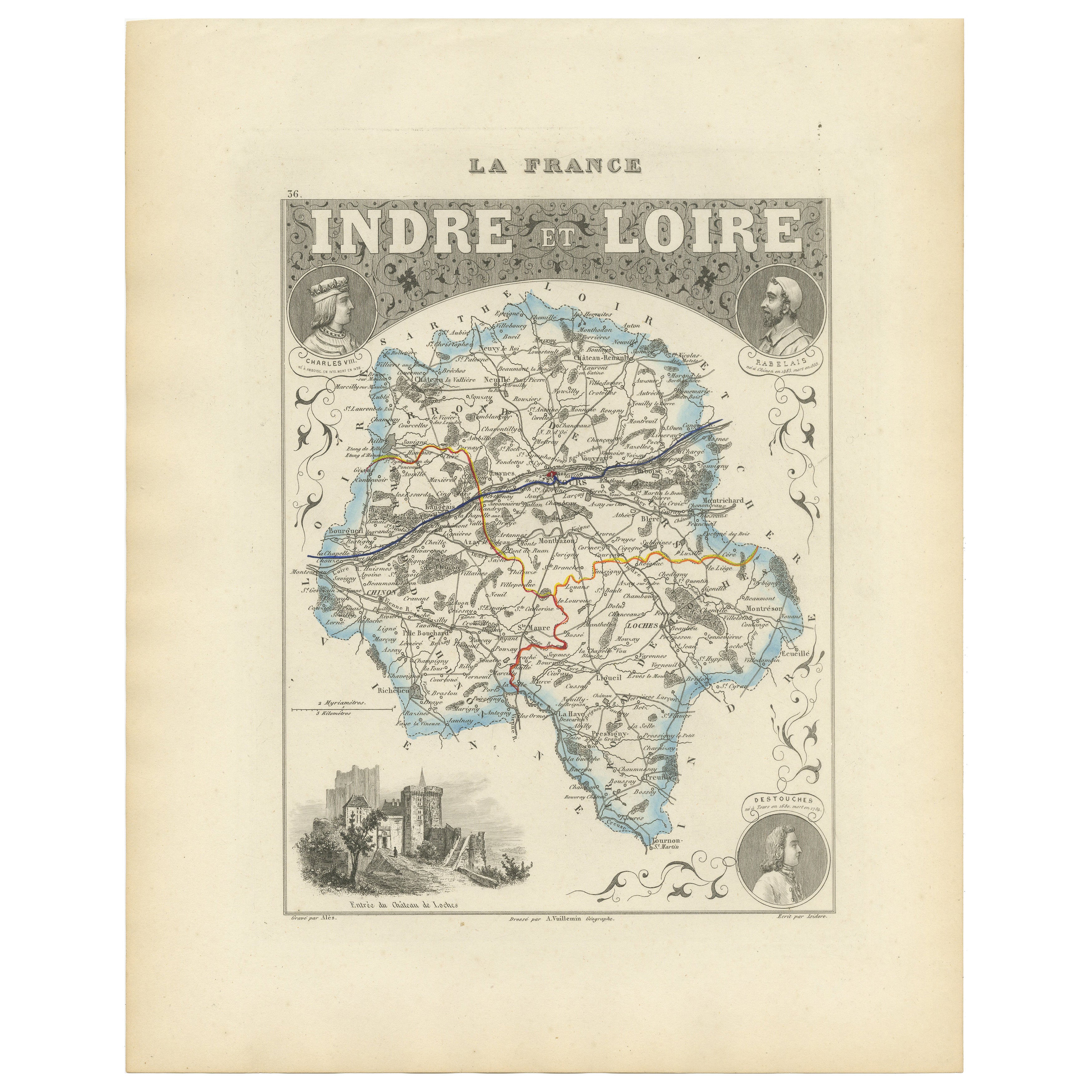
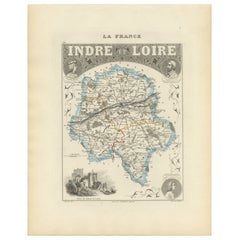
View AllAntique French Map of Indre-et-Loire with Tours, Amboise, Chinon, 1800s
Located in Langweer, NL
Antique Map of Indre-et-Loire, France by Vuillemin, 19th Century
This beautifully engraved map illustrates the département of Indre-et-Loire, located in the Centre-Val de Loire regi...
Category
Antique Mid-19th Century French Maps
Materials
Paper
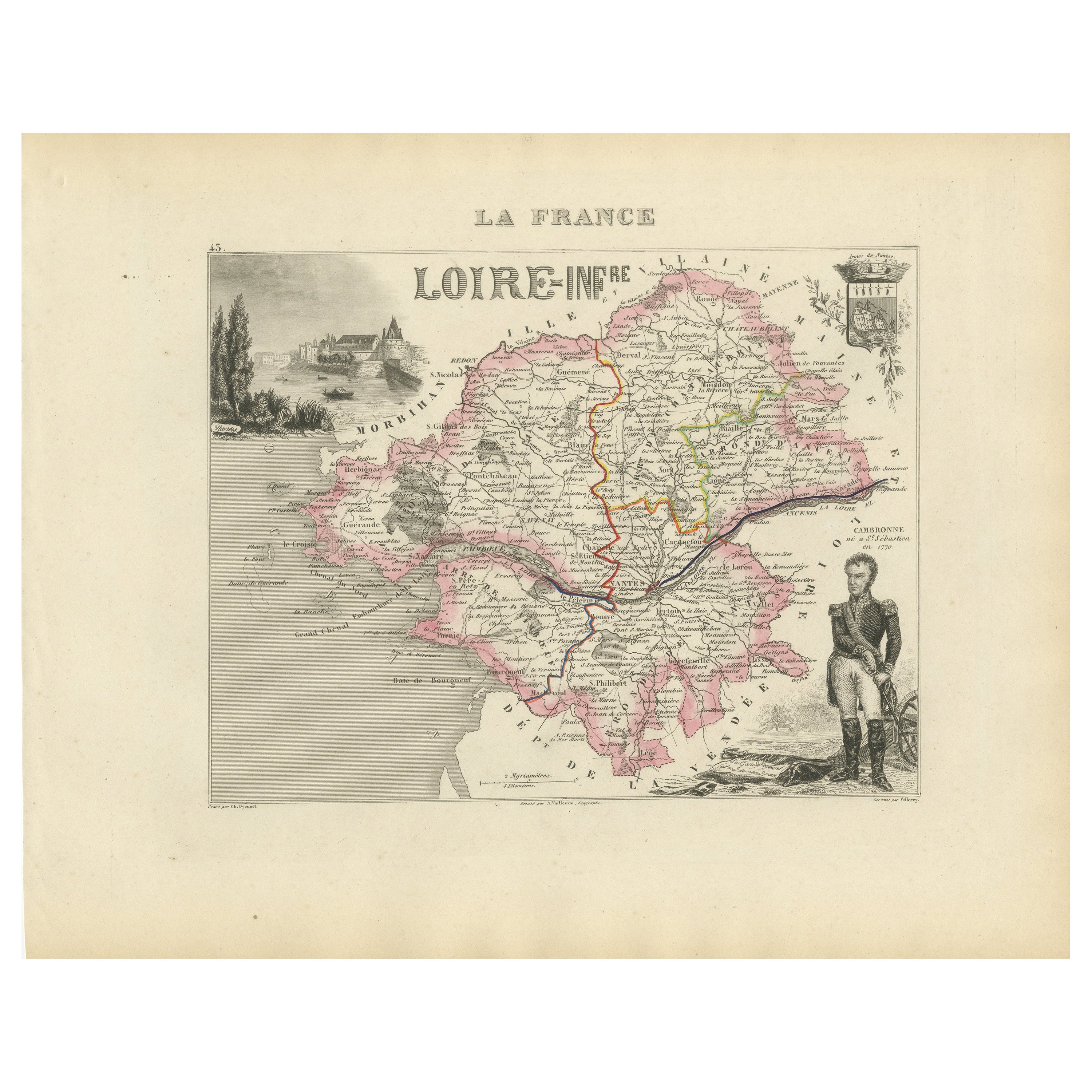
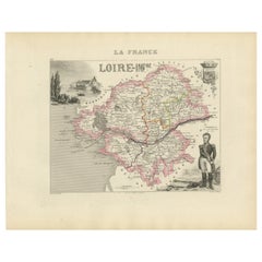
Map of Loire-Inférieure France with Nantes and Estuary by Vuillemin, 19th c
Located in Langweer, NL
Map of Loire-Inférieure France with Nantes and Estuary by Vuillemin, 19th c
This finely engraved and hand-colored map of Loire-Inférieure (modern-day Loire-Atlantique) was created b...
Category
Antique Mid-19th Century French Maps
Materials
Paper
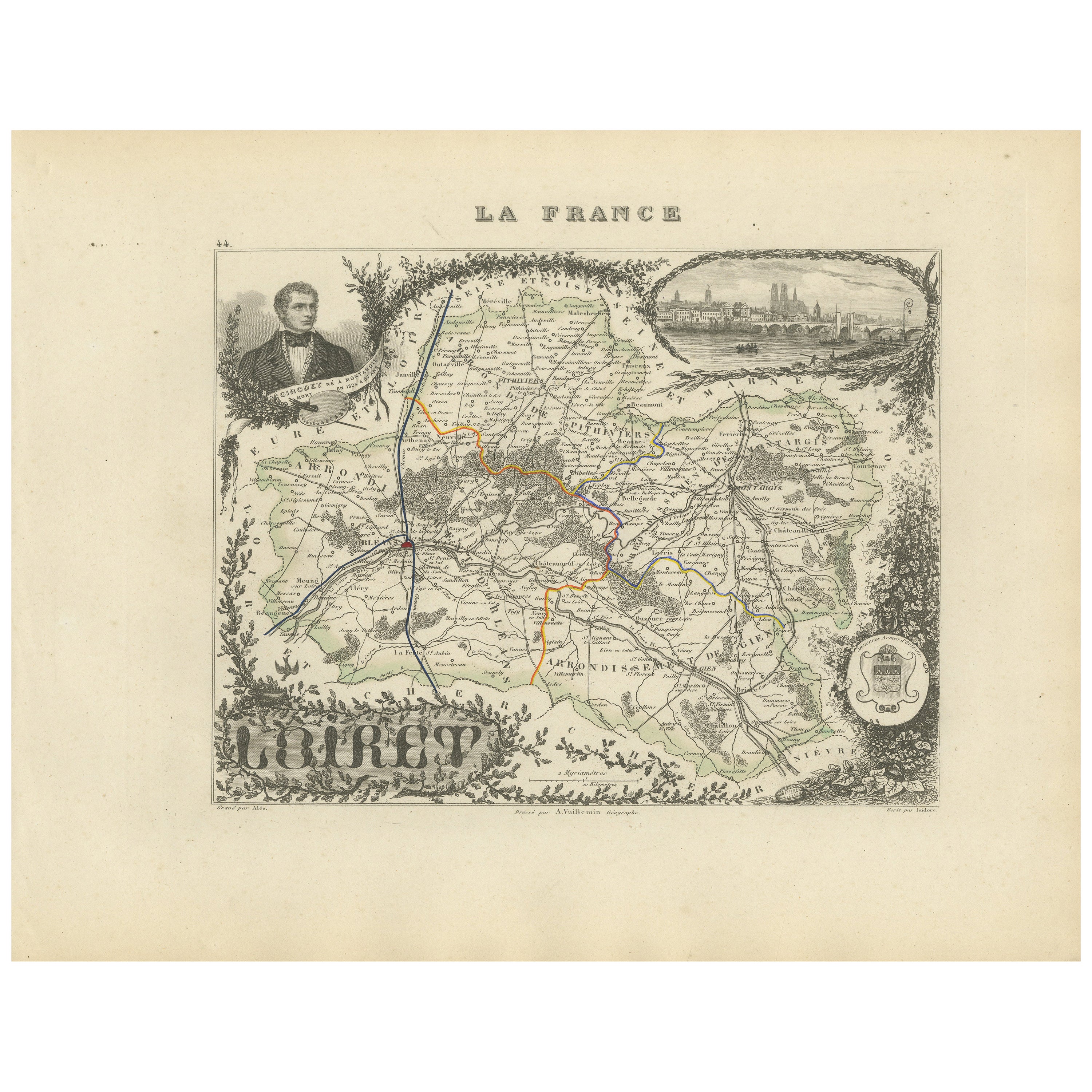
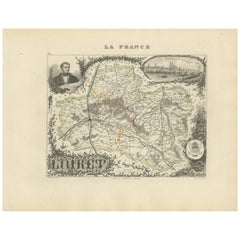
Map of Loiret France with Orléans and Loire River by Vuillemin, 19th c
Located in Langweer, NL
Map of Loiret France with Orléans and Loire River by Vuillemin, 19th c
This antique hand-colored map of the Loiret department, engraved by Alexandre Vuillemin and published by Migeo...
Category
Antique Mid-19th Century French Maps
Materials
Paper
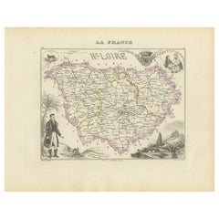
Map of Loire France with Saint-Étienne and Montbrison by Vuillemin, 19th c
Located in Langweer, NL
Map of Loire France with Saint-Étienne and Montbrison by Vuillemin, 19th c
This beautifully engraved and hand-colored map of the department of Loire in east-central France is from t...
Category
Antique Mid-19th Century French Maps
Materials
Paper

Map of Côtes-du-Nord France with Saint-Brieuc and Brittany Coastline, c.1850
Located in Langweer, NL
Map of Côtes-du-Nord France with Saint-Brieuc and Brittany Coastline, 19th c
Description:
This elegant 19th-century map of Côtes-du-Nord, the historic name for what is now known as ...
Category
Antique Mid-19th Century French Maps
Materials
Paper

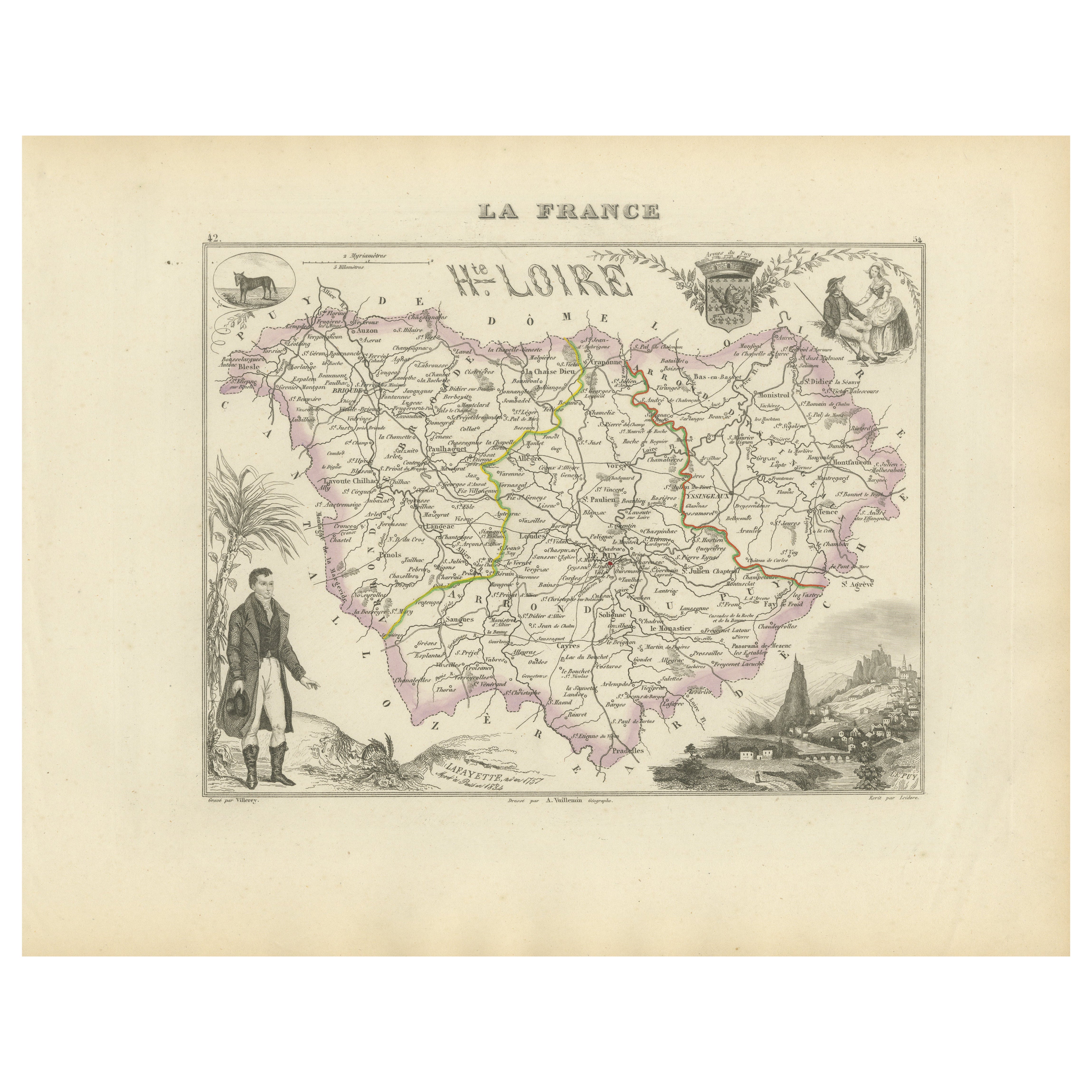
Map of Haute-Loire France with Le Puy-en-Velay by Vuillemin, 19th c
Located in Langweer, NL
Map of Haute-Loire France with Le Puy-en-Velay by Vuillemin, 19th c
This 19th-century hand-colored map of the Haute-Loire department in south-central France is from Alexandre Vuille...
Category
Antique Mid-19th Century French Maps
Materials
Paper
You May Also Like
Loir and Cher, France. Antique map of a French department, 1856
By Victor Levasseur
Located in Melbourne, Victoria
'Dept. de Loir and Cher', steel engraving with original outline hand-colouring., 1856, from Levasseur's Atlas National Illustre.
This area is mainly known for its production of Sel...
Category
19th Century Naturalistic Landscape Prints
Materials
Engraving
Saone and Loire, France. Antique map of a French department, 1856
By Victor Levasseur
Located in Melbourne, Victoria
'Dept. de Saone et Loire', steel engraving with original outline hand-colouring., 1856, from Levasseur's Atlas National Illustre.
The French department of Saone et Loire is at the ...
Category
19th Century Naturalistic Landscape Prints
Materials
Engraving

Large 19th Century Map of France
Located in Pease pottage, West Sussex
Large 19th Century Map of France.
Remarkable condition, with a pleasing age worn patina.
Recently framed.
France Circa 1874.
Category
Antique Late 19th Century French Maps
Materials
Linen, Paper

L
Isere, France. Antique map of French department, 1856
By Victor Levasseur
Located in Melbourne, Victoria
'Dept. de L'Isere', Steel engraving with original outline hand-colouring., 1856, from Levasseur's 'Atlas National Illustre'.
This area is known for its production of Bleu du Vercor...
Category
19th Century Naturalistic Landscape Prints
Materials
Engraving

Indre and Loire, France. Antique map of a French department, 1856
By Victor Levasseur
Located in Melbourne, Victoria
'Dept. d'Indre et Loire', steel engraving with original outline hand-colouring., 1856, from Levasseur's 'Atlas National Illustre'.
This area is known for its production of Chenin b...
Category
19th Century Naturalistic Landscape Prints
Materials
Engraving

Aube, France. Antique map of a French department, 1856
By Victor Levasseur
Located in Melbourne, Victoria
'Dept. de L'Aube', steel engraving with original outline hand-colouring., 1856, from Levasseur's 'Atlas National Illustre'.
This area of France is known for its production of Chaou...
Category
19th Century Naturalistic Landscape Prints
Materials
Engraving
