Items Similar to Africa Map with Egypt
South Africa Insets – Nieuwe Hand-Atlas, 1876


Want more images or videos?
Request additional images or videos from the seller
1 of 10
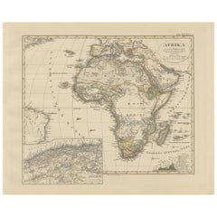
Africa Map with Egypt
South Africa Insets – Nieuwe Hand-Atlas, 1876
$415.29
£310.04
€350
CA$576.97
A$620.61
CHF 331.67
MX$7,315.27
NOK 4,181.63
SEK 3,822.81
DKK 2,667.39
About the Item
Africa Map with Egypt
South Africa Insets – Nieuwe Hand-Atlas, 1876
This 19th-century map titled “Afrika,” published in 1876 in the Nieuwe Hand-Atlas der Aarde in haren Tegenwoordigen Toestand by M. Frijlink and revised by A. van Otterloo, offers a rich and meticulous depiction of the African continent at a historical turning point. Printed in Leiden by D. Noothoven van Goor, the plate captures Africa before the full-scale colonial partitioning that followed in the late 19th century, making it an important pre–Scramble for Africa document.
The map presents the entire continent, from the Mediterranean basin to the Cape of Good Hope, and from the Atlantic shores to the Indian Ocean. Much of the interior is still described through exploratory notes, reflecting the period when European expeditions were mapping the Nile sources, the Congo basin, the Zambezi valley, and the great lakes of East Africa. Prominent mountain systems such as the Atlas, the Ethiopian Highlands, and the legendary Mountains of the Moon are finely engraved. Major rivers including the Nile, Congo, Niger, Senegal, Orange, and Zambezi are clearly drawn, offering a clear view of the continent’s major hydrological systems.
Political regions are outlined in soft hand-colored borders, identifying major territories as they appeared in the mid-19th century: Egypt under the Khedive, Abyssinia (Ethiopia), the regencies of North Africa, the Sultanate of Zanzibar along the East African coast, and the Boer republics in the south. Because these borders predate the formal European colonial carve-up, the map is of significant historical value to collectors and scholars.
The plate includes multiple inset maps that add context and detail. These include a map of North Africa emphasizing French Algeria, a detailed map of South Africa showing the Cape Colony, Natal, Orange Free State, and the Transvaal, and an inset of West Africa along the Guinea Coast, showing key trading and missionary areas. There is also a finely engraved plan of Cape Town’s harbor, demonstrating its strategic maritime importance.
This map offers a rare and comprehensive view of Africa just as the continent was beginning to enter its most dramatic phase of geopolitical transformation. The engraving is crisp, the typography elegant, and the soft hand-coloring adds visual warmth typical of high-quality Dutch atlas production.
Condition report:
Good condition with light toning and scattered foxing near the margins. Original center fold as issued. The printed image is sharp with clean linework and well-preserved hand-coloring. No tears, repairs, or significant defects.
Framing tips:
A warm ivory or cream mat pairs well with the soft color palette. A black, dark walnut, or mahogany frame adds contrast and elegance. Because of the many inset maps, a slightly wider mat margin enhances balance and readability. Suitable for libraries, home offices, and interiors dedicated to exploration or African history.
Keyword block:
Africa, North Africa, West Africa, East Africa, Central Africa, Southern Africa, Egypt, Nubia, Abyssinia, Ethiopia, Sudan, Sahara, Algeria, Tunisia, Morocco, Tripoli, Senegambia, Guinea Coast, Gold Coast, Congo, Angola, Mozambique, Zanzibar, Madagascar, Cape Colony, Natal, Transvaal, Orange Free State, Cape Town, Nile River, Congo River, Niger River, Zambezi, Great Lakes of Africa, Lake Victoria, Lake Tanganyika, explorers routes, 19th century Africa map, pre-Scramble for Africa, 1876 Africa map, Nieuwe Hand-Atlas.
- Dimensions:Height: 17.33 in (44 cm)Width: 21.66 in (55 cm)Depth: 0.01 in (0.2 mm)
- Materials and Techniques:
- Place of Origin:
- Period:
- Date of Manufacture:1876
- Condition:Good condition with light toning and scattered foxing near the margins. Original center fold as issued. The printed image is sharp with clean linework and well-preserved hand-coloring. No tears, repairs, or significant defects.
- Seller Location:Langweer, NL
- Reference Number:Seller: BG-12788-261stDibs: LU3054347571132
About the Seller
5.0
Recognized Seller
These prestigious sellers are industry leaders and represent the highest echelon for item quality and design.
Platinum Seller
Premium sellers with a 4.7+ rating and 24-hour response times
Established in 2009
1stDibs seller since 2017
2,836 sales on 1stDibs
Typical response time: 1 hour
- ShippingRetrieving quote...Shipping from: Langweer, Netherlands
- Return Policy
More From This Seller
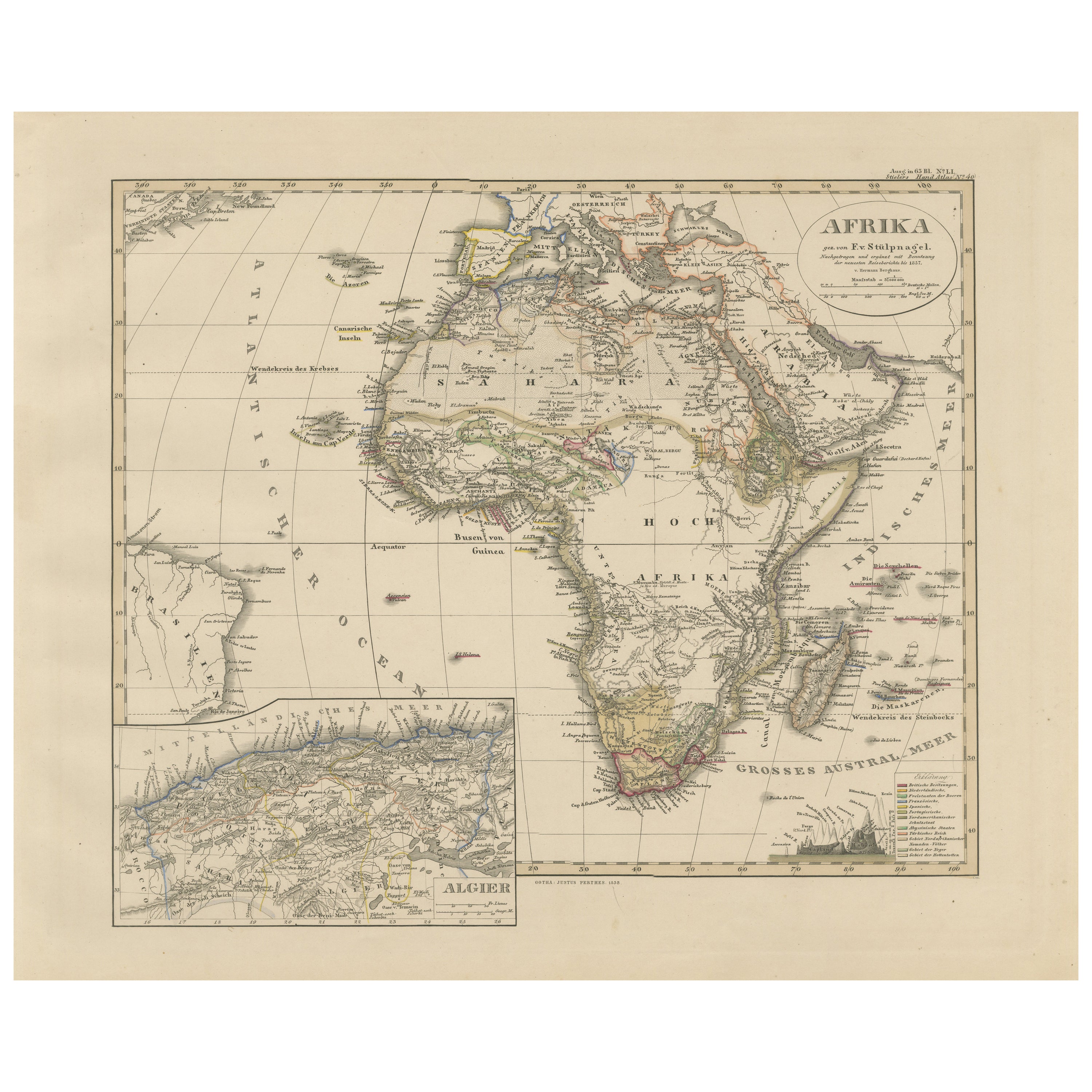
View AllColorfull Antique Map of Africa with Algeria Inset – Stieler Atlas 1858
Located in Langweer, NL
Antique Map of Africa with Algeria Inset – Stieler Atlas 1858
This antique map of Africa, engraved by F. von Stülpnagel and published by Justus Perthes in 1858, is a finely detailed...
Category
Antique Mid-19th Century German Maps
Materials
Paper
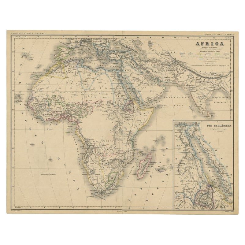
Antique Map of the African Continent with Inset of the Nile River Delta, c.1870
Located in Langweer, NL
Antique map titled 'Africa'. Old map of the African continent. This map originates from 'H. Kiepert's Kleiner Atlas der Neueren Geographie für Schule...
Category
Antique 19th Century Maps
Materials
Paper

$303 Sale Price
20% Off
Antique Map of Africa, Highlighting Colonial Divisions, Geographic Features 1903
Located in Langweer, NL
Title: Antique Map of Africa, 1903, Highlighting Colonial Divisions and Geographic Features
Description: This antique map, titled "Africa," was engraved and published in 1903 by W. ...
Category
Early 20th Century Maps
Materials
Paper

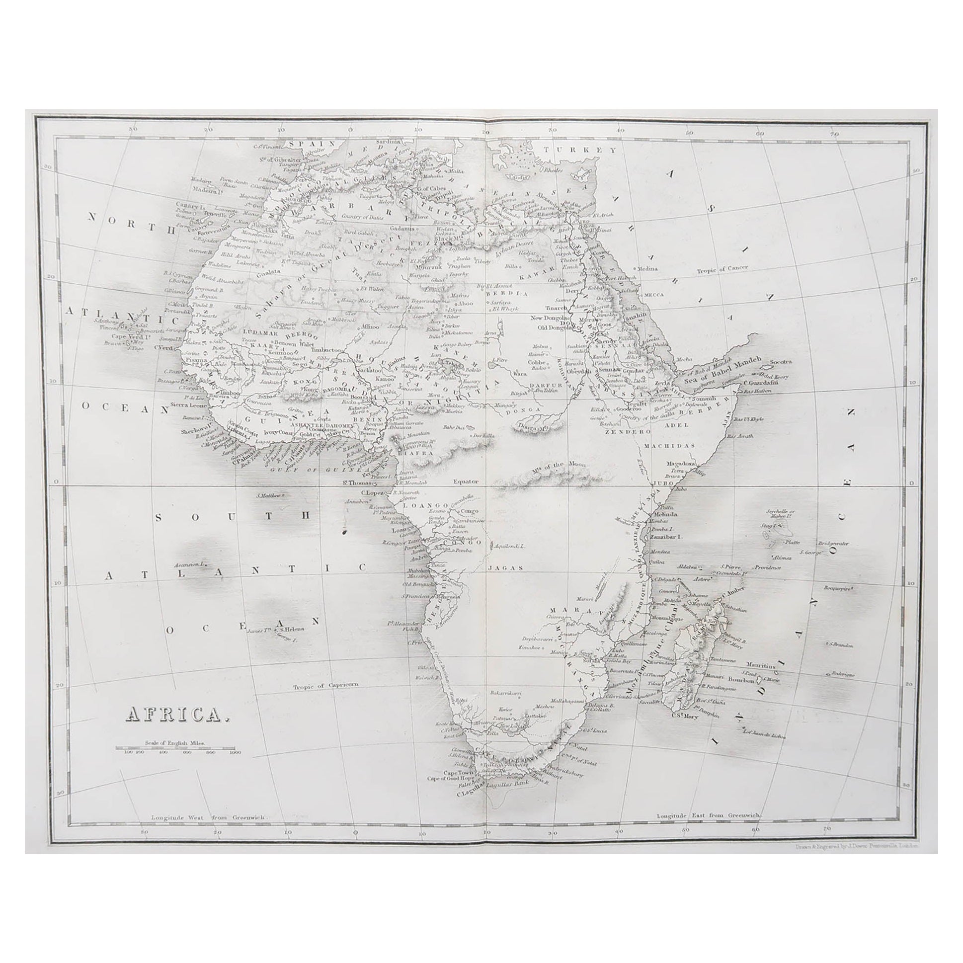
Antique Map of Africa by A
C, Black, 1870
Located in Langweer, NL
Antique map titled 'Africa'. Original antique map of Africa. This map originates from ‘Black's General Atlas of The World’. Published by A & C. Black, 1870.
Category
Antique Late 19th Century Maps
Materials
Paper

$261 Sale Price
20% Off
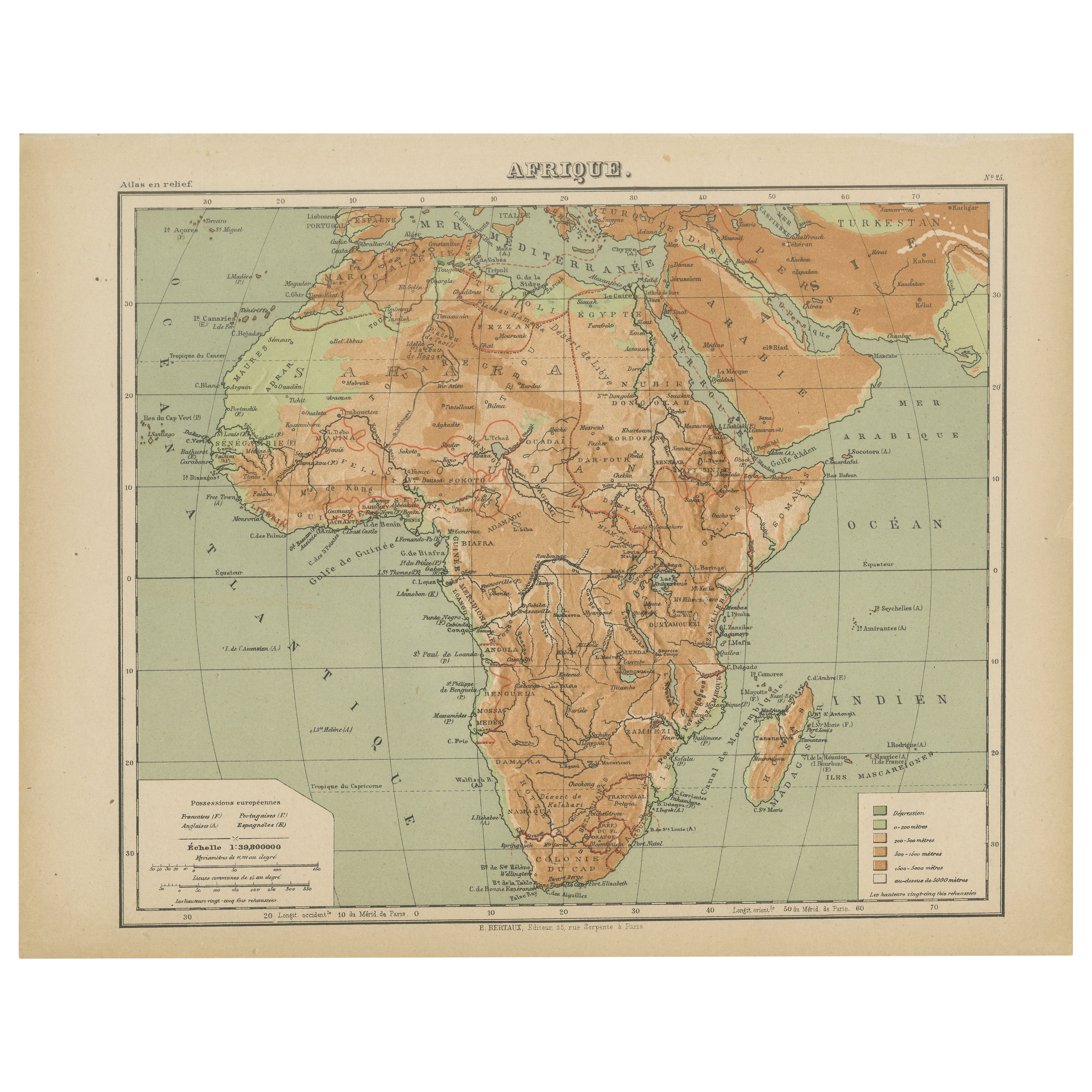
Relief Atlas Map of Africa by Hachette – Antique c.1883 French Map
Located in Langweer, NL
Antique Map of Africa – Relief Atlas Map by Hachette, circa 1880
Description:
This is an attractive antique map titled “Afrique,” published by Hachette...
Category
Antique Late 19th Century Maps
Materials
Paper
Antique Map of Africa with European Language Borders, 1852
Located in Langweer, NL
Antique map titled 'Afrika'. Map of Africa. This map originates from 'School-Atlas van alle deelen der Aarde' by Otto Petri.
Artists and Engravers: Published by A. Baedeker (Otto...
Category
Antique 19th Century Maps
Materials
Paper

You May Also Like
Original Antique Map of Africa by Dower, circa 1835
Located in St Annes, Lancashire
Nice map of Africa
Drawn and engraved by J.Dower
Published by Orr & Smith. C.1835
Unframed.
Free shipping
Category
Antique 1830s English Maps
Materials
Paper

Africa. North-East Part. Century Atlas antique vintage map
Located in Melbourne, Victoria
'The Century Atlas. Africa. North-East Part'
Original antique map, 1903.
Inset map of 'Nile Delta and Suez Canal'.
Central fold as issued. Map name and nu...
Category
Early 20th Century Victorian More Prints
Materials
Lithograph

Africa. Central. Century Atlas antique vintage map
Located in Melbourne, Victoria
'The Century Atlas. Africa. Central'
Inset map of 'Madagascar'.
Original antique map, 1903.
Central fold as issued. Map name and number printed on the reverse corners.
Sheet 29.5cm...
Category
Early 20th Century Victorian More Prints
Materials
Lithograph

Africa. Southern Part. Century Atlas antique vintage map
Located in Melbourne, Victoria
'The Century Atlas. Africa. Southern Part'
Original antique map, 1903.
Inset maps of 'Cape Town', 'Johannesburg' and 'Ladysmith'.
Central fold as issued. Map name and number printe...
Category
Early 20th Century Victorian More Prints
Materials
Lithograph

Africa. North-West Part. Century Atlas antique vintage map
Located in Melbourne, Victoria
'The Century Atlas. Africa. Southern Part'
Original antique map, 1903.
Central fold as issued. Map name and number printed on the reverse corners.
Sheet 40cm by 29.5cm.
Category
Early 20th Century Victorian More Prints
Materials
Lithograph

Large Original Antique Map of Africa. C.1900
Located in St Annes, Lancashire
Fabulous map of Africa
Original color.
Engraved and printed by the George F. Cram Company, Indianapolis.
Published, C.1900.
Unframed.
Free shipping.
Category
Antique 1890s American Maps
Materials
Paper
