Items Similar to Almería 1901: Coastal Contours and Landscapes in a Map of Southeastern Spain


Want more images or videos?
Request additional images or videos from the seller
1 of 8
Almería 1901: Coastal Contours and Landscapes in a Map of Southeastern Spain
$306.65
$383.3120% Off
£229.30
£286.6320% Off
€256
€32020% Off
CA$422.48
CA$528.1020% Off
A$460.78
A$575.9720% Off
CHF 244.09
CHF 305.1120% Off
MX$5,524.05
MX$6,905.0620% Off
NOK 3,108.60
NOK 3,885.7420% Off
SEK 2,842.58
SEK 3,553.2220% Off
DKK 1,950.82
DKK 2,438.5320% Off
About the Item
An original antique map of the province of Almería, Spain, from the year 1901.
The Mediterranean Sea, labeled as "Mar Mediterraneo," forms the southeastern boundary of the province, with coastlines and port locations indicated.
The coat of arms of Almería is prominently displayed, incorporating the castle and the cross, which are historic symbols often associated with the Reconquista period in Spain.
Almería is a province located in the southeastern part of Spain, within the autonomous community of Andalusia. It shares its borders with the provinces of Granada and Murcia and has a significant coastline along the Mediterranean Sea. Here are some notable aspects of Almería:
The capital, also called Almería, is a historic city with a rich history dating back to the times when it was an important harbor in the Caliphate of Córdoba, and later, a stronghold during the Reconquista.
The province enjoys a semi-arid to arid climate, making it one of the driest regions in Europe. This climate is conducive to the large-scale production of fruits and vegetables, often under vast plastic greenhouses, a practice that has given the region the nickname "The Sea of Plastic."
Aside from agriculture, the economy of Almería also benefits from marble quarrying and export, as well as from tourism, especially along its coastal areas known as the Costa de Almería.
Cabo de Gata-Níjar Natural Park: This park is a UNESCO Biosphere Reserve and is known for its volcanic rock formations, diverse marine life, and some of the most untouched beaches in Spain.
Almería has a long history with the film industry, serving as the location for many famous films, especially Westerns, in the 1960s and 1970s. The desert-like landscapes of the Tabernas Desert have been a favored backdrop for many filmmakers.
The province has a rich Moorish heritage, which is visible in its architecture and cultural festivals. The Alcazaba of Almería, a medieval fortress, is a prominent historical monument in the capital city.
The province is a leader in intensive agriculture, particularly for the European market, with advanced techniques in water management and crop production.
Almería is also home to the largest concentration of greenhouses in the world and has made significant strides in solar energy research and development, hosting the largest solar research center in Europe.
Almería's blend of ancient history, unique landscapes, and modern agricultural techniques make it a diverse and interesting region of Spain.
- Dimensions:Height: 14.77 in (37.5 cm)Width: 20.08 in (51 cm)Depth: 0 in (0.02 mm)
- Materials and Techniques:
- Period:1900-1909
- Date of Manufacture:1901
- Condition:Good condition. Central vertical folding lines as issued. Aged paper with typically warm, yellowish-brown hue, especially around the edges. Part of the folding line is brown, adding to its patina -check the images carefully.
- Seller Location:Langweer, NL
- Reference Number:Seller: BG-13642-41stDibs: LU3054338031432
About the Seller
5.0
Recognized Seller
These prestigious sellers are industry leaders and represent the highest echelon for item quality and design.
Platinum Seller
Premium sellers with a 4.7+ rating and 24-hour response times
Established in 2009
1stDibs seller since 2017
2,791 sales on 1stDibs
Typical response time: <1 hour
- ShippingRetrieving quote...Shipping from: Langweer, Netherlands
- Return Policy
More From This Seller
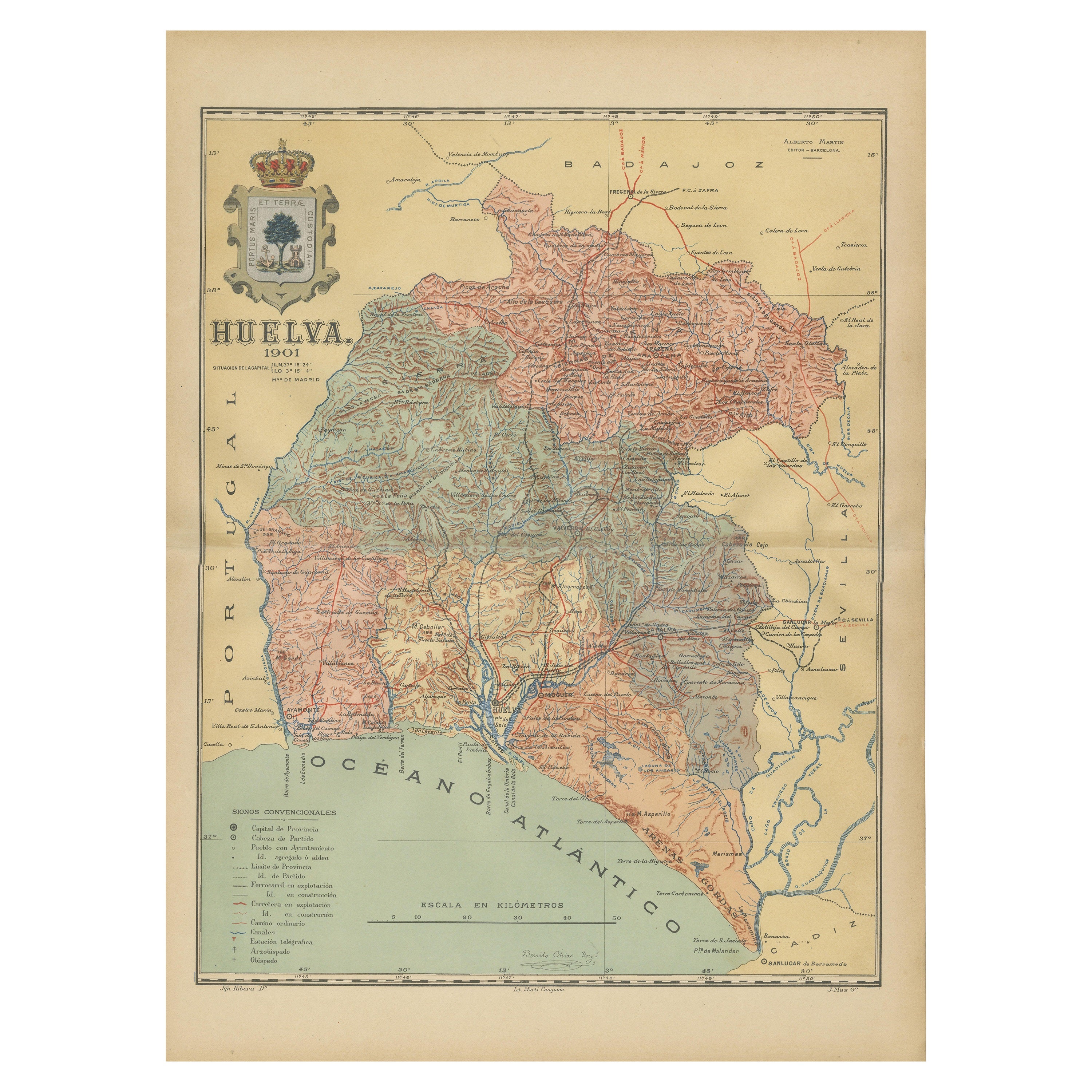
View AllHuelva 1901: A Cartographic Presentation of Andalusia
s Atlantic Frontier
Located in Langweer, NL
The map displays the province of Huelva, located in the southwestern part of the autonomous community of Andalusia in Spain, as of the year 1901. It outlines various geographic and m...
Category
Antique Early 1900s Maps
Materials
Paper

$344 Sale Price
20% Off
Free Shipping
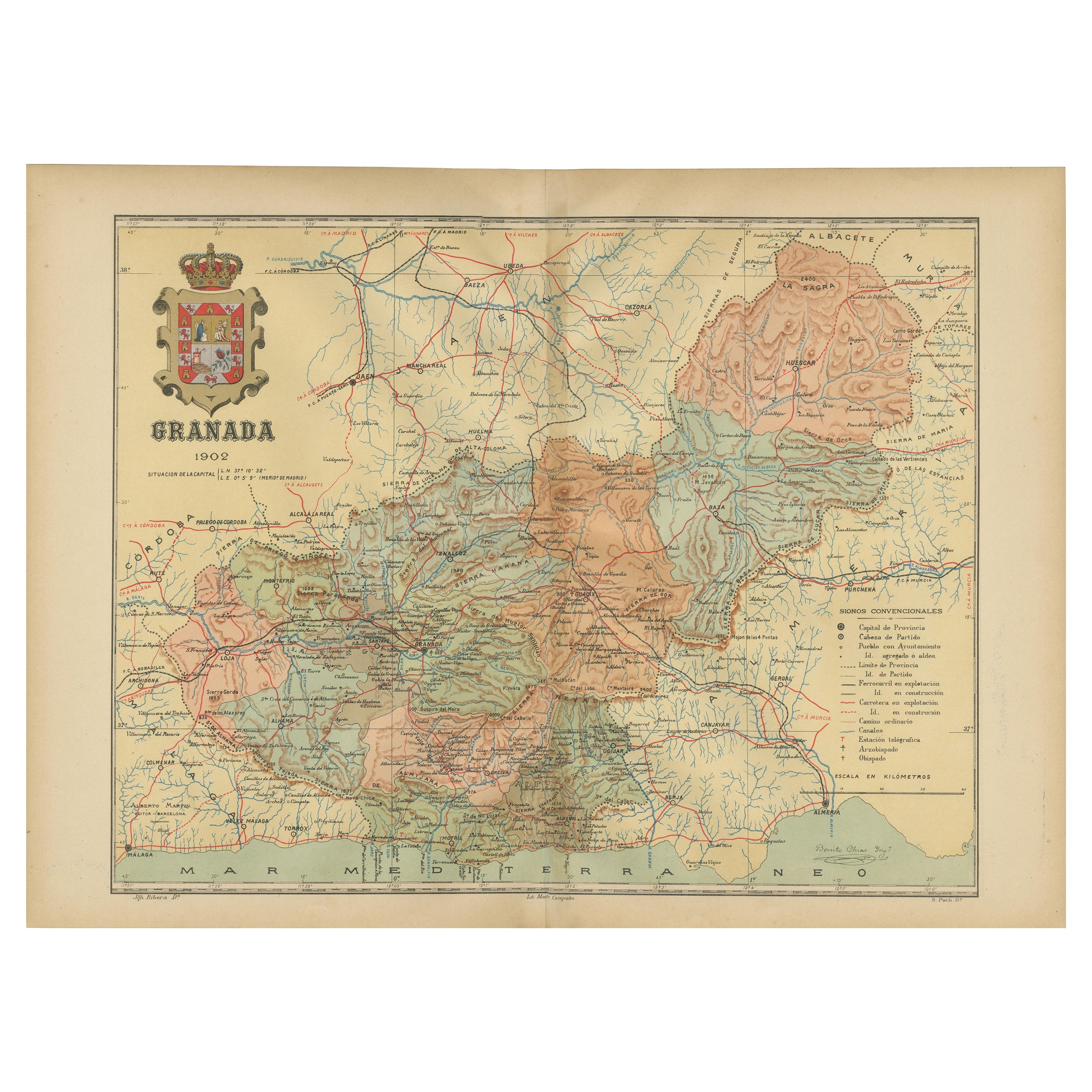
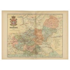
Granada 1902: A Cartographic Exploration of Andalusia
s Mountainous Province
Located in Langweer, NL
This original antique map depicts the province of Granada, part of the autonomous community of Andalusia in southern Spain, as of 1902. The map features several important details:
I...
Category
Antique Early 1900s Maps
Materials
Paper
$373 Sale Price
20% Off
Free Shipping
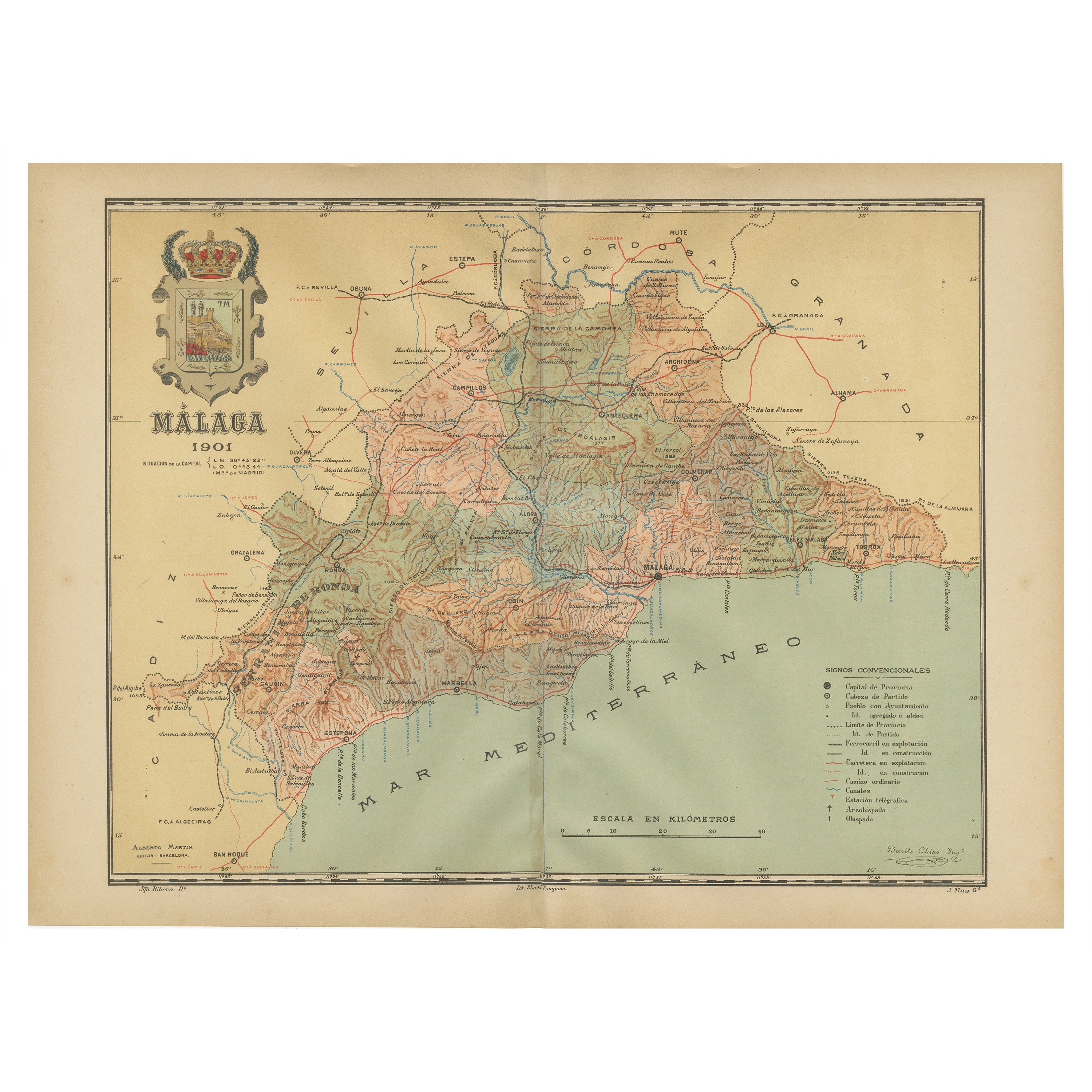
Málaga 1901: A Cartographic Detailing of Andalusia
s Coastal Jewel
Located in Langweer, NL
The map depicts the province of Málaga, located in the autonomous community of Andalusia in southern Spain, as it was in 1901. Here are the key features illustrated on the map:
- **...
Category
Antique Early 1900s Maps
Materials
Paper

$325 Sale Price
20% Off
Free Shipping
Topographical and Infrastructure Map of the Province of Valencia, 1901
Located in Langweer, NL
A historical map of the province of Valencia, dated 1901. The map includes intricate details such as topographical features, with mountain ranges and river systems prominently marked...
Category
Antique Early 1900s Maps
Materials
Paper

$498 Sale Price
20% Off
Free Shipping
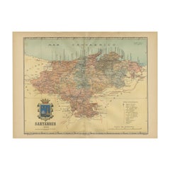
Maritime and Terrestrial Survey of Spanish Santander in 1901, An Original Map
Located in Langweer, NL
This antique map is a historical map of the province of Santander (currently known as Cantabria) from the year 1901. Santander is located along the northern coast of Spain, bordering...
Category
Antique Early 1900s Maps
Materials
Paper
$277 Sale Price
20% Off
Free Shipping
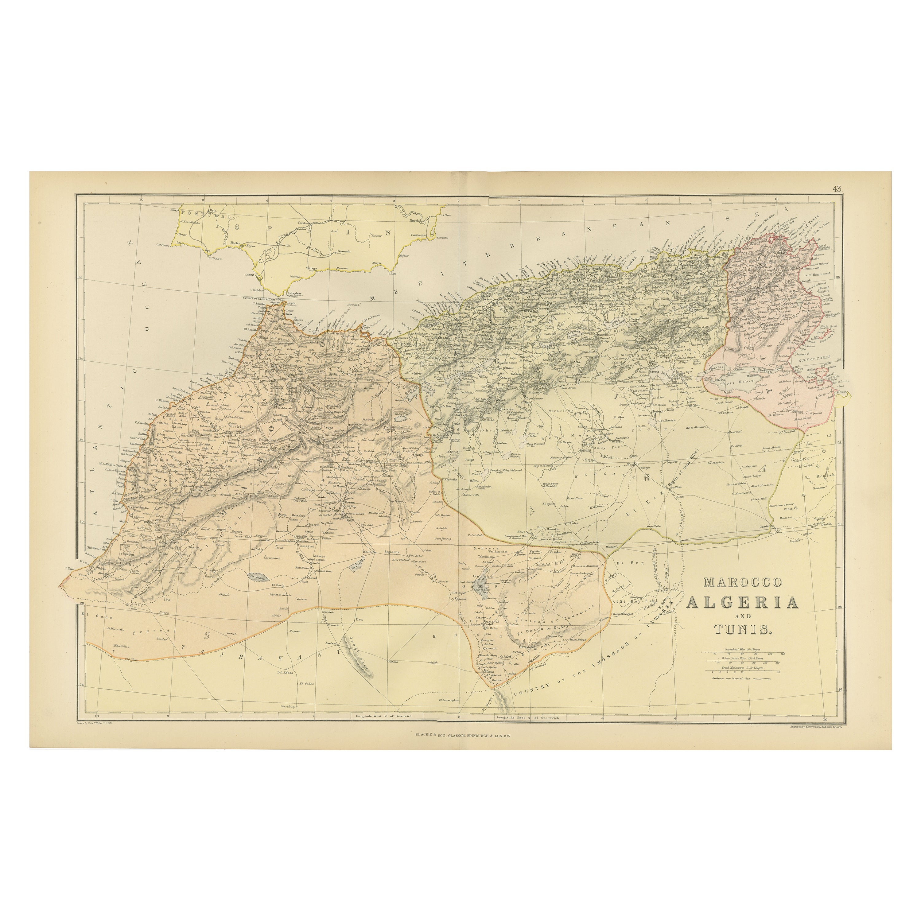
Antique Decorative Coloured Map Marocco, Algeria and Tunis, 1882
Located in Langweer, NL
The maps is from the 1882 atlas by Blackie
Son and offers a detailed view of the North African regions as understood in the late 19th century.
**Map of Morocco, Algeria, and...
Category
Antique 1880s British Maps
Materials
Paper

You May Also Like
Large Original Antique Map of Cyprus. 1894
Located in St Annes, Lancashire
Superb Antique map of Cyprus
Published Edward Stanford, Charing Cross, London 1894
Original colour
Good condition
Unframed.
Free shipping
Category
Antique 1890s English Maps
Materials
Paper

Large Original Vintage Map of Spain, circa 1920
Located in St Annes, Lancashire
Great map of Spain
Original color.
Good condition
Published by Alexander Gross
Unframed.
Category
Vintage 1920s English Maps
Materials
Paper

Large Original Antique Map of The Canary Islands. 1894
Located in St Annes, Lancashire
Superb Antique map of The Canary Islands
Published Edward Stanford, Charing Cross, London 1894
Original colour
Good condition
Unframed.
Free shipping
Category
Antique 1890s English Maps
Materials
Paper

Large Original Antique Map of Madeira. 1894
Located in St Annes, Lancashire
Superb Antique map of Madeira
Published Edward Stanford, Charing Cross, London 1894
Original colour
Good condition
Unframed.
Free shipping
Category
Antique 1890s English Maps
Materials
Paper

Africa. North-West Part. Century Atlas antique vintage map
Located in Melbourne, Victoria
'The Century Atlas. Africa. Southern Part'
Original antique map, 1903.
Central fold as issued. Map name and number printed on the reverse corners.
Sheet 40cm by 29.5cm.
Category
Early 20th Century Victorian More Prints
Materials
Lithograph

Large Original Antique Map of Afghanistan. Edward Weller, 1861
Located in St Annes, Lancashire
Great map of Afghanistan
Lithograph engraving by Edward Weller
Original colour
Published, 1861
Unframed
Good condition
Category
Antique 1860s English Victorian Maps
Materials
Paper

More Ways To Browse
Antique Greenhouse
Stretcher Tables
M Table
Antique Sultanabad Carpets
China Chair
English Antique Desks
Used Beige Sofa
Antique Plate Germany
Hand Tufted Rugs
Rare China
Side Table Made In Denmark
Thonet Antique
Victorian Hall Tables
Vintage Computer
England Antique Plates
19th Century Round Dining Table
Antique Counters
Antique Thrones