Items Similar to Antique Asia Map – Large 19th-Century Engraving with Political Boundaries, 1865


Want more images or videos?
Request additional images or videos from the seller
1 of 10
Antique Asia Map – Large 19th-Century Engraving with Political Boundaries, 1865
$466.69
£348.57
€390
CA$642.95
A$700.70
CHF 371.05
MX$8,416.19
NOK 4,697.61
SEK 4,318.99
DKK 2,971.13
About the Item
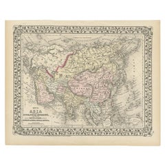
Antique Map of Asia – Andriveau-Goujon, Paris 1865
This large and finely engraved antique map titled “Asie” was published in Paris in 1865 by the prominent French cartographer E. Andriveau-Goujon. Issued as plate number 33 from the *Atlas Universel*, it presents the continent of Asia in its entirety, extending from the Mediterranean and Middle East to the Pacific Ocean, and from the Arctic Ocean down to the islands of Southeast Asia and the Indian Ocean.
The map shows the vast expanse of Asia divided into major regions and empires of the time. The Russian Empire dominates the north, shaded in light green, stretching across Siberia and into Central Asia. China is clearly outlined and labeled as “Empire de la Chine,” while India, shown in pink, is marked as “Empire de l’Inde,” reflecting its status under British colonial control. Other territories such as Persia (Iran), the Ottoman provinces in Asia, Afghanistan, Siam (Thailand), Korea, and Japan are distinctly marked and shaded.
Major cities including Peking (Beijing), Calcutta, Bombay, Delhi, Kabul, Mecca, Tehran, Tokyo (referred to as Yedo), and others are labeled. Mountain ranges, deserts, river systems, and key trade routes are finely engraved, adding geographical depth to the political boundaries.
A legend in the lower left corner explains the color-coding of empires and political entities, as well as the symbols for capitals, fortresses, ports, and trade centers. This map reflects the geopolitical landscape of Asia during a period of colonial expansion, imperial rivalry, and increased European interest in Asia’s strategic and commercial importance.
Condition: Very good condition. Original centerfold as issued. Light age toning and minimal foxing to the margins. Strong impression with well-preserved original hand coloring. Plate number 33 in upper right.
Framing tips: Best presented in a dark wood or black frame with a wide ivory mat. A secondary mat in soft green or gold can enhance the pastel tones and period character.
Technique: Engraving with original hand coloring
Maker: E. Andriveau-Goujon, Paris, 1865
- Dimensions:Height: 20.91 in (53.1 cm)Width: 27.64 in (70.2 cm)Depth: 0.01 in (0.2 mm)
- Materials and Techniques:Paper,Engraved
- Place of Origin:
- Period:
- Date of Manufacture:1865
- Condition:Condition: Very good condition. Original centerfold as issued. Light age toning and minimal foxing to the margins. Strong impression with well-preserved original hand coloring. Plate number 33 in upper right.
- Seller Location:Langweer, NL
- Reference Number:Seller: BG-14099-131stDibs: LU3054346186042
About the Seller
5.0
Recognized Seller
These prestigious sellers are industry leaders and represent the highest echelon for item quality and design.
Platinum Seller
Premium sellers with a 4.7+ rating and 24-hour response times
Established in 2009
1stDibs seller since 2017
2,788 sales on 1stDibs
Typical response time: <1 hour
- ShippingRetrieving quote...Shipping from: Langweer, Netherlands
- Return Policy
More From This Seller
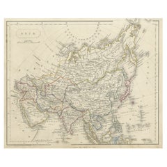
View AllAntique Map of Asia by A
C, Black, 1870
Located in Langweer, NL
Antique map titled 'Asia'. Original antique map of Asia. This map originates from ‘Black's General Atlas of The World’. Published by A & C. Black, 1870.
Category
Antique Late 19th Century Maps
Materials
Paper

$239 Sale Price
20% Off
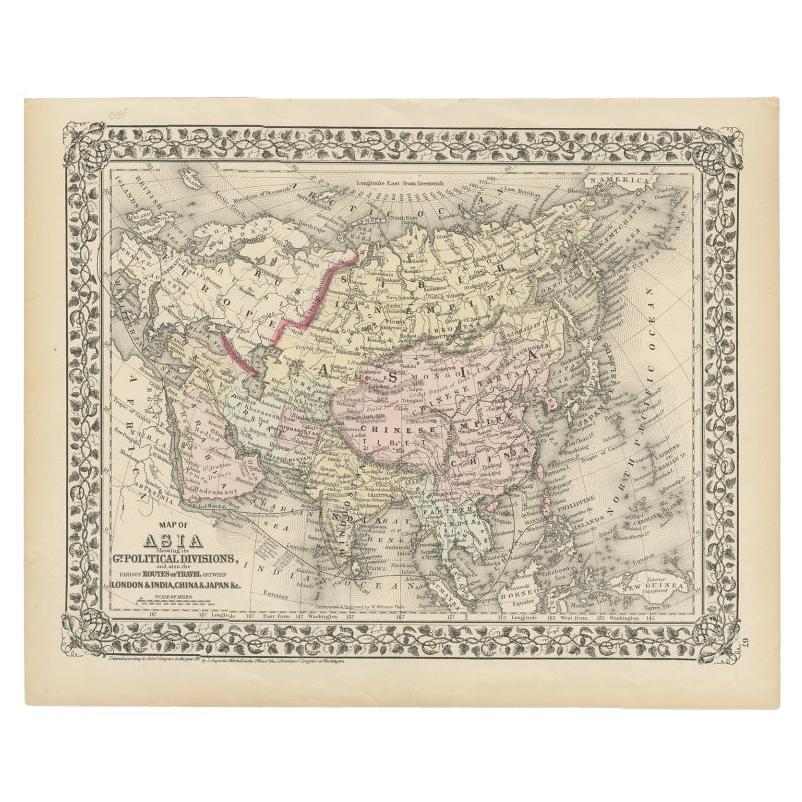
Antique Map of Asia Showing Its Political Divisions, 1874
Located in Langweer, NL
Antique map titled 'Map of Asia showing its Gt. Political Divisions and also the various routes of Travel between London & India, China & Japan & c'. This map covers from the Arabian...
Category
Antique 19th Century Maps
Materials
Paper
Antique Map of Asia by Young, c.1860
Located in Langweer, NL
Antique map titled 'Asia'. Steel engraved map of Asia by Francis Young.
Artists and Engravers: Engraved by Lewis Becker. Published by S.O. Beeton.
We sell original antique maps to...
Category
Antique 19th Century Maps
Materials
Paper

Antique Map of Asia from a German School Atlas, c.1870
Located in Langweer, NL
Antique map titled 'Asien'. Old map of the Asian continent. This map originates from 'H. Kiepert's Kleiner Atlas der Neueren Geographie für Schule und Haus'.
Artists and Engravers:...
Category
Antique 19th Century Maps
Materials
Paper

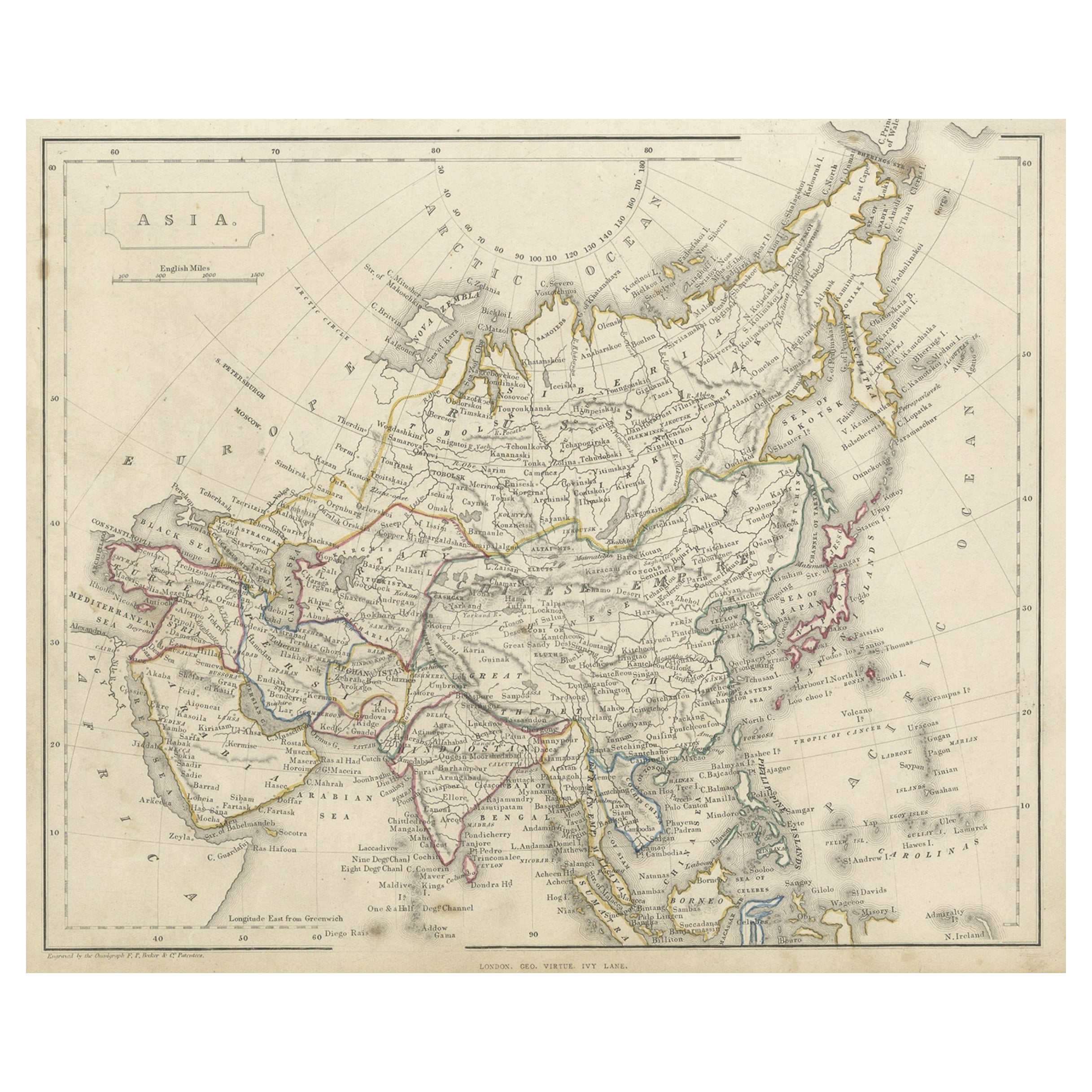
Antique Steel Engraved Map of Asia, c.1860
Located in Langweer, NL
Antique map titled 'Asia'. Steel engraved map of Asia by F. P. Becker & Co.
Artists and Engravers: Engraved by F.P. Becker & Co. Published in London.
Condition: Very good, gen...
Category
Antique 19th Century Maps
Materials
Paper
Antique Map of Asia by K. Johnston, circa 1879
Located in Langweer, NL
No. 28 of Keith Johnston's General Atlas. Published by William Blackwood & Sons Edinburgh & London, circa 1879.
Category
Antique Late 19th Century Maps
Materials
Paper

You May Also Like
Large Original Antique Map of Asia by Sidney Hall, 1847
Located in St Annes, Lancashire
Great map of Asia
Drawn and engraved by Sidney Hall
Steel engraving
Original colour outline
Published by A & C Black. 1847
Unframed
Free shipping
Category
Antique 1840s Scottish Maps
Materials
Paper

Original Antique Map of The Eastern Hemisphere by Dower, circa 1835
Located in St Annes, Lancashire
Nice map of the Eastern Hemisphere
Drawn and engraved by J.Dower
Published by Orr & Smith. C.1835
Unframed.
Free shipping
Category
Antique 1830s English Maps
Materials
Paper

Original Antique Map of China, Arrowsmith, 1820
Located in St Annes, Lancashire
Great map of China
Drawn under the direction of Arrowsmith
Copper-plate engraving
Published by Longman, Hurst, Rees, Orme and Brown, 1820
Unfr...
Category
Antique 1820s English Maps
Materials
Paper

Antique 1803 Italian Map of Asia Including China Indoneseia India
Located in Amsterdam, Noord Holland
Antique 1803 Italian Map of Asia Including China Indoneseia India
Very nice map of Asia. 1803.
Additional information:
Type: Map
Country of Manufacturing: Europe
Period: 19th centu...
Category
Antique 19th Century European Maps
Materials
Paper

$438 Sale Price
39% Off
China and Japan, English antique map by Alexander Keith Johnston, 1901
Located in Melbourne, Victoria
'China and Japan', antique lithographic map by Keith Johnston.
Central vertical fold as issued.
495mm by 625mm (sheet)
Alexander Keith Johnston FRS...
Category
Early 20th Century Victorian More Prints
Materials
Lithograph

Original Antique Map of India by Dower, circa 1835
Located in St Annes, Lancashire
Nice map of India
Drawn and engraved by J.Dower
Published by Orr & Smith. C.1835
Unframed.
Free shipping
Category
Antique 1830s English Maps
Materials
Paper

More Ways To Browse
Engravings 19th Century French
Pair Of Danish Chairs
Veneer Dining Tables
1970 Italian Armchair
Furniture Uk
House Of Denmark Table And Chairs
Louis Marble Top Side Table
Antique Russian Rugs
Baker Furniture By
For Kids
Sterling Silver Flatware Set Service For 12
Tufted Bar
Pair Of French Antique Armchairs
1970s Brass Glass Coffee Table
Antique Column Base
Charles Rennie Mackintosh For Cassina
Glass Salt
Italian Modern Silver Vases