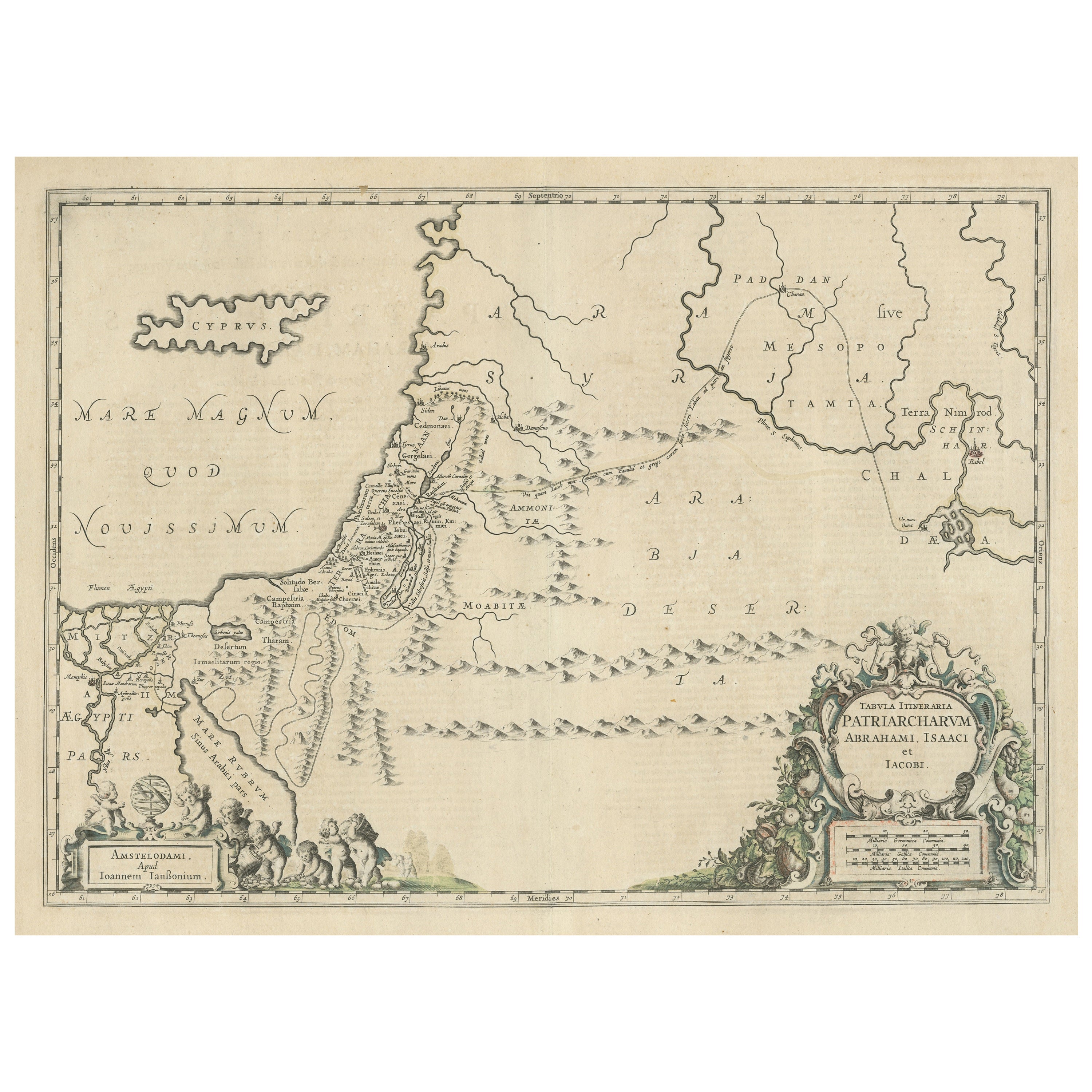
Items Similar to Antique Biblical Map of the Holy Land – Janssonius Abraham Isaac Jacob, c. 1650


Want more images or videos?
Request additional images or videos from the seller
1 of 11
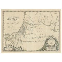
Antique Biblical Map of the Holy Land – Janssonius Abraham Isaac Jacob, c. 1650
$783.13
£584.64
€660
CA$1,088
A$1,170.30
CHF 625.44
MX$13,794.51
NOK 7,885.37
SEK 7,208.72
DKK 5,029.94
About the Item
Antique Biblical Map of the Holy Land – Janssonius Abraham Isaac Jacob, c. 1650
This finely engraved 17th-century map illustrates the biblical journeys of the Patriarchs Abraham, Isaac, and Jacob across the lands of the Old Testament. Issued by the renowned Amsterdam mapmaker Joannes Janssonius, the map presents a richly imagined vision of the Promised Land, extending from Egypt and the Mediterranean coast through Judea, Mesopotamia, and the Arabian Desert.
Designed as a tabula itineraria, the map traces sacred routes rather than political boundaries, emphasizing spiritual geography and narrative movement. Mountain ranges, deserts, rivers, and ancient cities are rendered with elegant clarity, while place names drawn from scripture reinforce its theological purpose. Cyprus appears offshore, and the Mediterranean is prominently labeled Mare Magnum, anchoring the composition in classical cartographic tradition.
Two elaborate baroque cartouches frame the lower portion of the map. One bears the full Latin title, surrounded by scrollwork and allegorical ornament, while the other includes the Amsterdam imprint of Janssonius. These decorative elements elevate the sheet from a functional map to a display piece intended for learned interiors, libraries, or devotional settings.
Maps of the Patriarchs were especially popular in the 17th century among theologians, scholars, and collectors interested in biblical history, typology, and sacred geography. Janssonius’s interpretation is among the most refined, combining scholarly content with decorative elegance typical of the Dutch Golden Age of cartography.
Today, this map appeals equally to collectors of antique maps, biblical scholars, and interior designers seeking a historically rich and visually calm work with spiritual resonance. Its balanced layout, restrained engraving, and classical ornament make it particularly suitable for traditional, neoclassical, or library interiors.
Condition:
Good antique condition. Copper engraving on laid paper with visible central fold as issued. Light age toning and minor handling wear consistent with age. Plate mark visible.
Framing tips:
Frame in dark walnut or ebonized wood with a generous ivory or light cream mat to emphasize the engraving and cartouches. Works beautifully in a classic library, study, or refined hotel-style interior.
Technique: Copper engraving
Maker: Joannes Janssonius, Amsterdam, mid-17th century
- Dimensions:Height: 20.79 in (52.8 cm)Width: 24.81 in (63 cm)Depth: 0.01 in (0.2 mm)
- Materials and Techniques:Paper,Engraved
- Place of Origin:
- Period:Mid-17th Century
- Date of Manufacture:circca 1650
- Condition:Good antique condition. Copper engraving on laid paper with visible central fold as issued. Light age toning and minor handling wear consistent with age. Plate mark visible.
- Seller Location:Langweer, NL
- Reference Number:Seller: BG-142411stDibs: LU3054348371312
About the Seller
5.0
Recognized Seller
These prestigious sellers are industry leaders and represent the highest echelon for item quality and design.
Platinum Seller
Premium sellers with a 4.7+ rating and 24-hour response times
Established in 2009
1stDibs seller since 2017
2,838 sales on 1stDibs
Typical response time: 1 hour
- ShippingRetrieving quote...Shipping from: Langweer, Netherlands
- Return Policy
More From This Seller
View AllAntique Map of the Holy Land by Keur, 1748
Located in Langweer, NL
Antique Map Holy Land titled 'De Gelegentheyd van t'Paradys ende t'Landt Canaan, Mitsgaders d'eerst bewoonde Landen der Patriarchen'. Includes five decorative vignettes, including No...
Category
Antique 18th Century Maps
Materials
Paper

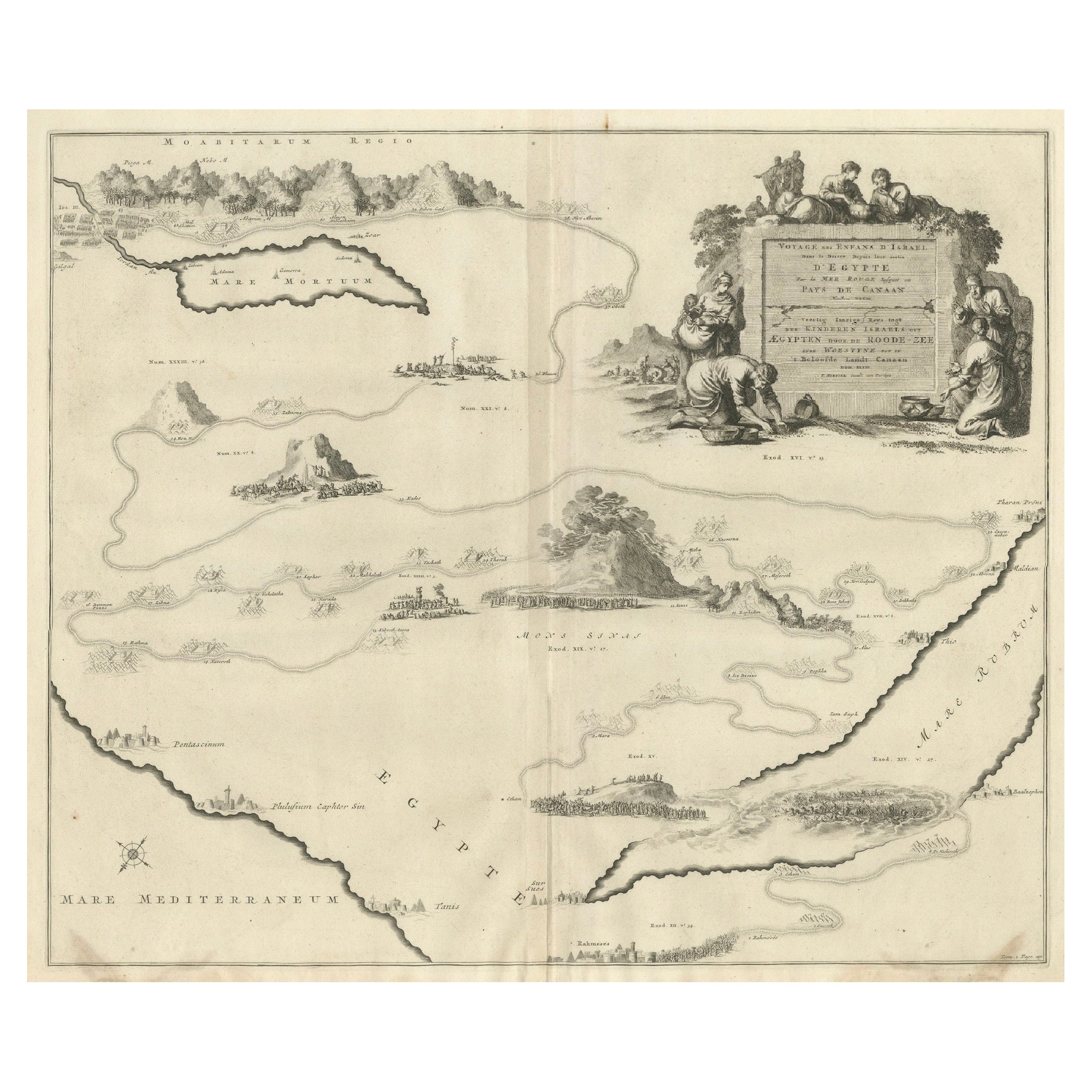
Decorative Map of the Holy Land, Wanderings of Moses by Pieter Mortier, ca. 1700
Located in Langweer, NL
Decorative Map of the Holy Land, Wanderings of Moses by Pieter Mortier, ca. 1700
Antique decorative map of the Holy Land depicting the Exodus of Moses and the Children of Israel fro...
Category
Antique Early 1700s Dutch Maps
Materials
Paper
Antique Map of the Holy Land Described in the Old and New Testament, ca.1660
Located in Langweer, NL
Antique map titled 'Geographiae Sacrae ex Veteri et Novo Testamento Desumptae Tabula Prima quae Totius Orbis Partes Continet.'
Map of the lands described in the Old and New Testame...
Category
Antique 1660s Maps
Materials
Paper

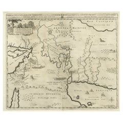
Antique Map of the Holy Land, showing the travels of Abraham, Isaac and Jacob
Located in Langweer, NL
Antique map titled 'Tabula Itineraria Patriarcharum Abrahami, Isaaci et Iacobi'. Decorative regional map of the Holy Land, showing the travels of Abraham, Isaac and Jacob. Published ...
Category
Antique Mid-17th Century Maps
Materials
Paper
Antique Map of the Holy Land by Van Luchtenburg, c.1720
Located in Langweer, NL
Antique map titled 'Heylige Land verdeeld in de Twaalf Stammen Israels (..).' Highly detailed map of the Holy Land divided into 12 tribes of Israel...
Category
Antique 18th Century Maps
Materials
Paper

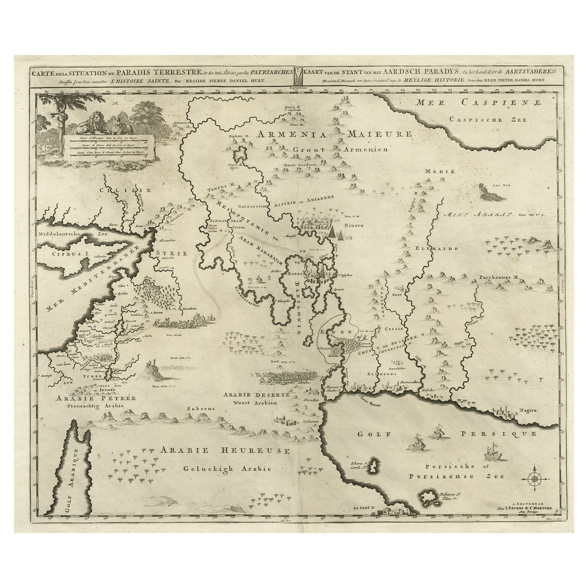
Biblical Map of the Region from the Mediterranean through the Persian Gulf, 1720
Located in Langweer, NL
Antique map titled 'Carte de la Situation du Paradis Terrestre, Et des Pais Habitez par les Patriarches Dressee pour bien entendre l'Histoire Sainte, Par Messire Pierre Daniel Huet.'
This interesting map covers the region from the Mediterranean through the Persian Gulf. Detail is omitted in favor of Biblical depictions including the Sermon on the Mount...
Category
Antique 1720s Maps
Materials
Paper
$455 Sale Price
20% Off
You May Also Like
17th Century Dutch Map of the Holy Land at the Time of Jesus by Visscher
By Nicolaus Visscher
Located in Alamo, CA
This detailed Dutch map entitled "Het Beloofe de Landt Canaan door wandelt van onsen Salichmaecker Iesu Christo, nessens syne Apostelen" by Nicolaes Visscher (1610-1679), published i...
Category
1660s Prints and Multiples
Materials
Engraving

1657 Janssonius Map of Vermandois and Cappelle, Ric. A-004
Located in Norton, MA
1657 Janssonius map of
Vermandois and Cappelle
Ric.a004
Description: Antique map of France titled 'Descriptio Veromanduorum - Gouvernement de la Cappelle'. Two detailed maps o...
Category
Antique 17th Century Unknown Maps
Materials
Paper

The Holy Land at the Time of Jesus: A 17th Century Dutch Map by Visscher
By Nicolaes Visscher II
Located in Alamo, CA
This detailed Dutch map entitled "Het Beloofe de Landt Canaan door wandelt van onsen Salichmaecker Iesu Christo, nessens syne Apostelen" by Nicolaes Visscher was published in Amsterd...
Category
Antique Mid-17th Century Dutch Maps
Materials
Paper

Antique Map - Gallia - Etching by Johannes Janssonius - 1650s
By Johannes Janssonius
Located in Roma, IT
Antique Map - Gallia is an antique map realized in 1650 by Johannes Janssonius (1588-1664).
The Map is Hand-colored etching, with coeval watercoloring.
Good conditions with slight ...
Category
1650s Modern Figurative Prints
Materials
Etching

1627 Hendrik Hondius Map Entitled "Vltoniae Orientalis Pars, " Ric.a009
Located in Norton, MA
1627 Hendrik Hondius map entitled
"Vltoniae orientalis pars,"
Ric.a009
Title:
Vltoniae orientalis : pars
Title (alt.) :
Ultoniae orientalis pars
Creator:
Mercator, Gerh...
Category
Antique 17th Century Dutch Maps
Materials
Paper

1646 Jansson Map Entitled "Procinvia Connactiae, " Ric.a006
Located in Norton, MA
1646 Jansson map entitled
"Procinvia connactiae,"
Ric.a006
Description: The PROVINCE of CONNAVGT 490 x 380From vol 4 of Jansson's Atlas Novus 1646, published in Amsterdam with...
Category
Antique 17th Century Unknown Maps
Materials
Paper
