Items Similar to Antique Caribbean Map Wall Art – Cuba Jamaica Hispaniola, Rand McNally, ca.1888


Want more images or videos?
Request additional images or videos from the seller
1 of 9
Antique Caribbean Map Wall Art – Cuba Jamaica Hispaniola, Rand McNally, ca.1888
$427.16
£318.90
€360
CA$593.45
A$638.35
CHF 341.15
MX$7,524.28
NOK 4,301.11
SEK 3,932.03
DKK 2,743.60
About the Item
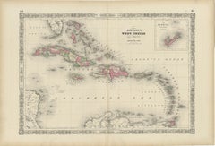
Title: Antique Caribbean Map Wall Art – Cuba Jamaica Hispaniola, Rand McNally
Description:
This finely colored antique atlas map depicts the Caribbean basin, centered on Cuba, Jamaica, Hispaniola (Haiti and the Dominican Republic), Puerto Rico, and the Lesser Antilles. The composition balances dense geographic information with a calm, decorative aesthetic, making it especially attractive as wall art.
Published by Rand, McNally
Co. in the late 19th century, the map combines precise cartography with elegant pastel color washes to distinguish islands and colonial boundaries. Delicate bathymetric lines fill the surrounding seas, adding texture and movement while enhancing the visual rhythm of the composition.
The horizontal format reads beautifully in an interior setting, with the island chain stretching naturally across the sheet. Soft greens, yellows, pinks, and muted grays create a refined palette that works equally well in classic and contemporary spaces. While historically informative, the map functions first and foremost as a decorative object.
Printed on original atlas paper, the sheet retains the authentic surface and tone of a genuine antique map. Once framed, it becomes an inviting focal point for a study, library, coastal home, or travel-inspired interior.
Condition report: Light age toning consistent with age. Minor edge wear and small handling marks from original atlas binding. Overall clean and well preserved.
Framing tips: Particularly effective in a light oak, walnut, or white-painted frame with an ivory mat. Museum glass recommended.
Technique: Color lithograph
Maker: Rand, McNally
Co., United States, late 19th century
Keywords:
antique caribbean map, cuba map wall art, jamaica antique map, west indies map, caribbean islands print, rand mcnally map, antique atlas map, tropical wall art, vintage geography print, coastal decor, travel wall art
- Dimensions:Height: 10.44 in (26.5 cm)Width: 14.18 in (36 cm)Depth: 0.01 in (0.2 mm)
- Materials and Techniques:Paper,Engraved
- Place of Origin:
- Period:
- Date of Manufacture:1888
- Condition:Light age toning consistent with age. Minor edge wear and small handling marks from original atlas binding. Overall clean and well preserved.
- Seller Location:Langweer, NL
- Reference Number:Seller: BG-12794-741stDibs: LU3054348221512
About the Seller
5.0
Recognized Seller
These prestigious sellers are industry leaders and represent the highest echelon for item quality and design.
Platinum Seller
Premium sellers with a 4.7+ rating and 24-hour response times
Established in 2009
1stDibs seller since 2017
2,836 sales on 1stDibs
Typical response time: 1 hour
- ShippingRetrieving quote...Shipping from: Langweer, Netherlands
- Return Policy
More From This Seller
View AllAntique Map of the Caribbean
Central America – West Indies, 1857
Located in Langweer, NL
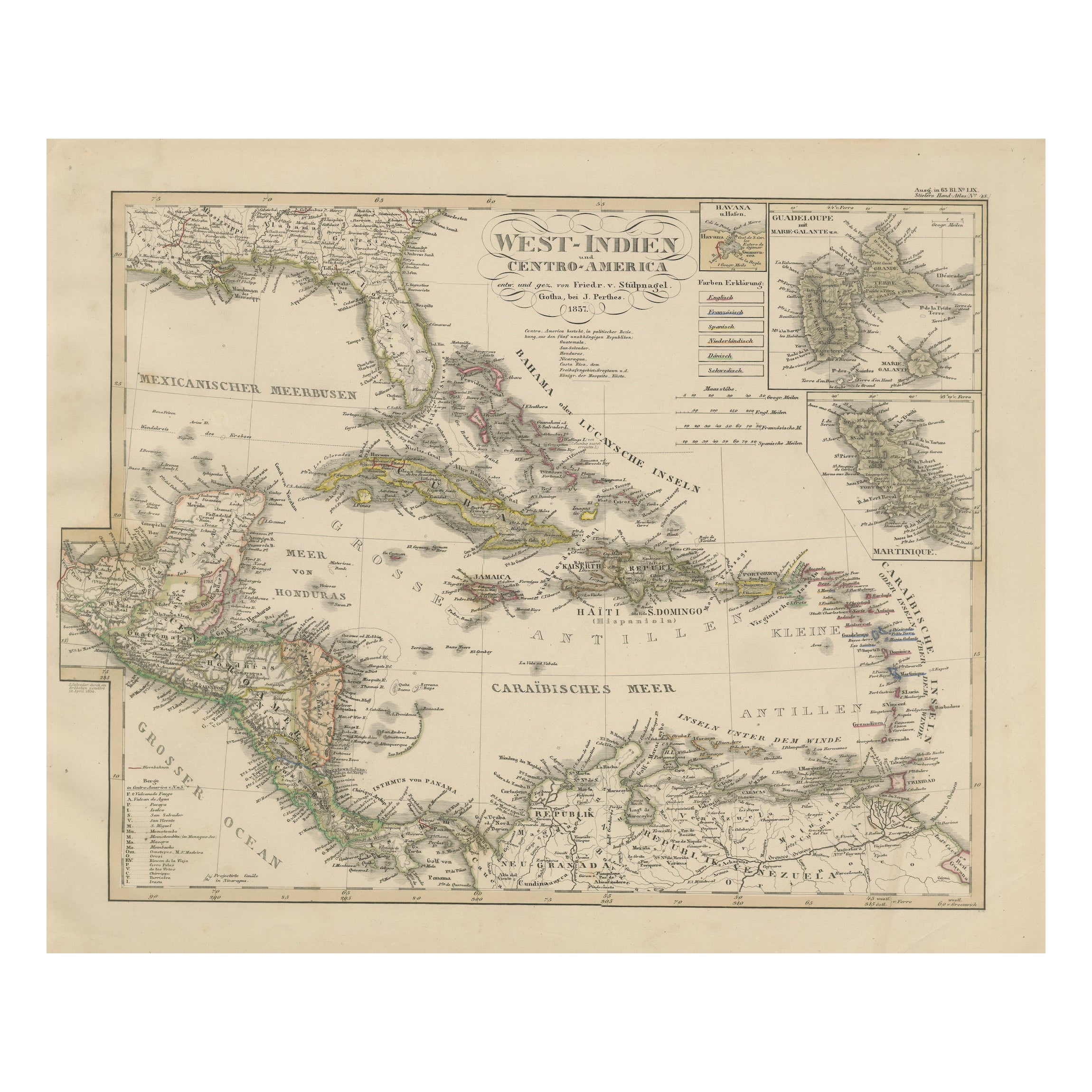
Antique Map of the Caribbean & Central America – West Indies, 1857
This finely engraved and hand-colored map titled "West-Indien und Centro-America" was published in 1857 by Justus ...
Category
Antique Mid-19th Century German Maps
Materials
Paper
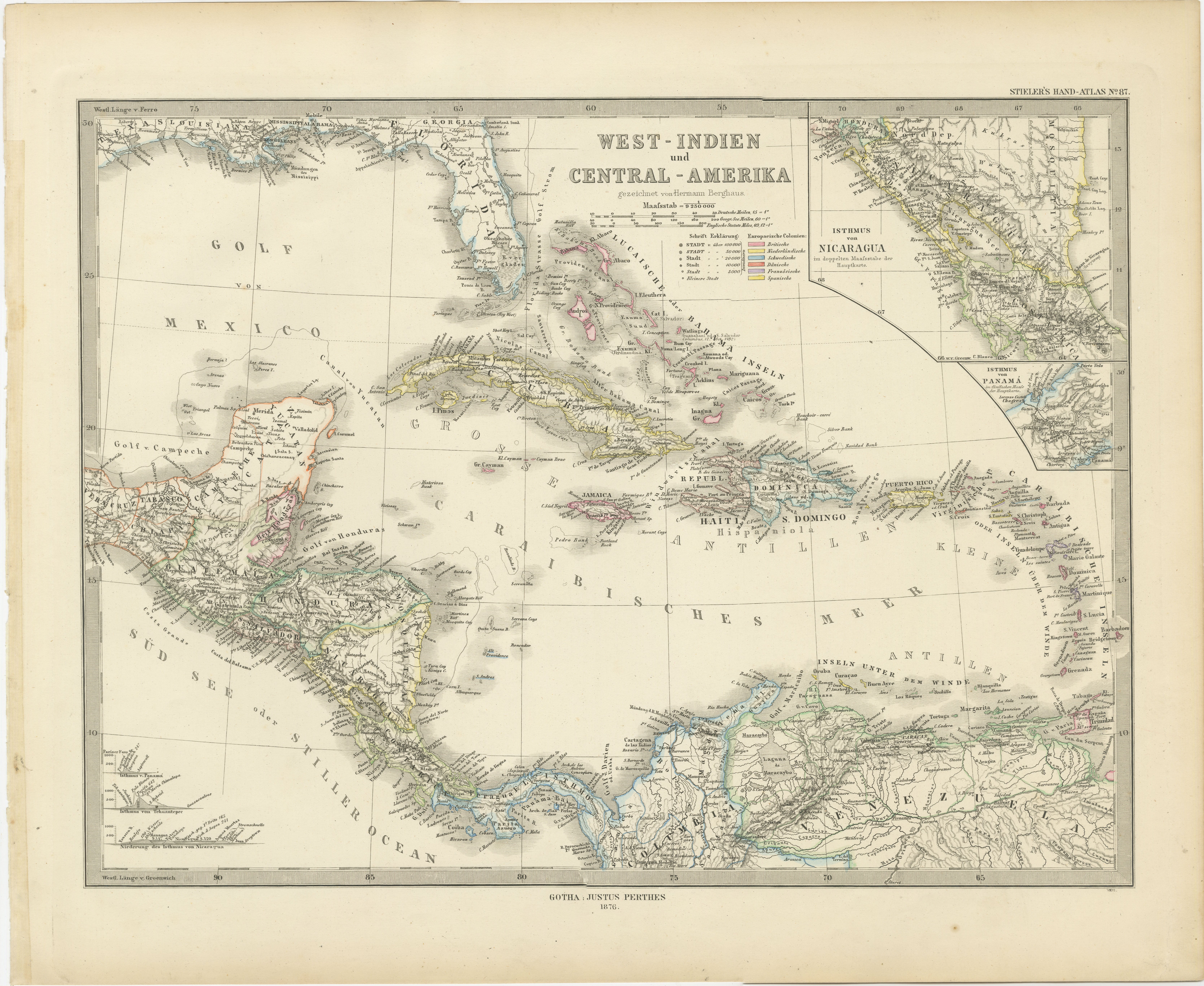
1880 Map of the Caribbean and Central America by Adolf Stieler
Located in Langweer, NL
This is a detailed map titled "West-Indien und Central-Amerika," created by Adolf Stieler and published in Gotha in 1880. The map covers the Caribbean islands and the Central America...
Category
Antique 1880s Maps
Materials
Paper
$275 Sale Price
20% Off
Antique Map of the Antilles in the Caribbean,
1875
Located in Langweer, NL
Antique map titled 'Carte des Iles Antilles'. Large map of the Antilles. This map originates from 'Atlas de Géographie Moderne Physique et Politique' by A. Levasseur. Published, 1875.
Category
Antique Late 19th Century French Maps
Materials
Paper

$326 Sale Price
44% Off
1864 Johnson
s Map of the West Indies and Bermuda
Located in Langweer, NL
Title: 1864 Johnson's Map of the West Indies and Bermuda
Description: This is an 1864 map titled "Johnson's West Indies," published by Johnson and Ward. The map provides a detailed ...
Category
Antique 1860s Maps
Materials
Paper
$303 Sale Price
20% Off
Antique Map of the Antilles and Central America – 1872
Located in Langweer, NL
Title: Antique Map of the Antilles and Central America – 1872
Description:
This finely detailed antique map, titled Antilles et Amérique Centrale, was published in 1872 under t...
Category
Antique 1870s Maps
Materials
Paper

Antique Map of Central America and the West Indies, 1882
Located in Langweer, NL
Antique map titled 'West India Islands and Central America'. Old map of Central America and the West Indies. This map originates from 'The Royal Atlas of Modern Geography, Exhibiting...
Category
Antique 19th Century Maps
Materials
Paper

You May Also Like
Original Antique Map of Central America / Florida, Arrowsmith, 1820
Located in St Annes, Lancashire
Great map of Central America.
Drawn under the direction of Arrowsmith.
Copper-plate engraving.
Published by Longman, Hurst, Rees, Orme and Brown, 1820
Unframed.
Category
Antique 1820s English Maps
Materials
Paper

Large Original Antique Map of The West Indies by Sidney Hall, 1847
Located in St Annes, Lancashire
Great map of The West Indies
Drawn and engraved by Sidney Hall
Steel engraving
Original colour outline
Published by A & C Black. 1847
Unframed
Free shipping.
Category
Antique 1840s Scottish Maps
Materials
Paper

Central America. Century Atlas antique vintage map
Located in Melbourne, Victoria
'The Century Atlas. Central America.'
Original antique map, 1903.
Inset maps of 'The Country around Lake Nicaragua'.
Central fold as issued. Map name and number printed on the reve...
Category
Early 20th Century Victorian More Prints
Materials
Lithograph

Map Of The Island Of Cuba - Guillaume Thomas Raynal (1711-1796)
Located in Porto, PT
This historical map of the Island of Cuba was produced in the late 18th century and is taken from an edition of “Atlas de toutes les parties connues du globe terrestre” by the French...
Category
Antique 18th Century Prints
Materials
Glass, Paper

Antique Jamaica Map, English, Caribbean, Cartography, Thomas Jefferys, Georgian
Located in Hele, Devon, GB
This is an antique Jamaica map. An English, framed Caribbean island engraving by Thomas Jefferys, dating to the 18th century and later, dated 1794.
Excellent Georgian period cartog...
Category
Antique 1790s British Georgian Maps
Materials
Glass, Paper

Early 19th Century Hand Colored Map of the United States and Caribbean Islands
Located in Hamilton, Ontario
Hand coloured early 19th century map by Giraldon of France titled "Etats Unis et Grandes Antilles" (United States and Greater Antilles).
Category
Antique Early 19th Century French Maps
Materials
Paper

$595 Sale Price
40% Off