Items Similar to Antique Colonial Map of Celebes Sulawesi
Lesser Sunda Islands, 1884

Want more images or videos?
Request additional images or videos from the seller
1 of 13
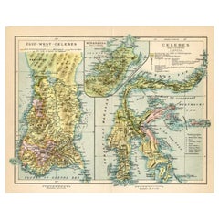
Antique Colonial Map of Celebes Sulawesi
Lesser Sunda Islands, 1884
$347.37
£259.76
€290
CA$478.59
A$521.97
CHF 276.51
MX$6,257.71
NOK 3,521.46
SEK 3,220.11
DKK 2,209.92
About the Item
Antique Colonial Map of Celebes Sulawesi
Lesser Sunda Islands 19th C
This beautiful and highly detailed antique map depicts the island of Celebes (modern-day Sulawesi) together with the Lesser Sunda Islands, including Flores, Timor, Lombok, Sumbawa, and surrounding regions of the Dutch East Indies. The map was published in Amsterdam by Seyffardt’s Boekhandel and reflects the height of Dutch colonial cartographic knowledge of Indonesia in the 19th century.
Rendered with fine precision and elegant original hand coloring, the map clearly distinguishes colonial administrative regions through a delicate color-coding system. Coastlines, mountain ranges, rivers, settlements, and maritime routes are carefully engraved, offering both geographic accuracy and strong decorative appeal. Insets provide additional regional detail, underscoring the importance of maritime navigation and territorial administration during the Dutch colonial period.
At the time of publication, Celebes and the surrounding island chains formed a critical part of the Dutch trading empire, serving as strategic hubs for spices, textiles, and maritime commerce. This map reflects not only geographic knowledge but also the political structure of colonial governance within the East Indies. The naming conventions, district boundaries, and shipping zones illustrate the deep entanglement between cartography and empire.
Visually, the map is exceptionally attractive. The rich yet restrained hand coloring, crisp engraving lines, balanced layout, and large format make it suitable for both historical collections and sophisticated interior display. It works equally well as a statement wall piece in a study, library, gallery, or modern living space where historical cartography adds intellectual depth and visual warmth.
Maps of this region are increasingly sought after due to the growing interest in Southeast Asian history, colonial expansion, and maritime exploration. This example offers an excellent balance between decorative presence and documentary value, making it desirable for collectors of Asian cartography, Dutch colonial material, and antique maps in general.
Condition report: Good antique condition. General toning consistent with age. Scattered foxing visible across the sheet. Clear plate impression. Margins intact. No major tears or losses observed.
Framing tips: This map frames beautifully with a soft off-white or light taupe mat and a medium-dark walnut, ebonized, or antique gilt frame. Museum glass is recommended to protect the original hand coloring and enhance contrast without glare.
Technique: Hand-colored lithograph
Maker: Seyffardt’s Boekhandel, Amsterdam, 19th century
- Dimensions:Height: 19.1 in (48.5 cm)Width: 15.36 in (39 cm)Depth: 0.01 in (0.2 mm)
- Materials and Techniques:
- Place of Origin:
- Period:
- Date of Manufacture:1884
- Condition:Condition report: Good antique condition. General toning consistent with age. Scattered foxing visible across the sheet. Clear plate impression. Margins intact. No major tears or losses observed.
- Seller Location:Langweer, NL
- Reference Number:Seller: BG-14172-81stDibs: LU3054347872712
About the Seller
5.0
Recognized Seller
These prestigious sellers are industry leaders and represent the highest echelon for item quality and design.
Platinum Seller
Premium sellers with a 4.7+ rating and 24-hour response times
Established in 2009
1stDibs seller since 2017
2,788 sales on 1stDibs
Typical response time: <1 hour
- ShippingRetrieving quote...Shipping from: Langweer, Netherlands
- Return Policy
More From This Seller
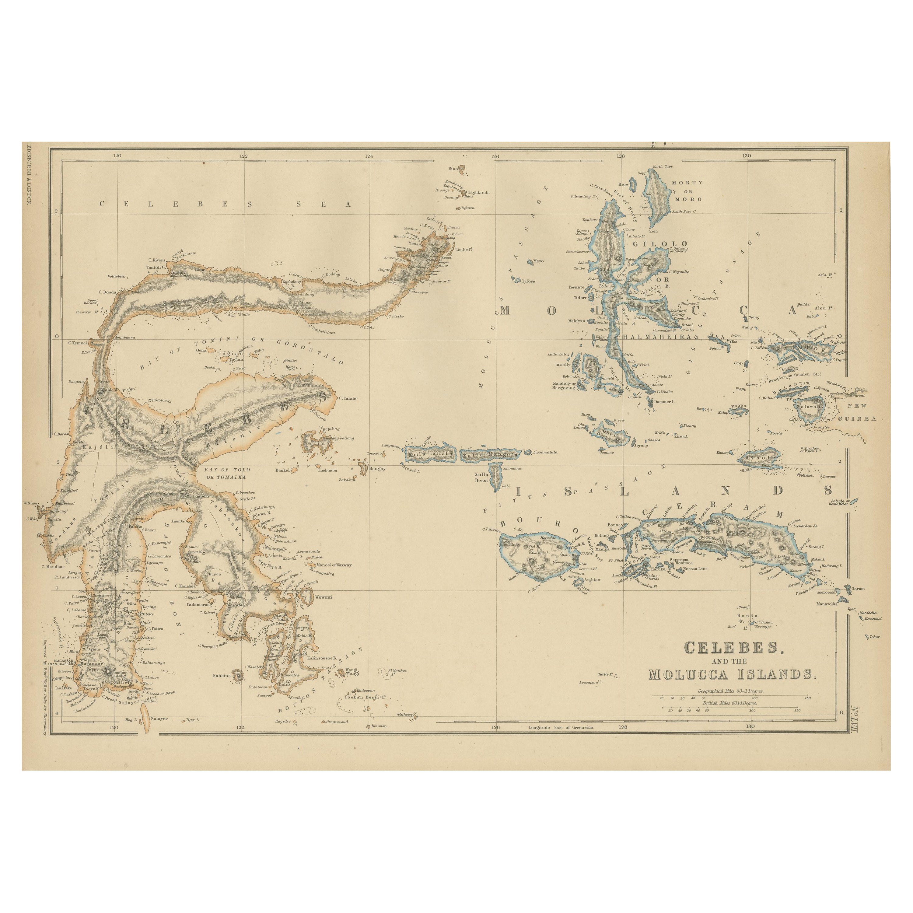
View AllAntique Map of Celebes and the Maluku Islands by W. G. Blackie, 1859
Located in Langweer, NL
Antique map titled 'Celebes and The Molucca Islands '. Original antique map of Celebes and the Maluku Islands (Moluccas). This map originates from ‘The Imperial Atlas of Modern Geogr...
Category
Antique Mid-19th Century Maps
Materials
Paper
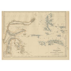
$191 Sale Price
20% Off
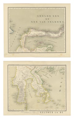
Antique Two-Sheet Map of Celebes Sulawesi - Dornseiffen, Dutch East Indies, 1884
Located in Langweer, NL
Antique Two-Sheet Map of Celebes Sulawesi by Dornseiffen, Published in 1884 - Dutch East Indies
This striking two-sheet antique map set depicts the island of Celebes (modern Sulawes...
Category
Antique 1880s Dutch Maps
Materials
Paper
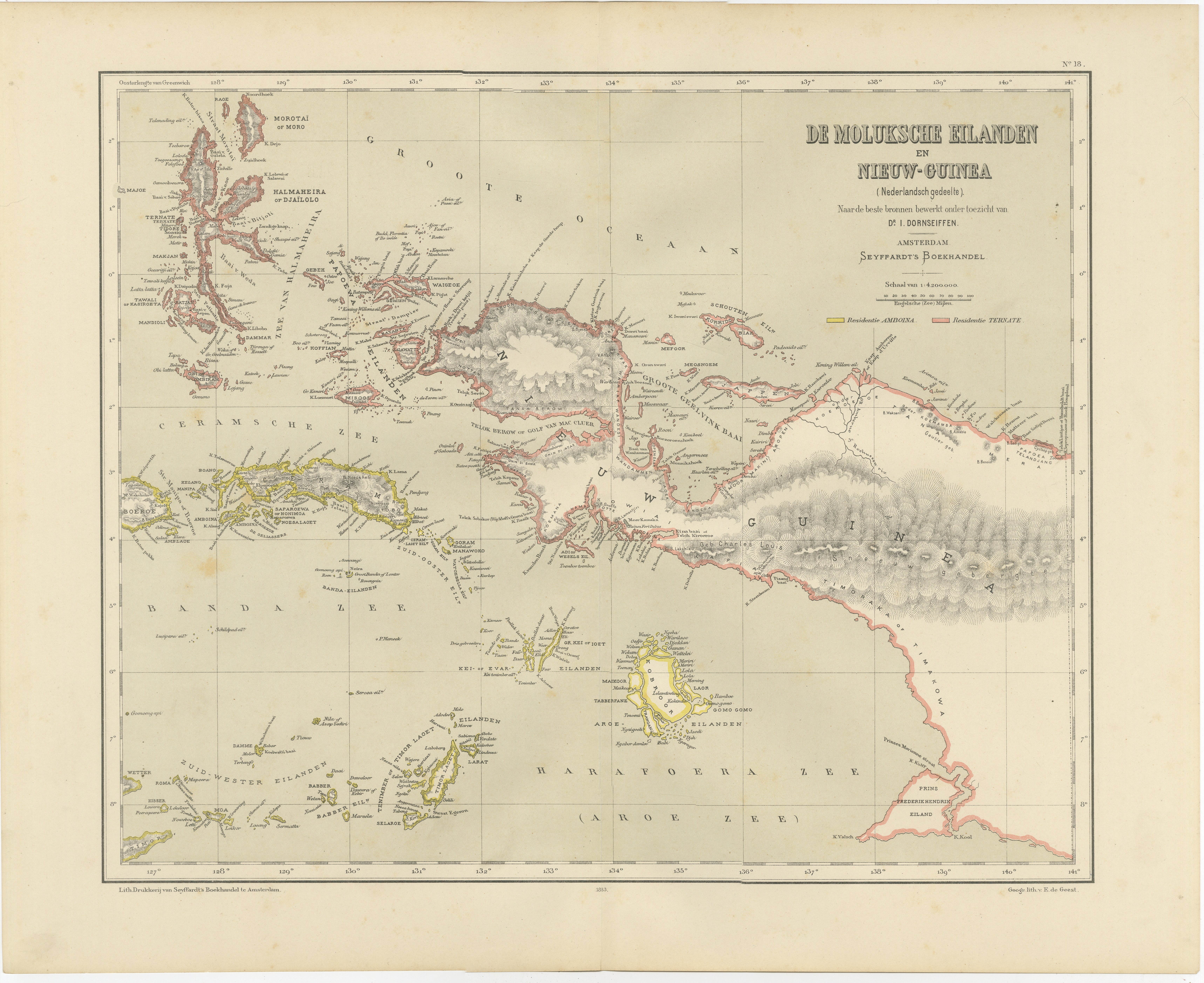
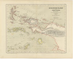
Antique Colonial Dutch Map of the Moluccas
New Guinea by Dornseiffen, 1884
Located in Langweer, NL
Antique Dutch Map of the Moluccas & New Guinea by Dornseiffen 1884 Indonesia
This decorative antique map depicts the Moluccan Islands (Spice Islands) and the western portion of New ...
Category
Antique 1880s Dutch Maps
Materials
Paper
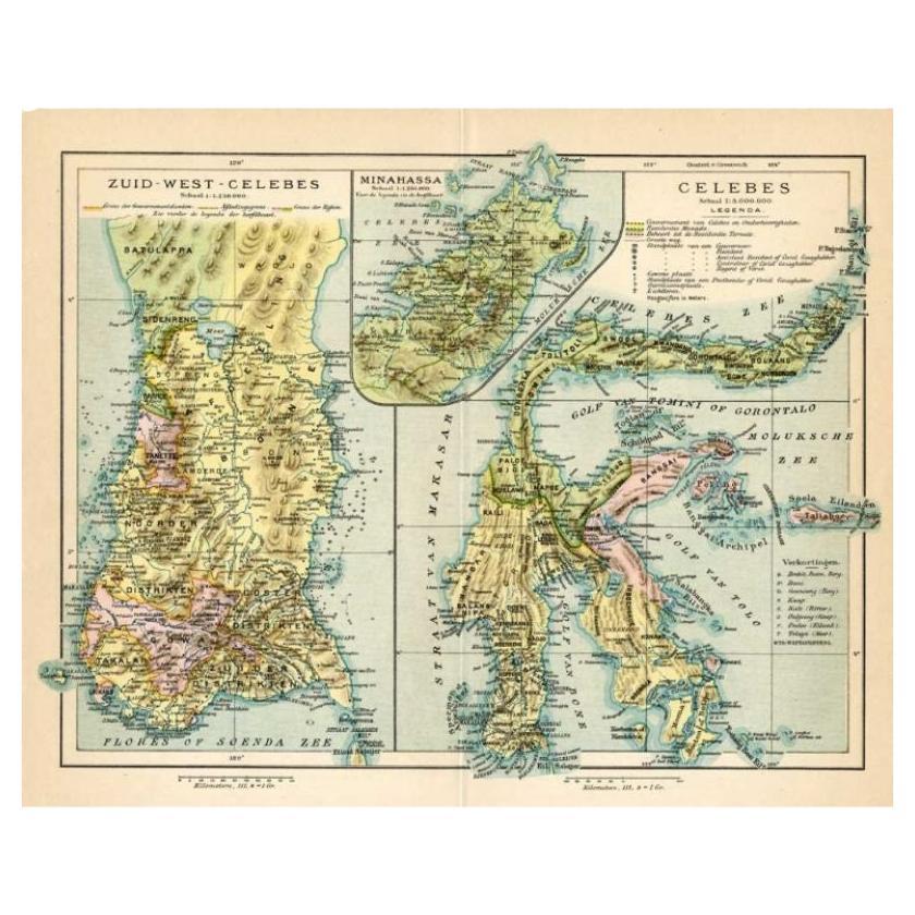
Antique Map of Sulawesi by Winkler Prins, c.1900
Located in Langweer, NL
Antique map titled 'Celebes.' (Sulawesi .) This map shows the Indonesian island of Sulawesi, one of the Sunda islands. With inset maps of South-west Sulawesi and Semenanjung Minahassa. Legend and scale. This map originates from 'De Grote Winkler Prins...
Category
20th Century Maps
Materials
Paper
$69 Sale Price
20% Off
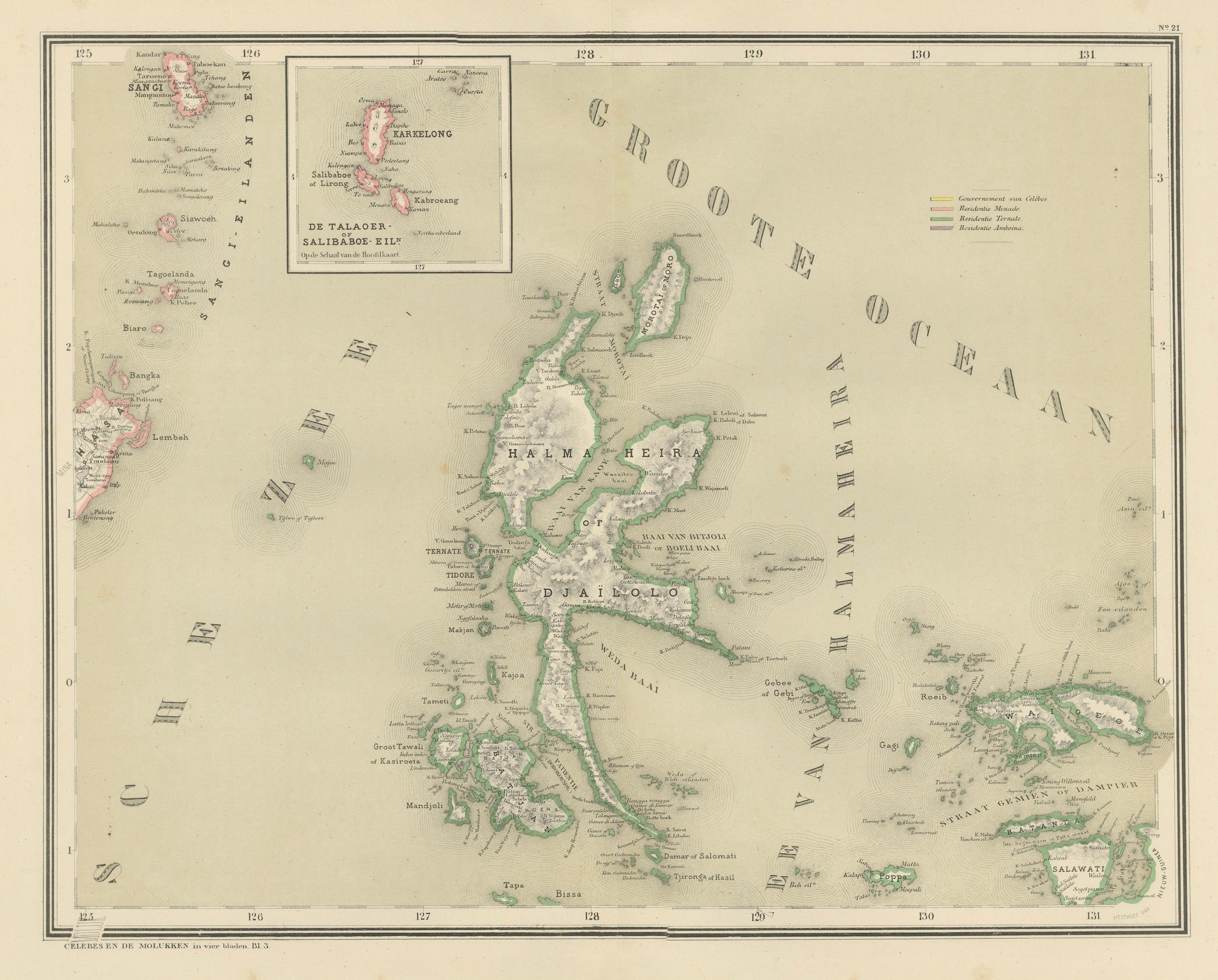
Antique Map of Halmahera, Ternate, Tidore, Moluccas by Dornseiffen - 1884
Located in Langweer, NL
Antique Map of Halmahera Ternate Tidore Moluccas Dornseiffen 1884
This finely detailed antique map depicts the northern Moluccan Islands with Halmahera (Gilolo) at its center, inclu...
Category
Antique 1880s Dutch Maps
Materials
Paper
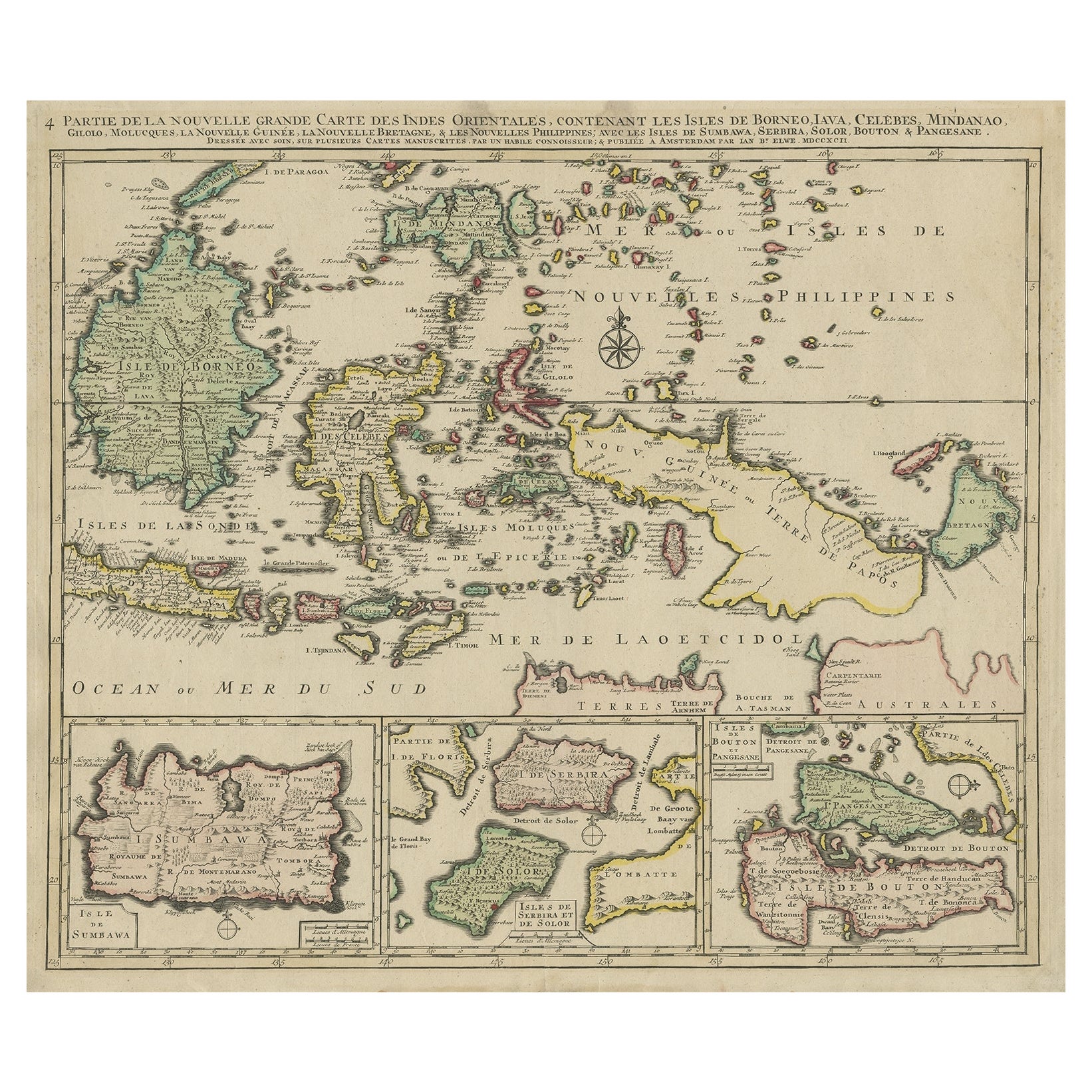
Old Map of the East Indonesian Islands Borneo, Celebes, New Guinea, Bali, 1792
Located in Langweer, NL
Antique map titled 'Partie de la Nouvelle Grande Carte des Indes Orientales, contenant les Isles de Borneo, Iava, Celebes, Mindanao (..)'.
Detailed map of the Indonesian islands ...
Category
Antique 1790s Maps
Materials
Paper

You May Also Like
Original Antique Map of South East Asia by Thomas Clerk, 1817
Located in St Annes, Lancashire
Great map of South East Asia
Copper-plate engraving
Drawn and engraved by Thomas Clerk, Edinburgh.
Published by Mackenzie And Dent, 1817
Unframed.
Category
Antique 1810s English Maps
Materials
Paper

Large Original Antique Map of Java and Borneo, Fullarton, C.1870
Located in St Annes, Lancashire
Great map of Java and Borneo
Wonderful figurative borders
From the celebrated Royal Illustrated Atlas
Lithograph. Original color.
Published by Fullarton, Edinburgh. C.1870
Unfr...
Category
Antique 1870s Scottish Maps
Materials
Paper

Original Antique Map of The Philippines. C.1900
Located in St Annes, Lancashire
Fabulous map of The Philippines
Original color.
Engraved and printed by the George F. Cram Company, Indianapolis.
Published, C.1900.
Unframed.
Free shipping.
Category
Antique 1890s American Maps
Materials
Paper

Large Original Vintage Map of The Pacific Islands Including Hawaii
Located in St Annes, Lancashire
Great map of The Pacific Islands
Unframed
Original color
By John Bartholomew and Co. Edinburgh Geographical Institute
Published, circa 1...
Category
Vintage 1920s British Maps
Materials
Paper

Antique 1803 Italian Map of Asia Including China Indoneseia India
Located in Amsterdam, Noord Holland
Antique 1803 Italian Map of Asia Including China Indoneseia India
Very nice map of Asia. 1803.
Additional information:
Type: Map
Country of Manufacturing: Europe
Period: 19th centu...
Category
Antique 19th Century European Maps
Materials
Paper

$438 Sale Price
39% Off
Map of the East Indies: An Original 18th Century Hand-colored Map by E. Bowen
Located in Alamo, CA
This is an original 18th century hand-colored map entitled "An Accurate Map of the East Indies Exhibiting the Course of the European Trade both on the Continent and Islands" by Emanu...
Category
Mid-18th Century Old Masters Landscape Prints
Materials
Engraving
