Items Similar to Antique Colored Belgium Map Flandria Gallica Flanders Henricus Hondius

Want more images or videos?
Request additional images or videos from the seller
1 of 13
Antique Colored Belgium Map Flandria Gallica Flanders Henricus Hondius
$245
$35030% Off
£186.56
£266.5230% Off
€214.82
€306.8930% Off
CA$347.19
CA$495.9830% Off
A$373.45
A$533.5030% Off
CHF 199.58
CHF 285.1230% Off
MX$4,401.90
MX$6,288.4330% Off
NOK 2,516.26
NOK 3,594.6630% Off
SEK 2,300.34
SEK 3,286.2030% Off
DKK 1,605.08
DKK 2,292.9730% Off
About the Item
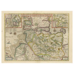
Antique hand colored map of Flanders, Belgium, engraved by Henricus Hondius.
Sans frame - 21.25” x 18”.
- Dimensions:Height: 20 in (50.8 cm)Width: 0.625 in (1.59 cm)Depth: 23.375 in (59.38 cm)
- Style:Renaissance (Of the Period)
- Materials and Techniques:
- Period:
- Date of Manufacture:19th century
- Condition:Wear consistent with age and use. Crease down center; some holes/discoloration; dark stain.
- Seller Location:Dayton, OH
- Reference Number:Seller: 291691stDibs: LU5343223385772

About the Seller
5.0
Platinum Seller
Premium sellers with a 4.7+ rating and 24-hour response times
Established in 2010
1stDibs seller since 2020
1,769 sales on 1stDibs
Typical response time: <1 hour
- ShippingRetrieving quote...Shipping from: Dayton, OH
- Return Policy
More From This Seller
View All18th Century Antique Conrad Lotter Septentrionalis Meridionalis American Maps
Located in Dayton, OH
Pair of rare hand colored maps from the 1770's, depicting "America Septentrionalis" (North America), engraved by Georg Friedrich Lotter and America Meridionalis (South America), engr...
Category
Antique 18th Century Maps
Materials
Paper
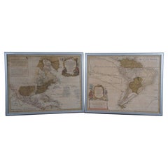
$2,100 Sale Price
30% Off
Antique 1844 J Calvin Smith JH Colton Midwest United States Survey Map 27"
By J.H. Colton
Located in Dayton, OH
Antique framed black and white map of seven Midwestern American states. Guide Through Ohio, Michigan, Indiana, Illinois, Missouri, Wisco...
Category
Antique 1840s Maps
Materials
Paper

$822 Sale Price
30% Off
Vincenzo Coronelli
s Colored Map of the New World Western Hemisphere Framed 47"
By Vincenzo Coronelli
Located in Dayton, OH
A Framed Reproduction of Coronelli's Map of the New World, Attributed to Trevor James Company. The map shows the Western Hemisphere including the discoveries made by Abel Tasman in A...
Category
20th Century Maps
Materials
Paper

$945 Sale Price
30% Off
Vintage Oversized New York City Lower Manhattan 1840s Map Print
Located in Dayton, OH
Vintage late 20th century reproduction print of New York City featuring lower Manhattan in 1840.
Category
Late 20th Century Victorian Maps
Materials
Paper

$700 Sale Price
30% Off
Antique Italian Baroque Madame la Princesse de Lamballe Lithograph Print Framed
Located in Dayton, OH
Antique lithograph portrait print of Madame la Princesse de Lambelle, an Italian Noblewoman. Black and white with hand colored details in blue. Princess Marie Louise Thérèse of Savoy...
Category
Antique Late 19th Century Victorian Prints
Materials
Giltwood, Paper
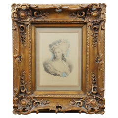
$294 Sale Price
30% Off
Antique Works of Shakespeare Imperial Edition Vol II Charles Knight Virtue 15"
Located in Dayton, OH
Late 19th century folio book: "The Works of Shakespeare" - Imperial edition - Edited by Charles Knight - With Illustrations on Steel from Pictures by assorted artists - Volume II - P...
Category
Antique Late 19th Century American Books
Materials
Leather, Paper
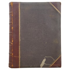
$210 Sale Price
30% Off
You May Also Like
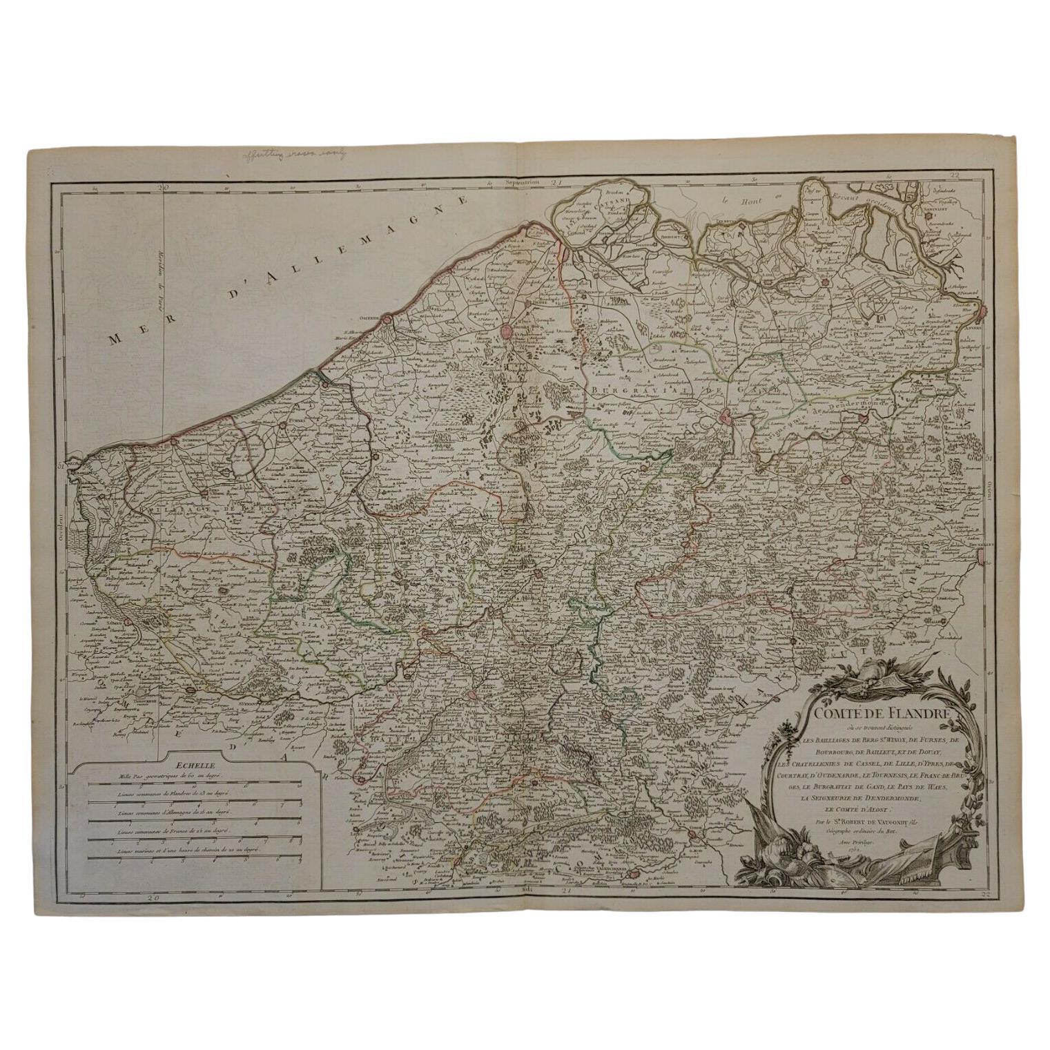
1752 Vaugoundy Map of Flanders : Belgium, France, and the Netherlands, Ric.a002
Located in Norton, MA
Large Vaugoundy Map of Flanders:
Belgium, France, and the Netherlands
Colored -1752
Ric.a002
Description: This is a 1752 Didier Robert de Vaugondy map of Flanders. The map de...
Category
Antique 17th Century Unknown Maps
Materials
Paper

1571-1638 Willem Blaeu map entitled, "Ilcadorino, " Hand Colored Ric0009
Located in Norton, MA
Willem Blaeu map entitled,
"Ilcadorino,".
Hand colored.
Description: large, unusual, and nice antique copper engraved map of Ilcadorino, by Willem BL...
Category
Antique 16th Century Dutch Maps
Materials
Paper

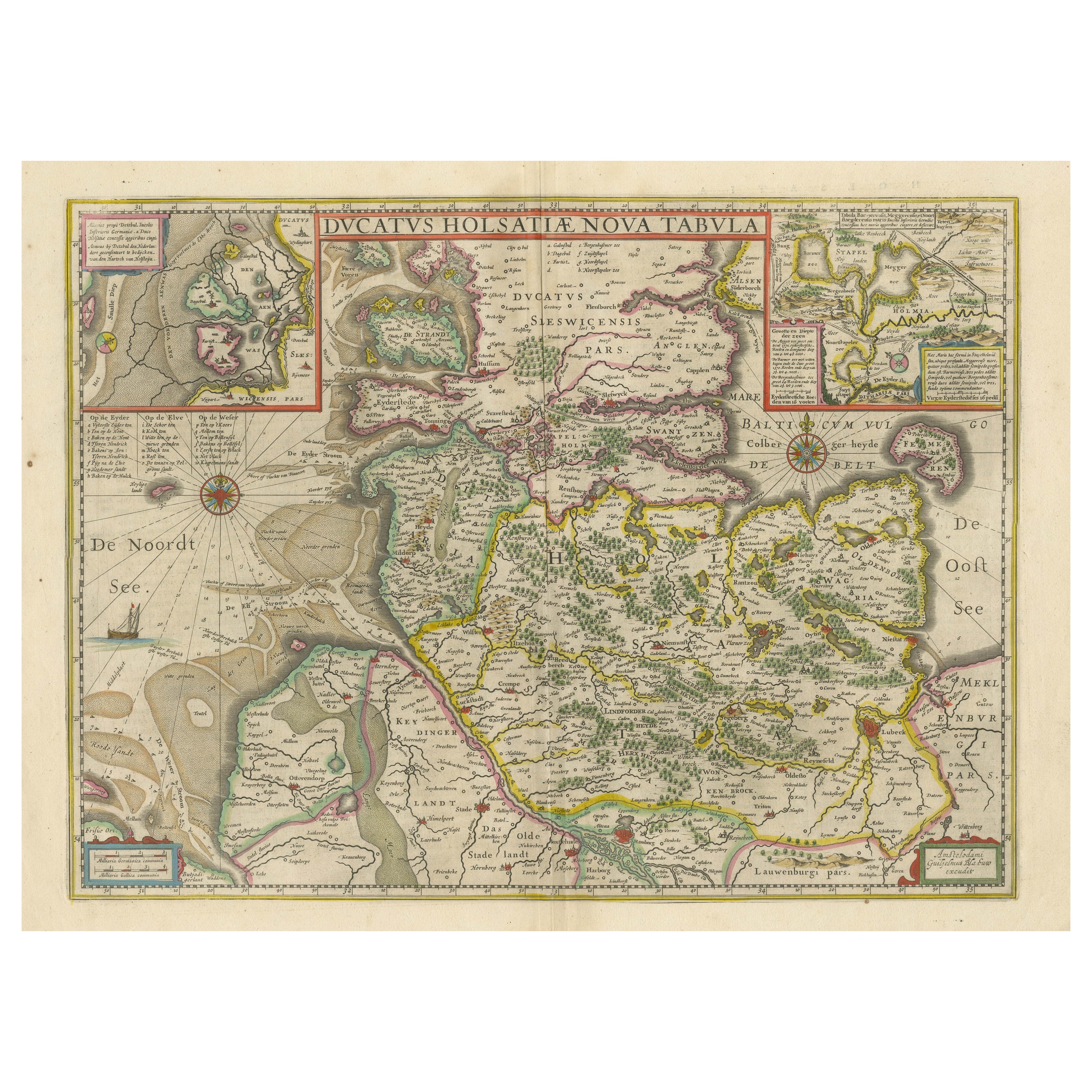
Original Antique Map of the Duchy of Holstein
By Willem Blaeu
Located in Langweer, NL
Antique map titled 'Ducatus Holsatiae Nova Tabula'. Original old map of the Duchy of Holstein, the northernmost territory of the Holy Roman Empire, from the mid-17th Century. To the ...
Category
Antique Mid-17th Century Maps
Materials
Paper
$1,044 Sale Price
20% Off
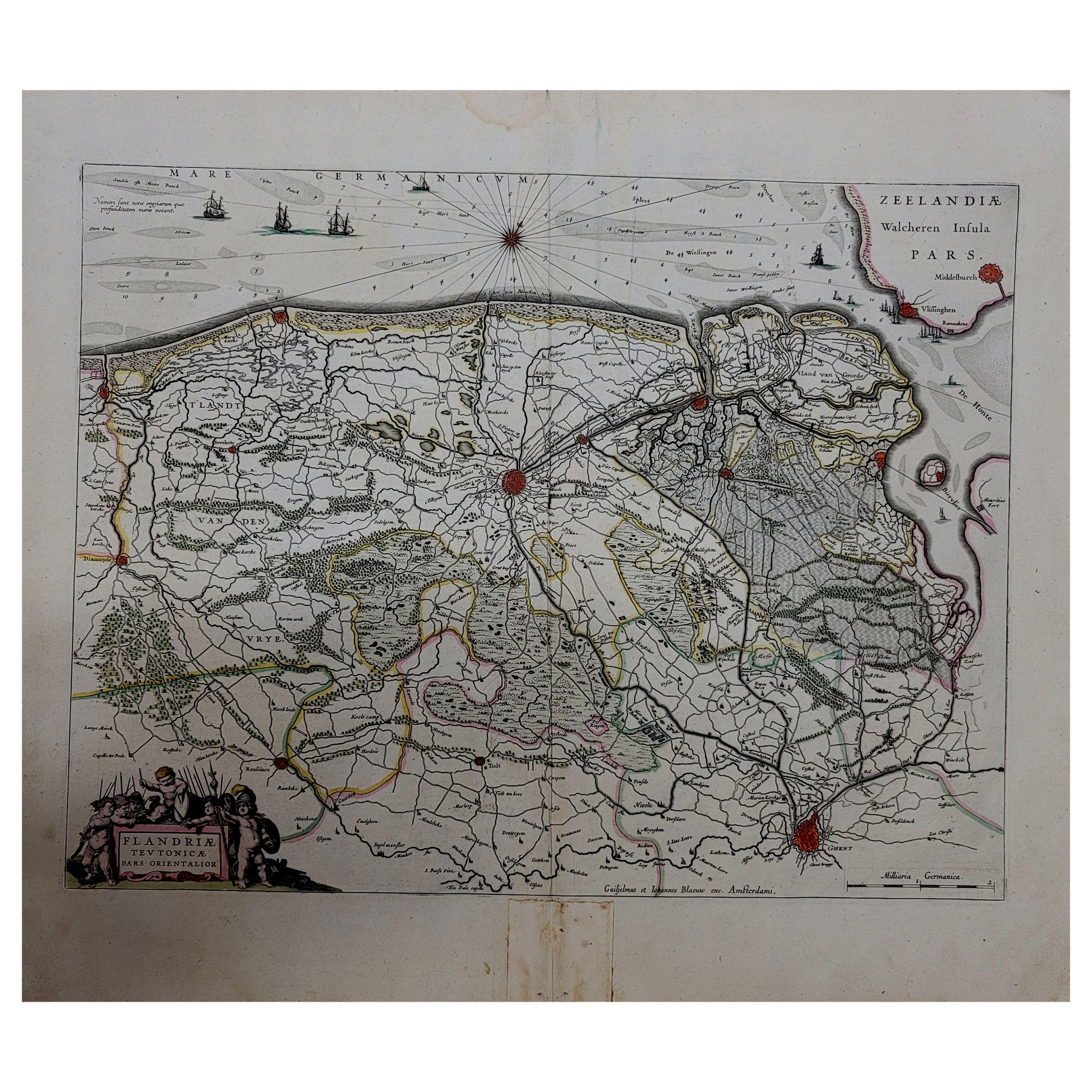
1643 Willem&Joan Blaeu Map NW Flanders "Flandriae Teutonicae Pars Prientalior
Located in Norton, MA
1643 Willem and Joan Blaeu map of northwest Flanders, entitled
"Flandriae Teutonicae Pars Prientalior,"
Ric0012
" Authentic" - Map of the northwest Fl...
Category
Antique 17th Century Dutch Maps
Materials
Paper

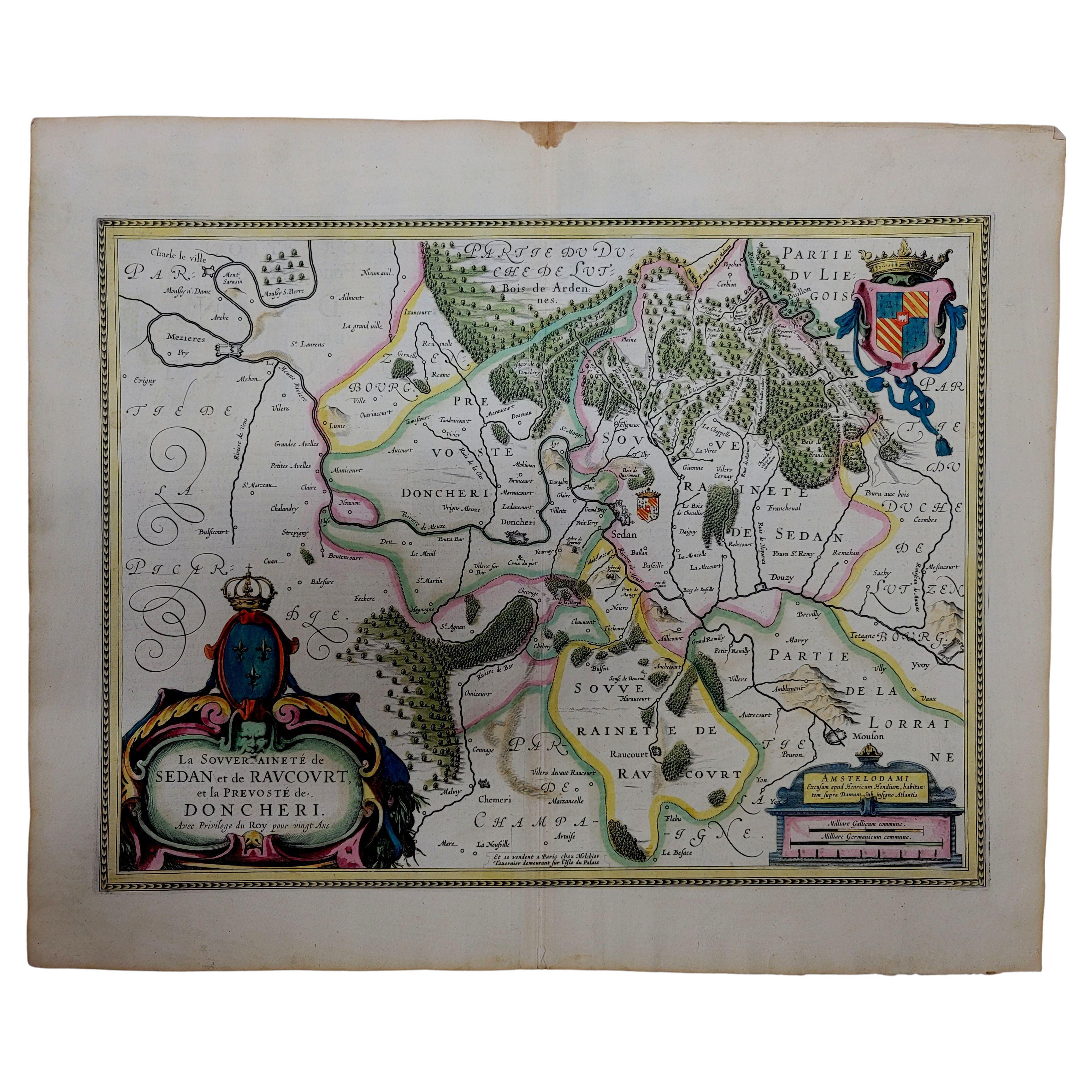
1633 Map "La Souverainete De Sedan Et De Raucourt, Et La Prevoste Ric0011
Located in Norton, MA
1653 map entitled
"La Souverainete de Sedan et de Raucourt, et la Prevoste de Doncheri,"
Ric0011
Description:
Lovely map centered on Sedan and Doncheri and the Meuze River fr...
Category
Antique 17th Century Dutch Maps
Materials
Paper

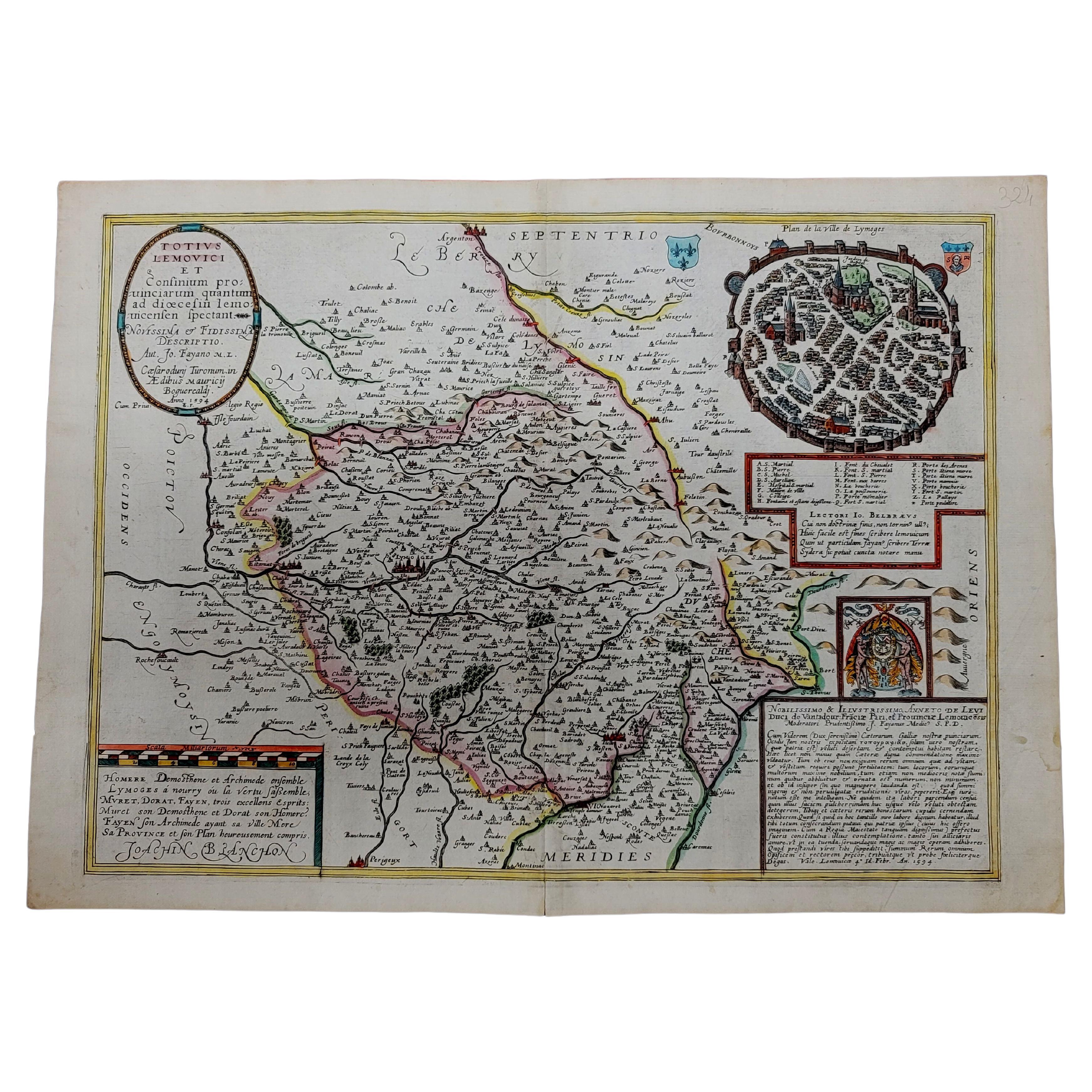
1594 Maurice Bouguereau Map of the Region Limoges, France, Ric0015
Located in Norton, MA
1594 Maurice Bouguereau map of the region Limoges, France, entitled
"Totivs Lemovici et Confinium Pro Uinciarum Quantum ad Dioecefin Lemo Uicenfen Fpectant,"
Hand Colored
Ric0015
Jean IV Le Clerc...
Category
Antique 16th Century Dutch Maps
Materials
Paper

More Ways To Browse
World Map Of Trade Routes
J Walker
Mercator Map
Antique Map Of Switzerland
Albanian Antique
Antique Pamphlets
Antique Mediterranean Map
Antique Map Mexico
Antique Map Paris
Antique Puerto Rico
West Indies Antique Furniture
Map Of Ireland
Antique Indian Maps
Antique Map Ortelius
Antique Roman Map
D Plan
Roman Map
Map Of Paris