Items Similar to Antique Dutch Map – Province of Noord-Holland from Sleeswijk Atlas, 1914
Want more images or videos?
Request additional images or videos from the seller
1 of 10
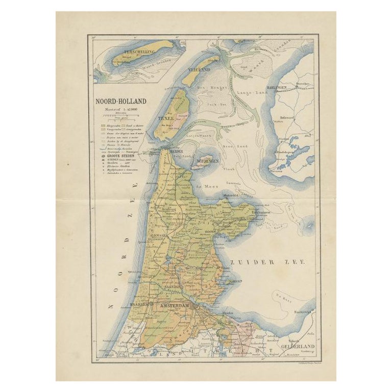
Antique Dutch Map – Province of Noord-Holland from Sleeswijk Atlas, 1914
$251.55
£188.10
€210
CA$346.57
A$377.98
CHF 200.23
MX$4,531.45
NOK 2,550.02
SEK 2,331.80
DKK 1,600.28
About the Item
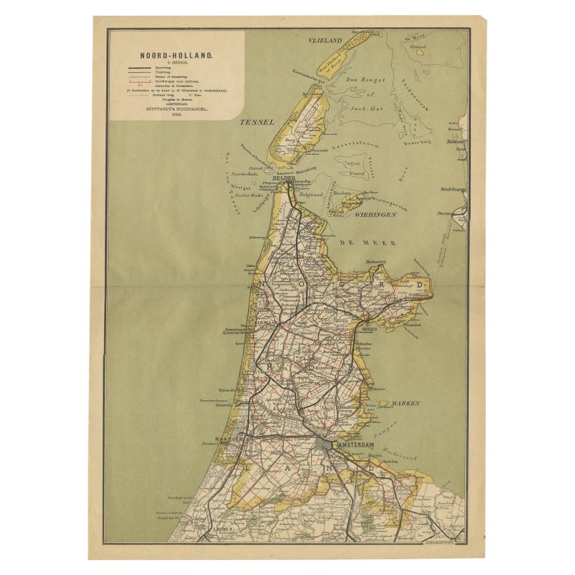
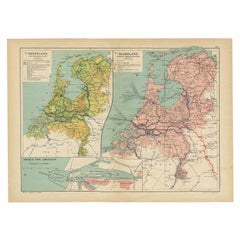
Antique Map of Noord-Holland – Sleeswijk Atlas, 1914
This finely detailed antique map of Noord-Holland was published in 1914 as part of the Sleeswijk Atlas, an important Dutch school atlas series widely used in the early 20th century. The map covers the entire province of Noord-Holland, extending from the island of Texel and the Waddenzee in the north to the vicinity of Leiden in the south. The cartography is rich with information, highlighting not only major cities such as Amsterdam, Haarlem, Alkmaar, Hoorn, and Enkhuizen, but also an intricate network of towns, villages, waterways, dikes, and reclaimed polders that define the Dutch landscape.
Insets of Terschelling and Vlieland appear in the upper left corner, showing their strategic position in the Wadden Sea. The legend (“Verklaring”) provides a clear key to roads, railways, tramlines, waterways, municipal boundaries, and polder limits, reflecting the infrastructure of the Netherlands at the dawn of the First World War. Red lines mark the expanding railway network, while waterways and canals are carefully delineated, emphasizing their central role in Dutch transport and trade.
The map is printed in soft tones with fine hand-colored outlines, typical of Sleeswijk atlas production. It reflects the balance between educational clarity and cartographic elegance, making it a fine representation of Dutch school atlases from the early 20th century. The lower margin bears the imprint of publisher A. Sleeswijk in Bussum and lithographer J. Smulders
Co. in The Hague.
This piece is not only a decorative historical map but also a document of the Netherlands’ continuous struggle and triumph over water through dike construction, land reclamation, and canal systems. Collectors of Dutch cartography and lovers of regional history will appreciate its historical depth and aesthetic appeal.
Condition report: Good condition with original centerfold as issued. Minor age toning and small handling signs along the margins. Plate mark visible. Colors remain clear and well-preserved.
Framing tips: A light cream or ivory mat will complement the soft coloring, while a thin black or dark wood frame will give the map a refined, classic presentation. For a more traditional appearance, a gilt frame adds warmth and enhances the historical character.
Technique: Lithograph with original color
Maker: A. Sleeswijk, Bussum / J. Smulders
Co., The Hague, 1914
- Dimensions:Height: 14.3 in (36.3 cm)Width: 9.38 in (23.8 cm)Depth: 0.01 in (0.2 mm)
- Materials and Techniques:
- Place of Origin:
- Period:
- Date of Manufacture:circa 1914
- Condition:Condition report: Good condition with original centerfold as issued. Minor age toning and small handling signs along the margins. Plate mark visible. Colors remain clear and well-preserved.
- Seller Location:Langweer, NL
- Reference Number:Seller: BG-07094-11stDibs: LU3054346539022
About the Seller
5.0
Recognized Seller
These prestigious sellers are industry leaders and represent the highest echelon for item quality and design.
Platinum Seller
Premium sellers with a 4.7+ rating and 24-hour response times
Established in 2009
1stDibs seller since 2017
2,791 sales on 1stDibs
Typical response time: <1 hour
- ShippingRetrieving quote...Shipping from: Langweer, Netherlands
- Return Policy
More From This Seller
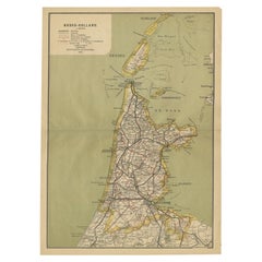
View AllAntique Map of Noord-Holland, Province of The Netherlands, 1902
Located in Langweer, NL
Antique map titled 'Noord-Holland'. Lithographed map of the province of Noord-Holland, the Netherlands. This map originates from 'Atlas van Nederland'. Artists and Engravers: Publish...
Category
20th Century Maps
Materials
Paper
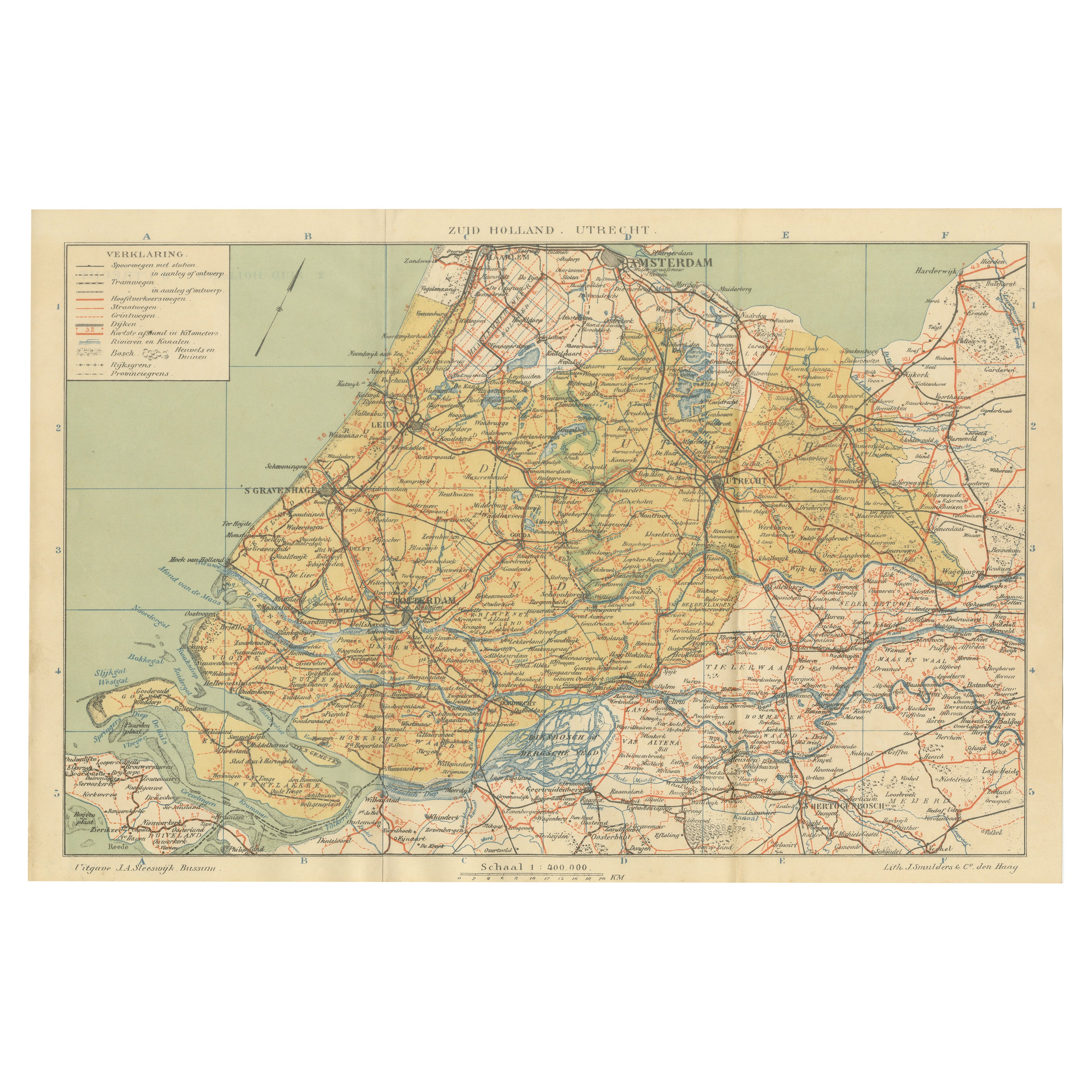
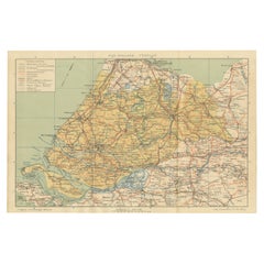
Antique Dutch Map of Zuid-Holland
Utrecht – Sleeswijk Provincial Atlas, 1914
Located in Langweer, NL
Antique Map of Zuid-Holland & Utrecht – Sleeswijk Atlas, 1914
This antique map of Zuid-Holland and Utrecht was published in 1914 in the well-known Sleeswijk Atlas, a Dutch school at...
Category
Early 20th Century Dutch Maps
Materials
Paper
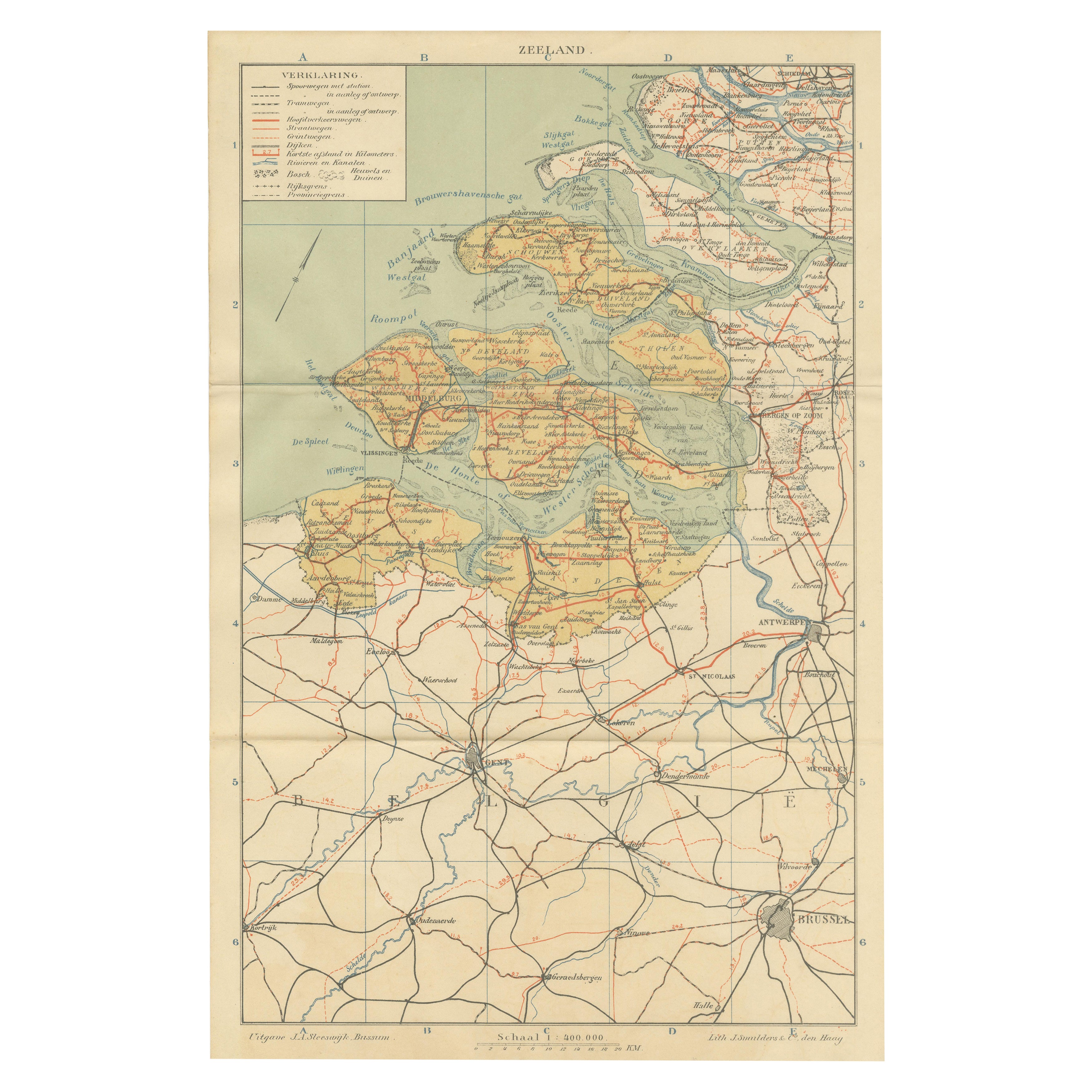
Rare Antique Map of Zeeland – Sleeswijk Atlas of the Netherlands, 1914
Located in Langweer, NL
Antique Map of Zeeland – Sleeswijk Atlas, 1914
This antique map of Zeeland was published in 1914 in the Sleeswijk Atlas, one of the most widely used Dutch school atlases of the earl...
Category
Early 20th Century Dutch Maps
Materials
Paper

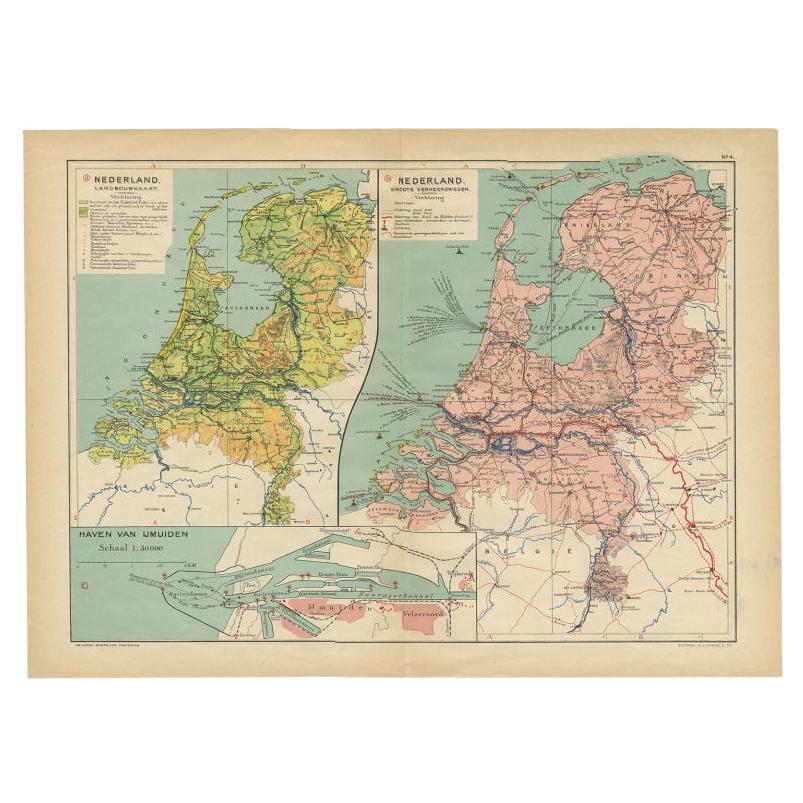
Antique Map of the Netherlands and IJmuiden by Beekman
Schuiling, 1927
Located in Langweer, NL
Two maps on one sheet titled 'Nederland Landbouwkaart' and 'Nederland Groote Verkeerswegen'. With an inset map of the harbour of IJmuiden (The Netherlands). This map originates from ...
Category
20th Century Maps
Materials
Paper
$62 Sale Price
20% Off
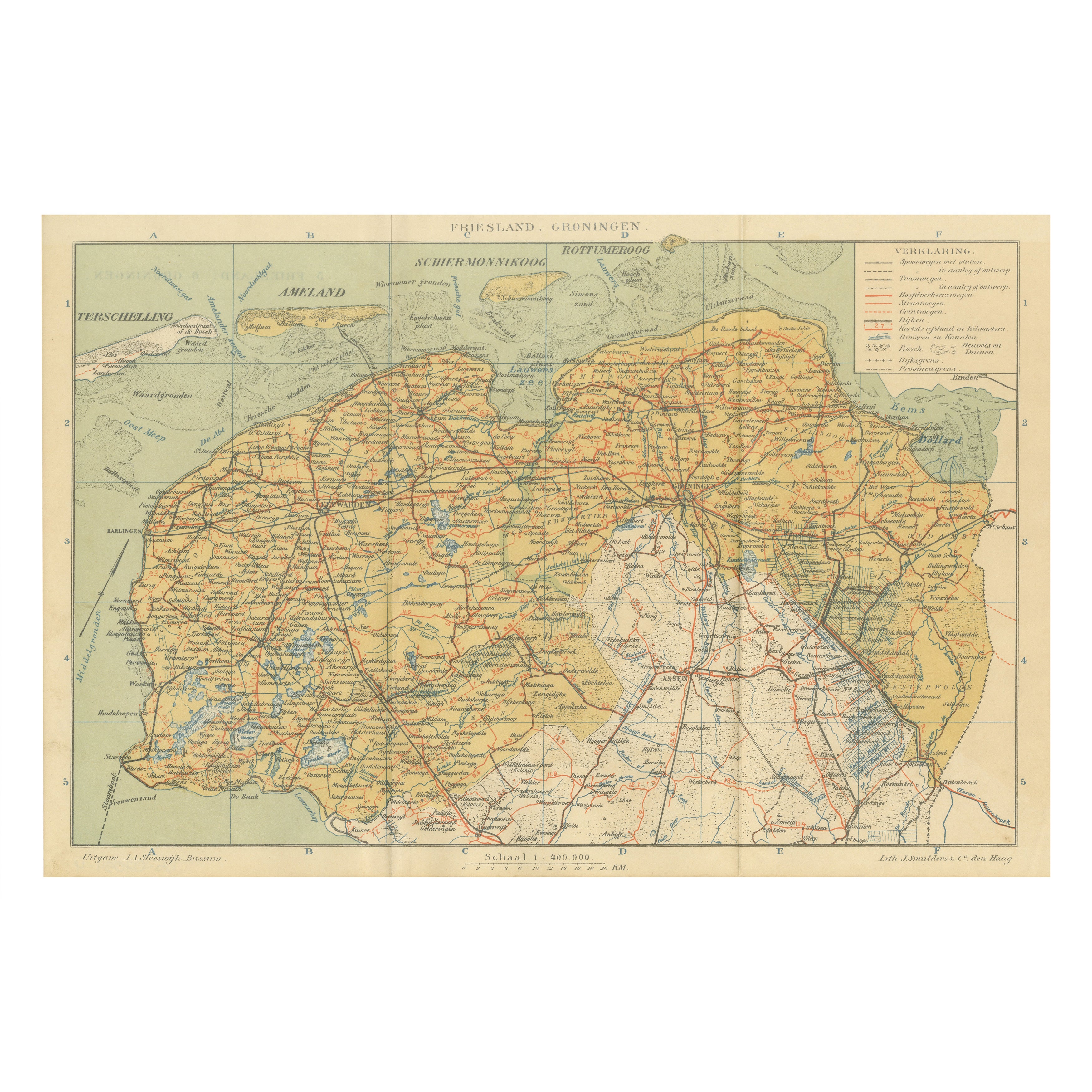
Antique Map of Friesland
Groningen – Sleeswijk Atlas Dutch Provinces, 1914
Located in Langweer, NL
Antique Map of Friesland & Groningen – Sleeswijk Atlas, 1914
Description:
This antique map of Friesland and Groningen was published in 1914 in the Sleeswijk Atlas, a Dutch school at...
Category
Early 20th Century Dutch Maps
Materials
Paper
Antique Map of the Dutch Province of Noord-Holland, 1883
Located in Langweer, NL
Antique map titled 'Noord-Holland'. Map of Noord-Holland, a province of the Netherlands. This map originates from 'Atlas van Nederland volgens de nieuwe spelregels' by J. Kuyper. Art...
Category
Antique 19th Century Maps
Materials
Paper
You May Also Like
The Netherlands (Holland), Belgium and Luxemburg. Century Atlas antique map
Located in Melbourne, Victoria
'The Century Atlas. The Netherlands (Holland), Belgium and Luxemburg.'
Original antique map, 1903.
Inset maps of 'Amsterdam' and 'Brussels'.
Central fold as issued. Map name and num...
Category
Early 20th Century Victorian More Prints
Materials
Lithograph

North Holland, Netherlands: A Large 17th C. Hand-colored Map by Sanson
Jaillot
By Nicholas Sanson d
Abbeville
Located in Alamo, CA
This large hand-colored map entitled "Le Comte De Hollande Dressee sur les Memoires les plus Nouveaux" was originally created by Nicholas Sanson d'Abbeville. This version was publish...
Category
1690s Landscape Prints
Materials
Engraving

Original Antique Map or City Plan of Amsterdam, Netherlands. Circa 1835
Located in St Annes, Lancashire
Nice map of Amsterdam
Drawn and engraved by J.Dower
Published by Orr & Smith. C.1835
Unframed.
Free shipping
Category
Antique 1830s English Maps
Materials
Paper

Belgium and the Netherlands: A Hand-colored 17th Century Map by Visscher
By Nicolaus Visscher
Located in Alamo, CA
This is an original hand-colored 17th century map of Belgium by Nicolaus (Nicolas) Visscher II entitled "Belgium Foederatum emendate auctum et novissime editum", published in Amsterdam in 1678. The map shows the seven provinces comprising the Belgium federation or the Republic of the Seven United Netherlands or the Dutch Republic as it was also known. The republic was formed when an alliance of seven Dutch provinces in the Spanish Netherlands revolted against rule by Spain in 1579 (the Union of Utrecht) and declared their independence in 1581 (the Act of Abjuration). The seven provinces were Groningen, Frisia, Overijssel, Guelders, Utrecht, Holland and Zeeland. This was a predecessor state to the Netherlands and the first fully independent Dutch nation state. Amsterdam, Delft, Rouen, Utrecht, Brugge, Ghent, and Antwerp are all included on the map. A small inset map in the lower right depicts the course of the Maas River from Maastricht to Wessem. There is a decorative cartouche in the upper left corner and a distance scale cartouche in the lower right corner.
The map is presented in an attractive antiqued medium brown-colored wood frame with gold-colored inner and outer trim and a light tan-colored fabric mat. The frame measures 26.63" high by 30" wide by 0.75" deep. There is some darkening of the red areas in the map, presumably related to oxidation of the original iron containing pigment over time. There are also a few scattered spots. The map is otherwise in very good condition.
The Visscher family were one of the great cartographic families of the 17th century. Begun by Claes Jansz Visscher...
Category
Late 17th Century Other Art Style Landscape Prints
Materials
Engraving

1752 Vaugoundy Map of Flanders : Belgium, France, and the Netherlands, Ric.a002
Located in Norton, MA
Large Vaugoundy Map of Flanders:
Belgium, France, and the Netherlands
Colored -1752
Ric.a002
Description: This is a 1752 Didier Robert de Vaugondy map of Flanders. The map de...
Category
Antique 17th Century Unknown Maps
Materials
Paper

Large Original Vintage Map of Israel, circa 1920
Located in St Annes, Lancashire
Great map of Israel
Original color.
Good condition
Published by Alexander Gross
Unframed.
Category
Vintage 1920s English Edwardian Maps
Materials
Paper
